|
September  1st 1862 The Battle of Ox Hill (or Chantilly) is also known as the only major Civil War battle to have been fought during a storm. "The crash of thunder and the vividness of the lightning, whose blinding flashes seemed to be in our very midst, caused the uneasiness and disturbance among some of the bravest men." (p.35 - 37 Washington Weather Book 2002 by Ambrose, Henry, Weiss) 1869 Professor Cleveland Abbe of the Cincinnati Astronomical Society realized the value of plotting telegraph weather reports to forewarn about killer storm on the Great Lakes. Abbe assembled a partnership with the Associated Press, Western Union and the remaining Smithsonian observers. His bulletins would be the first public weather forecasts. (Ref. Wilson Wx. History) 1894 A forest fire driven by high winds burned down the town of Hinkley, MN killing 418 persons. (David Ludlum) 1897 Hailstone drifts six feet deep were reported in Washington County, IA. (The Weather Channel) (Ref. WxDoctor) 1914 The town of Bloomington Michigan was deluged with 9.78 inches of rain in 24 hours to establish a state record. (31st - 1st) (The Weather Channel) A trace of snow fell at Long Falls Dam, ME and a half inch was reported atop Mt. Washington, NH. (Ref. AccWeather Weather History) 1935 The 1935 Labor Day Hurricane began intensifying from a tropical storm early in the day to a Category 2 by the end of this day. Over the next 24 hours the cyclone would go through "bombogenesis" intensifying to a Category 5 storm with maximum sustained winds estimated at 160 mph with gusts exceeding 200 mph. This was the first Category 5 storm to hit the U.S. The records aren't good enough to say whether any earlier storms that hit the USA would be Category 5 by today's standards. (Ref. Jack Williams, USA Today.com) 1939 Lightning hit and killed 837 sheep bedded down for the night on top of Pine Canyon in Northwestern Utah. Both the sheep and the earth were wet from the passing thunderstorm, causing the lightning's electrical discharge to move completely through the herd. The sheepherder was in a tent, was knocked temporary unconscious but escaped death. (Ref. National Weather Service in Utah Lightning Information) 1950 Palm Springs, CA set their all-time September high temperature record with 121°. Other daily record highs included: Yuma, AZ: 123°, Phoenix, AZ: 116°, Las Vegas, NV: 113°, Sacramento, CA: 108°, Tucson, AZ: 107°, Stockton, CA: 105°, Bishop, CA: 104°, Winnemucca, NV: 101°, Winslow, AZ: 99°, Reno, NV: 99°, Elko, NV: 97° and Ely, NV: 93°. (Ref. Wilson Wx. History) 1952 Hurricane Able moved on NE track to west of the DC. area at 26 mph. Total rainfall was 2.86 inches in Washington, DC. (Ref. Washington Weather Records - KDCA) 1953 A heat wave that began in late August continued into early September continued across parts of the Midwest. Platteville, WI & South Bend, IN recorded their hottest September temperatures with 100° and 99° respectively. Fort Wayne, IN & Muskegon, MI tied their all-time September high temperature record with 100° & 95°. Other daily record highs included: Goshen, IN: 101°, Grand Rapids, MI: 97°, Lansing, MI: 96°. (Ref. Wilson Wx. History) 1955 The temperature at Los Angeles, CA soared to an all-time high of 110 degrees during an eight day string of 100 degree weather. (David Ludlum) (Ref. WxDoctor) 1974 Lt. Judy Neuffer became the first female to fly a Hurricane Hunter aircraft through the eye of a hurricane. (Ref. Wilson Wx. History) 1979 A home in Centerville, TN was hit by lightning and totally destroyed. It marked the third time that the house had been hit by lightning since being built in 1970. (The Weather Channel) An explosion aboard an oil tanker in the Houston Ship Channel was caused by lightning from a thunderstorm associated with Tropical Storm Elena. 3 people were killed. People downwind from the explosion reported black, oily raindrops. (Ref. AccWeather Weather History) 1983 Record heat gripped parts of the northern Rockies. Several locations recorded record highs for September including: Miles City, MT: 106°, Billings, MT: 103° and Sheridan, WY: 103°. At Billings, it was the 8th consecutive day with high temperatures above 90°. (Ref. Wilson Wx. History) 1985 Erratic Hurricane Elena baffled forecasters and Gulf Coast residents on the Sunday before Labor Day. The Hurricane had threatened the central Gulf Coast on Friday, only to turn east and spend Saturday menacing the Tampa Bay area with high winds, tides and heavy rains. By lunchtime Sunday, Elena was on the move again, but this time back to the west. The storm reached its minimum pressure of 951 millibars or 28.08 inches of mercury while the storm was 75 miles south of Apalachicola, FL. Elena's maximum reported coastal winds were over Dauphin Island, AL, where sustained winds of 105 mph with gusts to 135 mph were reported. Other maximum gusts reported ranged from 120 mph at Gulfport, MS, to 92 mph at Pensacola, FL. Maximum tides of 10 feet above normal were recorded at Apalachicola, FL, with reports of 6 to 8 feet above normal on Dauphin Island, AL. Approximately 1 million people were evacuated from low lying coastal areas during Elena’s approach. This large evacuation contributed to the fact that there were no deaths in the area of landfall. The four deaths which occurred resulted from falling trees and automobile accidents. One resident died of a heart attack. Total damage ranged from $1 to $1.5 billion dollars. (David Ludlum) (Ref. AccWeather Weather History) 1987 Cool Canadian air invaded the Midwest. Six cities reported record low temperatures for the date, including Indianapolis, Indiana with a reading of 44 degrees. Hot weather continued in the northwestern U.S. Five cities reported record high temperatures for the date, including Hanover, WA, where the mercury soared to 106 degrees. (The National Weather Summary) Remnants of Tropical Storm Lidia brought thunderstorms to the San Diego valleys with lightning and strong damaging winds, possibly a tornado. Lightning struck a power pole in El Cajon, which ruptured gas lines. Another bolt started a house fire there. Lightning caused several small fires in the area. What was reported as a dust devil was probably a microburst or a tornado that damaged awnings and other items to mobile homes near Lake Jennings. In El Cajon a tree with an 8-inch trunk was snapped in half. 35 mph winds were reported at Pt. Loma. (Ref. Wilson Wx. History) 1988 Thunderstorms produced heavy rain in the Upper Mississippi Valley. Ely, MN was drenched with three inches of rain in two hours, and pelted with one-inch hail. The heavy rain flooded streets and basements, and the high water pressure that resulted blew the covers off manholes. (The National Weather Summary) (Storm Data) 1989 Thunderstorms developing ahead of a cold front produced severe weather in Oklahoma during the late afternoon and evening hours. Thunderstorms produced hail two inches in diameter west of Arapahoe, and wind gusts to 70 mph at Luther and south of Harrah. Early morning thunderstorms over Indiana drenched Kokomo with five to eight inches of rain, and spawned a tornado that injured three persons at Bruce Lake. (The National Weather Summary) (Storm Data) 1990 Severe thunderstorms tore across portions of northwest South Dakota. The thunderstorms produced huge hail and damaging winds. Hail as big as grapefruit fell at Sorum doing tremendous damage to houses and farm buildings. The next day, thunderstorm winds approaching 90 mph ripped the roofs of outbuildings and in some cases carried the debris for over 2 miles. (Ref. Wilson Wx. History) 1999 Erratic Dennis was downgraded to a Tropical Storm as he drifted aimlessly just off Cape Hatteras, NC. Dennis would move southward, then northwestward before making landfall on the 4th with winds of 70 mph. Dennis' heavy rains would set the stage for massive flooding when Hurricane Floyd arrived a few weeks later. (Ref. Wilson Wx. History) 2002 Across southern California, a heat wave sent temperatures soaring to 118° at Dulzura, 113° at Temecula, and 112° at Riverside and Menifee. Temperature gradients were remarkable near the coast. It was 77° at Newport Beach and 107° in Santa Ana, only ten miles difference, 72° in Oceanside Harbor and 87° in Oceanside Airport, only two miles difference, 81° in Sea World to 91° in San Diego - Lindbergh Field, only three miles difference. (Ref. Wilson Wx. History) 2003 By midnight, Indianapolis, IN recorded its wettest day on record with 7.20 inches. (Ref. Wilson Wx. History) 2006 Norfolk, Virginia: Norfolk breaks its record for wettest day with 8.93 inches of rain. (Ref. WxDoctor) 2008 Hurricane Gustav was the second most destructive hurricane of the 2008 Atlantic hurricane season. The storm was the seventh tropical cyclone, third hurricane, and second major hurricane of the season. Gustav caused serious damage and casualties in Haiti, the Dominican Republic, Jamaica, the Cayman Islands, Cuba and the United States. Gustav caused at least $6.6 billion (2008 USD) in damages. Gustav triggered the largest evacuation in United States history up to 2008. Once into the Gulf, Gustav gradually weakened because of increased wind shear and dry air. It weakened to a Category 2 hurricane late on August 31, and remained at that intensity until landfall on the morning of September 1 near Cocodrie, Louisiana. In total, an estimated 153 deaths had been attributed to Gustav in the U.S. and Caribbean. Information on Gustav from Wikipedia.org Track of Gustav - Weather Underground 2017 Harvey was a Category 4 hurricane at its peak. On Tuesday afternoon the 29th, the Mont Belvieu industrial suburb east of Houston recorded 51.12 inches of water, breaking the highest previous record of 48 inches from 1978’s Tropical Storm Amelia in Medina, Texas. Hurricane Harvey was the first major hurricane[nb 1] to make landfall in the United States since Wilma in 2005, ending a record 12-year period with no major hurricanes making landfall in the United States. In a four-day period, many areas received more than 40 inches (1,000 mm) of rain as the system meandered over eastern Texas and adjacent waters, causing catastrophic flooding. With peak accumulations of 51.88 in (1,318 mm), Harvey is the wettest tropical cyclone on record in the contiguous United States. The resulting floods inundated hundreds of thousands of homes, displaced more than 30,000 people, and prompted more than 17,000 rescues. The eighth named storm, third hurricane, and the first major hurricane of the 2017 Atlantic hurricane season. Harvey has caused at least 51 confirmed deaths; 1 in Guyana, and 50 in the United States. Catastrophic inland flooding is ongoing in the Greater Houston metropolitan area. FEMA director Brock Long called Harvey the worst disaster in Texas history, and expected the recovery to take many years. Preliminary estimates of economic losses range from $30 billion to $150 billion, with a large portion of the losses sustained by uninsured homeowners. “This is as catastrophic as you could possibly imagine from a Category 4 storm.” (SE,TX After 30 to 45 inches of rain and more to come) (Map of Rainfall totals) (Another Raibfall Total Map) (Mont Belvieu recorded 51.12 inches of Rain) (This maybe the Greatest US Storm Damage- Estamates of 50 Billion and more) (5 Day Map of the Forecasted Path) (Updated Map of the Storm's Track) Aftermath of Harvey Rescuing-People Aftermath of the Storm 2019 Meteorological history of Hurricane Dorian- History of Hurricane Dorian (Ref.Wikipedia.com) The Eye of Hurricane Dorian- The Eye of Hurricane Dorian-(Ref.Wikipedia.com) Late on September 1 and early on September 2, Dorian was moving at just a few miles per hour and blowing maximum sustained winds as high as 185 miles (295 kilometers) per hour. Dorian was “stationary,” For an extraordinary 40 consecutive hours, the storm hovered over the small island, lashing it with extreme rain, waves, and wind. (Ref. Timothy Hall, NASA Goddard Institute of Space Studies scientist.) The path of Dorian from the 24 of August to September 5- The path of Dorian (Ref. NWS Video) Picture showing how active the Atlantic and Pacific was with Tropical storms- The Atlantic and Pacific was with Tropical storms-(Ref. NASA Photo) |
|
September 2ND 1775 The Independence Hurricane This savage hurricane raged from North Carolina to Newfoundland. Heavy rains began to fall across the colony on the 29th of August and slowly increased with time. The coast was ravaged from Currituck to Chincoteague. Wharves and storehouses on the waterfront of Norfolk were devastated. Bridges were carried away by the raging waters. At Williamsburg, mill dams broke and corn stalks were blown flat. Winds blew furiously until 10:00 p.m. Many ships were damaged as they were thrown ashore at Norfolk, Hampton, and York. Around twenty-five vessels were run ashore, or "irrecoverable gone." The gun ship H.M.S. Mercury was driven hard aground on Portsmouth Point at 5:00 p.m. on the 2nd. It was stranded in two feet of water for eight days (Shomette). The Liberty became "hopelessly stranded" in Back River, near Hampton. A number of locals boarded her, captured the crew, secured her goods, and set the ship afire in the first outright act of war. A full blockade of Hampton Roads thereafter brought shipping to a halt for three months. At least twenty-five died due to shipwreck. (Ref. The Independence Hurricane) (Ref. More Information on This Storm) 1935 Labor Day Hurricane of 1935 Florida Keys hurricane---The storm killed 408 people. Perhaps the most intense hurricane ever to hit the U.S. struck the Florida Keys with 200 mph winds. The hurricane produced a fifteen-foot tide and waves thirty feet high. The barometric pressure at Matecumbe Bay, FL hits a record low for the U.S. of 26.35 inches. (David Ludlum) (Ref. WxDoctor) Information on the 1935 Hurricane from Wikipedia.org Ref. Rick Schwartz book, Hurricanes and the Middle Atlantic States. Track of the 1935 Hurricane Weather Underground 1950 The temperature at Mecca, CA soared to 126 degrees to establish a U.S. record for the month of September. The low that morning was 89 degrees. (The Weather Channel) (Ref. WxDoctor) (Ref. AccWeather Weather History) 1953 Boston, Massachusetts had 100 °F for the second time ever in September. Chicago, IL hit 101° for the second day in a row and the tenth of 11 consecutive days with a high temperature at 90° or higher. (Ref. NOAA Boston Weather Events) 1961 Denver, CO picked up 4.2 inches of snow, the earliest measurable snow for the Mile High City. (Ref. AccWeather Weather History) 1982 A wind gust of 121 mph was reported at the Chautauqua County Airport near Jamestown, NY causing an estimated half million dollars in damages to the terminal building, planes, cars and landing instruments. Rainfall totals exceeded two inches in places. (Ref. Wilson Wx. History) 1985 After teasing residents along the Gulf of Mexico for two days, Hurricane Elena finally came ashore at Biloxi, MS. The hurricane, packing winds of 127 mph, caused more than a billion dollars damage. (The Weather Channel) (Ref. AccWeather Weather History) Track of Elena - Weather Underground 1987 Late evening thunderstorms in the Northern Plains Region produced wind gusts to 75 mph at Jordan, MT, and a "hot flash" at Redig, SD. The temperature at Redig rose from 66 degrees at 10 PM to 86 degrees at 11 PM as thunderstorm winds gusted to 36 mph. Nine cities in the Upper Ohio Valley, the Tennessee Valley and the Central Gulf Coast States reported record low temperatures for the date, including Elkins, WV with a reading of 38 °F. (The National Weather Summary) (Storm Data) 1988 Unseasonably hot weather prevailed in the northwestern U.S. Afternoon highs of 98 degrees at Olympia, WA, 98 degrees at Seattle, WA, 105 degrees at Portland, OR, and 110 degrees at Medford, OR, established records for the month of September. Quillayute, WA equaled their September record with an afternoon high of 97 degrees. (The National Weather Summary) With the Summer of '88 unofficially drawing to a close, many cities across the nation's heartland and throughout the east will remember the past season as one of the hottest ever. Philadelphia, PA recorded 49 days of 90 degree-plus heat and five days over the century mark. Salt Lake City, UT averaged 77.7° throughout June, July, and August, establishing this summer as the hottest on record in 115 years. Milwaukee, WI recorded an average 3 month temperature of 73.8°, shattering previous record of 72.8° set in 1955. (Ref. Wilson Wx. History) 1989 Eight cities in the Gulf Coast Region reported record high temperatures for the date as readings soared into the upper 90s. Houston, TX and Port Arthur, TX hit 99 degrees. Late evening thunderstorms, developing ahead of a cold front, produced wind gusts to 63 mph at Dickinson, ND, and golf ball size hail in North Dakota and Nebraska. Winds along the cold front itself gusted to 62 mph at Buffalo, SD. (The National Weather Summary) (Storm Data) 1996 After teasing the entire Atlantic coast with winds as high as 140 mph, Hurricane Edouard skirted New England without making landfall. Hurricane force winds were recorded on Nantucket and Cape Cod, but wind damage was relatively minor. Large swells from Hurricane Fran knocked five people out of an 18-foot fishing boat in Jupiter Inlet, FL. The Coast Guard rescued all five people. (Ref. Wilson Wx. History) 2002 An F3 tornado roared into downtown Ladysmith, WI at mid-afternoon, heavily damaging 64 blocks of the business district. Fortunately, it was Labor Day, and most of the stores were closed for the holiday or the toll would have been much worse. The National Weather Service came under fire for not issuing a tornado warning before the storm struck. (Ref. Wilson Wx. History) 2003 Indianapolis, IN was drenched with 7.20 inches of rain on this date for its greatest single day rainfall on record. (Ref. WxDoctor) 2006 Tropical Storm Ernesto dumped 8.93 inches of rain on Norfolk, VA for the city's greatest single day rainfall on record. (Ref. Wilson Wx. History) (Sep. 1st-2nd) Heavy rains from the remnants of Tropical Storm Ernesto fell on SE PA. In Schwenksville, a man jumped into an overflowing retention basin to try to rescue his dog. The dog was sucked into and through the outflow pipe and survived; his master drowned. (Ref. Weather Guide Calendar with Phenomenal Weather Events 2011 Accord Pub. 2010, USA) 2008 Northeastern Illinois: In Chicago the thermometer at O'Hare IAP hits 94°F (34.4°C), and Midway tops out at 95°F (35°C), the first such high there in 761 days, and the warmest day of the year Kankakee, New Lennox, Plainfield and Palatine (my home town hit 97°F. (Ref. WxDoctor) 2017 Dr. Joel N. Myers, sometimes called the “father of commercial meteorology,” predicted on Wednesday, Aug. 30 that "the total losses from this storm would reach $190 billion or one percent of the nation's gross domestic product (GDP), countering the expected growth in the economy for the rest of this year." "This is the costliest and worst natural disaster in American history," Myers said. (Ref. Accu-Weather Cost Est. for Harvey 190 Billion) 2019 Meteorological history of Hurricane Dorian- History of Hurricane Dorian (Ref.Wikipedia.com) The Eye of Hurricane Dorian- The Eye of Hurricane Dorian-(Ref.Wikipedia.com) Late on September 1 and early on September 2, Dorian was moving at just a few miles per hour and blowing maximum sustained winds as high as 185 miles (295 kilometers) per hour. Dorian was “stationary,” For an extraordinary 40 consecutive hours, the storm hovered over the small island, lashing it with extreme rain, waves, and wind. (Ref. Timothy Hall, NASA Goddard Institute of Space Studies scientist.) The path of Dorian from the 24 of August to September 5- The path of Dorian (Ref. NWS Video) Picture showing how active the Atlantic and Pacific was with Tropical storms- The Atlantic and Pacific was with Tropical storms-(Ref. NASA Photo) Hurricane Dorian Damage to Abaco Islands, Bahamas |
|
September 3RD 1815 A powerful hurricane made landfall near Swansboro, NC. Damage was extensive at Onslow with great loss of life. (Ref. Wilson Wx. History) 1821 A hurricane made landfall at Long Island, near Kennedy Airport, then moved through western Connecticut. The hurricane produced a record tide at New York City. An account from the Norfolk Herald described the storm as such..... From half past 11:00 until half past 12:00, so great the fury of the elements, that they seemed to threaten a general demolition of everything within their reach. During that period the scene was awful. There was the deafening roar of the storm, with the mingled crashing of windows and falling of chimneys, while the rapid rise of the tide threatened to inundate the town. The continuous cataracts of rain swept impetuously along darkening the expanse of vision and apparently confounding the heaven, earth and seas in a general chaos; together with now and then a glimpse caught through the gloom, of shipping forced from their moorings and driven with rapidity, as the mind might well conjecture in such a circumstance to inevitable destruction. (David Ludlum) The following is an account of what happened next from Howard Pyles, writtings: "...then a dull roar came nearer and nearer, and suddenly a solid mass of wind and rain and salt spray leaped upon the devoted island with a scream. Great pines bent for a moment, then, groaning and shrieking, were torn from their centuried growth like wisps of straw and hurled one against another; houses were cut from their foundations and thrown headlong; and then a deeper roar swelled the noise of the tempest, and a monstrous wall of inky waters rushed with the speed of lightning toward the island. It struck Assateague, and in a moment half the land was a waste of seething foam and tossing pine trunks; and the next instant it struck Chincoteague, and in an unbroken mass swept away men and ponies like insects; rushing up the island, tearing its way through the stricken pine woods." (Barnes & Truitt) At Pungoteage, a ten foot storm surge led to "unexampled destruction". Damage spread north with the storm into New York and New England over succeeding days. It was considered one of the most violent hurricanes on record... with damage totaling $200,000 in Virginia. Five drowned at Chincoteague. (Ref. for Long Island Hurricane of 1821) 1909 48 °F in Washington, DC the first temperature of the season that was below 50 °F. (Ref. Washington Weather Records - KDCA) 1933 On this date through the 4th, there was extensive property damage on Florida's east coast from Vero Beach to West Palm Beach due to a landfalling hurricane. A few houses were destroyed and a number blown off their blocks. More than four million boxes of citrus were blown from the trees statewide. The property loss ran into the millions. Two deaths were attributed to storm. (Ref. Wilson Wx. History) 1953 The temperature at Erie, PA reached 99 degrees, and Stroudsburg, PA established a state record for September with a reading of 106 degrees. Washington, DC had a maximum temperature of 98 °F and Richmond had 97 °F on the 3rd which was preceded by 102 °F on the 1st and 100 °F on the 2nd. (Ref. Richmond Weather Records - KRIC) (The Weather Channel) (Ref. WxDoctor) (Ref. Many Additional Temperatures Listed On This Link) 1961 Denver, CO received 4.2 inches of snow, their earliest snow of record. (Sandra and TI Richard Sanders -1987) (Ref. AccWeather Weather History) 1967 A huge hail and windstorm affected the Texas Panhandle. Winds gusted over 100 mph and golf ball size hail fell over a large area. One hailstone measured 11 inches in diameter. Crop damage was extensive. (Ref. AccWeather Weather History) 1970 During the early evening hours, in the midst of a severe hailstorm at Coffeyville, KS, a stone 17.5 inches in circumference and nearly two pounds in weight was recovered. Average stone size from the storm was five inches in diameter, with another stone reportedly eight inches in diameter. This record has now dropped to third place. On 6/22/2003, the second largest stone was reported at Aurora, NE but for the current record see July 23, 2010 in this weather history. (David Ludlum) This is no longer the largest measured hailstone in U.S. by weight or by diameter. On July 23, 2010, after a severe thunderstorm a Vivian South Dakota resident, Les Scott, found a hailstone with a diameter of 8.0 inches and its weight was 1.9375 pounds (1 pound, 15 ounces) with a circumference of 18.62 inches. These measurements displace the previous hailstone record for weight, previously 1.67 pounds for a stone in Coffeyville, Kan., in 1970. They also surpass the record for the greatest diameter, which was 7 inches for a hailstone found in Aurora, Neb., in 2003. But the Aurora hailstone still holds the record for the greatest circumference of 18.75 inches. (Thus the Aurora hailstone was more spherical than the Vivian hailstone.) (Ref. NOAA News Release July 30, 2010 - Record Hailstone ) (Ref. See a Picture of the World's Largest Hailstone) 1972 Hurricane Hyacinth moved as far west as 125 West before recurving to the northeast. The remnants made landfall between Los Angeles and San Diego, CA with winds of 25 mph and rainfall of up to one inch in the mountains from this day through 9/6. This tropical cyclone holds the distinction of traveling the farthest west before recurving and making landfall in Southern California. This occurred during the El Nińo of 1972-73. (Ref. Wilson Wx. History) 1974 A strong Canadian air mass brought an early taste of Autumn extending the Plains to the Great Lakes & Ohio Valley. The earliest freeze on record in Sioux Falls, SD recorded their earliest freeze on record when they dropped to 31°. Other record lows included: North Platte, NE: 26°, St. Cloud, MN: 27°, Bismarck, ND: 28°, Valentine, NE: 30°, Aberdeen, SD: 31°, Huron, SD: 31°, Duluth, MN: 32 °F. (Ref. Many Additional Temperatures Listed On This Link) 1977 A 19-year-old hitch-hiker was struck and killed by lightning while leaning against a metal road sign on the southbound ramp of I-81 in Staunton, VA . Another person was injured. Witnesses said that there was no rain falling at the time and described the lightning bolt as having come "out of clear skies". In actuality, it came from a nearby thunderstorm. Also on this day in Poquoson, near hampton, Virginia around 6:20 PM, a man was struck and injured outside his home. During the period 1995 through 2000, there were seven lightning fatalities, 54 injuries and $6.5 million in damage, according to Storm Data. (Ref. Lightning - Virginia Weather History) 1979 Hurricane David made landfall about 20 miles south of Melbourne, FL with 90 mph winds. It was the first hurricane to strike the Cape Canaveral area since the hurricane of 1926. Severe erosion was reported in Brevard County and south Volusia County. Agricultural losses were substantial, exceeding $25 million dollars. Storm rainfall was quite variable with totals mostly 6 to 9 inches near the track of the eye, with a few reports to 11 inches. No deaths reported in Florida. Nine tornados were reported along the coast but caused no serious injuries. (Ref. AccWeather Weather History) 1987 Temperatures dipped into the 40s and 50s for morning lows across much of the eastern half of the country, with eleven cities reporting record lows for the date. Pellston, MI tied Gunnison, CO for honors as the cold spot in the nation with a low of 30 degrees. Smoke from forest fires darkened skies in southern Oregon and northern California. (The National Weather Summary) (Ref. Many Additional Temperatures Listed On This Link) 1988 Sixteen cities in the northwestern U.S. reported record high temperatures for the date. Highs of 89 degrees at Stampede Pass, WA and 116 degrees at Redding, CA established records for the month of September. Readings of 98 degrees at Spokane, WA and 100 degrees at Yakima, WA equaled records for September. (The National Weather Summary) 1989 Thunderstorms developing ahead of a cold front produced severe weather from Minnesota to Nebraska during the day and evening. Evening thunderstorms in Nebraska produced wind gusts to 100 mph at Valentine and Gretna, and produced baseball size hail at Lewellen. Thunderstorms in Arizona produced 2.20 inches of rain in forty minutes at Green Valley, and wind gusts to 60 mph. Eight cities in Texas and Florida reported record high temperatures for the date, including Victoria, TX and San Antonio, TX, each with a reading of 102 degrees. (The National Weather Summary) (Storm Data) 1990 Lightning tends to get a higher object of an area. The pier at a beach is often the highest structure in the vicinity. At Swan Quarter, North Carolina, five people took shelter from a thunderstorm under a wooden pier. One was killed, four were hurt when the lightning hit the pier. (Weather Guide Calendar with Phenomenal Weather Events 2007 Accord Publishing, USA) 1998 Hurricane Earl made landfall during the early morning hours near Panama City, FL as a category 1 storm with maximum sustained winds near 80 mph. The cyclone brought drought breaking rains to Georgia and the Carolinas. (Ref. AccWeather Weather History) 2002 A prolonged summer drought in southern Illinois gradually worsened, becoming severe by early September. Crop loss estimates totaled around $53 million dollars. The corn crop, which was especially susceptible to the combined effects of heat and drought, took the biggest hit. The remnants of Tropical Storm Isidore provided much-needed heavy rainfall late in September. (Ref. Wilson Wx. History) 2007 Key West, Florida: Key West records a record high reading of 95°F. This event is the first occurrence of a 95 °F or higher reading since August 1957. (Ref. WxDoctor) 2016 Tropical Storm Hermine made landfall in Florida on Friday, September 2, 2016 at 7:26 PM - as a Category 1 hurricane early Friday, leaving one dead and causing severe coastal damage in its wake. Hermine was the first hurricane to make landfall in the state since Wilma struck 11 years ago. It was only a Cat-1 hurricane but the rain in NC set the stage for a Major Flood with Matthew in October. 58,000 without power in Hampton Roads, Virginia The main problems in the Virginia Beach area was flooding The event covered by Weatherwise Magazine 2019 Meteorological history of Hurricane Dorian- History of Hurricane Dorian (Ref.Wikipedia.com) The Eye of Hurricane Dorian- The Eye of Hurricane Dorian-(Ref.Wikipedia.com) Late on September 1 and early on September 2, Dorian was moving at just a few miles per hour and blowing maximum sustained winds as high as 185 miles (295 kilometers) per hour. Dorian was “stationary,” For an extraordinary 40 consecutive hours, the storm hovered over the small island, lashing it with extreme rain, waves, and wind. (Ref. Timothy Hall, NASA Goddard Institute of Space Studies scientist.) The path of Dorian from the 24 of August to September 5- The path of Dorian (Ref. NWS Video) Picture showing how active the Atlantic and Pacific was with Tropical storms- The Atlantic and Pacific was with Tropical storms-(Ref. NASA Photo) Hurricane Dorian Damage to Abaco Islands, Bahamas |
|
September 4TH 1766 An intense hurricane struck Galveston Bay, TX, driving five Spanish treasure ships aground. Most of the treasure was salvaged, but the ships were totaled. (Ref. Wilson Wx. History) 1939 Once-in-a-hundred-years rainstorm in Washington, DC -- A thunderstorm deluged Washington, DC with 4.4 inches of rain in two hours. September of that year was very dry across much of the nation, and Washington Washington, DC. received more rain in that two-hour period than most other places in the country that entire month. (David Ludlum) (Ref. WxDoctor) The remnants of a hurricane tracked northeastward across northern Baja California into southwest Arizona starting on this day and ending on 9/6. Up to 7 inches of rain fell on the mountains and deserts. Blythe, CA received more rain than would normally fall in a year and Imperial, CA received more rain than would normally fall in two years. Four tropical cyclones would impact Southern California during the month of September 1939, an unprecedented occurrence. (Ref. Wilson Wx. History) 1941 Six people were killed when a tornado struck Minneapolis, MN. (Ref. AccWeather Weather History) 1945 Record heat blasted parts of the Southwest into the Plains. The high of 108° established the record high for the month of September at Liberal, KS. Other daily records included: Yuma, AZ: 116°, Phoenix, AZ: 112°, Las Vegas, NV: 109°, Tucson, AZ: 106 °F. (Ref. Wilson Wx. History) 1965 Hurricane Betsy stalled 350 miles east of Jacksonville, FL just before the busy Labor Day holiday weekend, causing major headaches for weather forecasters. (Ref. AccWeather Weather History) 1970 The greatest natural disaster of record for Arizona occurred. Unprecedented rains caused rivers in central Arizona to rise five to ten feet per hour, sweeping cars and buildings as far as 30 to 40 miles downstream. Flooding claimed the lives of 23 persons, mainly campers, and caused millions of dollars damage. Water crested 36 feet above normal near Sunflower, AZ. Workman's Creek was deluged with 11.40 inches of rain in 24 hours to establish a state record. Moisture from Pacific Tropical Storm Norma led to the severe flooding. (4th-6th) (The Weather Channel) 1983 Record heat occurred across parts of the Midwest and Plains ahead of a strong cold front. Record highs included: El Paso, TX: 101°, Roswell, NM: 100°-Tied, Chicago, IL: 95 °F -Tied. (Ref. Wilson Wx. History) 1986 An unusually strong dust devil moved across the Flagstaff Pulliam Airport. The dust devil blew open the doors of the National Weather Service office scattering papers and bringing down a ceiling-mounted light fixture. (Storm Data) 1987 Thunderstorms developing along a stationary front produced heavy rain across the Southern Atlantic Coast States. Up to eight inches was reported north of Charleston, SC. Serious flooding was reported in Monks Corner, SC. Seven cities in the northeastern U.S. reported record low temperatures for the date. Houlton, ME dipped to 32 degrees. (The National Weather Summary) (Storm Data) 1988 The western U.S. experienced another day of record heat. The afternoon high of 91 degrees at Stampede Pass, WA established an all-time record for that location, and Los Angeles, CA equaled their all-time record high with a reading of 110 degrees. A record high of 107 degrees at San Diego, CA was their hottest reading in 25 years. Red Bluff, CA was the hot spot in the nation with an afternoon reading of 118 degrees. (National Weather Summary) 1989 Overnight thunderstorm rains of four and a half to seven inches drenched eastern Nebraska during the morning hours, pushing creeks out of their banks, and flooding fields, country roads and city streets. Totals ranged up to 6.97 inches south of Creston. It was also a soggy Labor Day for northern Florida. Jacksonville reported 6.82 inches of rain, and evening thunderstorms produced 2.75 inches of rain in one hour at Sandlewood. (Storm Data) (The National Weather Summary) 1996 Hurricane Fran reached peak strength of 120 mph 275 miles off the east coast of Florida. The Space Shuttle Atlantis had to be rolled back from its launch pad at Cape Canaveral as the storm threatened the east coast of Florida. The storm would make landfall the following evening on the North Carolina coast to become the most damaging hurricane of the 1996 Atlantic season. (Ref. AccWeather Weather History) 1998 Scottsbluff, NE equaled their warmest September temperature with a high of 102°. Other record highs included: Fort Smith, AR: 109°, Dallas, TX: 108°, Dallas (DFW), TX: 108°, Wichita Falls, TX: 108°, Oklahoma City, OK: 107°, Tulsa, OK: 107°, Waco, TX: 106° and Austin (Camp Mabry), TX: 101°. (Ref. Wilson Wx. History) 2000 Houston and College Station, TX recorded their hottest day on record when highs reached 109° and 112° respectively. Other daily record highs included: Wichita Falls, TX: 111°, Waco, TX: 111°, Dallas, (DFW), TX: 111°, Austin, (Bergstrom), TX: 110°, Austin (Camp Mabry), TX: 110°, Dallas, TX: 110°, Victoria, TX: 110°, San Antonio, TX: 109°, Shreveport, LA: 108°, Corpus Christi, TX: 107 °F (Ref. Many Additional Temperatures Listed On This Link) 2006 A slow moving low pressure system triggered scattered thunderstorms across northern Illinois during the afternoon. A series of slow moving storms moved into and sat over the east side of Rockford. As much as 5 to 10 inches of rain fell in a localized area, while less than 3/4 inch fell nearby at the airport. Damage was estimated around $20 million dollars. (Ref. Wilson Wx. History) 2007 Hurricane Felix came ashore in the pre-dawn hours as a Category 5 storm on the Miskito Coast in Nicaragua. At the time of its landfall, the maximum sustained surface winds were approximately 160 mph. Felix killed at least 130 people along the Miskito Coast, with damage in Nicaragua totaling $46.7 million dollars. With Felix following the footsteps of Hurricane Dean, also a Category 5 hurricane, it marks the first time since record-keeping began that the first two hurricanes of the Atlantic hurricane season reached Category 5 intensity and also the first season where two hurricanes made landfall at Category 5. (Ref. Wilson Wx. History) Marquette, Michigan: A deluge of 4.29 inches (109 mm) of rain swamps Marquette. The downpour not only smashes the previous maximum precipitation record for the date, but also sets the all-time daily maximum precipitation record since the station was moved to that location in 1961. (Ref. WxDoctor) 2008 The remnants of Hurricane Gustav brought heavy rains to southern Lower Michigan. Muskegon set a daily rainfall record of 3.25 inches and Grand Rapids sets a record with 2.82 inches. (Ref. Wilson Wx. History) 2019 Meteorological history of Hurricane Dorian- History of Hurricane Dorian (Ref.Wikipedia.com) The Eye of Hurricane Dorian- The Eye of Hurricane Dorian-(Ref.Wikipedia.com) Late on September 1 and early on September 2, Dorian was moving at just a few miles per hour and blowing maximum sustained winds as high as 185 miles (295 kilometers) per hour. Dorian was “stationary,” For an extraordinary 40 consecutive hours, the storm hovered over the small island, lashing it with extreme rain, waves, and wind. (Ref. Timothy Hall, NASA Goddard Institute of Space Studies scientist.) The path of Dorian from the 24 of August to September 5- The path of Dorian (Ref. NWS Video) Picture showing how active the Atlantic and Pacific was with Tropical storms- The Atlantic and Pacific was with Tropical storms-(Ref. NASA Photo) Hurricane Dorian Damage to Abaco Islands, Bahamas |
|
September 5TH 1913 Record late summer heat blasted parts of the Midwest & Missouri Valley. Quincy, IL & Osage, IA set their highest September temperatures on record with 105° & 101° respectively. Other daily records included: Tulsa, OK: 107°, Sioux Falls, SD: 104°, Dallas-Fort Worth, TX: 104°, Lincoln, NE: 103°, Topeka, KS: 102°, Huron, SD: 102°, Norfolk, NE: 101°, Omaha, NE: 100 °F. (Ref. Wilson Wx. History) 1922 An intense lightning storm killed two boys taking refuge under a stock of grain in the Seamans District, Saskatchewan Canada. (Ref. Wilson Wx. History) 1925 The temperature in Centerville, AL was 112 degrees to establish a state record and is also the latest date in the summer to set a record high maximum for any state. Every reporting station in Alabama was 100 degrees or above that afternoon. (The Weather Channel) (Ref. Many Additional Temperatures Listed On This Link) (Ref. Lowest and Highest Temperatures for the 50 States) 1929 3 inches of early season snow was recorded near Lusk, WY. (Ref. Wilson Wx. History) 1933 A hurricane hit Brownsville, TX killing forty persons and causing 12 million dollars damage. (David Ludlum) 1935 The greatest daily precipitation to occur in the month of September in Richmond, Virginia was 4.91 inches and 1.97 inches on the 6th as the 1935 Labor Day hurricane passed to the SE of Richmond. Great Labor Day Hurricane (Ref. Richmond weather records starting in 1897) 1938 A streak of 10 consecutive days with measurable rainfall for La Crosse, WI began on this date. The streak ran through the 14th, with a total of 6.89 inches falling during the period. (Ref. Wilson Wx. History) 1944 The temperature at Portland, OR soared to 102°, the only time in the city's history the temperature reached the century mark in September. Other daily records across the country included: Medford, OR: 103°, Salem, OR: 103°, Lewiston, ID: 103°, Augusta, GA: 102°-Tied, Eugene, OR: 101 °F. (Ref. Wilson Wx. History) 1950 Hurricane Easy produced the greatest 24-hour rainfall in U.S. weather records. The hurricane deluged Yankeetown, on the upper west coast of Florida, with 38.7 inches of rain. (David Ludlum) (Ref. AccWeather Weather History) On this date through the 6th, Hurricane Easy looped twice off the west coast of Florida, moving little from the 4th through the 6th. This slow movement allowed tremendous rainfall amounts to accumulate in some areas. The 24-hour rainfall of 38.7 inches that fell at Yankeetown from this date through the 6th is the highest ever in Florida, and the second highest all-time 24 hour amount in North America. Easy had top winds of 125 mph and a barometric pressure of 958 millibars or 28.30 inches of mercury. Cedar Key reported hurricane force winds from 6 AM to 6 PM on this date. (Ref. Wilson Wx. History) 1954 A dominate heat ridge across the Ohio Valley was responsible for a three day heat wave that started on this date. Daily records included: Paris, IL: 105°, Nashville, TN: 105°, Decatur, IL: 104°, Louisville, KY: 104°, Paducah, KY: 104°, Lexington, KY: 103°, Tupelo, MS: 103°, Knoxville, TN: 103°, Memphis, TN: 103°, St. Louis, MO: 103°-Tied, Evansville, IN: 103°-Tied, Chattanooga, TN: 102°, Oak Ridge, TN: 102°, Charlotte, NC: 101°, Roanoke, VA: 101°, Indianapolis, IN: 100°, Cincinnati, OH: 100°, Richmond, VA: 100 °F. (Ref. Many Additional Temperatures Listed On This Link) 1965 One of the most unpredictable hurricanes ever in the North Atlantic, Hurricane Betsy, was making a series of loops off the Southeastern U.S. coast. Hurricane Betsy baffled forecasters and upsetting the Labor Day Holiday plans for millions of vacationers. (Ref. AccWeather Weather History) Severe thunderstorms crossed southwest Oklahoma. The storms brought torrential rain, up to five inches in one hour at some locations, which caused street flooding in Martha, Blair, and Hester. Some residents had water up to their porches. The storms also produced strong winds that caused major damage in Blair. (Ref. Wilson Wx. History) 1969 Heavy thunderstorms produced flooding across low lying areas of the northwest suburbs and the northwest side of Chicago, IL. 1.28 inches of rain was recorded in about 30 minutes at O’Hare Airport. (Ref. Wilson Wx. History) 1970 Arizona on the 4th and 5th: Moisture from Pacific Tropical Storm Norma causes severe flooding that claims the lives of 23 persons, mainly campers, and caused millions of dollars damage, the greatest natural disaster in Arizona. Flash flooding from the rains forces rivers in central Arizona to rise five to ten feet per hour, sweeping cars and buildings downstream. Flood waters crest 36 feet above normal near Sunflower, AZ. Workman's Creek is swamped with 11.40 inches of rain in 24 hours to establish a state record. (Ref. WxDoctor) 1971 Hurricane Ginger was born in the Atlantic and would be active for 31 days, setting the record as longest lived tropical cyclone on record. (Ref. Wilson Wx. History) 1975 Strong winds reduced visibilities to near zero in blowing dust resulting in a 22-car chain reaction accident on Interstate 10 near Toltec, AZ. Two persons were killed, and 14 others were injured. (The Weather Channel) 1979 Tropical storm David 7 inches rain, National Airport 3.68 and spawns at least two tornadoes rarely do dying tropical cyclones produce as many tornadoes as Hurricane David. The storm made landfall near Savannah, Ga., then tracked through interior sections of the Eastern Seaboard. The storm produced dozens of tornadoes and flash flooding in the Mid-Atlantic region on September 5th-6th. Baltimore, Md., experienced one of its most destructive flash floods as more than six inches of rain fell, most within a few hours, in a swath between Washington, DC, and Baltimore. Hurricane David spawned eight tornadoes across the greater Washington metro area. The strongest tornado was an F3 in Fairfax County that tracked 18 miles, killing one and injuring six. Fairfax County had $2.5 million in damages. Track of David - Weather Underground 1987 Thunderstorms over the Southern and Middle Atlantic Coast States drenched Charleston, SC with 5.50 inches of rain, and a total of 13.50 inches in two days, flooding homes, and leaving roads and bridges under water. (The National Weather Summary) A tropical storm that formed off the South Atlantic coast was responsible for torrential rains over coastal regions of South Carolina. Between the 30th of August and the 8th of September, Charleston, SC received 18.44 inches of rain. The heavy rains caused extensive flooding around the city of Charleston, seriously damaged cotton crops in the eastern part of the state, and resulted in a very large number of mosquitoes. (Storm Data) 1988 Five days of heavy rain commenced in west central Florida. Up to 20 inches of rain in four days resulted in extensive urban flooding, and evacuation of 1000 homes. Flooding claimed four lives, and caused more than five million dollars property damage. (The National Weather Summary) (Storm Data) 1989 Thunderstorms produced six to ten inches of rain in south central Kansas between 6 AM and noon. Serious flooding was reported around Wichita, with water four feet deep along some roads. A cold front crossing the Northern High Plains Region produced wind gusts to 63 mph at Sheridan, WY. (Storm Data) (The National Weather Summary) 1990 Nine inches of rain fell over the next two days in Duluth, washing out a million dollars worth in roads. (Ref. AccWeather Weather History) 1991 Flooding surged down the Newsome Creek Canyon in Oregon. A wall of water five feet deep and 200 feet wide roared down the canyon sweeping farm equipment, animals and vehicles downstream as far as six miles. One man drowned. (Ref. AccWeather Weather History) 1996 Hurricane Fran made landfall near Cape Fear, NC with 115 mph sustained winds. The area had just finished cleaning up from Hurricane Bertha less than two months earlier. A storm surge of up to 12 feet occurred in Onslow County. 90% of the homes were damaged or destroyed at North Topsail Beach. 6 to 14 inches of rain fell in sections of North Carolina, Virginia, and West Virginia with widespread flash flooding. As many as 34 people were killed by Fran and total damage was $3.2 billion dollars. Hurricane Fran was the most costly natural disaster in North Carolina's history. (Ref. AccWeather Weather History) 1997 Erika reached hurricane strength in the Atlantic. The hurricane was notable because it was the only named storm in the Atlantic during the months of August and September. That was the first time since 1929 that only one tropical storm strength system formed in the Atlantic during these two months. (Ref. Wilson Wx. History) 2000 Another day of record heat gripped Texas. All-time record high temperatures were set at Austin, TX: 112°, San Antonio, TX: 111°, Victoria, TX: 111°, Corpus Christi, TX: 109° and Galveston, TX: 104°. Other record highs included: Del Rio, TX: 109°, Houston, TX: 108°, Waco, TX: 108°, Abilene, TX: 107°, San Angelo, TX: 106°, Brownsville, TX: 105°, Beaumont-Port Arthur, TX: 104°, Lake Charles, LA: 104°, Lubbock, TX: 102°, Baton Rouge, LA: 101° and Alamosa, CO: 86°-Tied. (Ref. Wilson Wx. History) 2003 Category 3 Hurricane Fabian pounded Bermuda with sustained winds of 120 mph and driving rain. The storm knocked out power in 26,000 homes and ripped wind-measuring instruments from their moorings at Bermuda's Weather Service Office. Fabian was the strongest hurricane to hit Bermuda since Hurricane Arlene in 1963. Damage was estimated at $300 million dollars. (Ref. Wilson Wx. History) 2004 Hurricane Frances moved onto the coast of Florida in the early hours of September 5. It traveled northwest over land, briefly emerging over the Gulf of Mexico and striking the Florida panhandle. Track of Frances - Weather Underground Hurricane Frances made landfall at Hutchinson Island on the east central coast of Florida with winds of 105 mph and a central pressure of 960 millibars or 28.35 inches of mercury. An 8 foot storm surge occurred at Vero Beach and High Springs was drenched with 15.84 inches of rain. Frances moved northwestward crossing Florida, into Georgia, and then recurved northeastward up the Appalachians over the next several days, dumping excessive rains: 23.57 inches at Mt. Mitchell, NC, 18.07 inches at Linville Falls, SC and 11.50 inches at Big Meadows, VA. Frances spawned a near record 106 tornadoes. There were 7 fatalities and total damage was $9 billion dollars. (Ref. Wilson Wx. History) 2007 As many as three tornadoes are reported during the afternoon near Soda Springs in southeast Idaho, one tornado downed 46,000-volt power lines. (Ref. Wilson Wx. History) 2017 Above: Infrared-wavelength [or visible-wavelength] GOES-16 satellite image of Category 5 Hurricane Irma as of 9 am EDT Tuesday, September 5, 2017. Hurricane Irma intensified into an extremely dangerous high-end Category 5 storm with top sustained winds of 180 mph on Tuesday morning, putting it among the strongest Atlantic hurricanes ever observed. Irma's winds are the most powerful ever measured in an Atlantic hurricane north of the Caribbean and east of the Gulf of Mexico. Measurements from Hurricane Hunter aircraft found peak winds of close to 180 mph, well above the 157-mph threshold for Category 5 strength. The most powerful ever measured in an Atlantic hurricane 2019 Meteorological history of Hurricane Dorian- History of Hurricane Dorian (Ref.Wikipedia.com) The Eye of Hurricane Dorian- The Eye of Hurricane Dorian-(Ref.Wikipedia.com) Late on September 1 and early on September 2, Dorian was moving at just a few miles per hour and blowing maximum sustained winds as high as 185 miles (295 kilometers) per hour. Dorian was “stationary,” For an extraordinary 40 consecutive hours, the storm hovered over the small island, lashing it with extreme rain, waves, and wind. (Ref. Timothy Hall, NASA Goddard Institute of Space Studies scientist.) The path of Dorian from the 24 of August to September 5- The path of Dorian (Ref. NWS Video) Picture showing how active the Atlantic and Pacific was with Tropical storms- The Atlantic and Pacific was with Tropical storms-(Ref. NASA Photo) Satellite Image on Sep. 5th at Noon-(Ref. NASA Photo) Radar Image on Sep. 5th at 1141AM-(Ref. NWS) Satellite Image on Sep. 5th at 9PM-(Ref. NASA Photo) Radar Image on Sep. 5th at 9PM-(Ref. NWS) Hurricane Dorian Damage to Abaco Islands, Bahamas |
|
September 6TH 1667 This system is considered one of the most severe hurricanes to ever strike Virginia. On the first, this same storm was reported in the Lesser Antilles. The hurricane devastated St. Christopher as no other storm had done before. The "great storm" went on to strike the northern Outer Banks of North Carolina and southeastern Virginia. The wind turned from the northeast to due south and finally to the west, which suggested a track similar to the August 1933 hurricane, a benchmark storm for the Hampton Roads area in the 20th century. This 1667 hurricane lasted about 24 hours and was accompanied by very violent winds and tides. Approximately 10,000 houses were blown over. Area crops (including corn and tobacco) were beat into the ground. Many cattle drowned in area rivers and bays by the twelve foot storm surge and "many people had to flee." The foundations of the fort at Point Comfort were swept into the river. A graveyard of the First Lynnhaven parish church tumbled into the waters. Twelve days of rain followed this storm across Virginia. (Ref. The "dreadful hurricane of 1667") (Ref. AccWeather Weather History) 1776 Over 6,000 people died when a major hurricane struck the island of Guadeloupe in the Caribbean. (Ref. Wilson Wx. History) 1881 Forest fires in Michigan and Ontario resulted in 'Yellow Day' in the northeastern U.S. Twenty villages in Michigan burned, and a total of 500 persons were killed. Fires caused 2.3 million dollars in losses near Lake Huron. Candles were needed at the noon hour. (David Ludlum) (Ref. AccWeather Weather History) 1909 Topeka, KS was drenched with 8.08 inches of rain in 24 hours to establish an all-time record for the city. (Ref. Wilson Wx. History) 1929 Alton, Iowa: Iowa records its earliest snow on record as a few flakes noted in Alton at 9 AM. Three inches of snow was reported in Harrison, NE. (Ref. WxDoctor) 1982 Lightning tends to hit the highest object. Eight miles northwest of Key West Florida a father and son were struck by lightning as they climbed back into their wooden boat after snorkeling. Unfortunately, the son was killed by a lightning strike. (Weather Guide Calendar with Phenomenal Weather Events 2007 Accord Publishing, USA) 1929 Iowa's earliest snow of record occurred as a few flakes were noted at 9 AM at Alton. (The Weather Channel) 1965 After stalling and looping, Hurricane Betsy moved into the Bahamas, heading for South Florida with maximum sustained winds of 115 mph and a central pressure of 956 millibars or 28.23 inches of mercury. (Ref. AccWeather Weather History) 1974 Tucson, Ariz.--A 17-year-old boy was struck in the chest by lightning but lived about one week before he died. (Ref. Lightning-The Underrated Killer.pdf) Hurricane Carmen caused rough seas, high tides, and minor beach erosion along the western coast of Florida as it passed far to the west beyond 90 degrees longitude intensifying to a major Category 3 Hurricane. Late in the day with maximum sustained winds of 115 mph and a minimum central pressure of 967 millibars or 28.56 inches of mercury. The storm began moving northward from Yucatan on September 5th, passing through the central Gulf of Mexico and moving inland on the Louisiana coast during the predawn hours of September 8th. (Ref. Wilson Wx. History) 1987 Thunderstorms produced more than seven inches of rain in Georgia. Four persons drowned, and two others suffered injury, as three couples attempted to cross Mills Stone Creek at Echols Mill in their automobile. (The National Weather Summary) (Storm Data) 1988 Unseasonably cool weather prevailed across the north central and northeastern U.S. Thirty cities reported record low temperatures for the date, including Saint Joseph, MO with a reading of 38 degrees. A low of 44 degrees at Indianapolis, Indiana was their coolest reading of record for so early in the season. The mercury dipped to 31 degrees at Hibbing, MN and Philips, WI. (The National Weather Summary) (Ref. Many Additional Temperatures Listed On This Link) 1989 An early afternoon thunderstorm produced wind gusts to 104 mph at Winterhaven, FL flipping over four airplanes, and damaging five others. The high winds also damaged a hangar and three other buildings. A cold front produced strong winds and blowing dust in the Northern High Plains, with gusts to 54 mph reported at Buffalo, SD. Powerful Hurricane Gabrielle and strong easterly winds combined to create waves up to ten feet high along the southern half of the Atlantic coast. (The National Weather Summary) (Storm Data) 1992 An unusual nighttime warm up occurred at Will Rogers World Airport in Oklahoma City, OK. At 12:50am, the temperature was 71° with a south wind. Just 25 minutes later, at 1:15am, the temperature was up to 83°. The warm up was due to a heat burst, caused by downward flowing air from a dissipating thunderstorm. By 2:05 AM, the temperature had returned to a more normal reading of 66°. (Ref. Wilson Wx. History) 1996 Rain up to 16 inches fell in the western part of Virginia, making Fran the fourth wettest known tropical cyclone to impact Virginia and causing major flash flooding. The floods shut down many of the primary and secondary roads and closed Shenandoah National Park. Fran destroyed about 300 homes, mostly from flooding, and 100 people had to be rescued. Page County was the hardest hit locality in the state of Virginia with regards to damage. Three days after the storm had passed, "hundreds" of people were still stranded. Some 75 homes were destroyed, however there were no deaths. At one point on Friday every town in the county was isolated due to high water. In the county seat of Luray, a house was lifted off its foundation by the Hawksbill Creek and placed onto Luray High School's football field on the thirty yard line. Water from the Hawksbill reached 2 feet from the top of the field goal upright—sixteen feet of water covered the ground. Bulldog field was flooded for over a week after the storm, until finally the standing water was pumped across U.S. Route 340 back into the Hawksbill Creek. Also in downtown Luray, the creek demolished three buildings, including the Adelphia Cable building. The Shenandoah River crested some 20 feet above flood stage. The South Fork of the Shenandoah River crested at 37 feet in Front Royal, Virginia, which was 22 feet above the 15 foot flood stage. In Rockingham County, Virginia, over 10,000 people were evacuated from their homes, however most were allowed to return to their homes after the water subsided. Worst flooding ever remembered in history on Naked Creek between Page Co. and Rockingham Co. & the Hawksbill Creek in Luray, Virginia from the remnants of Fran. See the Virginia Information on Fran - Wikipedia.org Track of Fran - Weather Underground 2004 Hurricane Frances passed over Georgia on September 6, it caused heavy rainfall across the southern U.S. Over 15 inches of rain were recorded in some places in North Carolina and Virginia, causing heavy flooding. Frances was downgraded to a tropical depression and dissipated over Pennsylvania on September 9. Track of Frances - Weather Underground 2011 Dominion Power still has 1611 customers without power in the Richmond Metro/ Tri Cities area from the affects of Irene. (Ref. Dominion Power) A cold front will become stationary near the Atlantic coastline today as deep moisture from the remnants of Tropical Storm Lee continue to push up the eastern seaboard. A prolonged period of rain will linger through much of the work week as Lee becomes an upper low stationed over the Ohio Valley. The total rainfall today was 1.48 inches. The cold front passed today around 0120 and the high temperature today was at midnight and was 76.3 degrees Fahrenheit. This was the high temperature for the 24-hour period and was the coolest day since May 20, 2011 when it was also 76°. (Ref. West Henrico Co. - Glen Allen VA.) 2017 Above: Infrared-wavelength [or visible-wavelength] GOES-16 satellite image of Category 5 Hurricane Irma as of 9 am EDT Tuesday, September 5, 2017. Hurricane Irma intensified into an extremely dangerous high-end Category 5 storm with top sustained winds of 180 mph on Tuesday morning, putting it among the strongest Atlantic hurricanes ever observed. Irma's winds are the most powerful ever measured in an Atlantic hurricane north of the Caribbean and east of the Gulf of Mexico. Measurements from Hurricane Hunter aircraft found peak winds of close to 180 mph, well above the 157-mph threshold for Category 5 strength. The most powerful ever measured in an Atlantic hurricane 2019 Meteorological history of Hurricane Dorian- History of Hurricane Dorian (Ref.Wikipedia.com) The Eye of Hurricane Dorian- The Eye of Hurricane Dorian-(Ref.Wikipedia.com) Late on September 1 and early on September 2, Dorian was moving at just a few miles per hour and blowing maximum sustained winds as high as 185 miles (295 kilometers) per hour. Dorian was “stationary,” For an extraordinary 40 consecutive hours, the storm hovered over the small island, lashing it with extreme rain, waves, and wind. (Ref. Timothy Hall, NASA Goddard Institute of Space Studies scientist.) The path of Dorian from the 24 of August to September 5- The path of Dorian (Ref. NWS Video) Picture showing how active the Atlantic and Pacific was with Tropical storms- The Atlantic and Pacific was with Tropical storms-(Ref. NASA Photo) Springfield Park had only a trace of rain and a 26 mph wind on the 6th as Doraine turned toward the NE and ENE. Satellite Image on Sep. 5th at Noon-(Ref.NASA Photo) Radar Image on Sep. 5th at 1141AM-(Ref.NWS) Satellite Image on Sep. 5th at 9PM-(Ref.NASA Photo) Radar Image on Sep. 5th at 9PM-(Ref.NWS) Satellite Image on Sep.6th at 1126AM-(Ref.NASA Photo) Radar Image on Sep.6th at 1122AM(Ref.NWS) Hurricane Dorian Damage to Abaco Islands, Bahamas |
|
September 7TH 1675 Boston, Massachusetts area has the second "Great Colonial Hurricane." (Ref. NOAA Boston Weather Events) 1769 Considered one of the worst storms of the Eighteenth century, this hurricane passed over Williamsburg. Winds increased at 1:00 a.m., blowing a violent gale between 10 and 11 a.m.. Winds increased out of the northwest and continued "until dinnertime". Many old homes and trees were leveled. Heavy rain ruined tobacco crops and flooded roads. Tobacco in storage was also damaged at the warehouse. Heavy damage was seen in Chesapeake Bay. High winds tore off the top of a wharf at Yorktown; a schooner rammed a nearby storehouse. The storm tracked northeast along the coast, accelerating as it passed by New England and into Canada. (Ref. Hurricane of 1769) 1881 On this date Washington, DC had its hottest September day with a 104°F maximum temperature record. (Ref. Washington Weather Records - KDCA) The temperature soared to 101 degrees at New York City, 102 degrees at Boston, MA, and 104 degrees at Washington, DC. (David Ludlum) 1888 Much of the Middle and Northern Atlantic Coast Region experienced freezing temperatures. Killer frosts resulted in a million dollars damage to crops in Maine. (David Ludlum) 1909 Topeka, KS was drenched with 8.08 inches of rain in 24 hours to establish a record for that location. (6th- 7th) (The Weather Channel) 1930 A hailstorm produced stones as large as baseballs along a 60 mile path from Beresford, SD, to near Oto, IA. The swath of hail damage was five miles wide. Some hail would be evident four days later. (Ref. AccWeather Weather History) 1939 A Record heat prevailed across the Midwest. Locations recording their hottest September temperatures included Rockford, IL: 103°, New Hampton, IA: 101° and Lancaster, WI: 100°. Prairie du Chien, WI tied for Wisconsin's highest September temperature with 104°. Other record highs included: Waterloo, IA: 102°, Columbia, MO: 102°, Kansas City, MO: 102°, Des Moines, IA: 101°, St. Louis, MO: 101°, Peoria, IL: 101°-Tied, Chicago, IL: 100 °F. (Ref. Many Additional Temperatures Listed On This Link) 1949 Santa Ana, CA began with a record low of 51° then quickly warmed to a record high temperature of 105°. Other record highs for the date across the Southland included: Escondido, CA: 106°, Downtown Los Angeles, CA: 103°, Long Beach, CA: 101° and San Diego, CA: 92°. (Ref. Wilson Wx. History) 1954 The highest temperature ever recorded for the Richmond International Airport in September was 103 °F. (Ref. Richmond Weather Records - KRIC) 1962 Billings, MT recorded their earliest measurable snowfall with two inches, followed by 4.3 more inches the next day. Red Lodge, MT received 15 inches from this day through the 8th. Columbus, MT received four inches and Livingston, MT received one inch. (Ref. Wilson Wx. History) 1970 A lightning bolt struck a group of football players at Gibbs High School in St. Petersburg, FL. The lightning killed two people and injuring 22 others. All 38 players and four coaches were knocked off their feet. (Ref. AccWeather Weather History) 1987 Showers and thunderstorms produced 4 to 8 inch rains in three to six hours in Virginia, with totals across the state for the Labor Day weekend ranging up to fourteen inches. The Staunton River crested at 34.44 feet at Altavista on the 8th, its highest level since 1940. Damage due to flooding was estimated at seven million dollars around Bedford, Henry, and Franklin. (Storm Data) (The National Weather Summary) 1988 Fifty cities across the eastern U.S. reported record low temperatures for the date. The low of 56 degrees at Mobile, AL was their coolest reading of record for so early in the season. The mercury dipped to 31 degrees at Athens, OH, and to 30 degrees at Thomas, WV. (The National Weather Summary) (Ref. Many Additional Temperatures Listed On This Link) 1989 Thunderstorms in the central U.S. produced four inches of rain at Texamah overnight, and up to six inches of rain in southwestern Iowa. Evening thunderstorms in eastern Colorado produced golf ball size hail at Clear Creek and at Nederland. Late evening thunderstorms in Iowa drenched Harlan with more than four inches of rain. (The National Weather Summary) 1991 Homeowners filed a record, 116,000 insurance claims for losses exceeding $450 million dollars; making it the most destructive hailstorm ever in Canada. (Ref. Hail Events by Michael Mogil) 1998 Two different Derechos on the same date -- ............"The Syracuse Derecho of Labor Day 1998"....NY, PA, VT, MA, NH ............"The New York City Derecho of Labor Day 1998"....MI, OH, WV, PA, NJ, NY, CT (Ref. For More Information) (Ref. Additional Information) 2000 Lightning hit near a basketball hoop at Oceanside (CA) HS as approx. 200 students met for PE class. 2 knocked unconscious said it was as if hit by a rock/needles through their skin/their hair pulled. Approx. 100 students “jolted;” hair on arms/heads stood on end. 3 injured. (Ref. Weather Guide Calendar with Phenomenal Weather Events 2011 Accord Pub. 2010, USA) 2003 Seattle-Tacoma, Washington: A string of 61 consecutive days with temperature 70°F or above ends. The previous run had been 49 days in 1958. (Ref. WxDoctor) 2009 Barrow, AK ended their streak of 68 consecutive days above freezing, which began on July 1, when the low dropped to 31°. This shattered their old record of 51 consecutive days from 7/24-9/11/1979. (Ref. Wilson Wx. History) 2011 Yesterday the cold front moved almost to the Virginia North Carolina border and it is coming back as a warm front. The warm front is almost lined up parallel and a little west of I-95 now. We had a thunderstorm that started around 0330 that gave 0.86 inches rainfall this morning. There was another thunderstorm around seven o'clock and followed by another around 1030. Currently at 1155 total rainfall for today is 1.88 inches. The storm total since the storm started on September 5th is 3.39 inches. This is already more rainfall than the 3.38 inches that we got from Hurricane Irene on August 27th and 28th. The total rainfall my midnight was 2.27 inches. Much heavier rainfall occurred to our NE see the following links. (Ref. West Henrico Co. - Glen Allen VA.) (NWS, Sterling Reporter Volume 10, Issue 4 Page7) (NWS, Sterling Reporter Volume 10, Issue 4 Page8) 2017 The storm is comparable in strength to Hurricane Andrew, which devastated parts of South Florida in 1992, but much larger in size. Based on the latest computer model projections, it’s almost impossible the storm will miss, but it’s still uncertain whether the southwest or southeast coast will catch the storm’s most destructive brunt, or somewhere in between. IRMA comparable in strength to Hurricane Andrew IRMA Image comparable to Hurricane Andrew but much larger IRMA 2nd Image comparable to Hurricane Andrew but much larger |
|
September 8TH 1588 The Spanish Armada was hit hard by a strong storm system while off the coast of Scotland. Two ships were sunk. The storm inflicted heavier losses on the Spanish than any other battle with the English during the war. (Ref. Wilson Wx. History) 1869 A Category 3, this ‘September Gale’ was first observed in the Bahamas. It ultimately made landfall in Rhode Island just west of Buzzards Bay, dissipating in Northern Maine. This storm was very compact, but intense. It was reported to have been only 60 miles wide, but it caused extensive damage in Rhode Island, Massachusetts and Maine. Fortunately, its arrival coincided with low tide lessening the storm surge and resulting damage. (Ref. New England Hurricanes) 1883 A light frost is reported at St. Paul. (Ref. AccWeather Weather History) 1900 GALVESTON HURRICANE KILLED OVER 6000 PEOPLE ---- $30 million in damage The greatest weather disaster in U.S. records occurred when a hurricane struck Galveston, TX. A tide fifteen feet high washed over the island demolishing or carrying away buildings, and drowning more than 6000 persons. The hurricane destroyed more than 3600 houses, and total damage was more than thirty million dollars. Winds to 120 mph, and a twenty-foot storm surge accompanied the hurricane. Following the storm, the surf was three hundred feet inland from the former water line. The hurricane claimed another 1200 lives outside of the Galveston area. (8th-9th) (David Ludlum) (The Weather Channel)(Ref. WxDoctor) Track of the 1900 Galveston Hurricane - Weather Underground A Website Devoted to the 1900 Galveston Hurricane 1909 Topeka, KS picked up 8.08 inches of rain in 24 hours to establish the record. (Ref. AccWeather Weather History) 1939 A record high maximum of 100° and minimum of 71° was recorded on same day in Washington, DC. (Ref. Washington Weather Records - KDCA) 1951 A cool Canadian air mass settled across the Great Lakes southward to the Tennessee Valley. Record lows included: Houghton Lake, MI: 29°, Muskegon, MI: 31°, Grand Rapids, MI: 36°, Beckley, WV: 36°-Tied, Akron, OH: 38°, Youngstown, OH: 38°, Columbus, OH: 39 °F. (Ref. Additional Temperatures Listed On This Link) 1957 Hurricane Debbie hits Florida Coast. (Ref. Daily News Record Newspaper - Harrisonburg, Virginia) 1962 Canadian high pressure brought record chill from parts of the Rockies to the east coast. Denver, CO: dipped to 31°, their earliest freeze on record. Other daily record lows included: Kalispell, MT: 25°, Cheyenne, WY: 25°, Casper, WY: 29°, Lander, WY: 29°, Sheridan, WY: 29°, Billings, MT: 32°, Hartford, CT: 41°, Allentown, PA: 42°, Baltimore, MD: 46°, Richmond, VA: 48°, Lynchburg, VA: 49° and Bridgeport, CT: 49°. (Ref. Additional Temperatures Listed On This Link) 1965 Hurricane Betsy passed extreme south Florida early on this date with maximum sustained winds of 125 mph and a minimum central pressure of 948 millibars or 27.99 inches of mercury. Betsy moved across the upper Keys, through Florida Bay and into the Gulf of Mexico north of Key West, and across the Gulf of Mexico to New Orleans, LA. The strongest winds were gusts from the northwest estimated at 140 mph in the Keys. Most of the total damage occurred in the east coastal areas south of Palm Beach County and on the Keys. There were five known fatalities. Three additional people were missing in the Gulf and presumed lost, making the death toll total eight in Florida. (Ref. AccWeather Weather History) 1974 A weakening Hurricane Carmen made landfall on the Louisiana coast with sustained winds of 80 mph causing $152 million dollars in damage, mainly from sugarcane losses. 75,000 people fled low lying areas as the storm approached and only one storm related fatality was reported. (Ref. AccWeather Weather History) 1984 Severe thunderstorms affected central and southern Oklahoma. They brought hail as large as baseballs and winds up to 80 mph to the Paoli area, in Garvin County. Six barns were destroyed around Paoli, and damage was estimated at $200,000 dollars. Rosedale, in McClain County, also had 80 mph winds, combined with hail up to softball size. North and east side windows were broken out of most homes in the area and damage was estimated at $100,000 dollars. (Ref. Wilson Wx. History) 1986 Cool Canadian high pressure settles in across the Missouri Valley bringing record cold from the Midwest to the east coast. Record lows included: Waterloo, IA: 35°, Dubuque, IA: 37°, Toledo, OH: 37°, Youngstown, OH: 37°, Rockford, IL: 37°, Madison, WI: 37°, Flint, MI: 37°, Pittsburgh, PA: 37°, Rochester, PA: 37°, Moline, IL: 38°, Indianapolis, IN: 38°, Peoria, IL: 39°, Springfield, IL: 39°, Fort Wayne, IN: 39°, Detroit, MI: 39°, Buffalo, NY: 39°, Norfolk, NE: 39°-Tied, Chicago, IL: 43 °F. (Ref. Additional Temperatures Listed On This Link) 1987 A tropical depression off the coast of South Carolina brought another round of heavy rain to the Middle Atlantic Coast Region and the Upper Ohio Valley. Showers and thunderstorms produced extremely heavy rain in eastern Pennsylvania, where flooding caused more than 55 million dollars across a seven county area. The afternoon high of 97 degrees at Miami, FL was a record for the month of September. (The National Weather Summary) Virginia thunderstorms dump 4-8 inches of rain in 3-6 hours. Combined with heavy rains over the Labor Day Weekend, rainfall totals of up to 14 inches are observed. The Staunton River reached its highest crest ever at Altavista (34.44 feet) and the resultant flooding caused $47 million in damage. (Ref. AccWeather Weather History) 1988 Eighteen cities in the south central and eastern U.S. reported record low temperatures for the date, including Roanoke, VA with a reading of 42 degrees. (The National Weather Summary) (Ref. Many Additional Temperatures Listed On This Link) 1989 Thunderstorms developing along a stationary front produced very heavy rain in the central U.S. Thunderstorms during the late morning and afternoon produced five to nine inches of rain around Lincoln, NE, with an unofficial total of eleven inches near Holmes Park. Up to six and a half inches of rain soaked northern and western Iowa. Eighty to ninety percent of the homes in Shenandoah IA, where 5.89 inches of rain was received, reported basement flooding. (The National Weather Summary) (Storm Data) 1991 Philadelphia breaks record for most days over 90 when temperature reaches 90 mark for the 50th time in 1991 a new record up to this time. Previous record was 48 in 1988. (Ref. AccWeather Weather History) 1998 A severe thunderstorm rapidly developed over the south end of the Las Vegas Valley in Nevada and moved north focusing damaging winds and heavy rain mainly across the eastern half of the metro area. Henderson Executive Airport recorded wind gusts of 80 mph. Air traffic control personnel temporarily evacuated the airport tower. Approximately 15 homes and trailers in Moapa were severely damaged by thunderstorm winds estimated at 80 to 90 mph. (Ref. Wilson Wx. History) 2002 2002 An F2 tornado (to 800 feet wide) tracked 2.7 miles near/through Manti, UT. A 26 foot camp trailer was lifted, then tossed approx. 200 feet before disintegrating. The tornado was on the ground for approx. 15 minutes and caused $2,000,000+ damage. Amazingly nobody was hurt. (Ref. Weather Guide Calendar with Phenomenal Weather Events 2011 Accord Pub. 2010, USA) 2003 Flagstaff, AZ recorded its 18th day in a row with measurable precipitation, a record for that location. 3.72 inches of rain fell during the period. (Ref. Wilson Wx. History) 2011 Glen Allen had a thunderstorm that started around 1840 and the rain ended at 2140 that gave an added 0.92 inches rain for today. The storm total since the storm started on September 5th is now 4.70 inches. Hurricane Irene on August 27th and 28th gave 3.83 inches. The total rainfall since August 27th gave West Henrico Co. - Glen Allen VA. 8.53 inches from Irene and remnants of Lee. (Ref. West Henrico Co. - Glen Allen VA.) Just over a week later after Irene, several days of rain from the 5th to the 9th of September were the result of the remnants of Tropical Storm Lee. Lee came onshore on the Gulf Coast. This system affected many states with heavy rainfall and the highest storm total occurred in our own Westmoreland County, VA, On the Potomac River, Colonial Beach recorded 20.96 inches. Flash flooding was reported across several counties on the evening of September 7th. (Ref.NWS, Wakefield, Virginia - Remnants of Tropical Storm Lee) 2013 The 4th of the top 10 weather events of 2013 according to Weatherwise magazine was the Northeast blizzard of February 8 and 9. This epic nor’easter dumped 20 to 30 inches of snow on Long Island, New York; central and eastern Massachusetts; southern new Hampshire; and southern Maine, and 3 feet of snow in South Central Connecticut making this one of the strongest blizzards on record for southern and eastern New England. (Ref.Weatherwise May/June 2013 page 15) 2017 Hurricane Irma has devastated several Caribbean islands, with at least 24 fatalities and untold billions of dollars in property damage in one of the strongest storms ever to strike the region.Those hardest hit include Barbuda, both the Dutch and French sides of St. Martin, the U.S. and British Virgin islands and Anguilla. Officials and residents in some of those places expressed disappointment with the amount of foreign emergency assistance they were receiving and what they considered to be a shortage of international media attention. The destruction may not be over. The islands were bracing for Hurricane Jose, which by Friday afternoon had intensified into a Category 4 hurricane that forecasters said could generate sustained winds of 150 miles per hour. Irma has devastated several Caribbean islands (2017 Hurricane Summary Weatherwise Harvey,Irma,Maria) |
|
September 9th 1775 The Independence Hurricane slammed into Halifax, Nova Scotia Canada. Many ships were sunk and buildings demolished. 4,000 people died in what is considered to be Canada's deadliest hurricane disaster. (Ref. Wilson Wx. History) 1821 New England experienced its most significant tornado outbreak in history in terms of widespread destruction. Warm & muggy conditions were in place to setup a major severe weather event, similar the conditions that produced the deadly Worcester, MA tornado in June 1953. The Great New Hampshire Tornado produced a 23 mile path across Sullivan and Merrimack Counties, killing six people, easily making this the most deadly tornado in the history of New Hampshire. (Ref. Wilson Wx. History) 1881 For the first time in 33 days, rain fell at Washington, DC. (Ref. for 33 day drought in 1881 ) 1889 A hurricane that formed east of the Antilles moved north and then northward toward New Jersey. The storm came within 150 miles of Atlantic City, NJ before becoming nearly stationary for 4 days. The storm, one of the greatest storms to affect the shore and ocean, then turned to the southwest toward Norfolk, VA, and dissipated. Atlantic City measured a gust to 100 mph on the 10th. At Philadelphia, PA, rain began on the 10th. This began a period of 12 consecutive days of measurable rain, with a final total of 3.70 inches. Another sudden and damaging storm surge hit Long Island, NY and the Jersey shore during the evening on the 10th, following the 1st surge that hit on the 8th. The storm was located south of Cape Cod and east of Norfolk, VA, when the surge moved in. 29 ships were sunk in the Delaware Bay, killing at least 31 sailors. Officially, 40 lives were lost attributed to this hurricane. (Ref. Wilson Wx. History) 1919 300 lives were lost mostly in ships near Key West, where winds were reported at 110 mph as a violent hurricane caused considerable damage. Brick structures had walls blown out and large vessels were torn from their moorings and blown on banks. A tornado destroyed six buildings and damaged 19, injuring six people at Goulds in Dade County. This hurricane killed hundreds more on its track to south Texas. The final death toll of over 600 was mostly in ships at seas. (Ref. Wilson Wx. History) 1921 MOST INTENSE U.S. RAINFALL- A dying tropical depression unloaded 38.2 inches of rain upon the town of Thrall in southeastern Texas killing 224 persons. 36.4 inches fell in 18 hours. (David Ludlum) (The Weather Channel) 1944 The "Great Atlantic Hurricane" ravaged the east coast. The storm killed 22 persons and caused 63 million dollars damage in the Chesapeake Bay area, then besieged New England killing 390 persons and causing another 100 million dollars damage. (The Weather Channel) 1944 Great Atlantic Hurricane - Weather Underground 1960 Extremely dangerous Category 4 Hurricane Donna was taking aim on the Florida Keys for the first of her four U.S. landfalls. On this date, Donnas’ winds peaked at 150 mph with a minimum central pressure of 934 millibars or 27.58 inches of mercury. (Ref. Wilson Wx. History) 1964 Hurricane Dora, the first storm of hurricane intensity to cross into northeast Florida from the Atlantic in 80 years of record keeping, moved inland over St. Augustine early on the 10th. St. Augustine was in the eye of the storm and recorded a sea level pressure of 966 millibars or 28.52 inches of mercury. Dora produced sustained winds of around 100 mph, and abnormally high tides to almost all coastal points north of Daytona Beach. Highest sustained winds, from the southwest, and estimated at 125 mph were reported at St. Augustine. Sustained winds of 82 mph were recorded in Jacksonville, and this was the first time in Weather Bureau history that winds of full hurricane force have been observed in Jacksonville. Storm tides reached 12 feet at St. Augustine and ranged between 5 and l0 feet above normal north of Daytona Beach. High winds in the Jacksonville area caused a massive utilities failure. One death and 8 injuries were reported from Dora. (Ref. AccWeather Weather History) 1965 Hurricane Betsy slammed into New Orleans on the evening of September 9, 1965. 110 mph winds and power failures were reported in New Orleans. The eye of the storm passed to the southwest of New Orleans on a northwesterly track. The northern and western eyewalls covered Southeast Louisiana and the New Orleans area from about 8 PM until 4 AM the next morning. In Thibodaux winds of 130 mph (210 km/h) to 140 mph were reported. The Baton Rouge weather bureau operated under auxiliary power, without telephone communication. Hurricane Betsy - Wikipedia.org (Ref. AccWeather Weather History) 1971 Hurricane Ginger formed, and remained a hurricane until the 5th of October. The 27.25-day life span was the longest of record for any hurricane in the North Atlantic Ocean. (The Weather Channel) Hurricane Ginger - Weather Underground 1976 Record rains that started on this day and ended on the 12th came from Tropical Storm Kathleen (called a 160+ year event by Meteorologists). 14.76 inches fell on south slopes of Mt. San Gorgonio, 10.13 inches at Mt. Laguna, 8 inches at Mt. San Jacinto, Over 4 inches in the Little San Bernardino Mountains, and 1.8 to 2.8 inches in the Coachella Valley. Deep Canyon (above La Quinta) recorded 2.96 inches in three hours on the 10th. Rainfall in the Santa Rosa Mountains above the Coachella Valley was called the “heaviest in recorded history.” Six were buried and killed in sand in Ocotillo. (Ref. Wilson Wx. History) 1983 On this date through the 10th, strong winds blasted through east central South Dakota, leaving in its wake damaged crops, hundreds of downed trees, broken windows, damaged roofs and buildings, downed power poles, and damaged vehicles. Gusts of up to 75 mph in Huron moved a semi trailer one-half block into a truck. Standing crops of corn, beans, and sunflowers suffered extensive damage in many areas with losses up to 50% reported. (Ref. Wilson Wx. History) 1986 An F-16 fighter jet had its windshield cracked by hail on its return to the Eagle Range Training Grounds near UT’s Great Salt Lake. A lightning bolt caused a hole 6 inches deep and 6 inches wide on a runway at the Salt Lake Int’l Airport. (Ref. Weather Guide Calendar with Phenomenal Weather Events 2011 Accord Pub. 2010, USA) 1987 Thunderstorms produced severe weather in the central U.S. Thunderstorms in West Texas spawned four tornadoes in the vicinity of Lubbock, and produced baseball size hail and wind gusts to 81 mph at Ropesville. Thunderstorms produced hail two inches in diameter at Downs, KS and Harvard, NE, breaking car windows at Harvard. (The National Weather Summary) (Storm Data) 1988 Florence became a hurricane and headed for the Central Gulf Coast Region. Florence made landfall early the next morning, passing over New Orleans, LA. Winds gusts to 80 mph were recorded at an oil rig south of the Chandeleur Islands. Wind gusts around New Orleans reached 61 mph. Total property damage from Florence was estimated at 2.5 million dollars. (Storm Data) (The National Weather Summary) Hurricane Florence - Weather Underground 1989 The first snow of the season began to whiten the mountains of Wyoming early in the morning; for two days a moist and unusually cold storm system affected the state. By the morning of the 11th, a foot of snow covered the ground at Burgess Junction. Thunderstorms developing along a cold front crossing the Ohio Valley produced severe weather in Indiana during the late afternoon and early evening hours. Strong thunderstorm winds blew down a tent at Palestine injuring seven persons, and frequent lightning interrupted the Purdue and Miami of Ohio football game, clearing the stands. (The National Weather Summary) (Storm Data) 1990 Birmingham, AL recorded an afternoon high of 99°. This was their 32nd consecutive day with readings of 90° or higher, which broke the previous record of 31 days set in 1954. (Ref. AccWeather Weather History) 1994 Glasgow, Montana: Temperature rises from 67°F at 5:02 AM to 97°F by 5:17 am. Heat burst is short-lived as temperature drops to 68°F by 5:40 AM the next morning. (Ref. WxDoctor) Hurricane John became extratropical in the north central Pacific Ocean, ending its 31-day life span as a tropical cyclone, the longest lived storm on record. (Ref. Wilson Wx. History) 2004 Western and central New York was inundated by drenching rains as the remnants of hurricane Frances drifted north. Area-wide rainfall totaled 3 to 5 inches with the bulk of it falling in a 6 to 9 hour period from very late on this date into the next day. At least one person was killed. Across the border, heavy rains of close to 4 inches over southern Quebec Canada. (Ref. Wilson Wx. History) 2008 Nome, AK reached a high temperature of 62°, which tied the high temperature record for the date and represented the third day during the month that a high temperature record was either tied or broken. (Ref. Wilson Wx. History) 2009 I have been hit by lighting twice. The first time I was 16 and don't remember too much of what happened. I was in the kitchen in my great grandmother’s home. From that strike, I have had problems with headaches, my hand hurts where the lighting came in and I feel barometric pressure changes. I just turned 50 on September 3, 2009, and on September 9, 2009, 6 days later, I was hit again in the same hand. I had just gotten to work, it was raining hard. I took off my shoes and opened my umbrella, got out of my car and started to walk to the front building. Read the full story at the following Ref. (Ref. A Lightning Survivor) 2011 The remnants of Lee that was a very slow moving low pressure over Ohio has now been absorbed into the circulation a low over illinois and is expected to weaken through Saturday morning. The heavy rains over the Mid-Atlantic have diminished in coverage and are now limited to central and eastern Pennsylvania. Rainfall totals for VA- Colonial Beach 1.2 SSE 20.96, Woodbridge 0.5 SSW 16.20, Lorton 1.2 NE 15.09, Fort Belvoir/Davison AFB 13.77, Reston 2 N 11.45, Chantilly 2 ESE 10.18, Quantico MCAF 9.01, Copper Hill 6.2 S 8.89, Washington National 6.90, Richmond Byrd Field 6.06 Inches. (Ref. Rainfall Totals for 20 Other States - NWS Hydrometeorological Prediction Center Camp Springs, MD) Rich Hanauer lives in Furlong PA, between Philadelphia and Trenton NJ. Buckingham, PA (In this article) is just north of Philadelphia that had 24.71 inches of rain from Aug. 1st to today. (Ref. Newspaper Article from PA on flooding ) (Ref. Map of Rainfall Totals for VA from Sep. 5th to 9th) 2013 The 3rd of the top 10 US weather events according to Weatherwise magazine was the Boulder Colorado flash flood of September 9th through the 16th. This deluge dumped more than 9 inches of precipitation in 24 hours and 14 inches in four days on Colorado foothills unleashing furious flooding on Boulder and the surrounding towns. It damaged and destroyed 1800 homes, and washed out hundreds of miles of road, and cost $2 billion. (Ref.Weatherwise May/June 2013 page 15) 2017 Hurricane Irma was downgraded to a Category 3 storm shortly before noon Saturday after its maximum sustained winds weakened to 125 mph, but it was expected to strengthen before moving toward southwest Florida on Sunday. The National Hurricane Center said Irma was continuing to slam the north coast of Cuba Saturday but had weakened slightly. As of 2:00 p.m. EDT, the storm was located about 145 miles southeast of Key West, Fla. Irma was continuing to slam the north coast of Cuba Image of Irma near near peak strenght South Fla. sky the day before the hurricane Irma data |
|
September 10TH 1811 As a tropical storm passed near Charleston, SC, it produced a significant tornado that moved northwest across the center of the city. 60 homes, many of them mansions, were destroyed. 11 people were killed. (Ref. Wilson Wx. History) 1900 South Dakota registered its maximum 24 hour precipitation record as 8.01 inches of rain fell at Elk Point, SD. (Ref. Wilson Wx. History) 1910 Duluth had the shortest growing season ever with frost free days from June 14 to September 10 (87days.) Normally the frost-free season is 143 days. (Ref. AccWeather Weather History) 1917 Duluth, MN saw its earliest freezing temperature reading with a record low of 31°. (Ref. Wilson Wx. History) 1919 A hurricane struck the Florida Keys drowning more than 500 persons in Florida alone and later hit Texas. (David Ludlum) 1919 Florida Keys Hurricane - Weather Underground 1944 Navy and Army Air Force B-24 Liberator planes flew into the "Great Atlantic Hurricane" from September 10th through the 15th. These were the first sanctioned military flights to obtain data on a hurricane. The data sent back was instrumental in helping hold the death toll from the destructive hurricane to 27 people. (Ref. Wilson Wx. History) 1947 Downpour across the Iron Range - Hibbing, MN got 8.6 inches in three hours. (Ref. AccWeather Weather History) 1960 Hurricane Donna struck the Florida Keys, with winds gusting to 180 mph and a thirteen-foot storm surge. The hurricane then moved north along the eastern coast of Florida and inundated Naples before moving out to sea. Hurricane Donna claimed fifty lives, injured 1800 others, and caused more than 300 million dollars damage. The Marathon/Tavernier area was almost completely destroyed, and in the Citrus Belt, most of the avocados crop was blown from the trees. Hurricane Donna wreaked havoc from Florida to Maine, with wind gusts to 100 mph along much of the coast. Hurricane Donna produced wind gusts to 121 mph at Charleston, SC on the 11th, and wind gusts to 138 mph at Blue Hill Observatory, MA on the 12th. The hurricane finally died over Maine two days later, producing more than five inches of rain over the state. (David Ludlum) (The Weather Channel) Ref. Rick Schwartz book, Hurricanes and the Middle Atlantic States. Hurricane Donna - Weather Underground (Ref. More Information on This Storm) 1961 As the center of Hurricane Carla approached the Texas coast, reconnaissance aircraft indicated a central pressure of 931 millibars or 27.49 inches of mercury just prior to landfall with maximum sustained winds of 150 mph. When the center of Hurricane Carla made landfall early in the morning of the 11th, the intensity had weakened slightly but the storm was still packing winds of 120 mph in areas from Port O’Connor up the coast to Galveston. Port Lavaca, recorded the lowest pressure anywhere on land at 935 millibars or 27.61 inches. The maximum storm surge height recorded was 18.5 feet. Bay City, TX received 17.48 inches of rain. Peak wind gusts were estimated at 150 mph in Victoria and 175 mph at Port Lavaca. Carla was a huge storm, with her circulation affecting the entire Gulf of Mexico. Carla also spawned a tornado which swept across Galveston Island killing 8 people. Overall, 45 people died and damage was estimated at $408 million dollars. (Ref. Wilson Wx. History) 1964 The storm made landfall near St. Augustine with sustained winds of 100 to 110 mph, gusts to 125 mph and a minimum central pressure of 966 millibars or 28.53 inches of mercury. Tides reached 12 feet above normal, four feet higher than ever recorded previously. Jacksonville, FL recorded their first ever hurricane force winds of 82 mph. 23.73 inches of rain was recorded at Mayo, FL. Damage totaled $280 million dollars. (Ref. AccWeather Weather History) 1965 After ravaging the Florida Keys on the 8th, Hurricane Betsy slammed in Louisiana with sustained winds of 125 to 130 mph and a minimum central pressure near 948 millibars or 28.00 inches of mercury. Houma, LA reported a wind gust of 130 mph. There were as many as 76 deaths and thousands injured. The storm surge and flooding from torrential rains caused an enormous amount of damage making this the greatest insured property loss in the U.S. up to this time. Betsy is known as first billion dollar hurricane with damage exceeding $1.4 billion dollars. (Ref. Wilson Wx. History) 1969 Birmingham, AL dipped to 49°; their earliest recorded temperature under 50°. Other record low temperatures included: Atlanta, GA: 49°, Tupelo, MS: 50°, Chattanooga, TN: 50°-Tied, Montgomery, AL: 52°, Meridian, MS: 52°-Tied, Macon, GA: 52°-Tied and Tallahassee, FL: 54°. (Ref. AccWeather Weather History) 1972 The Council Bluffs, Iowa area received wind damage and Shelby and Audobon Counties experienced a tornado. Rainfall totals in the three days from this date through the 12th were very impressive. Harlon, Iowa received 21 inches with 12.49 inches occurring on one day. Hundreds of families were left homeless from the flooding and losses of crops and buildings totaled nearly $20 million dollars. (Ref. Wilson Wx. History) 1976 Tropical Storm Kathleen moved northward from the Baja into the desert region of southern California; officially weakening to a depression just before crossing into the U.S. Yuma, AZ reported sustained winds of 57 mph, the highest on record associated with an eastern Pacific tropical cyclone in the southwestern U.S. A wall of water left a 700 foot wide, 40 feet deep gap at the Myer Creek Bridge on I-8 in Ocotillo, CA. The 4 to 6 foot high wall of water destroyed 70% of the homes. Daggett, CA received 2.28 inches of rain which was the greatest one day amount in recorded history. Overall, five people died and damage was estimated at $333 million dollars. (Ref. AccWeather Weather History) 1985 Late season heat wave ends in DC with seven straight 90° days. (Ref. Washington Weather Records - KDCA) 1987 A late afternoon thunderstorm roared through Austin, TX producing wind gusts to 81 mph, and 2.17 inches of rain in just sixty minutes. The high winds toppled six National Guard helicopters at the Robert Mueller Municipal Airport, and damaged or destroyed numerous other aircraft. (Storm Data) (The National Weather Summary) 1988 Hurricane Florence passed well west of Florida, making landfall near New Orleans, but heavy rains of 5 to 10 inches on the eastern fringes caused flooding that damaged 39 homes and three businesses. At one time on the 11th, 50 people were stranded in their homes and 17 roads were washed out. (Ref. Wilson Wx. History) Cool air sweeping into the north central U.S. brought snow to some of the higher elevations of Montana. The town of Kings Hill, southeast of Great Falls, was blanketed with six inches of snow. Tropical Storm Gilbert strengthened to a hurricane over the eastern Caribbean. (The National Weather Summary) (Storm Data) (Ref. WxDoctor) 1989 Light snow fell in Montana overnight, with three inches reported at Fairfield. Billings, MT reported a record low of 33 degrees. Unseasonably warm weather prevailed in the northeastern U.S., with record highs of 86 degrees at Caribou, ME and 90 degrees at Burlington, VT. (The National Weather Summary) (Storm Data) 1998 Tropical Storm Frances made landfall near Matagorda Bay, TX, causing the worst coastal flooding and beach erosion since Hurricane Carla in 1961. The storm's heavy rains ended a drought in East Texas, but caused serious river flooding in parts of Texas and Louisiana. The highest rain total noted was 21.10 inches at Terrytown in southeast Louisiana. A major disaster declaration was issued for Cameron, Jefferson, Lafourche, and Terrebonne parishes in Louisiana. (Ref. Wilson Wx. History) 1999 Straight line winds caused extensive damage at the Ardmore Industrial Park in Carter County, two miles northeast of Gene Autry, OK where a gust of 102 mph was measured. One aircraft hangar was completely destroyed and several were damaged. Several aircraft were overturned and three were destroyed. Damage was estimated at $2 million dollars. (Ref. Wilson Wx. History) 2008 Hurricane Ike emerged in the south-central Gulf of Mexico heading for the Texas coast with maximum sustained winds of 100 mph and a minimum central pressure of 27.91 inches of mercury. (Ref. Wilson Wx. History) 2009 Honolulu, Hawaii: Honolulu reports a record-tying high temperature of 92°F. (Ref. WxDoctor) 2014 The 3rd of the top 10 US weather events according to Weatherwise magazine was the Boulder Colorado flash flood of September 9th through the 16th. This deluge dumped more than 9 inches of precipitation in 24 hours and 14 inches in four days on Colorado foothills unleashing furious flooding on Boulder and the surrounding towns. It damaged and destroyed 1800 homes, and washed out hundreds of miles of road, and cost $2 billion. (Ref.Weatherwise May/June 2013 page 15) 2017 In the days leading up to the storm, more than 6.5 million Floridians were told to evacuate. In a calamitous northward sweep from the Everglades to the Florida Panhandle, a weakening but still monstrously powerful Hurricane Irma battered a string of cities on the state’s palm-fringed west coast Sunday before advancing toward Georgia and the Carolinas. Irma hits Florida on Sunday night the 10th. Irma data 2018 Hurricane Florence was a powerful and long-lived Cape Verde hurricane, as well as the wettest tropical cyclone on record in the Carolinas and the ninth-wettest tropical cyclone to affect the contiguous United States. The sixth named storm, third hurricane, and the first major hurricane of the 2018 Atlantic hurricane season, Florence originated from a strong tropical wave that emerged off the west coast of Africa on August 30, 2018. Steady organization resulted in the formation of a tropical depression on the next day near Cape Verde. Progressing along a steady west-northwest trajectory, the system acquired tropical storm strength on September 1, and fluctuated in strength for several days over open ocean. An unexpected bout of rapid intensification ensued on September 4– 5, culminating with Florence becoming a Category 4 major hurricane on the Saffir–Simpson scale with estimated maximum sustained winds of 130 mph Florence A Write-Up For The Whole Storm |
|
September 11TH 1900 The remnants of the Great Galveston Hurricane moved across southern Ontario, Canada. In the Niagara Peninsula and along the Lake Erie shore, apples, pears and peaches ready for harvest were ripped from the trees; half the crop, about $1 million dollars in value, was destroyed. The soggy remains of the Galveston Hurricane brings 6.65 inches of rain to St. Paul over two days. (Ref. AccWeather Weather History) 1942 A line of thunderstorms raced across Minnesota at 70 mph, destroying 651 barns in a 30 mile wide, 180 mile long path. (Ref. AccWeather Weather History) 1949 An early snowstorm brought 7.5 inches to Helena MT. In Maine, a storm drenched New Brunswick with 8.05 inches of rain in 24 hours, a state record. (The Weather Channel) (Ref. WxDoctor) In Maine, a storm drenched New Brunswick with 8.05 inches of rain in 24 hours to set a state record. (Ref. Wilson Wx. History) 1954 On September 10th and 11th Hurricane Edna crosses Cape Cod and give the Boston area a record 5.64 inches of rain in 24 hours. (Ref. NOAA Boston Weather Events) 1960 Hurricane Donna made landfall during the evening on the North Carolina coast near Wilmington. Winds gusted to 115 mph and the lowest pressure reported with this landfall was 958 mb. Donna would move offshore once again the next morning and regain strength as it stayed just offshore until hitting Long Island shortly afternoon on September 12 with winds of near 100 mph. (Ref. AccWeather Weather History) 1961 Very large and slow moving Hurricane Carla made landfall near Port Lavaca, TX. Carla battered the central Texas coast with wind gusts to 175 mph, and up to 16 inches of rain, and spawned a vicious tornado which swept across Galveston Island killing eight persons. The hurricane claimed 45 lives, and caused 300 million dollars damage. The remnants of Carla produced heavy rain in the Lower Missouri Valley and southern sections of the Upper Great Lakes Region. (David Ludlum) (Storm Data) (Ref. WxDoctor) Carla's Storm Track - Weather Underground 1974 North Manchester, Ind.--Lightning struck and killed a student playing soccer at Manchester College. (Ref. Lightning-The Underrated Killer.pdf) The first snow of the season fell at Denver, CO totaling a trace. This ended the shortest period without snow at only 94 days (from 6/9 through 9/10). A trace of snow also fell on June 8th. Scottsbluff, NE recorded their earliest measurable snow on record when just under an inch fell. (Ref. Wilson Wx. History) 1976 The remnants of Tropical storm Kathleen brought up to 5 inches of rain carrying millions of tons of debris into Bullhead City, Arizonia via washes from elevations above 3000 feet. Flooding caused more than three million dollars damage. Chasms up to forty feet deep were cut across some roads. (The Weather Channel) 1984 (Not to be confused with Diane 1955 Mid Atlantic U.S) Hurricane Diana finally strikes North Carolina coast near Bald Head Island after drifting around the Cape Fear, NC area for two days. Diana made landfall as a category two hurricane, but just the day before, the hurricane had been a category four storm with a central pressure of 28.02 inches of mercury and maximum sustained winds of 135 mph. There were dire predictions of disaster from nervous emergency management officials. Fortunately, Diana stalled and wobbled away from land as it neared the Cape Fear area. Diana was the first significant hurricane to strike the North Carolina coast since Donna of 1960. As the eye passed over Southport, NC residents noted hearing crickets chirping in the calm. Three people died in North Carolina as a result of Diana, but damage was minimal. (Ref. AccWeather Weather History) 1986 Thunderstorms caused flash flooding and subsequent river flooding in central Lower Michigan. Up to 14 inches of rain fell in a 72 hour period, and flooding caused 400 million dollars damage. (Storm Data) (Ref. More Information on This Storm) (Sep. 10th-11th) EC WI deluged by 3-6 inch rain (13.27 inches fell on Chilton, WI since 9th). Many schools/businesses closed by flooding; some basements filled with water. Manhole covers “popped up” by water pressure. In Juneau, WI underground fuel tanks forced out of the ground. (Ref. Weather Guide Calendar with Phenomenal Weather Events 2011 Accord Pub. 2010, USA) 1987 Late afternoon and evening thunderstorms produced large hail and damaging winds in Texas, and spawned three tornadoes. Thunderstorm winds gusted to 70 mph at Goodnight, TX. (The National Weather Summary) (Storm Data) 1988 Snow blanketed parts of the Central Rocky Mountain Region and the Central Plateau, with ten inches reported at Mount Evans in Colorado. Smoke from forest fires in the northwestern U.S. reached Pennsylvania and New York State. Hurricane Gilbert, moving westward over the Caribbean, was packing winds of 100 mph by the end of the day. (National Weather Summary) (Storm Data) 1989 DCA recorded 25 consecutive days without rain this was the 3rd longest string of days with no rain; on record up to 1989. (Ref. Washington Weather Records - KDCA) Nine cities in the north central U.S. reported record low temperatures for the date, including Havre MT with a reading of 23 degrees. Livingston MT and West Yellowstone MT tied for honors as the cold spot in the nation with morning lows of 17 degrees. Thunderstorms produced hail over the Sierra Nevada Range of California, with two inches reported on the ground near Donner Summit. The hail made roads very slick, resulting in a twenty-car accident. (The National Weather Summary) (Storm Data) 1990 The high temperature recorded in Phoenix, Arizona was 112°. This temperature set a new record for the highest temperature for so late in the season at this location. Other record highs included: Borrego Springs, CA: 117°, Yuma, AZ: 116°, Tucson, AZ: 107 °F (Ref. Additional Temperatures Listed On This Link) 1992 Shortly after 3 PM HST, Hurricane Iniki, the strongest hurricane ever recorded to strike the Hawaiian Islands, crossed the island of Kauai with sustained winds of 140 mph, gusting to 175 mph and a central pressure of 27.91 inches of mercury. Wind gusts reached 143 mph at Makahuena Point and 129 mph at the Lihue Weather Service office. A storm surge of 6 feet and 35 foot waves battered coastal areas of southern Kauai. 1,421 homes were destroyed and 14,350 homes suffered major damage on Kauai alone. A total of 63 homes were destroyed by wave action or storm surge on the south coast of Kauai. The number suffering major damage was 5,152 while 7,178 received minor damage. Electric power and telephone service were lost throughout the island and only 20% of power had been restored four weeks after the storm. Crop damage was extensive as sugar cane was stripped or severely set back, while tender tropical plants, such as banana and papaya, were destroyed and fruit and nut trees were broken or uprooted. Six people were killed, 100 more injured, and damage was estimated at $3 billion dollars. (Ref. Wilson Wx. History) 1998 An outbreak of 8 tornadoes occurred across southern Louisiana in conjunction with landfalling Tropical Storm Frances that was looping along the upper Texas coast. The only known fatality directly attributable to Frances was in Lafourche Parish, LA, where a man was killed when his trailer home was destroyed by a tornado. Six others were injured. (Ref. Wilson Wx. History) 2002 Tropical Storm Gustav strengthened to a hurricane over the open waters south of New England. This is the latest date for the first hurricane of the season to develop for the Atlantic on record. (Ref. Wilson Wx. History) 2008 Hurricane Ike continued its march towards the upper Texas coast with 100 mph winds and a minimum central pressure of 945 millibars or 27.91 inches of mercury. Hurricane watches and warnings went up along the upper Texas coast into Louisiana. (Ref. Wilson Wx. History) 2014 The 3rd of the top 10 US weather events according to Weatherwise magazine was the Boulder Colorado flash flood of September 9th through the 16th. This deluge dumped more than 9 inches of precipitation in 24 hours and 14 inches in four days on Colorado foothills unleashing furious flooding on Boulder and the surrounding towns. It damaged and destroyed 1800 homes, and washed out hundreds of miles of road, and cost $2 billion. (Ref.Weatherwise May/June 2013 page 15) 2017 In the days leading up to the storm, more than 6.5 million Floridians were told to evacuate. In a calamitous northward sweep from the Everglades to the Florida Panhandle, a weakening but still monstrously powerful Hurricane Irma battered a string of cities on the state’s palm-fringed west coast Sunday before advancing toward Georgia and the Carolinas. Irma hits Florida on Sunday night the 10th. Irma data 2017 On Monday, a day after visiting lashing rains, surging tides and terrifying winds on nearly every corner of Florida, Irma unleashed flash flooding in three states and left a sweaty, disruptive legacy: no power for about 7 million people. Confronting a panorama of destruction stretching from coast to coast, with rescue efforts still in progress and a massive cleanup only beginning to gather pace, Florida and federal officials opted for frankness: It might take weeks for electricity to be fully restored. The storm’s direct death toll, mercifully, was not commensurate with Irma’s wrath. Authorities in Georgia on Monday reported three storm-related deaths, without providing details, and one person died in South Carolina. An electrocution was reported in central Florida — a grim hazard in flooding’s aftermath. Irma is being blamed for 34 deaths in the Caribbean before it hit Florida, according to the Associated Press. No power for about 7 million people in FL,AL,GA Irma Data Irma Damage to Cape Canaveral 2018 Hurricane Florence was a powerful and long-lived Cape Verde hurricane, as well as the wettest tropical cyclone on record in the Carolinas and the ninth-wettest tropical cyclone to affect the contiguous United States. The sixth named storm, third hurricane, and the first major hurricane of the 2018 Atlantic hurricane season, Florence originated from a strong tropical wave that emerged off the west coast of Africa on August 30, 2018. Steady organization resulted in the formation of a tropical depression on the next day near Cape Verde. Progressing along a steady west-northwest trajectory, the system acquired tropical storm strength on September 1, and fluctuated in strength for several days over open ocean. An unexpected bout of rapid intensification ensued on September 4– 5, culminating with Florence becoming a Category 4 major hurricane on the Saffir–Simpson scale with estimated maximum sustained winds of 130 mph Florence A Write-Up For The Whole Storm |
|
September 12TH 1775 The Independence Hurricane caught many fishing boats on the Grand Banks off Newfoundland Canada killing 4,000 seamen, most from Britain and Ireland. (Ref. Wilson Wx. History) 1869 A hail storm between 1 and 3 AM broke windows and caused considerable damage to late vegetables at Madilia, MN in Watonwan County. (Ref. AccWeather Weather History) 1882 Hot and dry winds caused tree foliage in eastern Kansas to wither and crumble. (David Ludlum) 1921 The San Antonio River flooded, killing 51 people and causing millions of dollars in damages. The flood was caused by some of the heaviest rainfall ever recorded in Texas. A storm stalled over the town of Taylor and dumped an astounding 23.11 inches of rain on the area in less than a day. (Ref. Wilson Wx. History) 1944 The destroyer USS Warrington was sunk by the Great Atlantic Hurricane 300 miles east of Cape Canaveral, FL. 247 men were lost in the tragedy. The hurricane would pass just east of the North Carolina Outer Banks and make landfall on the east end of Long Island, then pass into Rhode Island. The Great Atlantic hurricane was significant because it was the first storm in which forecasters had regular aircraft reconnaissance reports available. The success convinced the military of the value of reconnaissance and the program continued and evolved to what it is today. (Ref. Wilson Wx. History) 1950 Hurricane Dog was the most intense hurricane in the 1950 Atlantic hurricane season. The fourth named storm of the season, Dog developed on August 30 to the east of Antigua; after passing through the northern Lesser Antilles, it turned to the north and intensified into a Category 5 hurricane. Dog reached its peak intensity with winds of 185 mph (300 km/h) over the open Atlantic and after weakening, it passed within 200 miles (320 km) of Cape Cod Hurricane Dog retains the record for longest continuous duration for a Category 5 Atlantic hurricane, although Hurricane Allen spent more total time as a Category 5. On September 4, Hurricane Dog was one of three simultaneous Atlantic hurricanes, along with Charlie and Easy. This is a rare occurrence in the Atlantic Ocean, and has only happened six times since 1950—in 1961, 1967, 1980, 1995, 1998, and most recently in 2010. This also occurred on August 31 with Baker, Charlie and Dog. Additionally, Dog remains one of only three Category 5 hurricanes in the historical database to avoid land—the others were Easy and Cleo, both of which also occurred in the 1950s. Why was it called the Dog Hurricane? Hurricane naming began back in 1950, when meteorologists wanted to give tropical storms and hurricanes an easy name to remember them by, instead of just plain "Hurricane Six" or "Tropical Storm 8b". So, in 1950, the National Hurricane Center named hurricanes from the World War 2 phonetic alphabet. Hurricanes that year were given names such as "Dog", "Barker", "Item", and "Jig". And yes, these names did sound a little funny, that is probably why they only used these names until 1952. In the Hurricane Season of 1953, they tried a different approach - giving the hurricanes human names. They started out just using female names, and this lasted over 25 years until in 1979, men's names were incorporated into the list. (1950 Dog Hurricane ) A hailstorm struck southern parts of Oklahoma City, OK. The storm damaged about 4,000 homes, 300 businesses, and 750 cars, resulting in a loss estimated at $987,000. (Ref. Wilson Wx. History) 1960 Hurricane Donna hits the Boston, MA area. Winds were recorded to 140 mph at the Blue Hills Observatory at Milton, MA and 130 mph at Block Island, RI. Donna was the first hurricane to affect every point along the east coast from Key West, FL to Caribou, ME. (Ref. NOAA Boston Weather Events) 1961 Maximum sustained winds in Typhoon Nancy in the Northwest Pacific were measured at over 210 mph. However, meteorologists now believe that the measurement was probably somewhat too high. Still one heck of a storm! An unusually strong (F4) tornado spawned by Hurricane Carla struck Galveston Texas, killing 8 and destroying 200 buildings (Ref. AccWeather Weather History) 1974 Another three inches of snow fell at Scottsbluff, NE bringing the early season snowfall total to 3.8 inches. Saratoga, WY received 4 inches of snow. (Ref. Wilson Wx. History) 1977 Thunderstorms deluged the Kansas City area with torrential rains in the early morning hours, and then again that evening. Some places were deluged with more than six inches of rain twice that day, with up to 18 inches of rain reported at Independence MO. Flooding claimed the lives of 25 persons. The Country Club Plaza area was hardest hit. 2000 vehicles had to be towed following the storm, 150 of which had to be pulled out of Brush Creek, which runs through the Plaza area. (The Kansas City Weather Almanac) 1979 Hurricane Frederic smashed into the Mobile Bay area of Alabama packing 132 mph winds. Wind gusts to 145 mph were reported as the eye of the hurricane moved over Dauphin Island AL, just west of Mobile. Frederic produced a fifteen foot storm surge near the mouth of Mobile Bay. The hurricane was the costliest in U.S. history causing 2.3 billion dollars damage. (David Ludlum) (The Weather Channel) (Ref. Weather Guide Calendar with Phenomenal Weather Events 2011 Accord Pub. 2010, USA) Frederic's Storm Track - Weather Underground 1986 6 to 12 inches of rain in three days resulted in record flooding from Muskegon, MI to Saginaw, MI. The flooding was worsened by the collapse of several dams. 10 people were killed and damage estimates approached $500 million dollars. (Ref. Wilson Wx. History) 1987 Showers and thunderstorms produced heavy rain which caused flooding in North Carolina, West Virginia, Virginia and Pennsylvania. Parts of Virginia received 3 to 4 inches of rain in just two hours early in the day. Later in the day, three to five inch rains deluged Cumberland County in south central Pennsylvania. Evening thunderstorms produced seven inches of rain at Marysville, PA, most of which fell in three hours time. (The National Weather Summary) (Storm Data) 1988 An afternoon tornado which skipped across northern sections of Indianapolis IN damaging roofs and automobiles and was the first tornado in central Indiana in September in nearly forty years of records. Hurricane Gilbert plowed across the island of Jamaica, and by the end of the day was headed for the Cayman Islands, packing winds of 125 mph. (The National Weather Summary) (Storm Data) Gilbert's Storm Track - Weather Underground (Ref. AccWeather Weather History) 1989 Snow whitened the mountains and foothills of northeastern Colorado, with eight inches reported at Buckhorn Mountain, west of Fort Collins. Two to three inches fell around Denver, causing great havoc during the evening rush hour. Thunderstorms produced severe weather in the Southern Plains Region between mid afternoon and early the next morning. Thunderstorms produced hail three inches in diameter at Roswell, NM, and wind gusts greater than 98 mph at Henryetta, OK. Thunderstorms also produced torrential rains, with more than seven inches at Scotland, TX, and more than six inches at Yukon, OK. (National Weather Summary) (Storm Data) 1993 The high temperature in Fort Collins, CO was 94°. A strong cold front dropped the temperature overnight and by 10 a.m. the next morning, it was 33° with 3 inches of snow on the ground. (Ref. Wilson Wx. History) 1997 Hurricane Linda became the strongest storm recorded in the eastern Pacific with winds estimated at 180 mph and gusts to 218 mph. For a time it threatened to come ashore in California as a tropical storm, but the storm turned away, impacting the region only with added moisture for showers and thunderstorms. (Ref. Wilson Wx. History) 1999 Extremely dangerous Hurricane Floyd, a Category 4 storm with top winds of 145 mph, was making residents along the U.S. East Coast very nervous as it steamed steadily westward. The storm was 360 miles east of the Bahamas, causing hurricane warnings to be raised in the islands. (Ref. Wilson Wx. History) 2008 Hurricane Ike intensified from tropical storm to Category 3 status in less than nine hours on 3 September. A few days later, Ike crossed the Caribbean and waltzed across extreme western Cuba as a Cat 3. But Ike's peak winds never regained major-hurricane force. Instead, the system simply got bigger, eventually packing some of the largest radii of hurricane-force winds (125 miles) and tropical-storm force winds (275 miles) ever measured. This posed a major public communication challenge, as the vast swath of wind was expected to stir up a storm surge in the Galveston area far worse than people might presume from the storm's Category 2 rating. The worst of Ike's surge struck less-populated areas just east of Galveston Island on the night of 12-13 September, but the overall damage was still tremendous: more than $30 billion (in inflation-adjusted dollars, that's the third costliest U.S. hurricane on record). Much of Galveston and nearby coastal towns were left in shambles, and storm-surge damage extended well east into Louisiana. Ike resulted in 82 U.S. deaths--among the highest tolls in recent decades--and more than 200 people remain missing in the hurricane's aftermath. (Washington Post "Top Ten Weather Events of 2008") Ike's Storm Track - Weather Underground 2017 Cape Canaveral Air Force Station have to reopened on September 16th after IRMA of Cat 1 hurricane gave 75 MPH force winds from Hurricane Irma that lashed the Florida Space Coast on Sunday and Monday (Sept. 10/11) – forcing launch delays and leaving damaged and destroyed homes, buildings, infrastructure and launch viewing locations in its wake. Cape Canaveral Air Force Station military forces partially reopened certain critical runways soon after Irma swept by the space coast to assist in emergency recovery operations. The “Kennedy Space Center will resume normal operations Saturday, Sept. 16,” NASA announced. Irma Data Irma Damage to Cape Canaveral 2018 Hurricane Florence was a powerful and long-lived Cape Verde hurricane, as well as the wettest tropical cyclone on record in the Carolinas and the ninth-wettest tropical cyclone to affect the contiguous United States. The sixth named storm, third hurricane, and the first major hurricane of the 2018 Atlantic hurricane season, Florence originated from a strong tropical wave that emerged off the west coast of Africa on August 30, 2018. Steady organization resulted in the formation of a tropical depression on the next day near Cape Verde. Progressing along a steady west-northwest trajectory, the system acquired tropical storm strength on September 1, and fluctuated in strength for several days over open ocean. An unexpected bout of rapid intensification ensued on September 4– 5, culminating with Florence becoming a Category 4 major hurricane on the Saffir–Simpson scale with estimated maximum sustained winds of 130 mph Florence A Write-Up For The Whole Storm |
|
September 13TH 1922 World's highest temperature of +136° occurred on this date. The temperature at El Azizia in Libya soared to 136 degrees to establish a world record. To make matters worse, a severe ghibi (dust storm) was in progress. (The Weather Channel) 1928 The San Felipe Hurricane crossed Puerto Rico with winds near 150 mph. 300 people were killed and total damage was $50 million dollars. The hurricane produced much damage in the Virgin Islands, and later hit the Bahamas and Florida. (David Ludlum) 1934 The mercury soared to 92 degrees at Seattle, WA, a record for September. (The Weather Channel) 1944 Hampton Roads saw winds of 72 mph gusting to 90 mph. Richmond had 3.26 inches of rain on the 13th. Winds of 134 mph sustained with gusts to 150 mph lashed Cape Henry a wind record which remains standing today for the state. Virginia Beach saw the pressure fall to 28.80". Rainfall from the storm caused a flood of record at State Farm on the James river (26.4 feet). Damage totaled $2.5 million. Forty-six perished. This system was the first time that air force reconnaissance air craft were used to monitor a storm threatening the East Coast. Rec. Major east coast storm Sep. 13-15th 1964 The storm made landfall near Jacksonville, Florida on September 10. The system briefly emerged over the Gulf of Mexico, but then turned back to the northeast as a tropical depression, before moving offshore in the Carolinas. The storm was closest to Virginia on the 13th and then dissipated in the northern Atlantic Ocean on September 14. Dora's Storm Track - Weather Underground Earliest official measurable snowfall in Minnesota with 0.3 inches at International Falls. (Ref. AccWeather Weather History) 1979 Hurricane Frederick roared into the Mobile Bay area of Alabama packing winds over 130 mph. Winds gusts to 145 mph were reported as the eye of the hurricane moved over the Dauphin Island Sea Lab, AL, just west of Mobile along with a pressure of 943 millibars or 27.85 inches of mercury. Frederick produced a 15 foot storm surge near the mouth of Mobile Bay. Winds gusted to hurricane force as far inland as Meridian, MS, over 140 miles from the coast. 500,000 people were evacuated in the face of the storm, with only 5 fatalities recorded. The hurricane was the costliest in U.S. history up to that time causing $2.3 billion dollars damage. (Ref. Wilson Wx. History) 1984 Hurricane Diana, after making a complete loop off the Carolina coast, made landfall and moved across eastern North Carolina. Diana deluged Cape Fear with more than eighteen inches of rain, and caused 78 million dollars damage in North Carolina. (Storm Data) (Ref. WxDoctor) Diana's Storm Track - Weather Underground (Ref. More Information About This Storm) 1987 Showers and thunderstorms produced heavy rain in the northeastern U.S. Flooding was reported in Vermont, New York, Pennsylvania and New Jersey. Greenwood, NY received 6.37 inches of rain. A dike along a creek at Prattsburg, NY gave way and a two million dollar onion crop left on the ground to dry was washed away. The prolonged rains in the eastern U.S. finally came to an end late in the day as a cold front began to push the warm and humid air mass out to sea. (The National Weather Summary) (Storm Data) 1988 Hurricane Gilbert smashed into the Cayman Islands, and as it headed for the Yucatan peninsula of Mexico strengthened into a monster hurricane, packing winds of 175 mph. The barometric pressure at the center of Gilbert reached 26.13 inches of mercury, an all-time record for any hurricane in the Caribbean, Gulf of Mexico, or the Atlantic Ocean. Gilbert covered much of the Gulf of Mexico, producing rain as far away as the Florida Keys. (The National Weather Summary) (Storm Data) Gilbert's Storm Track - Weather Underground 1989 Unseasonably cool weather prevailed over the Central Plains Region, with a record low of 29 degrees at North Platte NE. Unseasonably warm weather prevailed across the Pacific Northwest, with a record high of 96 degrees at Eugene OR. Thunderstorms over south Texas produced wind gusts to 69 mph at Del Rio, and two inches of rain in two hours. (National Weather Summary) 1990 Today marked the 37th and final day of the longest streak of consecutive 90 degree temperatures in Birmingham, AL as of this date. (Ref. AccWeather Weather History) 1993 A strong, winter-type storm moving through the Rockies and the western Plains produced record early season snowfall. Denver, Colorado recorded 5.4 inches of snow for its greatest snowstorm ever for so early in the season, after reaching 92 degrees the day before. The same record was also set at both Cheyenne, Wyoming and Scottsbluff, Nebraska with 5.5 and 2.5 inches of snow, respectively. Along with the snow came record lows including: Cheyenne, WY: 29°, Rapid City, SD: 29°-Tied, Colorado Springs, CO: 32°-Tied and Denver, CO: 33°. (Ref. AccWeather Weather History) 1994 Microburst winds of 100 mph removed the roof above 8 classrooms of the Littleton Elementary School in Cashion, AZ; 8 children/1 teacher were injured. The same storm littered the ground with golf ball-size hail and knocked down a mile-long stretch of power poles. (Ref. Weather Guide Calendar with Phenomenal Weather Events 2011 Accord Pub. 2010, USA) 1996 Hurricane Fausto moved across Baja on Friday night the 13th and continued moving north-northeastward, striking mainland Mexico early Saturday morning. (Ref. AccWeather Weather History) 1998 Heavy rain of 5 to 12 inches fell over portions of extreme southeast Kansas. Unofficial reports of rainfall amounts as high as 14 inches was reported in Bourbon County, Kansas. The hardest hit areas were along the Marmaton River in Bourbon County including Ft. Scott. The highest estimated stage of the Marmaton River at Ft. Scott reached 50.05 feet on the 14th which is the second highest stage ever recorded. (Ref. Wilson Wx. History) 1999 Hurricane Floyd on the verge of Category 5 status steamed steadily westward about 250 miles east of Miami. Forecasters warned that Floyd was much more dangerous than 1992's Hurricane Andrew due to its size. (Ref. Wilson Wx. History) 2007 Hurricane Humberto made landfall just east of High Island, TX in the McFadden National Wildlife Refuge. Hurricane Humberto had maximum sustained winds near 90 mph and a minimum pressure of 985 millibars or 29.09 inches of mercury. Humberto made history due to its rapid intensification from a tropical depression the morning of September 12th, to a hurricane early on this date, as no other hurricane has ever strengthened so quickly close to landfall. Damage was estimated near $60 million dollars. Only five other storms in Atlantic Basin history has grown from a depression to a hurricane within 24 hours: Arlene & Flora in 1963, Blanche in 1969, Celia in 1970 (from depression to a Category 3) and Harvey in 1981. (Ref. Wilson Wx. History) 2008 Hurricane Ike made landfall around 0700z along the northern end of Galveston Island, TX as a strong Category 2 storms with maximum sustained winds of 110 mph and a minimum central pressure of 28.14 inches of mercury. Prior to landfall, Ike covered an extensive area of the Gulf of Mexico with the largest radii of hurricane-force winds: 125 miles out from the center and tropical-storm force winds: 275 miles out from the center, ever measured. Much of Galveston and nearby coastal towns were left in shambles, and storm-surge damage extended well east into Louisiana. Ike resulted in 103 deaths across Hispaniola, Cuba and parts of the United States Gulf Coast and total damage at $32 billion dollars. (Ref. Wilson Wx. History) 2014 The 3rd of the top 10 US weather events according to Weatherwise magazine was the Boulder Colorado flash flood of September 9th through the 16th. This deluge dumped more than 9 inches of precipitation in 24 hours and 14 inches in four days on Colorado foothills unleashing furious flooding on Boulder and the surrounding towns. It damaged and destroyed 1800 homes, and washed out hundreds of miles of road, and cost $2 billion. (Ref.Weatherwise May/June 2013 page 15) 2017 Irma started on August 30th and reached its peak on Sep. 6th and hit FLA. on Sunday night Sep. 10th, 2017. On September 6, Irma reached its peak intensity with 185 mph (295 km/h) winds and a minimum pressure of 914 hPa (27.0 inHg), making it the strongest tropical cyclone worldwide so far in 2017. Another eyewall replacement cycle caused Irma to weaken back to a Category 4 hurricane, but the storm attained Category 5 status for a second time while making landfall in Cuba. After dropping to Category 3 intensity due to land interaction, the storm re-intensified to Category 4 as it crossed warm waters between Cuba and Florida before making landfall on Cudjoe Key with maximum sustained winds of 130 mph (215 km/h). Irma dropped back to Category 3 by the time it made a second Florida landfall on Marco Island Irma Data from Wikipedia Irma Data 2018 Hurricane Florence was a powerful and long-lived Cape Verde hurricane, as well as the wettest tropical cyclone on record in the Carolinas and the ninth-wettest tropical cyclone to affect the contiguous United States. The sixth named storm, third hurricane, and the first major hurricane of the 2018 Atlantic hurricane season, Florence originated from a strong tropical wave that emerged off the west coast of Africa on August 30, 2018. Steady organization resulted in the formation of a tropical depression on the next day near Cape Verde. Progressing along a steady west-northwest trajectory, the system acquired tropical storm strength on September 1, and fluctuated in strength for several days over open ocean. An unexpected bout of rapid intensification ensued on September 4– 5, culminating with Florence becoming a Category 4 major hurricane on the Saffir–Simpson scale with estimated maximum sustained winds of 130 mph Florence A Write-Up For The Whole Storm |
|
September 14TH 1824 A hurricane storm surge swept over the islands of the Georgia coast with a great loss of life, destruction of crops, and severe floods inland. (Ref. Wilson Wx. History) 1912 Hurricane makes landfall just west of Mobile, Alabama. (Ref. AccWeather Weather History) 1919 357 people died as a hurricane made landfall near Corpus Christi, TX. A 16 foot storm surge inundated the low-lying areas, destroying almost all of the wooden buildings. Port Aransas was almost totally demolished. Damage totaled $20.3 million dollars. (Ref. Wilson Wx. History) 1928 Residents of South Florida were confused over conflicting reports about a major hurricane that was pushing northwest through the Bahamas. The San Felipe Hurricane had already caused over 1,000 deaths in Puerto Rico. The confusion led to a lack of preparation that contributed to the storm's high death toll in Florida. A violent tornado, estimated at F4 intensity with winds over 200 mph, tore across Rockford, IL. The tornado first touched down 8 miles south-southwest of Rockford, and moved across the southeast part of the city. The tornado was on the ground for 26 miles, dissipating in Boone County near Capron. A total of 14 people were killed, with around 100 injuries reported. (Ref. Wilson Wx. History) 1937 The mercury soared to 92 degrees at Seattle WA, a record for September. (The Weather Channel) 1944 Great Atlantic hurricane hit Cape Hatteras. The barometer fell to 27.97 inches and 390 people were lost at sea. The storm had been a category 5 storm with winds near 160 mph. Winds were recorded at 134 mph at Cape Henry, VA with gusts to 150 mph. This very destructive hurricane swept across Cape Hatteras and Chesapeake Bay, side swiped New Jersey and Long Island, and crossed southeastern Massachusetts. The hurricane killed more than four hundred persons, mainly at sea. The hurricane destroyed the Atlantic City NJ boardwalk. (David Ludlum) (The Weather Channel) 1944 Hurricane Track - Weather Underground (Ref. AccWeather Weather History) (Ref. More Information on the 1944 Hurricane) 1960 Hurricane Ethel developed rapidly in the central Gulf of Mexico early on this date, intensified and moved northward with winds estimated as high as 130 mph near the center late on this date. Ethel went from a tropical storm to briefly a Category 5 within 18 hours. Ethel decreased in intensity rapidly before reaching the coast near the Alabama- Mississippi border on the 15th as a minimal hurricane. Hurricane force winds were reported in Plaquemines Parish, Louisiana, including Venice which reported sustained winds of 90 mph and gusts of up to 105 mph. Rainfall totals ranged from 2 to 10 inches. Damage was estimated at $1 million dollars and no fatalities were reported. Despite attaining Category 5 intensity, Ethel name was not retired. (Ref. Wilson Wx. History) 1970 The temperature at Fremont OR dipped to 2 above zero to equal the state record for September set on the 24th in 1926. (The Weather Channel) (Ref. Many Additional Temperatures Listed On This Link) 1971 A strong ridge was in place across the west giving very high temperature included: Palm Springs, CA: 114°, Phoenix, AZ: 109°, Victorville, CA: 108°, Fresno, CA: 105°, Stockton, CA: 104°, Sacramento, CA: 103°, San Francisco (Airport), CA: 103°, Santa Ana, CA: 100°, Bishop, CA: 100°, Downtown Los Angeles, CA: 97°, Winslow, AZ: 95 °F. (Ref. Wilson Wx. History) 1982 Beginning the previous day, heavy early season snow blanketed parts of the northern Rockies. Totals included Red Lodge, MT: 36 inches, Mystic Lake, MT: 30 inches, Nye, MT: 15 inches, Sheridan, WY: 7 inches, Billings, MT: 6 inches and Joliet/Columbus, MT: 4 inches. (Ref. Wilson Wx. History) 1984 A lightning bolt struck a soccer field in West Goshen Township, PA. 26 people were injured and 4 hospitalized, including players, coaches, officials, and spectators. One of the hospitalized died 5 days later. (Ref. AccWeather Weather History) 1987 Barrow AK received 5.1 inches of snow, a record for September. (Sandra and TI Richard Sanders 1987) (Ref. WxDoctor) 1987 Thunderstorms developing along a cold front produced severe weather from Minnesota to Texas. Thunderstorms in Iowa produced baseball size hail at Laporte City, and 80 mph winds at Laurens. Hail caused more than ten million dollars damage to crops in Iowa. Thunderstorms in Missouri produced wind gusts to 75 mph at Missouri City and Kansas City. A thunderstorm in Texas deluged the town of Fairlie with two inches of rain in just two hours. (Storm Data) (The National Weather Summary) 1988 Hurricane Gilbert made the first of its two landfalls on Mexico, producing 170 mph winds at Cozumel. (The Weather Channel) Gilbert's Storm Track - Weather Underground Thunderstorms produced severe weather over the Texas panhandle during the evening hours. One thunderstorm spawned a strong (F-2) tornado in the southwest part of Amarillo, and deluged the area with five inches of rain. The heavy rain left roads under as much as five feet of water, and left Lawrence Lake a mile out of its banks. Hurricane Gilbert lost some of its punch crossing the Yucatan Peninsula of Mexico. Its maximum winds diminished to 120 mph. (The National Weather Summary) (Storm Data) 1989 Unseasonably cool weather prevailed across the south central U.S. Eight cities reported record low temperatures for the date, including Raton, NM with a reading of 30 degrees. The afternoon high of 59 degrees at Topeka KS marked their third straight record cool maximum temperature. Unseasonably warm weather continued in the Pacific Northwest. Seattle WA reported a record eight days in a row of 80 degree weather in September. (Storm Data) (The National Weather Summary) (Ref. WxDoctor) 1992 A record early season snowstorm came to and end over the western Tanana Valley in central Alaska. 16.7 inches of snow fell at Fairbanks which set a new record for the greatest September snowstorm on record. Denali National Park was buried under 37.6 inches over the four day period and Eielson Air Force Base checked in with 23.5 inches. Along with the snow came record lows across parts of the state including: Barrow, AK: 13°, Delta Junction, AK: 23°, Nome, AK: 24°, Juneau, AK: 32°-Tied and Annette, AK: 38°. (Ref. Wilson Wx. History) 1993 Canadian high pressure behind a strong cold front brought record chill to parts of the central U.S. Some low temperatures included: Camp Crook, SD: 19°, Porcupine, SD: 19°, Rapid City, SD: 24°, Sheridan, WY: 24°, Colorado Springs, CO: 28°, Cheyenne, WY: 29°, Pierre, SD: 31°, Goodland, KS: 31°, Pueblo, CO: 31°, Denver, CO: 32 °F. (Ref. Wilson Wx. History) 1997 A powerful thunderstorm unleashed a destructive wind that wreaked havoc on a small section of Bullhead City, AZ. The fierce wind snapped 24 power poles and damaged approximately 80 houses and mobile homes. 22 of the homes were condemned. (Ref. Wilson Wx. History) 1999 A powerful thunderstorm unleashed a destructive wind that wreaked havoc on a small section of Bullhead City, AZ. The largest peacetime evacuation in United States history was underway as 2.6 million residents of Florida, Georgia and the Carolinas were fleeing in advance of monstrous Hurricane Floyd. By days end, the Category 4 hurricane was battering the northern Bahamas packing winds of 135 mph with a minimum central pressure of 934 millibars or 27.58 inches of mercury. Drought emergencies and restrictions were lifted in NJ, from Burlington to Ocean Counties and to the S, after increasing rain ended a growing season drought that caused 80 million dollars in agricultural damage. Two days later the unprecedented rains of tropical storm Floyd effectively ended the drought, as up to 14.5" of rain fell, or about 4 months worth of normal rainfall. (Ref. Wilson Wx. History) 2001 Tropical Storm Gabrielle dumped 6.39 inches of rain in 24 hours at Tampa, FL. (Ref. Wilson Wx. History) 2008 Chicago seeks aid after worst rain in at least 137 years. Chicago received more than 6 inches of rain Saturday, breaking a 1987 record. Records kept since 1871 say Saturday's rain marks worst in more than century. Heavy rain were more related to Tropical Storm Lowell in Pacific than Gulf Coast's Ike. Authorities say 90 billion gallons of water fell on the city's water district. 2011 The remains of Hurricane Ike brought flooding rains/high winds/power losses to the St. Louis, MO, area. In Ladue, MO a woman died when lightning hit a tree and a large limb fell on her; in University City 2 people drowned while trying to move their cars to higher ground. (Ref. Weather Guide Calendar with Phenomenal Weather Events 2011 Accord Pub. 2010, USA) 2017 Irma is among the strongest Atlantic hurricanes on record based on wind speed. The major hurricane could notch more historic moments in the days ahead. Hurricane Irma is one of the most powerful hurricanes to roam the Atlantic Basin in more than a decade, and it could hit more historical benchmarks in the days ahead. Here's a rundown of Irma's notable extremes so far. Strongest Winds in Almost 12 Years Irma's maximum sustained winds have so far maxed out at 185 mph. Those winds are well above the 157 mph Category 5 threshold and are the highest registered in any Atlantic hurricane since 2005. Hurricane Wilma on Oct. 19, 2005, was the last hurricane to have maximum sustained winds reach 185 mph. Incredible #GOES16 imagery of Category 5 Hurricane #Irma with 185 mph max wind speeds. 10:36 PM - Sep 5, 2017 One of Four Hurricanes With 185+ MPH Winds The 185 mph winds also place Irma in the upper echelon of Atlantic hurricanes based on wind speed. Only three other hurricanes have had winds of 185 winds or greater, including Wilma (2005), Gilbert (1988) and Allen (1980), according to Dr. Phil Klotzbach, a tropical scientist at Colorado State University. Allen had the strongest winds of those four hurricanes, maxing out at 190 mph in early August 1980. Records that Irma set 2018 Hurricane Florence was a powerful and long-lived Cape Verde hurricane, as well as the wettest tropical cyclone on record in the Carolinas and the ninth-wettest tropical cyclone to affect the contiguous United States. The sixth named storm, third hurricane, and the first major hurricane of the 2018 Atlantic hurricane season, Florence originated from a strong tropical wave that emerged off the west coast of Africa on August 30, 2018. Steady organization resulted in the formation of a tropical depression on the next day near Cape Verde. Progressing along a steady west-northwest trajectory, the system acquired tropical storm strength on September 1, and fluctuated in strength for several days over open ocean. An unexpected bout of rapid intensification ensued on September 4– 5, culminating with Florence becoming a Category 4 major hurricane on the Saffir–Simpson scale with estimated maximum sustained winds of 130 mph Florence A Write-Up For The Whole Storm |
|
September 15TH 1747 A ship load of indentured servants, whose goal was to cross the Atlantic and pay for it with years of servitude, was lost in the Rappahannok River. She was struck just south of Urbanna by a "sudden violent hurricane" and immediately capsized. More than fifty drowned during the storm (Shomette). (Ref. Hurricane 1747) 1752 A great hurricane produced a tide along the South Carolina coast that nearly inundated downtown Charleston. However, just before the tide reached the city, a shift in the wind caused the water level to drop five feet in ten minutes. (David Ludlum) (Ref. WxDoctor) 1910 Rains of .27 inch on the 14th and .73 inch on the 15th were the earliest and heaviest of record for Fresno CA, which, along with much of California, experiences a "rainy season" in the winter. (The Weather Channel) 1915 Chicago, Illinois: Chicago records its first temperature of 90 °F or above for the year. This is the latest such occurrence on record, excluding 1875 when it was never reached. (Ref. WxDoctor) 1916 St. Paul's earliest snow ever. (Ref. AccWeather Weather History) 1922 The noon wet bulb temperature of 79.3°F was the highest ever-recorded in Washington, DC until this date. (Ref. Washington Weather Records - KDCA) 1939 The temperature at Detroit MI soared to 100 °F to establish a record for September. (The Weather Channel) (Ref. WxDoctor) (Ref. Many Additional Temperatures Listed On This Link) 1944 Boston, Massachusetts recorded its lowest September pressure of 28.62 inches of mercury from the "Great Atlantic Hurricane". (Ref. NOAA Boston Weather Events) 1945 A hurricane entered the south Florida coast at Homestead, curving northward right up through the center of Florida, remaining over land, and exited near Jacksonville Beach with winds gusting to 170 mph. Three Navy blimp hangars that were used as evacuation shelters for 25 Navy blimps, 183 military planes, 153 civilian planes and 150 automobiles were destroyed. Hurricane force winds were felt as far inland as the Orlando and Ocala areas. Four deaths were attributed to this storm and damage totaled $55 million dollars. (Ref. AccWeather Weather History) 1965 Heavy snow across parts of Wyoming from the 13th through the 15th was by far the heaviest for so early in the season, resulting in 23 inches in Rawlins and 20.7 inches in Lander. (Ref. AccWeather Weather History) 1974 Between the 12th and the 15th, 146.61 inches of rain fell at Cherrapunji, India. (Ref. Wilson Wx. History) 1975 Marilyn struck the Virgin Islands as a Category 3 Hurricane with maximum sustained winds of 115 mph and an estimated minimum central pressure of 952 millibars or 28.11 inches of mercury. The strongest, most damaging part of the storm passed directly over the island of St. Thomas. The island of Culebra reported an unofficial wind gust of 125 mph. Storm surge was generally 6 to 7 feet with an isolated 11.7 storm surge in St. Croix. 80% of the homes and business on St. Thomas were destroyed and 10,000 people were left homeless. 30% of the homes on St. John were destroyed and 60% were left roofless. Marilyn caused 8 deaths and $1.5 billion dollars in damage. (Ref. Wilson Wx. History) 1977 Sioux Falls, SD residents received a rude awakening during the morning hours as thunderstorms rolled through the city. Over 2.5 inches of rain fell in the city in an hour and 15 minutes. The large amount of rain in a short period of time led to street flooding in some areas. Lightning strikes from the storms also started several fires. (Ref. Wilson Wx. History) 1982 A snowstorm over Wyoming produced 16.9 inches at Lander to establish a 24-hour record for September for that location. (13th-15th) (The Weather Channel) 1987 The first snow of the season was observed at the Winter Park ski resort in Colorado early in the day. Eight inches of snow was reported at the Summit of Mount Evans, along with wind gusts to 61 mph. Early morning thunderstorms in Texas produced up to six inches of rain in Real County. Two occupants of a car drowned, and the other six occupants were injured as it was swept into Camp Wood Creek, near the town of Leakey. Late afternoon and evening thunderstorms produced severe weather in central and northeastern Oklahoma. Wind gusts to 70 mph and golf ball size hail were reported around Oklahoma City, OK. (National Weather Summary) (Storm Data) 1988 Thunderstorms brought much needed rains to parts of the central U.S. Rainfall totals of 2.87 inches at Sioux City IA and 4.59 inches at Kansas City MO were records for the date. Up to eight inches of rain deluged the Kansas City area, nearly as much rain as was received the previous eight months. Hurricane Gilbert, meanwhile, slowly churned toward the U.S./Mexican border. (The National Weather Summary) 1989 Showers and thunderstorms produced locally heavy rain in the Central Appalachians. Virgie, VA received 2.60 inches of rain during the evening hours, and Bartlett, TN was deluged with 2.75 inches in just ninety minutes. Heavy rain left five cars partially submerged in high water in a parking lot at Bulls Gap TN. Thunderstorms over central North Carolina drenched the Fayetteville area with four to eight inches of rain between 8 PM and midnight. Flash flooding, and a couple of dam breaks, claimed the lives of two persons, and caused ten million dollars damage. Since aircraft reconnaissance began flying into hurricanes in 1944, thousands of flights have been made into hurricanes and typhoons in the Atlantic and Pacific. A total of 4 flights have gone down, and a few close calls, but none as close as the one on this date with Hurricane Hugo. Hugo, churning over the waters of the Caribbean, strengthened to the category of a very dangerous hurricane, packing winds of 150 mph. (Storm Data) (The National Weather Summary) (Ref. Wilson Wx. History) 1995 Hurricane Marilyn strikes Virgin Islands. It hit the U.S. Virgin Islands as a strong category 2 storm with top winds of 115 mph. The strongest, most damaging part of the storm passed directly over St. Thomas Island. It caused 8 deaths and $1.5 billion in damages. (Ref. AccWeather Weather History) 1999 An incorrect hurricane forecast can kill hundreds, but an unnecessary evacuation can cost millions and put the population in harm's way. That is the dilemma facing forecasters every time a major hurricane threatens a coastline. In the aftermath of Hurricane Floyd, many residents along the east coast were second guessing the huge evacuations that were ordered by officials as the hurricane approached the coast. (Ref. Wilson Wx. History) 2004 (Sep. 13th-16th) Hurricane Ivan affected coastal AL/W FL Panhandle; landfall occurred near Gulf Shores, AL, early on 16th. A buoy just S of the AL coastal waters reported an incredible peak wave height of 52 feet today before breaking loose of its mooring. (Ref. Weather Guide Calendar with Phenomenal Weather Events 2011 Accord Pub. 2010, USA) 2018 Hurricane Florence was a powerful and long-lived Cape Verde hurricane, as well as the wettest tropical cyclone on record in the Carolinas and the ninth-wettest tropical cyclone to affect the contiguous United States. The sixth named storm, third hurricane, and the first major hurricane of the 2018 Atlantic hurricane season, Florence originated from a strong tropical wave that emerged off the west coast of Africa on August 30, 2018. Steady organization resulted in the formation of a tropical depression on the next day near Cape Verde. Progressing along a steady west-northwest trajectory, the system acquired tropical storm strength on September 1, and fluctuated in strength for several days over open ocean. An unexpected bout of rapid intensification ensued on September 4– 5, culminating with Florence becoming a Category 4 major hurricane on the Saffir–Simpson scale with estimated maximum sustained winds of 130 mph Florence A Write-Up For The Whole Storm |
|
September 16TH 1875 A hurricane stuck Indianola, TX killing 176 people. 75% of the town was swept away from the disastrous storm surge. The highest wind registered was 88 mph before the anemometer blew away. (Ref. Wilson Wx. History) 1881 Iowa's earliest measurable snow of record fell over western sections of the state. Four to six inches was reported between Stuart and Avoca. (The Weather Channel) (Ref. WxDoctor) 1888 An F2 tornado struck Washington, DC; first touching down on the south side of the city then moving up Maryland Avenue. The National Museum and Botanical Gardens was damaged before the tornado lifted off the ground at the foot of Capitol Hill. (Ref. Wilson Wx. History) 1915 Boston, Massachusetts has the warmest minimum temperature of 76 °F for the month of September. (Ref. NOAA Boston Weather Events) 1928 Hurricane San Felipe, a monster hurricane, which left 600 dead in Guadeloupe, and 300 dead in Puerto Rico, struck West Palm Beach FL causing enormous damage, and then headed for Lake Okeechobee. When the storm was over, the lake covered an area the size of the state of Delaware, and beneath its waters were 2000 victims. The only survivors were those who reached large hotels for safety and a group of fifty people who got onto a raft to take their chances out in the middle of the lake. Damage totaled $25 million dollars. In response to this storm, dikes were built around the lake to prevent future tragedies. (David Ludlum) 1928 Hurricane Track - Weather Underground 1933 The second major hurricane of the very busy season struck the North Carolina coast near New Bern with maximum sustained winds of 120 mph and a central pressure of 957 millibars or 28.26 inches of mercury. 76 mph winds were reported at Cape Hatteras, NC. 21 people died and significant damage was reported in Virginia and Maryland. Damage was set at $1 million dollars. The Category 3 storm followed on the heels of the damaging Chesapeake – Potomac Hurricane, which struck the coast in late August. (Ref. AccWeather Weather History) 1964 Concord, NH recorded a morning low of 27°, making this the shortest growing season on record at just 100 days. (Ref. AccWeather Weather History) 1965 Rawlins, WY recorded their greatest daily precipitation on record as 2.06 inches of precipitation fell, including 14.5 inches of snow. (Ref. Wilson Wx. History) 1967 Hurricane Doria formed off Florida and moved northeast into the Atlantic. However, it reversed course and moved west to the lower Delmarva coast as a hurricane, then turned southwest, making landfall north of Cape Hatteras, NC as a tropical storm. This is a historic hurricane for two reasons. It was the 1st time on record that a tropical system made landfall north of Cape Hatteras, moving from the northeast. Also on this date, a noteworthy first occurred in satellite photography when Doria, Hurricane Chloe, southeast of Nova Scotia, Canada and Hurricane Beulah, about to move into Mexico’s Yucatan Peninsula, were all photographed on the same orbital pass by ESSA 2. (Ref. Wilson Wx. History) 1971 A record breaking early fall snow storm caused extensive damage to trees and utility lines. The heavy wet snow occurred with little wind but caused record breaking cold temperatures for so early in the season. Snowfall totaled 15.6 inches at Stapleton International Airport with most of the snowfall 12.0 inches occurring on the 17th. This was the heaviest first snow of the season. The maximum snow depth on the ground was 13 inches. Record low temperatures were set on three consecutive days: 31 degrees on the 17th 23 degrees on the 18th and 20 degrees on the 19th which was also a new all-time record minimum for the month at that time. Record low maximum temperatures were set on 4 consecutive days: 48 degrees on the 16th 35 degrees on the 17th 40 degrees on the 18th and 42 degrees on the 19th. Tony Hake Providing Local Weather for Thornton, Colorado (http://www.thorntonweather.com) Early Denver CO Snow 1984 The remains of Tropical Storm Edouard began to produce torrential rains in the Lower Rio Grande Valley of Texas. Port Isabel reported more than 21 inches. (The Weather Channel) Edouard's Track - Weather Underground 1987 Overnight rains soaked Arkansas, with 5.25 inches reported at Bismarck. In the town of Malvern, up to four feet of water was reported over several downtown streets, with water entering some homes and businesses. Thunderstorms in Texas drenched Lufkin with 4.30 inches of rain in just three hours. Evening thunderstorms produced severe weather in Missouri. A small tornado near Kirksville lifted a barn thirty feet into the air and then demolished it. (The National Weather Summary) (Storm Data) 1988 Hurricane Gilbert sets record for lowest barometer in the western hemisphere-- Hurricane Gilbert moved ashore into Mexico. The hurricane established an all-time record for the western hemisphere with a barometric reading of 26.13 inches. Winds approached 200 mph, with higher gusts. Gilbert devastated Jamaica and the Yucatan Peninsula. (The Weather Channel) Hurricane Gilbert made landfall 120 miles south of Brownsville, TX during the early evening. Winds gusted to 61 mph at Brownsville, and reached 82 mph at Padre Island. Six foot tides eroded three to four feet off beaches along the Lower Texas Coast, leaving the waterline seventy-five feet farther inland. Rainfall totals ranged up to 8.71 inches at Lamar, TX. Gilbert caused three million dollars damage along the Lower Texas Coast, but less than a million dollars damage along the Middle Texas Coast. (The National Weather Summary) (Storm Data) Gilbert's Storm Track - Weather Underground 1989 Showers and thunderstorms, representing what remained of Hurricane Octave, brought locally heavy rains to California, impeding the drying process for raisins and other crops. Sacramento CA was soaked with 1.53 inches of rain in six hours. At Phoenix AZ, the afternoon high of 107 degrees marked a record seventy-six days with afternoon highs 105 degrees or above. (The National Weather Summary) (Storm Data) 1996 Two weeks after Hurricane Fran lashed eastern North Carolina with torrential flooding rains and 115 mph winds, at least three damaging tornadoes spun through the same communities from severe thunderstorms. (Ref. AccWeather Weather History) 1999 The remnants of Hurricane Floyd caused major flooding to North Carolina. More than 10 inches of rain fell in a swath from North Carolina to New Jersey. Many streams in the targeted areas reached 100-year and, in some instances, 500-year predicted levels. It ranks among eastern North Carolina, southeastern Virginia, the central and northern Delmarva Peninsula, and New Jersey's most destructive flood disasters. Floyd's Track - Weather Underground (Ref. More Information About Floyd) 2000 The record high of 95° at Denver, Co set three records: 1.) New record high for the date. 2.) The warmest reading for this late in the year. 3.) It marked the 60th day during the year the temperature reached 90° or above, tying the record set back in 1994. Miles City, MT hit 100°, their latest 100 degree reading on record. (Ref. Wilson Wx. History) 2004 Hurricane Ivan turned northward over cooler waters, and made landfall in southern Alabama on September 16 as a 120 mph hurricane. Hurricane Ivan had a very unusual track almost making a very large circle. Ivan's Track - Weather Underground Birmingham, AL set two all-time records as the remnants of Hurricane Jeanne crossed the city: 1.) The lowest sea level pressure on record at 29.14 inches of mercury. 2.) The greatest 24-hour rainfall event on record of 9.75 inches. (Ref. More Information About Floyd) 2018 Hurricane Florence was a powerful and long-lived Cape Verde hurricane, as well as the wettest tropical cyclone on record in the Carolinas and the ninth-wettest tropical cyclone to affect the contiguous United States. The sixth named storm, third hurricane, and the first major hurricane of the 2018 Atlantic hurricane season, Florence originated from a strong tropical wave that emerged off the west coast of Africa on August 30, 2018. Steady organization resulted in the formation of a tropical depression on the next day near Cape Verde. Progressing along a steady west-northwest trajectory, the system acquired tropical storm strength on September 1, and fluctuated in strength for several days over open ocean. An unexpected bout of rapid intensification ensued on September 4– 5, culminating with Florence becoming a Category 4 major hurricane on the Saffir–Simpson scale with estimated maximum sustained winds of 130 mph Florence A Write-Up For The Whole Storm |
|
September 17TH 1829 Japan's most catastrophic typhoon, the Siebold Typhoon caused widespread damage over much of the country. On the southern island of Kyushu, the storm surge off the Ariake Sea killed 10,000 people. (Ref. Wilson Wx. History) 1911 Pipestone, MN is hit with baseball-sized hail that smashes numerous windows at the Calumet Hotel and high school. The local observer measured hail three inches deep. People got their photos taken in automobiles surrounded by the icy white ground. (Ref. AccWeather Weather History) 1932 Concord NH was drenched with 5.97 inches of rain in 24 hours to establish a record for that location (16th- 17th). (The Weather Channel) 1947 A Hurricane moved in from the Atlantic over Palm Beach and Broward Counties in Florida. Hurricane force winds were experienced along the Florida East Coast from Cape Canaveral to Carysfort Reef Light, south of Miami, while winds of over 100 mph were felt from the northern portion of Miami to north of Palm Beach, or about 70 miles. A 1-minute maximum wind speed of 155 mph was recorded at the Pompano Beach light station. Dozens of people were killed in this storm. It went on to hit the New Orleans, LA area. (Ref. Wilson Wx. History) 1957 Tropical Storm Ester hits the Louisiana Coast. (Ref. Daily News Record Newspaper - Harrisonburg, Virginia) 1960 23 inches of snow at Rawlins, WY and over 20 inches at Lander set new early season snowfall records for both locations. (Ref. AccWeather Weather History) 1961 A powerful thunderstorm struck Las Vegas, NV with high winds and huge hailstones that racked up the community from one end to the other. The Strip was especially hit hard by the sudden fury of the storm, which blasted down virtually all of the big signs in the resort area and tore part of the roof off the Dunes Hotel. Dozens of homes and businesses had roofs ripped off and/or windows broken by the winds which had gusts to an estimated 80 mph and golf ball sized hail. (Ref. Wilson Wx. History) 1963 The remnants of Tropical Storm Katherine dumped 6.50 inches of rain in the mountains of southern California, 3.02 inches at Riverside, CA and 1.90 inches at San Diego. 2.43 inches of rain fell at Yuma, AZ in 24 hours. This was the most intense rainfall for this location between 1909 and 1977. (Ref. AccWeather Weather History) 1965 A storm produced a band of heavy snow across parts of Wyoming. Totals of 23 inches at Rawlins and 20.7 inches at Lander easily surpassed previous snowfall record totals for so early in the season. (15th-17th) (The Weather Channel) 1971 Boulder, CO was buried under 21 inches of snow and Denver recorded 15.6 inches. Damage to trees and power lines was extensive due to the snow being wet and heavy. Record breaking cold followed the early season snowstorm. Further north, 8 inches of snow fell at Red Lodge, MT beginning the day before ending on this date. Other totals included: Mystic Lake, MT: 5 inches, Livingston, MT: 1 inch and a trace reported at Billings, MT. (Ref. AccWeather Weather History) 1987 Thunderstorms produced large hail, damaging winds, and heavy rain in the northeastern U.S. Heavy rain in southwestern Pennsylvania forced evacuation of twenty homes along Four Mile Run Creek, near Darlington. Harrisburg, PA established a record for the date with 2.11 inches of rain. A cold front in the central U.S. brought freezing temperatures to parts of Montana and Wyoming. (The National Weather Summary) (Storm Data) 1988 Early in the morning a tornado hit Kelly Air Force Base in San Antonio, TX injuring three persons and causing twenty-eight million dollars damage. A second tornado on the northwest side of San Antonio caused six million dollars damage, and a third tornado in Bexar County killed one person and injured another. Thunderstorms associated with Hurricane Gilbert spawned a total of forty-seven tornadoes in a two day period, with forty of those tornadoes in central and south central Texas. (Storm Data) (The National Weather Summary) 1989 Hurricane Hugo hit the Virgin Islands, producing wind gusts to 97 mph at Saint Croix. Hurricane Hugo passed directly over the island of Saint Croix causing complete devastation and essentially cutting off the island from communications. A storm surge of five to seven feet occurred at Saint Croix. The only rain gauge left operating, at Caneel Bay, indicated 9.40 inches in 24 hours. Hurricane Hugo claimed the lives of three persons at Saint Croix, and caused more than 500 million dollars damage. A ship, Nightcap, in the harbor of Culebra, measured wind gusts as high as 170 mph. A cold front brought high winds to the Great Basin and the Rocky Mountain Region, and thunderstorms along the cold front produced wind gusts to 66 mph at Yellowstone Park, WY. (Storm Data) (The National Weather Summary) Hugo's Track - Weather Underground 2000 For the second straight day, the record high of 95° at Denver, Co set three records: 1.) New record high for the date. 2.) The warmest reading for this late in the year. 3.) It marked the 61st day during the year the temperature reached 90° or above, beating the record set the previous day and first set on 9/29/1994. Cheyenne reached a high of 91°, which is the latest day in history that Cheyenne reached at least 90°. Other daily record highs included: Rapid City, SD: 101°, Scottsbluff, NE: 99°, Bishop, CA: 97°-Tied, Pueblo, CO: 96°, Winslow, AZ: 96°-Tied, Clayton, NM: 95 °F. (Ref. Wilson Wx. History) 2004 The remnants of Hurricane Ivan dumped 5.95 inches of rain on Pittsburgh, PA, the city's greatest daily rainfall on record. (Ref. Wilson Wx. History) 2011 Very Cool Day for September in Virginia - At the Richmond International Airport the maximum temperature was 61 °F which was the LOWEST maximum temperature on record for the date. The previous record was 62 in 1924 a 114 year record. At Portsmouth, VA. the high temperature was 64 °F at 1:41 PM and established a new station LOW maximum temperature record for the date. The previous record was 67° set in 1984. [ September database to 1976 ] The maximum temperature at the West Henrico Co. - Glen Allen station was 62.7 was the coolest for any day in September except one day. On September 25, 2008 the high temperature was only 61 °F which is the record LOW maximum temperature for the month of September. [ September database to 2008 ] (Richmond Weather Records- KRIC) (Bill Trotter- Portsmouth) 2018 Today the 17th was Henrico’s day to deal with Florence. Florence was located at Lat. 39 North Long 81west in western West Virginia but we were on the east side of the storm that generated a string of thunderstorms that trained over our area. We were in the warning cone for tornadoes twice and on the edge of the 3rd. My daughter-in-law had just gotten home from school and soon found they were in a tornado warning cone. The NWS even mentioned their street as being in the path of a tornado. They were in the downstairs bathroom with couch cushions and a flashlight in case the power went out. I was concerned as it was the most tornado activity in this area since Hurricane Ivan in 2004. We got torrential rains and had 3.03 inches and a lot of heavy lightning and very loud thunder but we didn’t see any funnel clouds or tornadoes here luckily. A music teacher thought she heard the winds of a funnel just east of granddaughter’s school a little after 3 PM. The tornado on Hull Street SW of us was at least a F2 and one person was killed. Henrico Schools kept the children until 8PM as it wasn’t safe to be on the roads. As of September18, 2018 Springfield Park had 7.39 inches of rain. (Ref. LLK) |
|
September 18TH 1752 The hurricane of 1752 was one of the most devastating in the history of Charleston, SC. Although the number of fatalities could not be determined, a contemporary Boston press report, based on a ship officer's account, estimated that 95 people drowned. The destruction of trees was severe. One plantation owner's loss was assessed at $50,000. (Ref. AccWeather Weather History) 1816 A tropical storm affected Virginia before moving northeast into New York. Heavy rains caused the James river in Richmond to rise only an inch or two lower than the High Fresh of 1814. Flood waters invaded the first floors of area homes. One bridge was submerged, cutting off travel (Chapman). (Ref. for Tropical Storm of 1816) 1886 A tornado moved along the Des Plaines River in northeast Illinois, hitting the city of Joliet. The tornado destroyed 20 homes, 10 barns, two factories, and a grain elevator; a bridge was moved intact for two blocks. 20 people were injured, but the loud roar of the approaching tornado allowed residents time to take shelter, so no one was killed. (Ref. Wilson Wx. History) 1926 The great "Miami Hurricane" produced winds reaching 138 mph that drove ocean waters into the Biscayne Bay drowning 135 persons. The eye of the hurricane passed over Miami, at which time the barometric pressure reached 27.61 inches. Tides up to twelve feet high accompanied the hurricane, which claimed a total of 372 lives. (David Ludlum) (The Weather Channel) (Ref. AccWeather Weather History) Great Miami Hurricane of 1926 Track - Weather Underground 1933 The September 17th and 18th storm gave 13.27 inches of rain at Provincetown, MA causing severe flooding! (Ref. Notable New England Hurricanes) 1936 A passing hurricane did heavy damage in Salisbury Maryland and gave 4.61 inches of rain in Washington, DC and Baltimore received only a trace of rain. 1936 Hurricane Track - Weather Underground 1941 A remarkable aurora borealis or "northern lights" was observed as far south as north Florida on this night and the 19th. (Ref. Wilson Wx. History) 1971 A brush fire at Lake Alexander, MN in Morrison County started a 10-foot wide, 50-foot high "fire whirl." It moved out over the lake, overturned a 1,800 pound pontoon boat, and then dissipated as it moved back to shore. (Ref. AccWeather Weather History) 1950 Hail covered the ground to a depth of 2 inches at Phoenix, AZ. Damage was extensive at the airport, where 22 planes were destroyed. (Ref. Wilson Wx. History) 1978 Parts of the northern Rockies received some early season snow. 21 inches of snow fell at Red Lodge, MT reported 21 inches. Lesser amounts fell at lower elevations. Joliet, MT received 1.5 inches and Billings, MT received a trace. (Ref. Wilson Wx. History) 1987 Early morning thunderstorms in northern Texas produced wind gusts to 65 mph at Sulphur Springs, and 2.50 inches of rain in one hour at Commerce, which caused widespread street flooding. Bonham, TX received 4.50 inches of rain, which also resulted in widespread street flooding as Pig Branch overflowed its banks. (Storm Data) (The National Weather Summary) 1988 A strong cold front produced severe thunderstorms in the north central U.S. High winds behind the cold front gusted to 92 mph at Fort Collins CO. High winds in Colorado caused three million dollars damage. Up to a foot of snow blanketed the mountains of Montana, with seven inches reported at Great Falls. Hail the size of hen eggs blew out numerous windows and did tremendous damage roofs all over the town of Platte, SD. Crops within a 12 mile radius were largely destroyed. Damage to area buildings totaled $5 million dollars and crop damage approached $750,000 dollars. (Storm Data) (The National Weather Summary) (Ref. WxDoctor) 1989 Hurricane Hugo hit Puerto Rico, producing wind gusts to 92 mph at San Juan, and wind gusts to 120 mph at Roosevelt Roads. Hugo produced a storm surge of four to six feet, and northeastern sections of the island were deluged with more than ten inches of rain. Hugo claimed the lives of a dozen persons in Puerto Rico, and caused a billion dollars damage, including 100 million dollars damage to crops. Thunderstorms representing what remained of Hurricane Octave continued to bring heavy rain to the valleys of northern California. Heavier 24-hour rainfall totals included 3.15 inches at Redding, and 2.66 inches at Red Bluff. (The National Weather Summary) (Storm Data) Hugo's Track - Weather Underground 1991 2.4 inches of snow fell at Duluth, MN to set not only a new record daily snowfall but also a new record total for September. The previous record snowfall for September was 1.5 inches set back in 1908. (Ref. AccWeather Weather History) 2003 Hurricane Isabel made landfall along the Outer Banks of North Carolina with maximum sustained winds near 100 mph and a minimum central pressure of 956 millibars or 28.23 inches of mercury. The greatest impacts were felt in North Carolina and Virginia. Hurricane Isabel gave Annandale - Barcroft Hills Weather Center a 41 mph wind gust today at 1603 which was the highest wind ever recorded for September at this station. We lost power for 42.5 hours. Some trees downed in the neighborhood and two neighbors that I know had large limbs penetrate their roofs into their homes. Isabel's Track - Weather Underground Isabel gave Richmond, Virginia wind gust to 73 mph which was the second strongest winds on record in Richmond only Hazel's winds were stronger. The Richmond International Airport also recorded 4.32 inches of rain. Elizabeth City, NC: 74 mph / gust to 97 mph National Ocean Service at Cape Hatters, NC: 78 mph / gust to 96 mph (Automated systems at Chesapeake Light, VA & Duck, NC reported similar gusts) Gloucester Point, VA: 69 mph / gust to 91 mph Norfolk (NAS), VA: 58 mph / gust to 83 mph Thomas Point, MD: 48 mph / gust to 67 mph Reagan National Airport: 45 mph / gust to 58 mph Isabel was directly responsible for 16 deaths and 34 indirectly. Total damage was estimated at over $3.3 billion dollars. At its peak over the Atlantic, Isabel had reached Category 5 status, but was a Category 2 storm when it struck the U.S. Coast. Isabel was one of the most significant tropical cyclones to affect portions of northeastern North Carolina and east-central Virginia since Hurricane Hazel in 1954 and the Chesapeake-Potomac Hurricane of 1933. (Ref. Richmond Weather Records) (Ref. WxDoctor) (Ref. More Information About Isabel) (Ref. Isabel's Path & More Information) 2004 Hurricane Ivan had a very unusual track almost making a very large circle. Hurricane Ivan weakened rapidly to a tropical depression over Alabama, accelerated to the northeast, and became extratropical over the Delmarva Peninsula on September 18. Ivan's remnants turned to the southeast then southwest, and gradually re-organized over the warm Gulf Stream waters. After crossing southern Florida on September 21 the system regained tropical characteristics over the Gulf of Mexico, and became a tropical storm on September 23 while 140 miles south of Louisiana. Ivan moved to the northwest, and reached winds of 60 mph before making landfall near Cameron, Louisiana. Ivan quickly deteriorated over Texas, and dissipated on September 24. Ivan's Track - Weather Underground (Ref. More Information About Ivan) |
|
September 19TH 1846 The Great Gale of 1846, likely the remnants of a hurricane, hit Newfoundland, Canada with strong winds and high surf. 46 men and 11 boats were lost. (Ref. Wilson Wx. History) 1875 Boston, Massachusetts has the coolest high temperature of 49 °F for the month of September. (Ref. NOAA Boston Weather Events) 1895 Today it was 96° in Washington DC the first of five straight record high temperatures for September dates. (Ref. Washington Weather Records - KDCA) 1936 The 1936 hurricane did damage in Provincetown, MA on the 19th as it dropped 7.79 inches of rain in Provincetown, MA. 1936 Hurricane Track - Weather Underground 1947 The eye of a hurricane passed directly over New Orleans, and the barometric pressure dipped to 28.61 inches. The hurricane killed fifty-one persons, and caused 110 million dollars damage. It produced wind gusts to 155 mph while making landfall over Fort Lauderdale FL two days earlier. A tornado spawned on the edge of the hurricane destroyed 27 homes and damaged 31, killing two people and injuring 100 more at Apalachicola, FL. (David Ludlum) (The Weather Channel) (Ref. WxDoctor) 1947 Hurricane Track - Weather Underground 1955 Hurricane Ione made landfall near Morehead City, NC with winds over 100 mph. 16.63 inches of rain fell at Maysville, NC. 40 blocks of New Bern, NC were underwater at one point. Seven people lost their lives and total damage was $88 million. This was the 3rd hurricane to cross eastern North Carolina in 5 weeks. (Ref. AccWeather Weather History) 1962 Torrential rain and significant amounts of hail fell from storms over northwest Oklahoma. A few locations in Ellis, Woodward, and Roger Mills Counties had hail drifts waist-deep. The next morning, some drifts were still two feet high. The storms brought up to 8 inches of rain across parts of northwest Oklahoma. (Ref. Wilson Wx. History) 1967 Hurricane Beulah deluged Brownsville, TX with 12.19 inches of rain in 24 hours, to establish a record for that location. Hurricane Beulah made landfall on the 20th near the mouth of the Rio Grande River, where a wind gust to 135 mph was reported by a ship in the port. (19th-20th) 1967 (Sep. 19th-20th) 12.19 inches of rain set the 24-hr rainfall record in Brownsville, TX, a result of Hurricane Beulah, which made landfall on the 20th near the mouth of the Rio Grande River. (The Weather Channel) Hurricane Beulah's Track - Weather Underground (Ref. Weather Guide Calendar with Phenomenal Weather Events 2011 Accord Pub. 2010, USA) Sparta, WI recorded their coldest September temperature with 19°. (Ref. Wilson Wx. History) 1980 Golfball to baseball sized hail hit St. Paul, MN. One company had 75 to 95 percent of the glass in their greenhouses smashed. (Ref. AccWeather Weather History) 1982 On this date through the 30th, Hurricane Paul first hit El Salvador and Guatemala as a tropical storm whose heavy rains kill more than 1,000 people. It then moved back over the Pacific, where it strengthened into a Category 2 hurricane with winds of 100 mph. The storm killed 8 people near Los Mochis, Mexico. (Ref. Wilson Wx. History) 1983 While the Mid-Atlantic and Northeast basked in late summer record heat, wintry weather occurred in the Rockies behind a strong cold front. Record highs in the east included: Reading, PA: 95°, New York (Central Park), NY: 94°, Wilmington, DE: 94°, Baltimore, MD: 94°-Tied, Hartford, CT: 93 °F. (Ref. Many Additional Temperatures Listed On This Link) 14 inches of snow fell just south of Great Falls, MT on this date through the 20th. 21 inches of snow fell at Nye, MT beginning the previous day through this date. Other snowfall totals: Mystic Lake, MT: 24 inches, Red Lodge, MT: 14 inches, Columbus, MT: 11 inches, Pryor, MT: 10 inches, Livingston, MT. The temperature fell to -6° at West Yellowstone, MT following the snow. The passage of a strong cold front was responsible for the wintry weather. The temperature at Denver, CO dropped from a sunny 86° to a snowy 35° in just 7 hours with the frontal passage. Kalispell and Billings, MT set record lows with 23° and 26° respectively. (Ref. Wilson Wx. History) 1987 Cool autumn-like weather invaded the Central Rockies. Temperatures dipped into the 30s and 40s, with readings in the teens and 20s reported in the higher elevations. Gunnison CO was the cold spot in the nation with a morning low of 15 degrees. (The National Weather Summary) 1988 Thunderstorms developing along a fast moving cold front produced severe weather in Wisconsin, Illinois, Indiana and Michigan. Eight tornadoes were reported, including five in Indiana. Thunderstorm winds gusted to 74 mph at Wabash IND. Winds associated with the cold front itself gusted to 69 mph at Kenosha, WI. (The National Weather Summary) (Storm Data) 1989 Showers and thunderstorms produced heavy rain in the Middle and Northern Atlantic Coast Region. Cape Hatteras, NC was deluged with nearly 3.50 inches of rain in three hours. Syracuse, NY reported 1.77 inches of rain, a record for the date, and Chatham NJ reported an all-time record of 3.45 inches in one day. Hurricane Hugo headed for the Bahamas, and Tropical Storm Iris, following close on its heels, strengthened to near hurricane force. (The National Weather Summary) Hugo's Track - Weather Underground 1991 An early season outbreak of Arctic air caused considerable crop damage in Iowa as temperatures fell below freezing. Temperatures fell to the mid 20s to lower 30s in most locations. Northern Iowa was the hardest hit where temperatures remained at 30 degrees or below for 8 hours. Record lows included: Valentine, NE: 17°, Timber Lake, SD: 21°, Rapid City, SD: 22°, Huron, SD: 23°, Havre, MT: 24°, Mobridge, SD: 24°, Pierre, SD: 24°, Norfolk, NE: 26°, North Platte, NE: 26°-Tied, Sioux Falls, SD: 27°, Grand Island, NE: 27°, St. Cloud, MN: 28°, Sioux City, IA: 28°, Lincoln, NE: 29°, Rochester, MN: 30°-Tied, Minneapolis, MN: 31°, Omaha, NE: 31°, Waterloo, IA: 32 °F (Ref. Many Additional Temperatures Listed On This Link) 1994 Honolulu, HI recorded its all-time high temperature of 95°. Kahului, HI tied their September record high with 96°. Lihue, HI tied their daily record high with 87°. (Ref. Wilson Wx. History) 1995 An early season winter storm began across portions of east-central Wyoming and the northern Nebraska panhandle. 1 to 4 inches of snow was recorded by the end of the day with the snow continuing into the 20th. (Ref. Wilson Wx. History) 2017 Hurricane Maria, a dangerous Category 5 storm, reached the island of Dominica in the eastern Caribbean on Monday night with sustained winds of 160 mph, forecasters said. It was expected to deliver destructive waves, a storm surge of up to 9 feet, flooding and mudslides along a path that the National Hurricane Center said includes Guadeloupe, the Leeward Islands, the U.S. Virgin Islands and Puerto Rico. Hurricane Maria, a dangerous Category 5 storm, reached the island of Dominica in the eastern Caribbean on Monday night-Sep.18th (2017 Hurricane Summary Weatherwise Harvey,Irma,Maria) |
|
September 20TH 1845 The Adirondack tornado traveled a 275-mile track over northern NY. The tornado track took it across Lake Ontario, New York and Lake Champlain. (Sandra and TI Richard Sanders - 1987) 1909 A devastating hurricane struck the Louisiana coast, coming ashore in Louisiana 50 miles west of New Orleans, during the evening hours near Houma. The hurricane was as intense as the Galveston Hurricane of 1900 with a central pressure of 931 millibars or 27.49 inches of mercury. 350 people were killed as a large section of the Louisiana coast was inundated. The storm surge reached 15 feet in the Timbalier Bay area. (Ref. AccWeather Weather History) 1926 A hurricane which hit Miami FL on the 18th, pounded Pensacola with wind gusts to 152 mph. Winds raged in excess of 100 mph for four hours, and above 75 mph for 20 hours. The minimum pressure recorded at Perdido Beach, AL was 955 millbars or 28.20 inches of mercury. (The Weather Channel) Great Miami Hurricane of 1926 Track - Weather Underground 1953 A strong upper level ridge was responsible for record highs across Texas & parts of Arizona. Midland set their all-time September record high with 107°. Other daily record highs included: Phoenix, AZ: 105°-Tied, Wichita Falls, TX: 103°, Dallas, TX: 102°, Dallas (DFW), TX: 102°, San Angelo, TX: 102°, Abilene, TX: 101°-Tied and Waco, TX: 100°-Tied. (Ref. Wilson Wx. History) 1961 Hurricane Esther, a Category 4 storm off of Cape Hatteras, NC began to slow down as it moved north-northeast well off the Jersey shore. The storm continued to weaken as it did a 5 day loop south of Cape Cod, MA then moved across Cape Cod and into Maine on the 26th. (Ref. Wilson Wx. History) 1967 Hurricane Beulah moved into South Texas, and torrential rains from the hurricane turned the rich agricultural areas of South Texas into a large lake. Hurricane Beulah also spawned a record 115 tornadoes. (David Ludlum) (Ref. WxDoctor) Hurricane Beulah's Track - Weather Underground (Ref. More Information About Beulah) 1969 On this date through the 23rd, heavy rain over several days brought extensive flooding to the Apalachicola River at Quincy, Havana, and Blountstown; and much of Franklin, Gadsden, Leon, Calhoun and Quincy Counties in the Florida panhandle. Havana 23.42", Quincy reported 18.41" of rain and Blountstown 10.41". Several funnel clouds and waterspouts were reported from northwest Florida to the Keys on the 22nd and 23rd. (Ref. Wilson Wx. History) 1972 Downpour in Duluth, MN with 5.50 inches of rain falling in ten hours. (Ref. AccWeather Weather History) 1980 Much of northwest Iowa received violent severe weather. In O'Brien, Clay, Monona, Crawford and Buena Vista counties, high winds and hail pounded crops and buildings. Winds of 70 to 75 mph blew trees down on power lines, houses and cars. Hail up to the size of baseballs severely damaged crops with over $10 million dollars in losses. In Ricketts, every north and west window was broken from the hail. The strong winds destroyed many farm structures in these counties. In addition, a strong tornado touched down in Spencer completely leveling several metal warehouse buildings in an industrial park. (Ref. Wilson Wx. History) 1983 The temperature at West Yellowstone MT plunged to six degrees below zero, while the temperature at San Francisco CA soared to 94 degrees. (The Weather Channel) (Ref. Many Additional Temperatures Listed On This Link) 1986 A slow moving quasi-stationary front produced flash flooding occurred in parts of central Illinois, primarily from near Peoria and Lincoln eastward to Bloomington, as rainfall amounts ranged from 3 to 7 inches. Bloomington reported 7.12 inches in 4 hours during the overnight, causing significant flooding. (Ref. Wilson Wx. History) 1987 Afternoon and evening thunderstorms produced severe weather in Oklahoma and west Texas. In Oklahoma, a thunderstorm at Seiling produced three inches of rain in one hour, golf ball size hail, and wind gusts to 60 mph which collapsed a tent at the state fair injuring nine persons. (The National Weather Summary) (Storm Data) 1988 Showers and thunderstorms produced locally heavy rains in central Wyoming, and snow in some of the higher elevations. Casper, WY reported 1.75 inches of rain in 24 hours, and a thunderstorm north of the Wild Horse Reservoir produced 1.90 inches of rain in just forty minutes. (Ref. Wilson Wx. History) 1989 Hugo jilted Iris. Hurricane Hugo churned toward the South Atlantic Coast, gradually regaining strength along the way. Tropical Storm Iris got too close to Hugo, and began to weaken. A cold front brought strong and gusty winds to the Great Basin and the Southern Plateau Region, with wind gusts to 44 mph reported at Kingman AZ. (The National Weather Summary) Hugo's Track - Weather Underground 1995 A strong late summer storm brought the season’s first snow to parts of the Rockies. Denver, CO reported 4 to 8 inches of heavy wet snow that damaged millions of trees and downed power lines into Boulder leaving 100,000 people without electricity. It took a week to fully restore power to all areas. Total insured losses in the Denver area was $6.5 million dollars. Record cold followed the storm as the low at Denver dropped to 27° the next morning followed by an afternoon high of 36°. Further north, 2 to 8 inches of snow was reported at Cheyenne, WY. Record cold accompanied the storm. Record lows included: Glasgow, MT: 20°, Great Falls, MT: 24°, Havre, MT: 24°, Grand Island, NE: 32° and Pueblo, CO: 32°. Viroqua, WI set their all-time record low for September with 20°. (Ref. Wilson Wx. History) 1998 Hurricane Georges reached its top strength of 155 mph sustained winds when it was 420 miles east of Guadeloupe early this morning; top winds were 115 miles an hour at landfall on Puerto Rico on the PM of the 21st. 28,005 homes were destroyed but only 12 deaths were reported in Puerto Rico due to preparedness. (Weather Guide Calendar with Phenomenal Weather Events 2007 Accord Publishing, USA) Georges' Track - Weather Underground (Ref. AccWeather Weather History) 2000 An F4 tornado devastated some of the same portions of Xenia, OH that were damaged in the April 3, 1974 twister. No tornado warning was issued when the storm struck, raising the ire of local residents. Record heat prevailed across parts of the southwest courtesy of a large upper level heat ridge. Record highs included: Death Valley, CA: 116°, Palm Springs, CA: 115°, Borrego Springs, CA: 110°, Victorville, CA: 104°, Stockton, CA: 101 °F. (Ref. Wilson Wx. History) 2002 A F2 tornado touched down WNW of Washington, IN. It destroyed/damaged several homes. The tornado lifted/tossed a vehicle 1/8th mile; the conservation officer inside survived. (Ref. Weather Guide Calendar with Phenomenal Weather Events 2011 Accord Pub. 2010, USA) 2005 Hurricane Rita tracked through the Florida Straits and just south of the Florida Keys. Winds were sustained at tropical storm force at Key West, where peak winds gusted to 76 mph. (Ref. AccWeather Weather History) 2006 Hurricane Gordon passed between the Azore Islands of Sao Miguel and Santa Maria. Gordon was the first hurricane seen in the Azores since Emmy in 1976 and first tropical storm since Bonnie and Charlie in 1992. (Ref. Wilson Wx. History) 2017 Hurricane arrived with winds of 155 mph, just 2 mph short of Category 5 status, near the southern city of Yabucoa, according to the National Hurricane Center. Maria became the first Category 4 hurricane in nearly 80 years to hit the U.S. territory, home to 3.4 million people. Authorities had urged residents to leave their homes for 500 emergency shelters, and thousands of listened. Hurricane Maria nearly a Category 5 storm hits Puerto Rico today |
|
September 21ST 1894 A heavy chicken house, sixteen by sixteen feet in area, was picked up by a tornado and wedged between two trees. The hens were found the next day sitting on their eggs in the chicken house, with no windows broken, as though nothing had happened. (The Weather Channel) Severe thunderstorm outbreak across Iowa and Minnesota kills 63 and injures 253. Three tornadoes in the swarm are rated as F4 and one is rated as F5. (Ref. AccWeather Weather History) 1924 A couple of tornadoes, one rated F4 and the other F5, tore paths of devastation through Eau Claire, Clark, and Taylor Counties in Wisconsin. The death toll was 18 and 50 people were injured. Windstorm with a peak gust of 64 mph occurred at Duluth, MN. (Ref. AccWeather Weather History) 1938 Great New England hurricane, crossed Long Island with a barometric pressure reading of 27.94 inches and killed 600 people. The 1938 hurricane passed west of New Haven through MA and VT and caused 350 million dollars in damage. The hurricane smashed into Long Island and bisected New England causing a massive forest blow down and widespread flooding. Winds gusted to 186 mph at Blue Hill, MA, and a storm surge of nearly thirty feet caused extensive flooding along the coast of Rhode Island. The hurricane caused a total of 500 million dollars damage to the east coast. The hurricane, which lasted twelve days, destroyed 275 million trees. Hardest hit were Massachusetts, Connecticut, Rhode Island and Long Island, NY. The "Long Island Express" produced gargantuan waves with its 150 mph winds, waves that smashed against the New England shore with such force that earthquake-recording machines on the Pacific coast clearly showed the shock of each wave. (David Ludlum) (The Weather Channel) (Ref. WxDoctor) 1938 Hurricane Track - Weather Underground Great New England Hurricane of 1938 was the 7th costliest hurricane in history with $3.6 billion (1990 currency) damage. Boston, Massachusetts had the highest one minute average wind velocity ever from the south at 87 mph. (Ref. NOAA Boston Weather Events) (Ref. More Information About the Great New England Hurricane of 1938) 1948 A hurricane struck near Everglades City, then moved northeast through Florida to emerge into the Atlantic near Jupiter. The lowest barometric pressure was 963 millibars or 28.44 inches of mercury, and top winds were 122 mph. Three people were killed. A tornado, spawned by this hurricane, unroofed a small farmhouse and destroyed another near Homestead. (Ref. Wilson Wx. History) 1950 A severe hailstorm hit Logansport, IN and created the worst destruction seen there up to that time. The hail two inches in diameter caused a million dollars in damage. (Ref. Wilson Wx. History) 1954 The temperature at Deeth, NV soared from a morning low of 12 degrees to a high of 87 degrees, a record daily 75 °F warm-up for the state. (The Weather Channel) (Ref. WxDoctor) 1962 Zipper fasteners on a schoolboy’s jacket and trousers were fused by a lightning strike in McCammon, ID. He did suffer severe burns. (Ref. Weather Guide Calendar with Phenomenal Weather Events 2011 Accord Pub. 2010, USA) 1969 Heavy rain in southwest Oklahoma through the 22nd, caused extensive flooding and damage to pasture and crop land. About 1,500 cattle were trapped by the high water, and many of them drowned. More than 10 bridges were washed out, and fences were removed by the floodwaters. Official rainfall measurements exceeded six inches in some locations, and an unofficial report of 11 inches in 11 hours was received from Hollister. (Ref. Wilson Wx. History) 1987 Tropical Storm Emily, which formed in the Caribbean the previous afternoon, caused considerable damage to the banana industry of Saint Vincent in the Windward Islands. Hurricane Emily's Track - Weather Underground Unseasonably hot weather continued in Florida and the western U.S. Redding, CA and Red Bluff, CA, with record highs of 108 degrees, tied for honors as the hot spot in the nation. (The National Weather Summary) 1988 Thunderstorms produced high winds and locally heavy rain in the southwestern U.S. One thunderstorm in west Texas produced wind gusts to 86 mph at Dell City completely destroying an airport hangar. A Cessna 150 aircraft housed within the hangar was flipped over and snapped in two. Thunderstorms produced large hail in east central Utah, while snow blanketed some of the higher elevations of the state. (The National Weather Summary) (Storm Data) 1989 Hurricane Hugo slammed into the South Carolina coast about 11 PM, making landfall near Sullivans Island. Hurricane Hugo was directly responsible for thirteen deaths, and indirectly responsible for twenty-two others. A total of 420 persons were injured in the hurricane, and damage was estimated at eight billion dollars, including two billion dollars damage to crops. Sustained winds reached 85 mph at Folly Beach, SC, with wind gusts as high was 138 mph. Wind gusts reached 98 mph at Charleston, and 109 mph at Shaw AFB. The biggest storm surge occurred in the McClellanville and Bulls Bay area of Charleston County, with a storm surge of 20.2 feet reported at Seewee Bay. Shrimp boats were found one half-mile inland at McClellanville. (National Weather Summary) (Storm Data) Hurricane Hugo's Track - Weather Underground (Ref. More Information About Hugo) 1995 The earliest snow on record fell across southwest Kansas with most areas reporting 2 to 3 inches with isolated amounts up to 6 inches. This was the earliest snowfall ever recorded at the Dodge City Airport. This was also the only time there was measurable snowfall for the month of September. A total of 1.3 inches fell at the Dodge City Airport. Rochester, MN saw a trace of snow, their earliest such occurrence on record. Along with the snow, many areas reported record low temperatures. Miles City, MT fell to 19°, their coldest September temperature on record. Other daily record lows included: Valentine, MT: 11°, Chinook, MT: 13°, Chester, MT: 15°, Glasgow, MT: 15°-Tied, Boulder, MT: 16°, Havre, MT: 18°, Williston, ND: 18°, Bozeman, MT: 19°, Lewistown, MT: 19°, Livingston, MT: 19°, Helena, MT: 20°, Great Falls, MT: 20°, Cut Bank, MT: 20 °F. (Ref. Many Additional Temperatures Listed On This Link) 1998 Nine years after Hurricane Hugo struck Charleston, SC, the city was inundated with 10 inches of rainfall in less than 8 hours causing major flooding. A weakened Hurricane Georges swirled through the islands of the northeastern Caribbean with winds of 115 mph. The storm had earlier been a very strong category 4 hurricane. The eye of the hurricane passed within two miles of St. Croix and crossed the entire island of Puerto Rico from east to west. Winds were estimated at 115 mph and up to 20 inches of rain fell. (Ref. AccWeather Weather History) 2002 The worst tornadoes to strike Indiana in 12 years raked an area from the southwestern corner of the state to Indianapolis. At least 5 tornadoes were confirmed by the National Weather Service. Excellent warnings resulted in very low numbers of injuries and no fatalities. Most communities had at least 20 minutes lead time before the twisters struck. (Ref. Wilson Wx. History) 2005 Gulf of Mexico: After raking the Florida Keys on the 20th, Hurricane Rita strengthens into a Category Five storm on the Saffir-Simpson over the open waters of the Gulf of Mexico. By 11 PM EDT, the central pressure drops to 897 mb or 26.49 inches of mercury the third-lowest pressure on record in the Atlantic with maximum sustained winds of 175 mph. (Ref. WxDoctor) 2017 Rain and wind hit a parking lot at Roberto Clemente Coliseum in San Juan, Puerto Rico, on September 20, 2017, during the passage of Hurricane Maria. More than 500 people evacuated to the coliseum, where pieces of the roof began to give way and leak at the height of the storm early Wednesday. Lydia Gonzalez told the Los Angeles Times that she watched in horror as the roof stretched and strained "like bubble gum,” but the roof held. The Roberto Clemente Coliseum storm shealter in San Juan, Puerto Rico nearly failed under 155 mph winds! Hurricane Maria filmed by a Storm Chaser, (This is the Youtube address) Hurricane Maria filmed by a Storm Chaser, (Ref.i Cyclone a download from Youtube.com) |
|
September The colonists of Jamestown discovered that the natives of Virginia had divided the year into five seasons: Popanow winter, Cattapeuk spring, Cohattayough summer, Nepinnough early fall when corn was eared, Taquitock late fall when the leaves would fall. (Washington Weather Book 2002 by Ambrose, Henry, Weiss) SEPTEMBER 22ND 1890 A severe hailstorm struck Strawberry, AZ. Five days after the storm hail still lay in drifts 12 to 18 inches deep. (The Weather Channel) (Ref. WxDoctor) 1913 Des Moines, IA experienced their earliest freeze of record. (The Weather Channel) 1939 A heat wave that started on the 18th and ended on this day preceded the arrival of a tropical storm called “El Cordonazo” in southern California. High temperature records of more than 95° occurred at San Diego each day, with the highest temperature reaching 106° on the 21st. It was 111° at Santa Ana on this day, the highest temperature on record for September, and the second highest temperature all-time. This also occurred the previous day on September 21. Incredibly, 0.02 inch of rain fell on this second hottest day in history. Also on this date, the low temperature at Los Angeles was 84°, tying the highest minimum ever recorded. This also occurred on 9/30/1906. (Ref. Wilson Wx. History) 1946 A trace of snow fell at Denver, CO. This marked the start of their longest snow season on record at 263 days through 6/11/1947 when a trace of snow fell. (Ref. Wilson Wx. History) 1956 Hurricane Flossy nears the Texas Coast (Ref. Daily News Record Newspaper - Harrisonburg, Virginia) (Ref. Daily News Record Newspaper - Harrisonburg, Virginia) (Ref. Daily News Record Newspaper - Harrisonburg, Virginia) 1961 Hurricane Esther made a near complete circle south of Cape Cod. The hurricane then passed over Cape Cod and hit Maine. Its energy was largely spent over the North Atlantic Ocean; however, heavy rains over Maine resulted in widespread local flooding of cellars, low roads, and underpasses. (David Ludlum) Hurricane Esther's Track - Weather Underground 1974 Canadian high pressure brought record chill from the upper Midwest to the Great Lakes and Ohio Valley. Temperatures dropped below freezing for three consecutive nights damaging crops in areas. In Illinois, frost killed almost all of the soybean crop and 40% of the corn crop north of I-80. Total statewide damage was estimated between $200 and $400 million dollars. Necedah and Mauston, WI recorded their coldest September temperatures on record with 18° and 20° respectively. Other daily record lows included: St. Cloud, MN: 18°, Grand Forks, ND: 20°, Fargo, ND: 23°, Duluth, MN: 23°, Sioux Falls, SD: 24°, Rochester, MN: 24°, Madison, WI: 25°, Minneapolis-St. Paul, MN: 26°, Waterloo, IA: 26°, Green Bay, WI: 27°, Ste. St. Marie, MI: 28°, Toledo, OH: 29°, Detroit, MI: 30°, Dubuque, IA: 31°, Rockford, IL: 31°, La Crosse, WI: 32°, Milwaukee, WI: 32° °F. (Ref. Additional Temperatures Listed On This Link) 1975 Hurricane Eloise made landfall in the Florida panhandle with maximum sustained winds of 125 mph and a minimum central pressure of 955 millibars or 28.20 inches of mercury. Panama City, FL reported a gust of 155 mph. Storm surge of 6 to 12 feet extended eastward to Port St. Joe, and tides 2 to 3 feet above normal were observed as far south as Tampa and Naples. The highest reported rainfall was 14.90 inches at Eglin AFB. Rainfall elsewhere to the west of the Apalachicola River ranged from 4 to 8 inches. Damage in northwest Florida was estimated at $150 million. About 20,000 people were evacuated in advance. Two weak tornadoes and several waterspouts were reported in the Panhandle. As the storm moved north, high winds and heavy rains led to power outages, damage and flooding. Parts of Alabama were without electricity for two weeks. The remnants moved through the Mid-Atlantic bringing flooding rains of 3 to 10 inches. Two miles south-southeast of Westminster, MD picked up 14.23 inches. The highest rainfall was a week before when Eloise passed north of Puerto Rico. Dos Bocas received 33.29 inches. (Ref. Wilson Wx. History) 1983 Forty-one cities reported record cold temperatures during the morning. Houston, TX hit 50 degrees, and Williston, ND plunged to 19 degrees. (The Weather Channel) (Ref. Many Additional Temperatures Listed On This Link) (Ref. AccWeather Weather History) 1987 Hurricane Emily, the first hurricane to roam the Caribbean in nearly six years, made landfall over the Dominican Republic late in the day, packing 125 mph winds. Emily killed three persons and caused thirty million dollars damage. A record high of 92 degrees at Miami, FL was their fifth in a row. (Storm Data) (The National Weather Summary) Hurricane Emily's Track - Weather Underground 1988 An early morning thunderstorm produced baseball size hail at Plainview, in Hale County, TX. Late in the evening more thunderstorms in the Southern High Plains Region produced wind gusts to 75 mph at Plainview, TX and Crosby, TX. (Storm Data) (The National Weather Summary) 1989 Hurricane Hugo quickly lost strength over South Carolina, but still was a tropical storm as it crossed into North Carolina, just west of Charlotte, at about 7 AM. Winds around Charlotte reached 69 mph, with gusts to 99 mph. Eighty percent of the power was knocked out to Charlotte and Mecklenburg County. Property damage in North Carolina was 210 million dollars, and damage to crops was 97 million dollars. The strongest storm surge occurred along the southern coast shortly after midnight, reaching nine feet above sea level at Ocean Isle and Sunset Beach. Hugo killed one person and injured fifteen others in North Carolina. (Storm Data) (The National Weather Summary) Hurricane Hugo's Track - Weather Underground (Ref. More Information About Hugo) 1990 Seattle, WA set a record high with 92°. This record marked the 10th time in history since records were kept that the mercury reached 90° or more on a September day. This is also the highest temperature ever reached for so late in a year. (Ref. Wilson Wx. History) 1994 A nor’easter wreaked havoc on coastal MD. 50-mph winds (gusts to 79 mph) destroyed 100’s of tents/vending areas at the end-of-summer Sunfest in Ocean City. Windblown fires burned several shops along the boardwalk; 9 foot waves flooded other areas. Damage up to $5 million. (Ref. Weather Guide Calendar with Phenomenal Weather Events 2011 Accord Pub. 2010, USA) 1995 A strong cold front pushed across the Midwest, bringing with it one of the earliest freezes on record. In Iowa, temperatures dipped to as low as 24° over the northwest and sub-freezing temperatures lasted nearly eight hours. Crop maturation was behind schedule so this freeze caused significant damage, with soybeans the hardest hit. About $195 million dollars worth of soybeans were lost. Drought had already taken its toll on the corn crop so the freeze did not aversely affect the corn too much. Chicago, IL experienced their earliest freeze on record as the mercury dipped to 32°. The low of 29° tied the record low for the month of September at Dodge City, KS. Further north, Jump River and Cashton, WI head their earliest measurable snowfall on record with 1.5 inches and 0.5 of an inch respectively. Other daily record lows included: Rapid City, SD: 19°, Bismarck, ND: 20°, Aberdeen, SD: 20°, Valentine, NE: 23°, Fargo, ND: 23°-Tied, Huron, SD: 24°, North Platte, NE: 24°, Scottsbluff, NE: 24°, Grand Island, NE: 25°, Sioux City, IA: 25°, Norfolk, NE: 26°, Lincoln, NE: 27°, Concordia, KS: 29°, Goodland, KS: 30°-Tied, Omaha, NE: 31°, Topeka, KS: 31°, Des Moines, IA: 31°, Kansas City, MO: 31 °F. (Ref. Additional Temperatures Listed On This Link) 1998 Hurricane Georges moved across Hispaniola killing over 580 people, mainly due to flash flooding and subsequent mud slides in high terrain regions. Damage estimates from the storm exceeded $1 billion dollars. (Ref. Wilson Wx. History) 2000 Heavy early season wet snow blanketed parts of the Rockies beginning the previous day. Snowfall totals included: Roscoe, MT: 18 inches, Red Lodge, MT: 12 inches, Story, MT: 10 inches, Joliet, MT: 8 inches, Billings, MT: 6 inches, Sheridan, WY: 4 inches. No rain fell at the Dallas/Ft. Worth Airport in Texas from July 1st through this date as Texas recorded its driest July and August on record. 0.03 inches of rain fell on this date at Oklahoma City, OK. This ended the longest streak of consecutive days without even a trace of rainfall at 54 days breaking the previous record of 39 days. (Ref. Wilson Wx. History) 2005 For the first time in the historical record, two hurricanes reached category-5 intensity in the Gulf of Mexico in a single season as Hurricane Rita intensified before making landfall (Katrina and Rita). (Ref. AccWeather Weather History) 2006 An unusually powerful storm system affected much of the central U.S. bringing an out of season and rare September outbreak of severe thunderstorms and tornadoes to portions of Missouri, Illinois, Arkansas and Kentucky. Supercell thunderstorms developed early Friday afternoon over portions of the Missouri and northern Arkansas, moving quickly eastward across the mid Mississippi valley leaving paths of damage, and in some cases destruction, in their wake as they spawned numerous tornadoes. In the National Weather Service Springfield area of responsibility one tornado touched down producing F1 intensity damage in the town of St. James in northeastern Phelps County. A strong tornado, which contained peak winds near 160 mph, struck between Joppa and the Metropolis airport in extreme southern Illinois. The damage path started about a mile from the Ohio River, where F1 winds uprooted numerous trees. The tornado then strengthened to F3 intensity, destroying a log home. The roof and an exterior wall of the well-constructed log home were blown about a half mile. Four mobile homes were destroyed, along with other structures. Another tornado moved into far southwest Illinois from Missouri, where it had been at F4 intensity; it produced F2 damage across portions of Jackson County, with estimated winds around 150 mph. In northeast Illinois, a tornado briefly touched down on the Loyola University campus in Chicago, then moved onto Lake Michigan. (Ref. Wilson Wx. History) |
|
September 23RD 1722 A powerful hurricane struck the northern Gulf Coast, causing tremendous damage from Mobile, AL to New Orleans, LA. The newly established capital of New Orleans was heavily damaged. This storm was also responsible for Mobile, AL being moved to its present location from its original site which was 27 miles north of the mouth of the Mobile River. (Ref. Wilson Wx. History) 1785 The "most tremendous gale of wind known in this country" passed over the Lower Chesapeake Bay and went along a track very similar to the Chesapeake-Potomac Hurricane of 1933. At Norfolk, lower stories of dwellings were flooded. Warehouses were totally carried away by the storm surge, causing large amounts of salt, sugar, corn, and lumber to disappear. A large number of cattle drowned, and people hung onto trees for dear life during the tempest. At Portsmouth, the entire town was submerged. Forrest's book, Sketches of Norfolk, offers this account of the storm: " This year, 1785, was noted for the highest tide ever before known to Norfolk, completely deluging a large portion of its site on the water side". Almost all ships in the area were driven from their moorings near Norfolk. No less than 30 vessels were seen beached after the storm. Damages totaled Ł30,000. At least two died due to shipping disasters. After ravaging Virginia, the system tracked up the coast to Boston. (Ref. Hurricane of 1785) 1815 One of the greatest hurricanes to strike New England made landfall at Long Island and crossed Massachusetts and New Hampshire. It was the worst tempest in nearly two hundred years, equal to the hurricane, which struck in 1938, and one of a series of severe summer and autumn storms to affect shipping lanes that year. (David Ludlum) 1938 Hurricane Track - Weather Underground (Ref. WxDoctor) 1903 Bakersfield, CA dropped to 31°, their earliest below freezing temperature. (Ref. Wilson Wx. History) 1904 The temperature at Charlotteburg, NJ dipped to 23 degrees, the coldest reading of record for so early in the autumn for the state. (The Weather Channel) 1933 Snowshoe, West Virginia: The earliest measurable snow ever to fall at Snowshoe. (Ref. WxDoctor) 1937 From summer to winter. The temperature was 101 at Wheaton. Then a cold front came through causing the mercury to tumble below freezing. (Ref. AccWeather Weather History) 1975 Hurricane Eloise caused over $200M in damage and left 76 dead in the U.S. and the Caribbean between September 17 and 27, 1975. It remains one of the deadliest Category 3 hurricanes on record. President Ford, who was experiencing eight inches of rain from the storm in Washington, DC, declared Florida a "major disaster area" on September 26, clearing the way for federal emergency relief. Eloise continued to strengthen and reached minimal hurricane force before making landfall over the northeast coast of the Dominican Republic late on the 16th. Eloise then tracked over Hispaniola and southeast Cuba before reemerging over water north of Jamaica on the 19th. As Eloise approached the Yucatan Peninsula, it intensified and then turned to the north on the 21st after crossing the Yucatan Peninsula just north of Cozumel, Mexico. Eloise continued strengthening north of the Yucatan regaining hurricane force on the morning of the 22nd in the central Gulf of Mexico about 300 miles south of New Orleans. Eloise continued strengthening until landfall about midway between Fort Walton Beach and Panama City, Florida shortly after 8 AM on the 23rd. Hurricane Eloise's Track - Weather Underground (Ref. for more on Hurricane Eloise) 1983 A thunderstorm downburst caused a timber blow down in the Kaibab National Forest north of the Grand Canyon. Two hundred acres were completely destroyed, and scattered destruction occurred across another 3300 acres. Many trees were snapped off 15 to 30 feet above ground level. (The Weather Channel) Canadian high pressure covered much of the country bringing record cold. Record lows included: Norfolk, NE: 27°, Waterloo, IA: 28°, Topeka, KS: 29°, Sioux City, IA: 31°, Lincoln, NE: 31°, Des Moines, IA: 32°, Sterling (Dulles Airport), VA: 33°, Concordia, KS: 33°, Springfield, IL: 33°-Tied, Cincinnati, OH: 34°, Lynchburg, VA: 36°, Richmond, VA: 37 °F (Ref. Many Additional Temperatures Listed On This Link) 1984 An early season snowstorm brought more than a foot of snow to some locations in the northern Plains and Rockies. Amounts of 6 to 12 inches were common over Harding and Perkins Counties as well as portions of Meade and Butte Counties in South Dakota. Camp Crook in Harding County reported 14 inches. Roads in these areas were covered with snow and slush and became icy. It was the snowiest September day on record at Sheridan, WY and Billings, MT with 12.9 inches and 6.2 inches respectively. Other snowfall totals included: Broadus, MT: 12 inches, Columbus, MT: 10 inches, Nye, MT: 10 inches, Clearmont, MT: 10 inches, Hysham, MT: 8 inches, Red Lodge, MT: 7 inches. (Ref. Wilson Wx. History) 1985 Early snow over portions of Minnesota and western Wisconsin. Just under a half inch (.4) recorded at the Twin City Airport. Most of it fell during the afternoon. (Ref. AccWeather Weather History) 1987 Autumn began on a rather pleasant note for much of the nation. Showers and thunderstorms were confined to Florida and the southwestern deserts. Warm weather continued in the western U.S., and began to spread into the Great Plains Region, but even in the southwestern deserts readings remained below 100 degrees. (The National Weather Summary) 1988 Thunderstorms developing along a cold front in the south central U.S. produced severe weather in Oklahoma during the afternoon and early evening hours. Thunderstorms produced softball size hail near Noble and Enterprise, and baseball size hail at Lequire and Kinta. A tornado near Noble, OK destroyed a mobile home injuring one person. (The National Weather Summary) (Storm Data) 1989 Seventeen cities in the north central U.S. reported record low temperatures for the date, including Devils Lake, ND with a reading of 22 degrees. Jackson, KY reported a record low of 41 degrees during the late afternoon. Strong northwesterly winds ushering cold air into the central and northeastern U.S. gusted to 55 mph at Indianapolis, Indiana . Winds along the cold front gusted to 65 mph at Norfolk, VA, and thunderstorms along the cold front deluged Roseland, NJ with 2.25 inches of rain in one hour. The temperature at Richmond, VA plunged from 84 degrees to 54 degrees in two hours. Snow and sleet was reported at Binghamton, NY. (Storm Data) (The National Weather Summary) 1995 Fort Wayne, IN reported its earliest frost on record as the morning low plunged to 29°. Springfield, IL recorded their earliest 32 temperature on record. (Ref. Wilson Wx. History) 1996 A lightning strike from a severe thunderstorm damaged or destroyed 19 boats at Hobbs Hollow Marina on Table Rock Lake near the town of Viola, MO. Damage was estimated at $500,000 dollars. (Ref. Wilson Wx. History) 1998 In a remarkable span of 35 days from August 19th until September 23rd, 10 named tropical cyclones formed in the Atlantic; 4 of which made landfall in the United States. (Ref. Wilson Wx. History) 2000 The first snowstorm of the season brought heavy snow to parts of the Rockies. While the heaviest snow fell north of Denver, CO, 6 inches was reported at Boulder, 4 inches at Castle Rock and Morrison, CO. Denver, CO received just 0.2 inch as most of the precipitation fell as a cold rain. The foothills west of Denver received 5 to 10 inches. Further north, Cheyenne, WY received an additional 6.4 inches of snow bringing the storm total to 11.8 inches. Scottsbluff, NE received 5.7 inches of snow over two days. Behind the storm, Shirley Basin, WY dropped to 2°. The Dallas/Fort Worth Airport in Texas recorded 0.01 inches of rain just before midnight on this date. This ended the longest streak of consecutive days without rainfall at the site of 84 days. The previous record was 58 days. Relief would finally arrive in October as beneficial rainfall fell. (Ref. Wilson Wx. History) 2003 The 3.31 inches in 24-hours recorded at Annandale Weather Center on the 22nd and 23rd associated with the passage of a cold front was the most in 24-hours since Hurricane Floyd 9-16-1999. The 1.66 inches of rain that occurred in one hour on September the 23rd was the second most intense one hour rainfall ever recorded in September. This was also third greatest rainfall intensity ever recorded for any month. (Rain intensity records since 1990). (Ref. Annandale Weather Records ) 2005 Topeka, KS was drenched with 5.61 inches of rain for its greatest daily rainfall on record. (Ref. Wilson Wx. History) 2006 Bad karma! A semi-tractor truck was totaled after hitting 12 horses on US 64 in Tennessee's Giles County on the 11th. The truck was taken to a wrecker service in Pulaski, where lightning hit it today and the result it was engulfed in flames. (Weather Guide Calendar with Phenomenal Weather Events 2007 Accord Publishing, USA) (Ref. Weather Guide Calendar with Phenomenal Weather Events 2011 Accord Pub. 2010, USA) |
|
September 24TH 1869 Heavy rain dumps nearly 10 inches on the White Earth Reservation, MN. (Ref. AccWeather Weather History) 1888 The earliest frost of record hit the southern states, covering South Carolina, Georgia and, northern Florida. (Ref. AccWeather Weather History) 1926 Severe cold over northwestern U.S. caused great crop destruction. The temperature at Yellowstone Park dipped to nine degrees below zero. It was the coldest reading of record in the U.S. during September. Severe freezes were widespread over the northwestern U.S. causing great crop destruction. In Washington State, Spokane County experienced their earliest snow of record. Harney Branch Experiment Station in Oregon reported a temperature of 2 degrees above zero to establish a state record for the month of September. (David Ludlum) (The Weather Channel) (Ref. WxDoctor) 1939 A thunderstorm on this day dropped 6.45 inches in six hours at Indio, CA. This preceded “El Cordonazo” or “The Lash of St. Francis”, an actual tropical storm. For the entire storm, which started on this day and ended on the 26th, four inches of rain fell across the deserts and mountains as a dying tropical cyclone moved across Baja California into southwestern Arizona. This was the second tropical cyclone to impact California during this month. A strong El Nińo may have contributed to the activity. The tropical storm produced 50 mph winds over the ocean and estimated seas of 40 feet. September rain records were set at Los Angeles with 5.66 inches and 11.6 inches at Mt. Wilson. 45 people died from sinking boats and harbors were damaged. Total damage was estimated at $2 million dollars. Californians were generally unprepared and were alerted to their vulnerability to tropical storms. In response, the weather bureau established a forecast office for Southern California, which began operations in February of 1940. (Ref. AccWeather Weather History) 1950 A smoke pall from western Canada forest fires covered much of the eastern U.S. Daylight was reduced to nighttime darkness in parts of the Northeast. The color of the sun varied from pink to purple, blue, or lavender. Yellow to gray-tan was common. (24th - 30th) (The Weather Channel) 1956 Hurricane Flossy made its second landfall on the Northwest Florida coast near Fort Walton Beach, after brushing the coast near Pensacola with maximum sustained winds near 90 mph and a 6 foot storm surge. The storm spread hurricane conditions along nearly the entire coast from Pensacola to Panama City. Several tornadoes were spawned damaging many buildings. 16.30 inches of rain fell at Gulf Shores, AL. 15 people died. (Ref. AccWeather Weather History) (Ref. Daily News Record Newspaper - Harrisonburg, Virginia) 1972 Near Waldport, OR, lightning struck a young man who happened to be carrying thirty-five pieces of dynamite. (The Weather Channel) 1974 The low temperature of 35 °F is the lowest temperature ever recorded in Richmond in September. (Ref. Richmond Weather Records - KRIC) 1975 Remnants of Hurricane Eloise merge with a frontal system over Northeast, resulting in tremendous flooding. (Ref. AccWeather Weather History) 1984 Behind a strong cold front, Bismarck, ND had a record early season snowfall of 5 inches, their heaviest September snowfall. Along with the snow came record cold temperatures across parts of the northern Rockies. Billings, MT recorded their coldest September temperature of 22° followed by an afternoon high of just 31°. Other daily record lows included: Sheridan, WY: 13° and Casper, WY: 22°. Ahead of the front, along with dramatically warmer temperatures, by as much as 40 degrees plus, upper level dynamics were in place for severe weather. Crawford and Vernon Counties in Wisconsin reported baseball sized hail and 3 inch diameter hail was reported in La Crosse County, Wisconsin with this same cluster of storms. (Ref. Wilson Wx. History) 1985 The central pressure of Hurricane Gloria bottomed out at 919 millibars or 27.13 inches of mercury in the western Atlantic near 24.5N / 70.5W. No previous hurricane on record in this part of the Atlantic had ever been this intense. Winds at the time as recorded by a reconnaissance aircraft were measured sustained at 156 mph. The media immediately declared Gloria the "killer storm of the century" and basically had the entire East Coast of the U.S. preparing for atmospheric armageddon. (Ref. Wilson Wx. History) 1986 A very strong wind storm plowed across parts of the Colorado Rockies. The city of Boulder was hardest hit. There, the National Center for Atmospheric Research reported peak winds of 131 mph. This is thought to be the highest wind gust there for the month of September. A wind gust of 118 mph was clocked on Davidson Mesa and 92 mph near Niwot. Gusts between 70 and 80 mph were common across Boulder where as many as 90 large trees were uprooted. Many toppled on to cars. Structural damage occurred along with downed power lines and traffic lights. Wind gusts of 87 mph at the Jefferson County Airport damaged two planes. An unusually strong F2 tornado touched down near Vina, CA. A mobile home was destroyed and 11 other buildings was damaged or demolished. 50 acres of walnut orchards were flattened as well. (Ref. Wilson Wx. History) 1987 Thunderstorms again formed over Florida and the southwestern deserts, and also formed along a cold front in the northeastern U.S. A storm spotter at Earp, CA sighted a couple of funnel clouds, one on the California side of the state line, and the other on the Arizona side. (The National Weather Summary) (Storm Data) 1988 Thunderstorms developing along a stationary front produced large hail and damaging winds in the southeastern U.S., with reports of severe weather most numerous in North Carolina. Golf ball size hail was reported at Tick Creek and a number of other locations in North Carolina. (National Weather Summary) (Storm Data) 1989 Forty-seven cities between the Rockies and the Appalachians reported record low temperatures for the date. Lows of 38 degrees at Abilene, TX, 34 degrees at Jackson, KY, and 36 degrees at Midland, TX established records for the month of September. The low of 36 degrees at Midland smashed their previous record for the date by thirteen degrees. Fayetteville, AR and Springfield, MO reported their earliest freeze of record. (The National Weather Summary) (Storm Data) (Ref. Many Additional Temperatures Listed On This Link) Thunderstorms produced torrential rains in northeastern Florida. Jacksonville was deluged with 11.40 inches of rain, and flash flooding resulted in two deaths. (The National Weather Summary) (Storm Data) 2000 Cheyenne’s greatest September snowstorm on record ended on this day after dropping an additional 6.4 inches of snow bringing the storm total to 11.8 inches. Scottsbluff, NE received a storm total of 5.7 inches of snow over two days. Along with the snow came record cold. Record lows included: Shirley Basin, WY: 2°, Lander, WY: 17°, Ely, NV: 21°, Pocatello, ID: 22°, Aberdeen, SD: 23°, Huron, SD: 23°, St. Cloud, MN: 24°, Duluth, MN: 26°, Denver, CO: 29°, Goodland, KS: 30°, Dodge City, KS: 33°-Tied and Grand Junction, CO: 35°. (Ref. Wilson Wx. History) 2001 It was just 13 days after the 9/11 terrorist attack when the Emergency Action Notification System sounded in Washington, DC. Many people immediately thought the alert was for another attack, but it was actually for a tornado warning. The dramatic severe weather statement from the National Weather Service at Sterling, VA was that a tornado had been sighted near the Pentagon. (Ref. Wilson Wx. History) 2005 Following less than a month after Hurricane Katrina devastated large parts of the central Gulf Coast region, Hurricane Rita was the second hurricane of the season to reach Category 5 status (on the Saffir-Simpson scale) in the Gulf of Mexico. This marked the first time on record that two hurricanes reached Category 5 strength in the Gulf of Mexico in the same season. Additionally, it was only the third time that two Category 5 storms formed in the Atlantic Basic in the same year. One of the strongest storms on record for the Atlantic Basin, peak sustained winds reached 175 mph as the storm tracked west and northwest through the Gulf. Weakening occurred during the 36 hours prior to landfall but Rita brought hurricane strength winds more than 150 miles inland and caused significant damage along the coast. Hurricane Rita made landfall with wind speeds of 120 mph along the Texas/Louisiana border early on September 24th. At its peak intensity, Rita's minimum central pressure reached 897 mb. Only two other storms in recorded history have had lower pressures in the Atlantic: Hurricane Gilbert, Cozumel, Mexico, September 14th 1988, (26.22 inches mercury) Category 5, near 185 mph The Labor Day Hurricane, Florida Keys, September 2, 1935, (26.34 inches mercury) Category 5, approaching 200 mph Ref. Hurricane Rita Ref. Hurricane Rita's Track - Weather Underground Ref. NHC Hurricane Rita Report 2017 Hurricane Maria, a Category 2 hurricane, is increasingly likely to bring a brush of at least tropical storm-force winds and rain to parts of the East Coast later this week, in addition to its more certain impacts of coastal flooding, high surf, and rip currents. The center of Hurricane Maria is now under 450 miles south-southeast of Hatteras, North Carolina, and is moving north at about 9 mph. Hurricane Maria now a Category 2 storm may hit the Outer Banks |
|
September 25TH 1848 The Tampa, FL area was hit by a major hurricane. The pressure plunged to 28.18 inches of mercury and the storm surge reached 15 feet. The army post in the area was wiped out. (Ref. Wilson Wx. History) 1926 The coldest temperature ever recorded in Scottsbluff, NE for the month of September occurred on this with a low of 14°, while Chadron, NE recorded their lowest September temperature with 15°. Western Yellowstone, MT recorded -9 °F which was then the lowest temperature reading in the 48 states for September. (Ref. AccWeather Weather History) 1929 Willmar, MN experiences a deluge that dropped 5.22 inches of rain in 24 hours. (Ref. AccWeather Weather History) 1934 Cut Bank, MT hit a low temperature for the day of -4°, the second lowest temperature ever occur in the state in September. Heavy snow accompanied the cold with 32 inches falling at Glacier National Park. (Ref. AccWeather Weather History) 1939 A west coast hurricane moved on shore south of Los Angeles bringing unprecedented rains along the southern coast of California. Nearly five and a half inches of rain drenched Los Angeles during a 24-hour period. The hurricane caused two million dollars damage, mostly to structures along the coast and to crops, and claimed 45 lives at sea. "El Cordonazo" produced 5.66 inches of rain at Los Angeles and 11.6 inches of rain at Mount Wilson, both records for the month of September. (David Ludlum) (The Weather Channel) (Ref. WxDoctor) 1942 The earliest first trace of snow in Chicago occurred on this date in 1942 and 1928. First snow of the season Average; October 30 Earliest; September 25 (1928 and 1942) Latest; December 5, 1999 First measurable snow (.1 inches or more) of the season Average; November 16 Earliest; October 12, 2006 Latest; December 16, 1965 Snow Trivia for Chicago - NWS 1953 The center of Hurricane Florence hit the northwest Florida coast between Valparaiso and Panama City near midday with wind maximum sustained winds near 80 mph with gusts to 90 mph and heavy rainfall. The Pensacola Weather Bureau Office reported winds of up to 75 mph early the next morning. The storm passed inland over a sparsely settled area of Florida and this probably accounts for the rather small amount of damage. In Franklin and Okaloosa Counties the Red Cross estimated that 273 homes were destroyed, 145 other buildings damaged, and three destroyed. A fishing trawler, the "Miss Tampa" was reported missing in the storm's wake. (Ref. Wilson Wx. History) 1962 The remnants of Tropical Storm Claudia of 1962 dumped up to 7 inches of rain in the desert west of Tucson, AZ, causing severe flooding. By the year 2010 there had already been six storms by the name of Claudia. (Ref. Wilson Wx. History) 1975 On September 25 and 26 Elloise gave Hayfield secondary School 5.58 inches rain that closed Fairfax County schools September 26th 1975. The remnants of Hurricane Eloise combined with a cold front and produced very heavy rainfall in the Mid-Atlantic. Washington, DC reported 9.08" of rainfall. Total damage for Virginia was estimated to be $17.2 million. (Ref. Washington Weather Records - KDCA) 1976 Up to 3 inches of rain fell on Tucson, Arizona. About a dozen cars, some occupied, were swept down the washes, resulting in one death. Two boys were carried down the Rillito River for a mile before they could reach ground after their car was swept away. Talk about lucky! (Ref. AccWeather Weather History) 1984 Sheridan, WY recorded their coldest September temperature on record when they fell to 6°. 21 inches of snow fell at Sheridan between the 23rd and the 27th. This made it their snowiest September on record. Other record lows included: Cheyenne, WY: 17°, Casper, WY: 20° and Rapid City, SD: 24°. (Ref. Wilson Wx. History) 1987 Hurricane Emily crossed the island of Bermuda during the early morning. Emily, moving northeast at 45 mph, produced wind gusts to 115 mph at Kindley Field. The thirty-five million dollars damage inflicted by Emily made it the worst hurricane to strike Bermuda since 1948. Parts of Michigan and Wisconsin experienced their first freeze of the autumn. (Ref. Many Additional Temperatures Listed On This Link) Snow and sleet were reported in the Sheffield and Sutton areas of northeastern Vermont at midday. (The National Weather Summary) (Storm Data) Hurricane Emily's Track - Weather Underground 1989 Twenty-three cities in the south central U.S. reported record low temperatures for the date, including Topeka, KS with a reading of 33 degrees, and Binghamton, NY with a low of 25 degrees. Showers and thunderstorms in the southeastern U.S. drenched Atlanta, GA with 4.87 inches of rain, their sixth highest total of record for any given day. (The National Weather Summary) (Storm Data) 1993 In both human and economic terms the Great Flood of 1993 was the most devastating in modern U.S. history. It was a catastrophe across portions of 9 states with losses estimated up to $20 billion dollars. Over 50,000 homes were damaged or destroyed forcing the evacuation of some 54,000 people. In all the floods took 50 lives. Water level records were set at 49 places on the Missouri River system and at 43 places on the upper Mississippi River system. The flood was notable for its duration as well as its size. Flooding began in March with record floods beginning in May and continued into September. (Ref. Wilson Wx. History) 1994 Hail to 1 inch diameter was pounding Hebron, NE. A man ventured out into the storm to release a dog tied to a tree. Lightning killed the man and injured a woman at the scene. The dog was unhurt. (Ref. Weather Guide Calendar with Phenomenal Weather Events 2011 Accord Pub. 2010, USA) 1996 An early season snowstorm brought the season’s first snow to the Front Range eastern foothills in northern Colorado. Heavy snowfall totals included: 8 to 12 inches near Conifer, 7 inches at Floyd Hill, 6 inches at Bailey & Chief Hosa and 4.7 inches at Denver. Heavy rain fell in the Blackwell area of north-central Oklahoma beginning the previous day through this date, causing many roads to be closed. National Weather Service radar estimated that more than three inches of rain fell in less than 90 minutes in central Kay County, late in the evening. The two day rainfall in Blackwell totaled 9 inches. (Ref. Wilson Wx. History) 1998 By the 5 PM ET advisory, 4 hurricanes were spinning simultaneously in the Atlantic basin: Georges, Ivan, Jeanne, and Karl. That was the first time this had happened since 1893. After moving along the north coast of Cuba the previous day, Georges crossed the Florida Keys, heading into the Gulf of Mexico. The storm had re-intensified with winds of 105 mph when it made landfall near Key West, FL midday. (Ref. AccWeather Weather History) 2004 Jeanne after performing a complete loop over the open Atlantic, it headed westwards, strengthening into a Category 3 hurricane. Jeanne passed over the islands of Great Abaco and Grand Bahama in the Bahamas on September 25. Jeanne made landfall later in the day of the 25th in Florida just 2 miles (3 kilometers) from where Frances had struck 3 weeks earlier. Building on the rainfall of Frances and Ivan, Jeanne brought near-record flood levels as far north as West Virginia and New Jersey before its remnants turned east into the open Atlantic. Jeanne is blamed for at least 3,006 deaths in Haiti with about 2,800 in Gonaďves alone, which was nearly washed away by floods and mudslides. The storm also caused 7 deaths in Puerto Rico, 18 in the Dominican Republic and at least 4 in Florida, bringing the total number of deaths to at least 3,025. Final property damage in the United States was $6.8 billion, making this the 13th costliest hurricane in U.S. history. Hurricane Jeanne's Track - Weather Underground (Ref. More on Hurricane Jeanne) 2017 Hurricane Maria, did no damage to the Outer Banks as the maximum recorded winds were around 40 mph and gave rainfall to parts of the East Coast but nothing heavy. Maria gave minor impacts of coastal flooding, high surf, and rip currents. |
|
September 26TH 1936 The heaviest snowfall ever recorded in September and the heaviest snowfall ever recorded so early in the season dumped a total of 16.5 inches of snow on downtown Denver and 21.3 inches at Denver municipal airport. The 15.0 inches of snow measured from 6:00 PM on the 27th to 6:00 PM on the 28th is the greatest 24 hour snowfall ever recorded in September. This was the first snow of the season. The snow was intermittent through the 26th but continuous from early afternoon on the 27th to around midnight on the 28th, except for a period of rain during the afternoon of the 28th which contributed to a loss of depth on the ground. The greatest snow depth on the ground downtown was 13 inches with 8 inches at Denver municipal airport. There were no high winds with the storm and traffic was interrupted for only a short period. The storm produced property damage estimated at 7 million dollars. With trees and shrubs in full foliage the leaves caught and held the heavy water-laden snow until the branches snapped from the weight. More than 3000 workmen were called to remove the debris and snow from the city. The city firemen who were off duty as well as all the reserves were asked to report to their stations. All schools in the city remained open but attendance was only 50 percent of normal. Grade school students were sent home at noon on the 28th. The early storm caught stockmen with many cattle still in higher ranges. Warm weather followed the snow which had all melted by the end of the month except for a few inches in sheltered places. Tony Hake Providing Local Weather for Thornton, Colorado (http://www.thorntonweather.com) (info@thorntonweather.com) Early Denver, CO Snow 1942 A severe freeze was experienced across the upper Plains and Midwest from the 26th to the 28th. The temperature at Parshall, ND dropped to a record low of 4° on this date. Winona, MN dropped to 25°, their coldest September temperature. Also on this date, snow fell across parts of Minnesota, Iowa and Wisconsin. Locations recording their earliest measurable snowfall included: Caledonia, MN: 5 inches, Fayette, IA: 1 inch and La Crosse, WI: 0.2 of an inch. Snow fell in early morning, mostly melting as it fell. (Ref. AccWeather Weather History) 1950 Residents of the northeastern U.S. observed a blue sun and a blue moon, caused by forest fires in British Columbia. (David Ludlum) (Ref. WxDoctor) 1953 The center of Hurricane Florence hit the northwest Florida coast between Valparaiso and Panama City near midday with wind maximum sustained winds near 80 mph with gusts to 90 mph and heavy rainfall. The Pensacola Weather Bureau Office reported winds of up to 75 mph early the next morning. The storm passed inland over a sparsely settled area of Florida and this probably accounts for the rather small amount of damage. In Franklin and Okaloosa Counties the Red Cross estimated that 273 homes were destroyed, 145 other buildings damaged, and three destroyed. A fishing trawler, the "Miss Tampa" was reported missing in the storm's wake. (Ref. Wilson Wx. History) 1955 Only four reconnaissance aircraft's have ever been lost during hurricane hunting missions. On this date, the only one ever lost in the Atlantic basin ”Snowcloud Five” went down while investigating Hurricane Janet and was never heard from again. Seven crew members were lost. Category 4 Janet moved west-northwest in the Caribbean south of Jamaica. By days end, maximum sustained winds had increased to 150 mph. Janet continued to intensify reaching maximum sustained winds of 175 mph late on the 27th. The cyclone weakened slightly still making landfall near Chetumal, Mexico with wind gusts to 175 mph recorded before the instruments were destroyed. Janet would emerge in the southern Bay of Campeche as a much weaker Category 2 hurricane with maximum sustained winds near 105 mph late on the 28th. Janet only managed to strengthen slightly thereafter to 110 mph before making landfall between Veracruz and Nautla, Mexico. Janet rapidly weakened to remnant low later on the 30th. Janet killed over 680 people and caused an estimated $48 million dollars in damage. (Ref. AccWeather Weather History) 1963 San Diego, CA reached an all-time record high of 111 degrees. Los Angeles hit 109 degrees. (David Ludlum) (Ref. WxDoctor) (Ref. Many Additional Temperatures Listed On This Link) 1970 Santa Ana winds brought fires to Los Angeles County, and to points south and east. Half a million acres were consumed by the fires, as were 1000 structures. Twenty firemen were injured. (25th - 29th) (The Weather Channel) 1971 The Project Stormfury experiments, in which scientists attempted to weaken the strength of a tropical cyclone by seeding its clouds was conducted on Hurricane Ginger in the Atlantic east of Florida with inconclusive results. (Ref. AccWeather Weather History) 1978 Tropical Storm Paul made landfall in western Mexico. Rains from this system ranged from 5-15 inches in a 24 hour period. The Rio Grand River swelled up to 25 feet in some places or 12 feet above flood-stage. (Ref. Wilson Wx. History) 1979 In the midst of a hot September for Death Valley, California, the afternoon high was 104 degrees for the second of three days, the coolest afternoon highs for the month. (The Weather Channel) 1980 Cold morning across the state, with a low of 20 °F at Tower and 16 °F at Embarrass. (Ref. AccWeather Weather History) 1985 Hurricane Gloria weakened briefly while moving from northeast of the Bahamas to just off the southern North Carolina coast by days end. Gloria peaked the previous day with maximum sustained winds of 145 mph and a minimum central pressure of 920 millibars or 27.17 inches of mercury. Gloria weakened during this date to 90 mph at 06z and 12z before regaining strength intensifying to 100 mph by days end. Washington, DC area was lucky as hurricane Gloria stays well east of Washington, DC. (Ref. Wilson Wx. History) 1986 Five to eight inches of rain fell during the overnight hours causing widespread street flooding across Lake and McHenry Counties in northern Illinois. Water was up to six feet deep in places and forced the evacuation of 70 residents. In metro Chicago, 1 to 2 inches of rain fell in just 30 minutes flooding expressways briefly covering low places with 1 to 3 feet of water. (Ref. Wilson Wx. History) Wind gusts to 81 mph led to the desertion of the Elkhart (IN), Airport Control Tower. 5 semi-trailers, 1 school bus, and 1 van were overturned in Elkhart; many utility lines downed. 1 injured. (Ref. Weather Guide Calendar with Phenomenal Weather Events 2011 Accord Pub. 2010, USA) 1987 Freezing temperatures were reported in the Northern and Central Appalachians, and the Upper Ohio Valley. The morning low of 27 degrees at Concord NH tied their record for the date. Temperatures soared into the 90s in South Dakota. Pierre, SD reported an afternoon high of 98 degrees. (The National Weather Summary) 1988 Unseasonably warm weather prevailed across Florida. Afternoon highs of 92 degrees at Apalachicola and 95 degrees at Fort Myers were records for the date. (The National Weather Summary) 1989 Rain spread from the southeastern states across New England overnight. Cape Hatteras, NC reported measurable rainfall for the fourteenth straight day, with 15.51 inches of rain recorded during that two-week period. Phoenix, AZ reported a record high of 108 degrees, and a record 134 days of 100 degree weather for the year. Afternoon temperatures were only in the 40s over parts of northwest Wisconsin and Upper Michigan. (The National Weather Summary) 1998 Record warm weather across the Great Lakes and Ohio Valley fueled a severe weather outbreak as a cold front arrived during the late afternoon. A severe thunderstorm produced softball-sized hail in Clare County which smashed skylights, dented automobiles, and damaged roofs and antennas. Damage was estimated at up to half a million dollars. Record highs for the date included: Toledo, OH: 92°, Columbus, OH: 92°, Detroit, MI: 91°, Cleveland, OH: 91°, South Bend, IN: 91°-Tied, Flint, MI: 90°, Chicago, IL: 90°, Grand Rapids, MI: 89°, Lansing, MI: 89°, Jackson, KY: 87° and Mansfield, OH: 87°-Tied. (Ref. Wilson Wx. History) 2002 Isidore made landfall with winds of 55 knots and a minimum pressure of 984 mb just west of Grand Isle, Louisiana at 0600 UTC 26 September. Once it moved inland, Isidore weakened to a tropical depression and moved north-northeastward across the southeastern United States, producing torrential rains with more than 15 inches in parts of Louisiana. It became an extratropical storm over southwestern Pennsylvania at 1800 UTC 27 September, and was then absorbed into a frontal zone. Hurricane Isidore's Track - Weather Underground 2005 The remnants of Hurricane Rita merged with low pressure and brought record-breaking rainfall across Quebec, Canada. Deschambault topped the list with a one-day rainfall total of 4.90 inches. (Ref. Wilson Wx. History) 2017 The death toll was unlikely to remain at 16 as residents confronted sweltering heat and continued scarcities. Lines — for gasoline, for propane, for food, for water, for cash — stretched for blocks, sometimes miles. Some people skipped the lines and looted what they could. “What we’re now seeing is that the aftermath is almost more horrific than the actual passing of the hurricane itself,” said San Juan Mayor Carmen Yulín Cruz. “The death toll is rising. People have still not communicated. And in San Juan, you’re seeing what I’m calling ‘urban refugees.’” Hurricane Maria did horrific damage to San Juan, Puerto Rico |
|
September 27TH 1816 Another killing frost hits New England finishing off corn crop A black frost or ( killing frost )over most of New England kills unripe corn in the north resulting in a year of famine. (David Ludlum) 1822 This hurricane struck Charleston, then moved through central North Carolina and western Virginia, accompanied by a "tropical deluge". Richmond had endured a long drought until this storm visited the region. "Very copious rains" and "equinoctial winds" quickly ended the drought. Flash flooding occurred on the James River, rising feet in depth in a matter of one hour. (Washington Gazette) Mail south of Richmond was unable to be delivered for three days, as the storm rendered roads impassable. At Monticello, near Charlottesville, Thomas Jefferson's granddaughter noted that a violent storm broke branches and felled one of their willows. At Lynchburg, winds uprooted trees and toppled chimneys. Along the Staunton River, rains began on the 27th and continued until 9 a.m. the next day. The river rose to "the greatest height ever known." (Chapman) (Ref. for Charleston Hurricane) 1906 The Pensacola-Mobile Hurricane made landfall in Alabama with a pressure of 977 millibars or 28.84 inches of mercury, but caused tremendous damage in the Pensacola area in Florida. The storm surge was close to 10 feet. The entire waterfront was inundated; train service in and out of the city was completely paralyzed. Muskogee Wharf, belonging to the L&N Railroad Co., was broken in two in the middle, and the tracks on either side of the Main Creek were washed away, including 38 coal cars. The greatest damage was along east Main Street, the south side of which was completely washed away. 34 people were killed at Pensacola. This was the worst storm to hit the area in 170 years. (Ref. AccWeather Weather History) 1936 Denver, Colorado: Early season snowstorm buries Denver. Storm total of 21.3 inches falls at airport in 60 hours. (Ref. AccWeather Weather History) 1942 Snowflakes flew across parts of Lower Michigan as temperatures fall to the lower 30s and only rose into the 40s during the day. Fort Wayne, IN reported a trace of snow on this date and two days prior. These dates remain the only two September snowfalls on record at that location. (Ref. Wilson Wx. History) 1955 The U.S. Weather Bureau's station on Swan Island in the western Caribbean was destroyed as Hurricane Janet passed very close to the island. Winds gusts were estimated to have reached 200 mph. Janet made landfall at Chetumal, Mexico early on the 28th where winds were sustained at 175 mph and the pressure dropped to 914 millibars or 27.00 inches of mercury. Over 500 people were killed and damage exceeded $40 million. (Ref. AccWeather Weather History) 1956 Hurricane Flossy formed in the Gulf of Mexico and left a path of destruction from the Mouth of the Mississippi river through the Florida panhandle, Georgia, and South Carolina. As a nontropical gale, the system alleviated drought conditions across the region. Shortly after midnight, winds peaked at 45 mph in Washington, DC. One thousand phones were dead due to disabled phone lines. Three inches of rain fell across parts of Virginia but Richmond had about 1.5 inches of rain on the 26th and 27th. (Ref. for Hurricane Flossy) (Ref. Daily News Record Newspaper - Harrisonburg, Virginia) 1958 Hurricane Helene passed just off the North Carolina coast. Wilmington had sustained winds of 88 mph with a peak gust of 135 mph, a record and recorded 8.29 inches of rain. Cape Fear was battered by sustained winds of 125 mph with gusts to 155 mph. This was a near miss however as the eye remained about 20 miles offshore and thus the tides were not excessive. Total damage was $11 million dollars. (Ref. Daily News Record Newspaper - Harrisonburg, Virginia) (Ref. AccWeather Weather History) 1959 A tornado 440 yards in width traveled twenty miles from near Hollow, OK to western Cherokee County, KS. Although a strong tornado, it was very slow moving, and gave a tremendous warning roar, and as a result no one was killed. (The Weather Channel) 1970 Afternoon highs of 103 degrees at Long Beach, CA and 105 degrees at the Los Angeles Civic Center was the hottest since September records were established in 1963. Fierce Santa Ana winds accompanying the extreme heat resulted in destructive fires. (The Weather Channel) 1984 Tropical Storm Isidore made landfall near West Palm Beach during the morning hours. From there it moved slowly to near Orlando in the evening, then recurved to the northeast and crossed over Jacksonville and out to sea the next day. The highest wind gust was 73 mph near St. Augustine. Rainfall of 5 to 7 inches in north Florida caused local flooding. Heavy snow fell across parts of the Plains and Colorado Foothills. Snowfall totals ranged from 2 to 5 inches across the Plains with up to a foot in the higher elevations in the Foothills. The main problem caused by the storm was thousands of power outages caused by snapped tree limbs falling on power lines. Some cars were damaged by falling trees and limbs. The snow also caused flight delays at Denver where just over 5 inches of snow fell. The high temperature the next day in Denver only managed to make it to 34°, a record low maximum for the date and equaled the all-time September record up to that time. (Ref. Wilson Wx. History) 1985 A record early season snowstorm struck the Central High Plains Region. The storm left up to nineteen inches of snow along the Colorado Front Range, and as much as a foot of snow in the High Plains Region. (Storm Data) Hurricane Gloria today makes landfall on western Long Island, New York with sustained winds of 85 mph. (gusts to 115 mph.), moving at 35 mph., Pressure 28.37 inches or 961 mb. and a storm surge of 4- 7 feet above Mean Tide. Hurricane Gloria was one of the most intensely reported events of the 1980's. Gloria hit New York and Connecticut as a moderate hurricane in September 1985. Although Gloria was not a major hurricane when it struck Connecticut, it was significantly more damaging to Connecticut than Hurricane Belle (1976) and Hurricane Donna (1960). Gloria at one time had a central pressure of 919 mb (27.13 in.), and sustained winds of 150 mph. - making Gloria almost a category five hurricane. At this time, Gloria was one of the largest and most intense cyclones to ever threaten the middle and north Atlantic states in several generations. Gloria brushed the North Carolina Outer Banks near midnight on September 27, with sustained winds of 105-mph and a central pressure of 27.83 inches (942 mb). The Diamond Shoals light-tower sixteen -miles off the North Carolina coast, recorded sustained winds of 98-mph with gusts to 120-mph. Gloria continued to accelerate northward off the eastern US coast brushing the coast of Virginia, Maryland, Delaware, and New Jersey with hurricane-force gusts. Gloria finally crossed the coast of the United States mainland near western Long island, New York about 10-miles east of Kennedy International Airport. Passing over central Long Island, Gloria crossed the Connecticut coast near Bridgeport about 40-minutes later with sustained winds of 80-mph. Ref. Rick Schwartz book, More Information Hurricanes and the Middle Atlantic States. Hurricane Gloria's Track - Weather Underground Hurricane Gloria strikes New England Hurricane and did over $1 billion total damage. (Ref. NOAA Boston Weather Events) (Ref. More Information About Gloria) 1987 While those at the base of Mount Washington, NH enjoyed sunny skies and temperatures in the 70s, the top of the mountain was blanketed with 4.7 inches of snow, along with wind gusts to 99 mph, and a temperature of 13 degrees. Severe thunderstorms developed along a cold front in the south central U.S. A thunderstorm west of Noodle, TX produced golf ball size hail and wind gusts to 70 mph. (The National Weather Summary) (Storm Data) 1988 Thunderstorms developing ahead of a cold front produced large hail in southeastern Wyoming during the afternoon, with tennis ball size hail reported at Cheyenne. Strong winds ushering the cold air into the north central U.S. gusted to 59 mph at Lander, WY. (The National Weather Summary) (Storm Data) 1989 Freezing temperatures were reported in the Great Lakes Region and the Ohio Valley. Houghton Lake, MI reported a record low of 21 degrees. (Ref. Additional Temperatures Listed On This Link) Thunderstorms in the western U.S. produced wind gusts to 50 mph at Salt Lake City, UT, and gusts to 58 mph at Cody, WY. (The National Weather Summary) (Storm Data) 1998 A microburst occurred and was centered about 4 miles north of Pratt in south central Kansas. The area extended 3 miles northwest through southwest with the greatest damage at the Pratt airport. Debris was carried for miles. A John Deere tractor had a 16 foot long 2 by 4 impaled into the engine compartment. The microburst also caused extensive damage to the Lake Arrowhead Resort area 5 miles southwest of Isabel in south central Kansas. (Ref. Wilson Wx. History) |
|
September 28TH 1836 The first of three early season snows brought four inches of snow to Hamilton, NY, and two inches to Ashby, MA. (David Ludlum) 1837 The sloop-of-war H.M.S. Racer encountered a hurricane in the Caribbean and ran with the storm until it reached the Yucatan Peninsula four days later. The storm would become known as the Racer's Hurricane of 1837 and would be one of the most destructive and famous storms of the century. The storm would cross the Yucatan Peninsula and emerge in the southwestern Gulf of Mexico then stall off the Mexican coast. The storm would then move northeast slowly, curving along the entire Gulf Coast until it made final landfall between Mobile and Pensacola on the morning of October 7. Damage was extensive all along the track, including Galveston and New Orleans, with damage reported a far east as St. Joseph. (Ref. AccWeather Weather History) 1893 Albuquerque, NM was soaked with 2.25 inches of rain, enough to establish a 24 hour record for that city. (The Weather Channel) (Ref. WxDoctor) 1917 A hurricane hit Pensacola, FL. Winds gusted to 95 mph, and the barometric pressure dipped to 28.50 inches. Winds at Mobile, AL gusted to 75 mph. (The Weather Channel) Hurricane of 1917 Track - Weather Underground 1947 Boston, Massachusetts recorded its highest September pressure of 30.66 inches of mercury. (Ref. NOAA Boston Weather Events) 1974 Belleville Ill.--Lightning killed a man who was playing football in a park. Orlando, Fla.--A 20-year-old Naval Training Center student was killed while jogging. (Ref. Lightning-The Underrated Killer.pdf) 1984 Coolest September day ever recorded in Washington, DC. The maximum was 51 °F and the minimum was 47°F. (Ref. Washington Weather Records) Richmond, Virginia had a high temperature for the day of 52 °F making it the coolest September day on record (records since 1897). (Ref. Richmond Weather Records) 1986 Flash flooding swept a car off the Kamehameha Highway on Oahu, Hawaii, and into a swollen stream. The driver held onto some branches until help arrived, but the current did strip him of his clothes and watch! (Ref. AccWeather Weather History) 1987 Thunderstorms produced up to ten inches of rain in southern Kansas and north central Oklahoma overnight. The Chikaskia River rose 2.5 feet above flood stage at Blackwell, OK during the day causing flooding in Kay and Grant counties of north central Oklahoma. Early morning thunderstorms in the Lower Rio Grande Valley of Texas produced 3.07 inches of rain in six hours at McAllen. Thunderstorms produced up to six inches of rain in southeastern Texas later in the day. (National Weather Summary) (Storm Data) 1988 Thunderstorms developing ahead of a cold front in the central U.S. produced severe weather from northern Texas to the Lower Missouri Valley during the late afternoon and evening hours. Hail three inches in diameter was reported at Nolan TX, and wind gusts to 80 mph were reported at Lawrence, KS. Thunderstorms drenched downtown Kansas City, MO with up to four inches of rain, leaving some cars stranded in water six feet deep. (Storm Data) (The National Weather Summary) 1989 Thunderstorms over northeastern Florida drenched Jacksonville with 4.28 inches of rain between midnight and 6 AM EDT. Unseasonably cool weather prevailed in the northeastern U.S. Five cities reported record low temperatures for the date, including Binghamton, NY with a reading of 30 degrees. Morning lows were in the 20s in northern New England. Unseasonably mild weather prevailed in the northwestern U.S., with afternoon highs in the upper 70s and 80s. In Oregon, Astoria reported a record high of 83 degrees. (The National Weather Summary) (Storm Data) 1998 The hurricane made landfall near Biloxi, Mississippi on the morning of the 28th with estimated maximum sustained one-minute winds of 90 knots and a minimum central pressure of 964 mb. On September 19 and 20, Georges underwent a period of rapid intensification, in which winds increased by 45 mph (85 km/h) in a 24-hour span. At the end of this phase, Georges attained its peak intensity with winds of 155 mph and a barometric pressure of 27.68 inches of mercury, just below Category 5 status. At the time of peak intensity, a Hurricane Hunter mission into the storm recorded flight-level winds up to 168 mph while dropsondes measured surface winds up to 175 mph. One of the readings from a dropsonde, that was disregarded, recorded winds of 191 mph in the lower-levels of the eyewall. This reading was disregarded by the hurricane hunters as it seemed too high and not representative of the actual intensity of Georges. The Hurricane Hunters also noted a large increase in the radius of tropical storm-force winds, prompting the issuance of tropical storm warnings in the Lesser Antilles. Around the time of peak intensity, the eye of Georges was roughly 35 miles in diameter. After landfall, the system meandered around southern Mississippi and was downgraded to a tropical storm on the afternoon of the 28th. Hurricane Georges' Track - Weather Underground |
|
September 29TH 1896 This was one of the worst if not the worst Hurricanes to hit the Richmond area. This was just before the weather Bureau was set up in Richmond and there was no warning of the storm's approach. The hurricane was traveling at a high rate of speed probably 60 miles per hour and didn't last long when it hit the Richmond area because of its speed. But the wind damage was very significant and rainfall in the Richmond area was not particularly heavy because of the shortness of the storm. But with the Ford speed being so rapid it added to the wind velocities which were released hurricane force in many areas. (Ref. Hurricanes of the Middle Atlantic States by Rick Schwartz pps100-104) A major hurricane struck Cedar Key, FL, inundating the keys with a 10 foot storm surge. Headlines read, "Cedar Key Crushed," and "Town Almost Wiped Out." Famous for its cedar trees, the Keys featured several major pencil manufacturers that were wiped out by the storm. Moving rapidly to the north-northeast then north, the cyclone passed west of the Washington, DC area bringing wing gusts in excess of 60 mph. This former hurricane passing to the east of Washington, DC giving 62 MPH winds (fastest mile) and 51 mph sustained wind for five minutes and the barometer fell to 29.14 inches of mercury at 2250 in Washington, DC. (Ref. Wilson Wx. History) Hurricane of 1896 Track - Weather Underground 1914 Boston, Massachusetts has the coldest temperature of 34 °F for the month of September. (Ref. NOAA Boston Weather Events) 1915 A severe category 4 hurricane struck southeastern Louisiana and produced winds to 140 mph in Terrebone Parish. The pressure dropped to 952 millibars or 28.11 inches of mercury. 90% of the buildings were destroyed in the parish. 275 people were killed and $13 million dollars in damage was done. (Ref. AccWeather Weather History) 1924 Norfolk saw winds reach 76 mph sustained from a cyclone that became nontropical over the Southeast U.S.. In Fauquier county, four inches of rain fell at Leads Manor on the 29th. In Richmond county, 4.60" of rain fell at Warsaw on the 30th. Richmond, VA recorded 2.19 inches of rain on the 29th and 2.85 inches on the 30th for a total of 5.04 inches. Leeds Manor (4.00"), Stuart (4.20"), Urbanna (3.80"), and Winchester (2.05") all set 24-hour rainfall records for September during this tempest. East Coast Rain Storm 1925 The world record for a 3 minute rainfall total was set in Haughton Grove, Jamaica where 1.75 inches of rain fell. (Ref. Wilson Wx. History) 1927 An outbreak of tornadoes from Oklahoma to Indiana caused 81 deaths and 25 million dollars damage. A tornado (possibly two tornadoes) cut an eight-mile long path across Saint Louis, MO, to Granite City, IL, killing 79 persons. The damage path at times was a mile and a quarter in width. The storm followed a similar path to tornadoes, which struck in 1871, 1896, and 1959. (The Weather Channel) 1938 A tornado hit Charleston, SC at 8 AM and did $2 million in damage. A total of five tornadoes hit the city between 6:45am and 9 AM, killing 32 people. One of the tornadoes passed from James Island, over the Ashley River, to just west of the Fort Sumter Hotel, causing extensive damage on Market & Broad Streets. (Ref. AccWeather Weather History) 1959 A storm produced 28 inches of snow at Colorado Springs, CO. (David Ludlum) (Ref. WxDoctor) Hurricane Gracie made landfall near Beaufort, SC with a central pressure around 950 millibars or 28.05 inches of mercury. Beaufort recorded sustained winds of 97 mph with a peak gust to 138 mph. 10 people were killed in South Carolina and Georgia. As a weakening Gracie moved through the Mid Atlantic area on the 30th, she spawned an F3 tornado at Ivy, VA which killed 11 people. (Ref. AccWeather Weather History) 1965 Mobile, AL was inundated with 16.85 inches of rain during the overnight hours into the morning of the 30th as Tropical Storm Debbie neared the Gulf Coast. The flooding resulted in $25 million in damage in the Mobile area. (Ref. AccWeather Weather History) 1972 A boy was slightly injured when lightning struck as he was closing a window at Manassas High School in Memphis, TN. (Ref. Weather Guide Calendar with Phenomenal Weather Events 2011 Accord Pub. 2010, USA) 1974 Lake County, Fla.--Two men were struck by lightning while working on a car. One was killed and the other slightly injured. (Ref. Lightning-The Underrated Killer.pdf) 1983 Heavy rains began in central and eastern Arizona that culminated in the worst flood in the history of the state. Eight to ten inch rains across the area caused severe flooding in southeastern Arizona that resulted in thirteen deaths and 178 million dollars damage. President Reagan declared eight counties of Arizona to be disaster areas. (The Weather Channel) 1985 Denver, CO had a morning low of 17°, which set a record low temperature for the month of September. The afternoon high of 29° set the all-time record low maximum for the month. Grand Island, NE received 2 inches of snow their earliest snow on record. Other record lows included: West Yellowstone, MT: 3°, Wisdom, MT: 3°, Livingston, MT: 10°, Butte, MT: 10°, Red Lodge, MT: 11°, Dillon, MT: 11°, Boulder, MT: 11°, Valentine, MT: 14°, Cheyenne, WY: 14 °F. (Ref. Additional Temperatures Listed On This Link) 1986 A week of violent weather began in Oklahoma that culminated in one of the worst flooding events in the history of the state. On the first day of the week early morning thunderstorms caused more than a million dollars damage in south Oklahoma City. Thunderstorms produced 4 to 7 inches of rain from Hobart to Ponca City, and another round of thunderstorms that evening produced 7 to 10 inches of rain in north central and northeastern sections of Oklahoma. (Storm Data) Good thing the house was in the middle of the loop. A 25 yard wide tornado (F1) moved southeast off of Lake Ontario and literally looped back onshore and around the house between Lyndonville and Shadigee, New York and then swirled back to Lake Ontario. (Weather Guide Calendar with Phenomenal Weather Events 2007 Accord Publishing, USA) 1987 A slow moving cold front produced rain from the Great Lakes Region to the Central Gulf Coast Region. A late afternoon thunderstorm produced wind gusts to 62 mph at Buffalo, NY. Warm weather continued in the western U.S. In Oregon, the afternoon high of 96 degrees at Medford was a record for the date. (The National Weather Summary) 1988 High pressure brought freezing temperatures to parts of Vermont and New York State. Burlington, VT dipped to 30 degrees, and Binghamton, NY reported a record low of 34 degrees. The high pressure system also brought cold weather to the Central Rocky Mountain Region. Alamosa, CO reported a record low of 18 degrees, and Gunnison, CO was the cold spot in the nation with a morning low of just five degrees above zero. (National Weather Summary) 1989 Seven cities reported record high temperatures for the date, as readings soared into the 80s and low 90s in the Northern Plateau and Northern Plains Region. Record highs included 91 degrees at Boise, ID, and 92 degrees at Sheridan, WY. The high of 100 degrees at Tucson, AZ marked their 51st record high of the year, and their 92nd day of 100 degree weather. (National Weather Summary) (Ref. Many Additional Temperatures Listed On This Link) 1991 Snow began in Caribou, ME during the evening ending early the next morning with 2.5 inches accumulating. (Ref. AccWeather Weather History) 2005 Exodus weighs heavily in death toll: 107 EVACUATION - Lessons come at high cost: 107 lives By Cindy Horswell and EDWARD HEGSTROM Published 5:30 am, Thursday, September 29, 2005 - Mayor Bill White conceded, "I don't think the evacuation should be a disaster in itself." A 2-year-old Houston girl crushed beneath the wheels of a pickup. A Sugar Land man and his two young children fatally pitched from their overturning car near Madisonville. A 92-year-old La Marque woman dead after losing consciousness while stuck in highway gridlock. Hurricane Rita's tales of sorrow rolled in as the death toll climbed. A Chronicle survey of Houston-area counties and those along major evacuation routes to the north and west indicates that at least 107 people were killed by last week's hurricane or died in accidents or from health problems associated with the evacuation of 2.5 million people from their homes. One day before the expected announcement of a state-county-city task force to examine the problems that plagued the exodus, which doubled or tripled the travel time between Houston and other Texas cities, State Rep. Garnet Coleman, D-Houston, whose wife spent more than 12 hours in a U.S. 290 traffic jam, called for a careful review of the evacuation. "People are downplaying the fact that people died in the evacuation and that is not right," he said. "Is the chance of dying greater in the movement than in the storm? That's the question we need to consider." |
|
September 30TH 1875 What weather observers “observe” has changed with time. Among the remarks noted by the Lynchburg, VA observer, was today’s migration of hundreds of squirrels across the James River. (Ref. Weather Guide Calendar with Phenomenal Weather Events 2011 Accord Pub. 2010, USA) 1892 Central Park in New York City, NY concluded its wettest month ever with 16.85 inches of rain. (Ref. Wilson Wx. History) 1896 A hurricane moving through the Caribbean Sea and the Gulf of Mexico. The system then tracked inland through the Southeast to the west of Washington, DC. Richmond suffered severely from the cyclone. Communication was gone early on during the storm the only line that remained open belonged to Western Union, the wire than ran to Wilmington, NC. The steeple of the Second Baptist church yielded to the storm, falling across main street. The Governor's Mansion survived the cyclone reasonably well. Damage totaled $150,000 at the state capital. In Petersburg the Imperial Hotel was unroofed. Smaller buildings experienced great damage. Fredericksburg saw its St. George's church steeple injured by the cyclone. In Alexandria the Third Baptist Colored church was razed to the ground ($5000). Over forty windmills were wrecked at Falls Church. Manassas saw its Evangelical Lutheran church blown six inches off its foundation. It was one of the worst storms on record in the District of Columbia as five-minute sustained winds peaked at 66 mph and gusts reached 80 mph; the pressures fell to 29.14" around 11 p.m.. At 10:30 p.m., the steeple to the New York Avenue Presbyterian Church crashed to the ground. A five story brick building was demolished, injuring the adjoining buildings, trapping five men under debris. Many buildings were unroofed. Capitol Hill saw even greater damage. Georgetown experienced its worst storm ever. A few panes of glass at the White House were shattered as well. Winds began to subside by 12:55 a.m.. In all, a $390,000 in damage was incurred. A flash flood at Staunton, along Lewis Creek, overran its banks, killing five. Seven inches of rain on the 30th swelled a large lake near the town, bursting its dam at 10 p.m.. Alarms were sounded as torrents of water rushed down Central Avenue, submerging everything in its path. Twenty-five houses were moved from their foundations before crumbling in the angry waters ($500,000). On the 1st, the and Chesapeake & Ohio Canal merged into one as flood waters increased their height and breadth. (Ref. for 1896 Fall Storm) 1924 Norfolk saw winds reach 76 mph sustained from a cyclone that became nontropical over the Southeast U.S.. In Fauquier county, four inches of rain fell at Leads Manor on the 29th. In Richmond county, 4.60" of rain fell at Warsaw on the 30th. Richmond, VA recorded 2.19 inches of rain on the 29th and 2.85 inches on the 30th for a total of 5.04 inches. Leeds Manor (4.00"), Stuart (4.20"), Urbanna (3.80"), and Winchester (2.05") all set 24-hour rainfall records for September during this tempest. East Coast Rain Storm 1932 Southern California: Tropical cyclone rainfall of 4.38 inches at Tehachapi in 7 hours causes flash floods on Auga Caliente and Tehachapi Creeks resulting in 15 deaths. (Ref. WxDoctor) 1934 DCA had the wettest September on record 17.45 inches at 24th and M street in Washington, DC. (Ref. Washington Weather Records - KDCA) 1943 A tropical storm that formed southwest of Bermuda moved to the northwest and into the Delmarva Peninsula overnight October 1 then dissipated in extreme northeastern Maryland as a depression. Atlantic City, NJ measured a gust to 78 mph and Cape Henry, VA gusted to 72 mph. (Ref. Wilson Wx. History) 1959 Three tornadoes spawned by the remnants of Hurricane Gracie killed 12 persons at Ivy, Virginia. Hurricane Gracie gave Dale Enterprise just west of Harrisonburg, Virginia 3.54 inches of rain and Naked Creek about 30 miles to the east of Dale Enterprise had 3.50 inches. Richmond , Virginin had 2.82 inches of rain. The reference below has ten pages on this storm. (Ref. Daily News Record Newspaper - Harrisonburg, Virginia) (The Weather Channel) 1961 An early season snowfall occurred over the Northern Plains with the greatest total of 4 inches falling in the New Ulm- Mankato area in Minnesota. Austin, MN had their earliest measurable snowfall with half an inch. Omaha, NE had its first September snow in 70 years. (Ref. AccWeather Weather History) 1970 A nineteen-month drought in southern California came to a climax. The drought, that made brush and buildings tinder dry, set up the worst fire conditions in California history as hot Santa Anna winds sent the temperature soaring to 105 degrees at Los Angeles, and to 97 degrees at San Diego. During that last week of September whole communities of interior San Diego County were consumed by fire. Half a million acres were burned, and the fires caused fifty million dollars damage. (David Ludlum) 1971 Hurricane Ginger was a storm with no place to go. Since its formation on September 5th, it had been wandering around in the western and central Atlantic Ocean until landfall near Morehead City, NC on this date. It never was a particularly strong hurricane at any point with winds peaking at 105 mph but it was a hurricane for 20 days and was tracked until October 5th when it finally dissipated after moving back out over the western Atlantic. Ginger was tracked as a tropical system for 27 days, and at this time as second in length only to the third Storm of 1899 that was a tropical system for 27.75 days in the Atlantic Basin. The 20 days as a hurricane set a new record as well. (Ref. Wilson Wx. History) 1975 Lightning killed a 15 year old high school football player during practice. Fifteen players and three coaches were injured. Thirty to 50 players were on the field at the time. A light rain had just ended and there were no signs of lightning. (Ref. Wilson Wx. History) 1977 The temperature at Wichita Falls, TX soared to 108 degrees to establish a record for September. (The Weather Channel) A thunderstorm brought Springfield, IL some of its heaviest short-term rainfall totals on record. 1.05 inches of rain fell in only 5 minutes. The 10-minute total was 1.42 inches, which grew to 1.50 inches by the end of the 15-minute period. Later in the day, severe thunderstorms produced $20 million damage in far east-central Illinois, around Danville; 30,000 acres of crops were destroyed by hail. (Ref. Wilson Wx. History) 1979 This was the eighth day of 29 consecutive days when no measurable rain fell at Chicago, IL. The only measurable rain for the month came on the 1st with 0.01 inches. This was their driest September on record. Rockford, IL only received 0.05 inches of rain; their driest month ever. (Ref. Wilson Wx. History) 1985 An early season snowstorm covered much of the Arrowhead Region of Minnesota with 7 to 9 inches of snow. Some snow depths reported for the event, which ended the next day, were 7 inches at Babbitt and Aurora, 7.5 inches at Isabella, and 8.5 inches at Poplar Lake. (Ref. AccWeather Weather History) Canadian high pressure built in behind the storm and strong cold front to bring record lows for the date. Record lows for September included: Laramie, WY: -2°, Cheyenne, WY: 8° and Dodge City, KS: 29°. Daily record lows included: West Yellowstone, MT: 4°, Butte, MT: 13°, Bozeman, MT: 15°, Alamosa, CO: 15°, Lewistown, MT: 17°, Casper, WY: 17°, Sheridan, WY: 18°, Havre, MT: 19°, Missoula, MT: 20°, Lander, WY: 20 °F. (Ref. Additional Temperatures Listed On This Link) 1986 In Washington, DC the total precipitation for the month was only 0.60 inches that was the fourth driest of all time until 2000. (Ref. Washington Weather Records - KDCA) Thunderstorms, which had inundated northern sections of Oklahoma with heavy rain, temporarily shifted southward producing 4 to 8 inch rains from Shawnee to Stilwell. Baseball size hail and 80 mph winds ripped through parts of southeast Oklahoma City, and thunderstorm winds caused more than half a million dollars damage at Shawnee. (Storm Data) 1987 Afternoon thunderstorms in Michigan produced hail an inch in diameter at Pinckney, and wind gusts to 68 mph at Wyandotte. A thunderstorm in northern Indiana produced wet snow at South Bend. (Ref. WxDoctor) Seven cities in the northwestern U.S. reported record high temperatures for the date, including readings of 98 degrees at Medford, OR and 101 degrees at downtown Sacramento, CA. (The National Weather Summary) (Storm Data) (Ref. Additional Temperatures Listed On This Link) 1988 Unseasonably warm weather prevailed over Florida, and in the western U.S. The afternoon high of 94 degrees at Fort Myers, FL was their tenth record high for the month. Highs of 98 degrees at Medford, OR and 99 degrees at Fresno, CA were records for the date, and the temperature at Borrego Springs, CA soared to 108 degrees. (The National Weather Summary) 1989 Thirteen cities reported record high temperatures for the date, as readings soared into the upper 80s and 90s from the Northern and Central High Plains Region to Minnesota. Bismarck, ND reported a record high of 95 degrees, and the temperature reached 97 degrees at Broadus, MT. (Ref. Additional Temperatures Listed On This Link) Afternoon thunderstorms developing along a cold front produced wind gusts to 60 mph at Wendover, UT. (The National Weather Summary) (Storm Data) 1992 The past month was the coldest September ever recorded in interior Alaska. Fairbanks averaged a frigid 31.7° which was 13.2° below normal and the first below freezing September ever. Beginning on the 9th and on every day for the rest of the month, a new record low was set for either low minimums or low maximums, or both. On this date, the city plunged to 3° to set a new all-time record low for September. Snowfall for the month totaled 24.4 inches which was more than three times the previous record for September. The late summer snows never melted. Plant foliage, still green, was frozen into place and week long power outages were widespread as whole trees bent over onto power lines due to the weight of the heavy snow. (Ref. AccWeather Weather History) 1999 Richmond International Airport recorded 16.60 inches of rain for September making it the second wettest month on their records. Hurricane Floyd gave Richmond 2.01 inches of rain on the 15th and a record for the date of 4.53 inches on the 16th. (Ref. Richmond International Airport Records) 2001 Phoenix, AZ had an average temperature for the month of 92.2°, the city's hottest September day on record. (Ref. Wilson Wx. History) 2003 Grand Rapids, Michigan: With a trace of snow hitting the ground, Grand Rapids records its earliest occurrence of measurable snowfall, beating the old mark by a week. (Ref. WxDoctor) 2004 Driven mostly by outbreaks from Hurricanes Frances and Ivan, 279 tornadoes were recorded for the month, by far the most tornadoes ever to occur in September in the U.S. West Palm Beach, FL had its wettest month on record with 29.40 inches of rain. Hurricanes Frances and Jeanne contributed most to the total. (Ref. Wilson Wx. History) 2006 A rare F1 tornado struck North Berwick, ME, causing damage to roofs, windows. Damaged totaled $125,000. (Ref. Wilson Wx. History) The first phase of the deluge focused on the Southeast, starting on September 26 (4.20 inches Macon, Georgia). September 27th Wilmington, North Carolina had 10.33 inches of rain. As the remains of Nicole tracked toward North Carolina on September 30, tropical downpours spread into the Northeast, On September 30, Baltimore, Maryland, reported its second wettest day on record, with 6.02 inches of rain. Two-day totals on October 1 reached 7.58 inches in Wilmington, Delaware, and exceeded five inches northward into western Massachusetts. Event totals exceeded 16 inches in eastern North Carolina, and over a foot of rain fell northward into the Chesapeake Bay region. Although widespread flooding occurred, drought conditions preceding the deluge mitigated the impacts. Today Portsmouth, Virginia storm spotter ID vpor002 measured 9.10 inches an all-time station daily rainfall record. [database to 1976] (Ref. Weatherwise U.S. Weather Highlights of 2010 page 9) 2011 September rainfall of 8.95 inches at Richmond made it the 7th wettest September on record. Although our records for top 10 events at Salisbury are not complete, it is safe to say that August was one of the wettest for that location with 11.79 inches. Richmond Virginia Rainfall Events by Lyle Alexandria and Larry Brown 2015 Wednesday, September 30, 2015, when I checked the models to see the projected track of hurricane Joaquin I was very surprised to see the GFS model had the hurricane coming up the Chesapeake Bay. This was much like the August 23, 1933 hurricane that took a similar path and caused great destruction in Virginia. This was the worst hurricane since the 1896 September 29th Richmond hurricane. It really looked bad for Virginia if you believed the models and of course I was very concerned. In checking the models later that morning the Nam model had the hurricane doing a loop over North Carolina and giving a little over 31 inches of rain in one part of interior North Carolina. The only model that showed the hurricane going out to sea was the European model and everyone was hoping that the hurricane would take the European model’s predicted track. It was very fortunate for Virginia as the hurricane did take the European track. However, the Southeastern Mid-Atlantic States still had to deal with a very deep negatively tilted trough and the formation of a strong Northeaster that was being blocked to the north by high pressure. The Nam model seemed ridiculous forecasting 31 inches of rain in North Carolina but as it turned out South Carolina had at least 24 inches of rain and some reports of as much as 27 inches. So the model was not off all that much in the amount of rain but had location and the hurricane track wrong. This of course was without the near coastal track of the hurricane as it moved well to the east of Virginia. South Carolina suffered major damages with reports that it would be over $1 billion damage. People in Virginia sensed that it could have just as well been Virginia as South Carolina. Most of the rainfall was from the strong Northeaster that was fed an Atlantic stream of moisture from the circulation around hurricane Joaquin. It actually could have been much worst if the hurricane track was nearer the coast or made land fall on the east coast. (Ref. L. Koontz) The threat to Virginia on September 30, 2015 by Hurricane Joaquin Channel 12 - Forcast in short "POTENTIAL FOR A MAJOR IMPACT EVENT" L. |
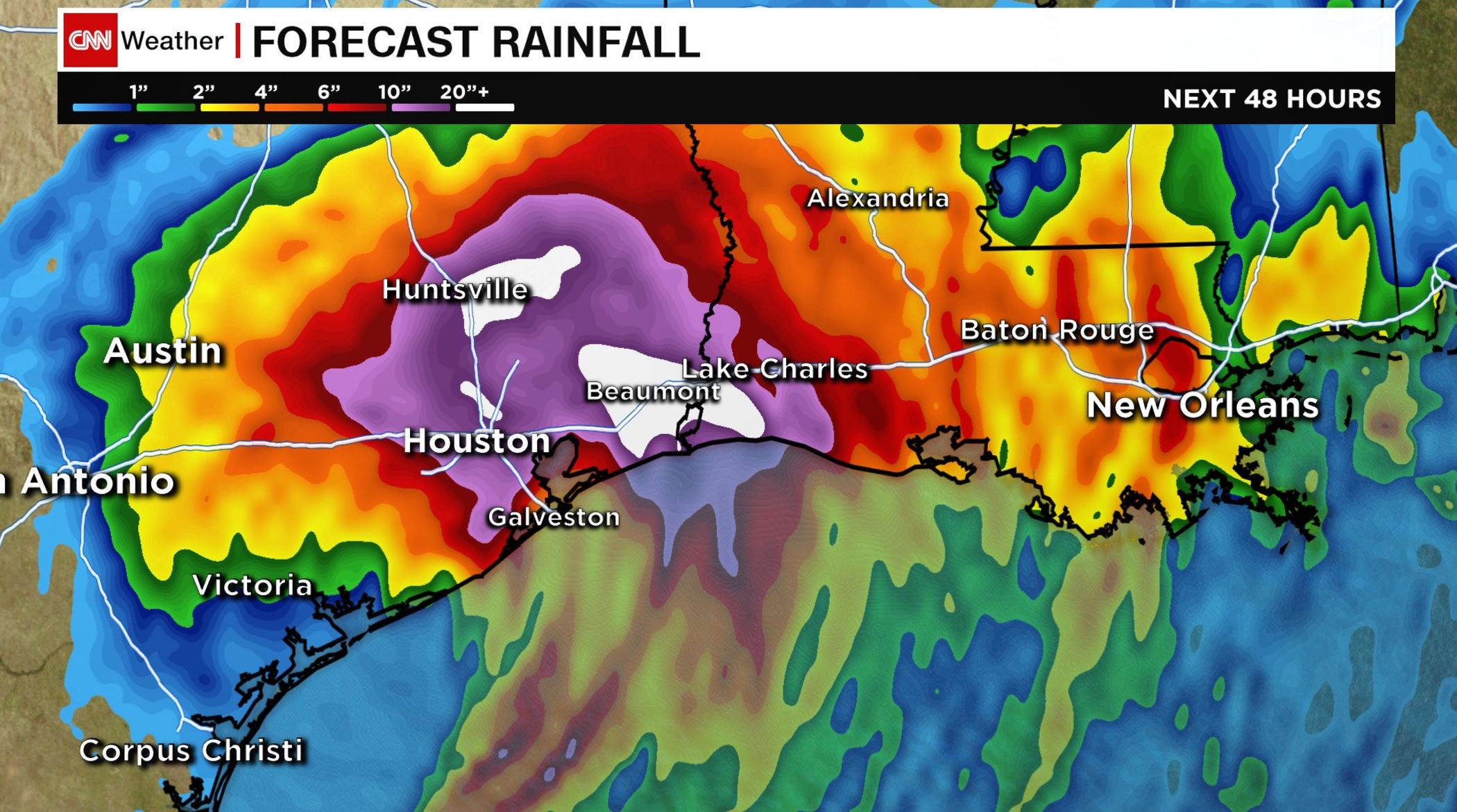
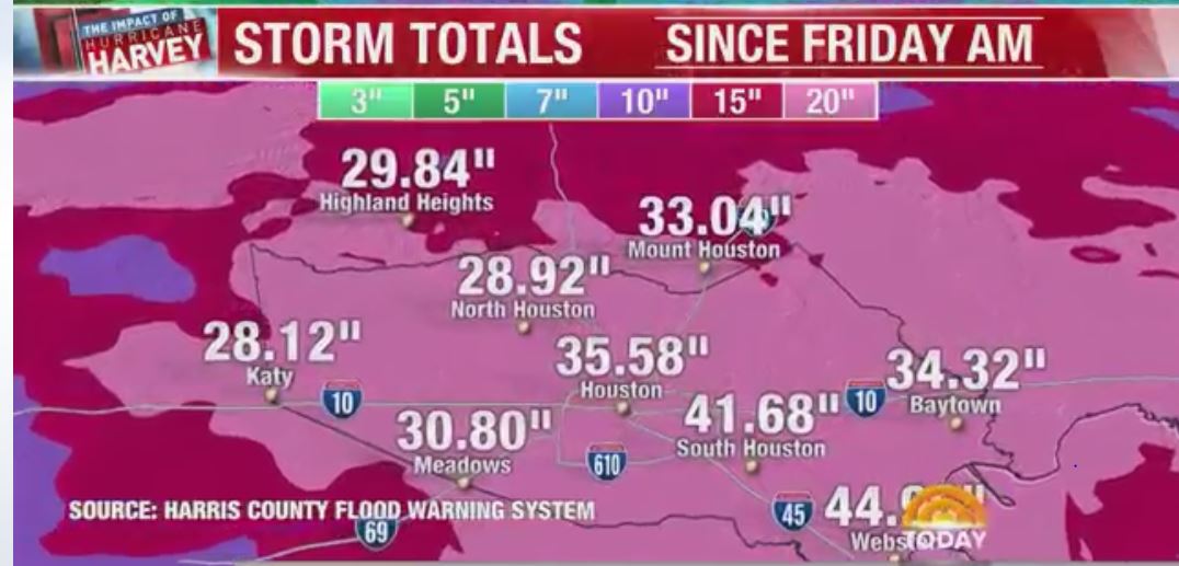
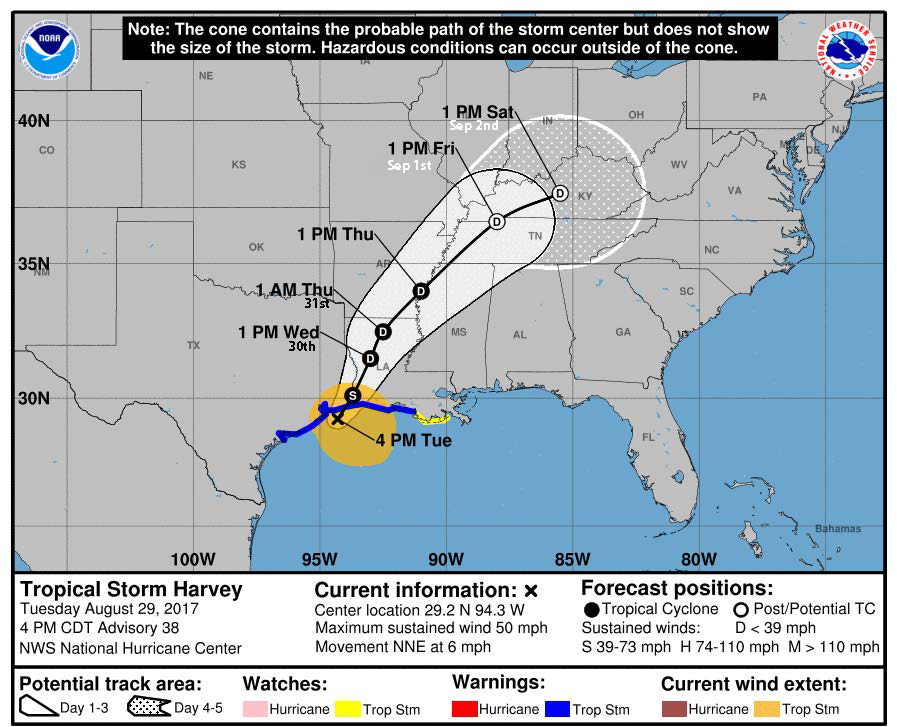
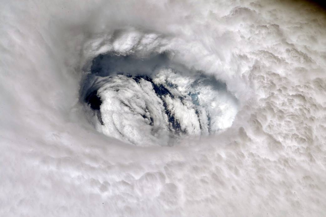
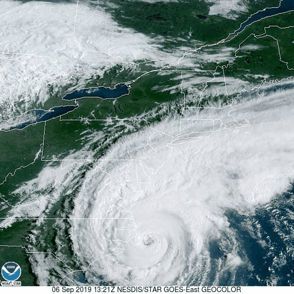
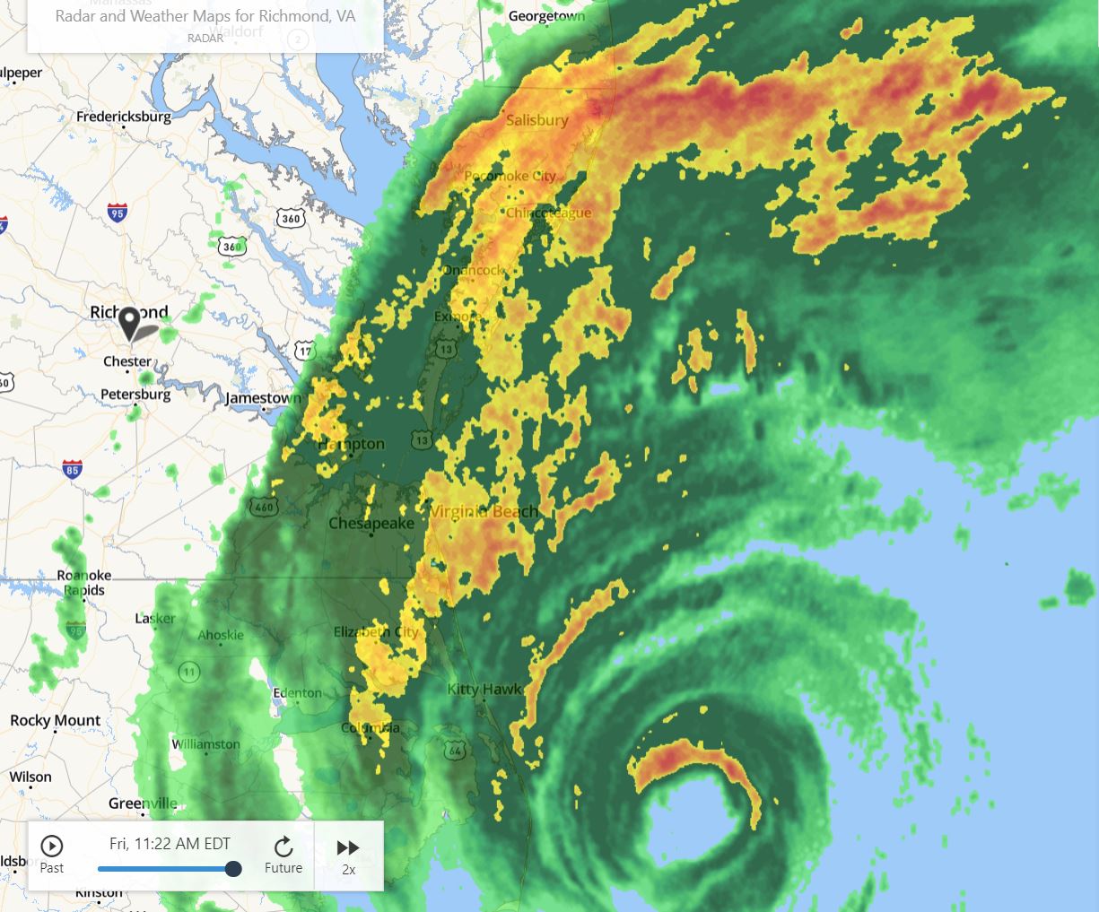
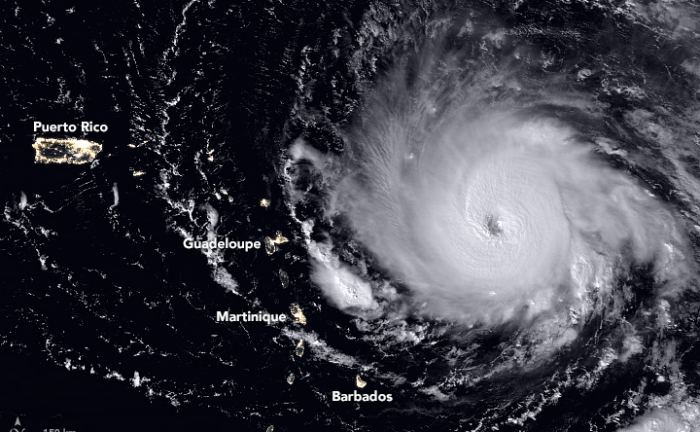
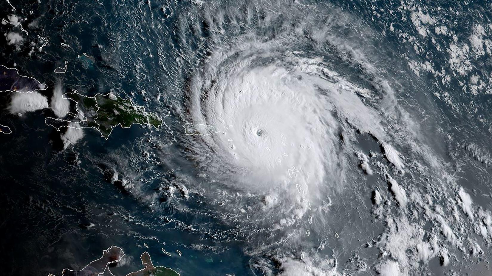
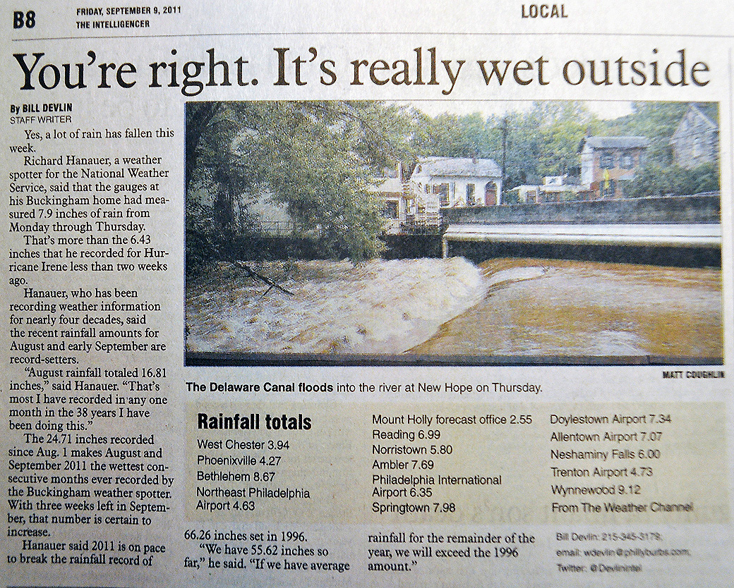
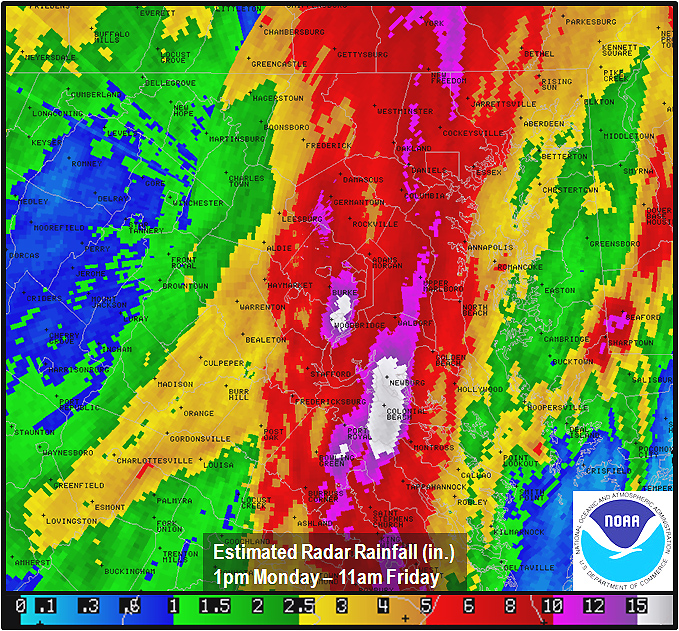
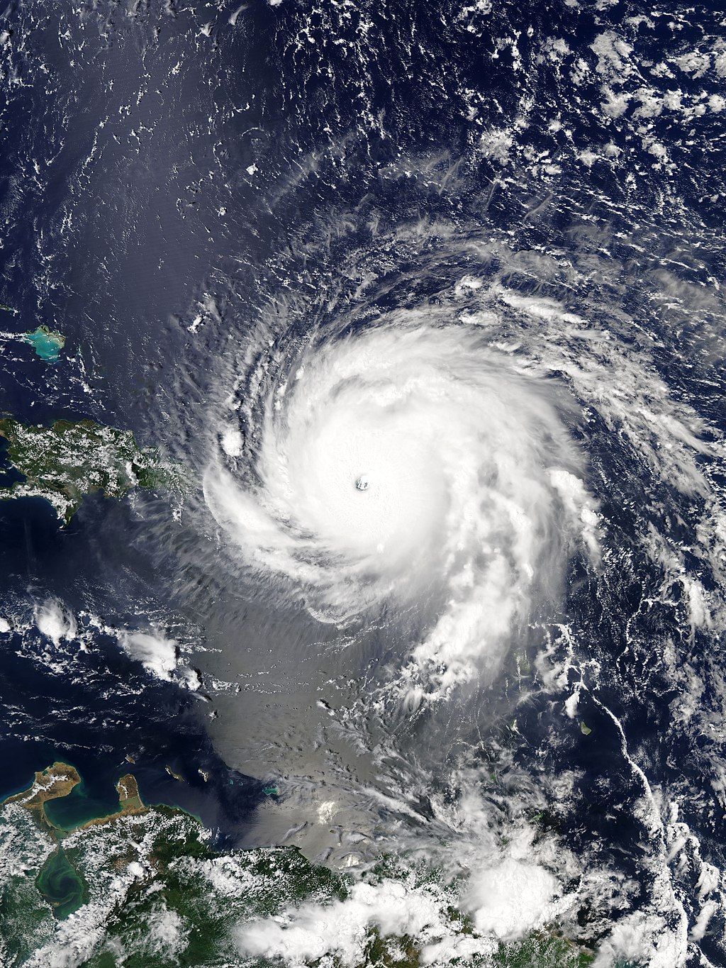
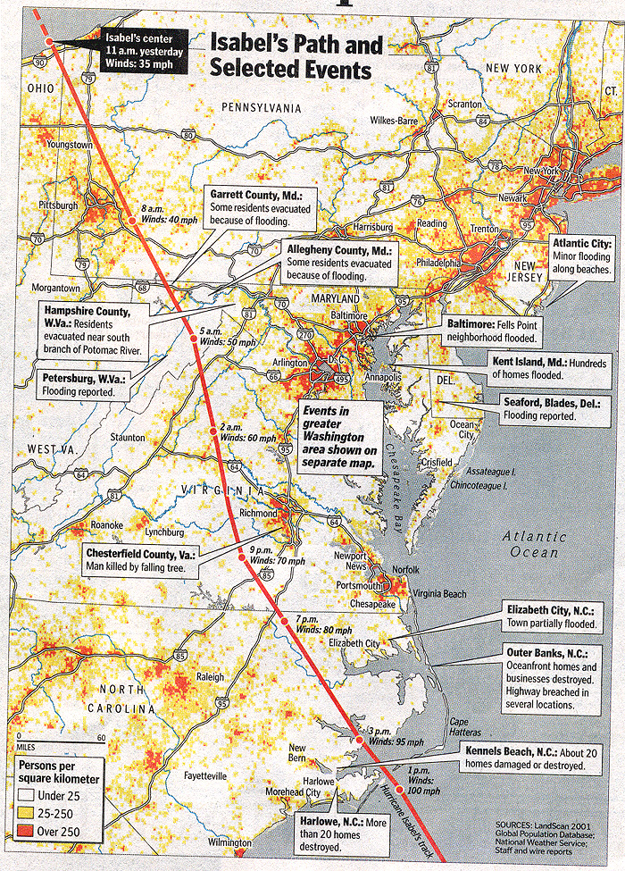