|
AUGUST  01ST 1812 A tornado struck parts of Westchester County, New York. The same storm today would have caused major destruction. (Ref. AccWeather Weather History) 1861 Don't take criticism to seriously!! Captain Robert Fitz-Roy initiated a daily weather forecast for the following day for several regions of England. The service was well received by the public, but people in scientific circles criticized the effort saying that it lacked scientific merit. Fitz-Roy used data telegraphed the Meteorological Department in London from 15 stations across the country each morning. Disturbed by the criticism, Fitz-Roy killed himself less than four years later. (Ref. Wilson Wx. History) 1917 80 forest fires ,were ignited in Trinity County, California when an electrical storm produced hundreds of lightning bolts over a small area which was tinder-box dry from severe drought. (Ref. AccWeather Weather History) 1947 What turned out to be the hottest August on record started off on a decidedly cool note across parts of Michigan with record lows at: Houghton Lake, MI: 32°, Ste. St. Marie, MI: 36°, Muskegon, MI: 43°, Flint, MI: 43° and Grand Rapids, MI: 48 °F. (Ref. Wilson Wx. History) 1954 Mount Rainier in Washington State was still covered with sixteen inches of snow at the 5500 foot level following a big snow season. (David Ludlum) 1966 Very strong winds from severe thunderstorms struck northwest Oklahoma. Winds gusted to 80 mph in Laverne, and blew a parked Cessna aircraft through a fence and into a ditch. As the storms approached Gage, winds gusted to 92 mph, causing blowing dust that reduced the visibility to near zero. (Ref. Wilson Wx. History) 1972 This was the first of 25 straight days without measurable rain at Philadelphia, PA. (Ref. AccWeather Weather History) 1974 Georgia--An 18-year-old youth was killed by lightning at a lumber camp on the Ocmulgee River. Maine--One person was killed by lightning at Fort Fairfield. Aroostook County. No further details. (Ref. Lightning-The Underrated Killer.pdf) 1976 Flight operations at the former Stapleton Airport in Denver, CO were suspended for 90 minutes when the airport tower radar was knocked out and water reached a foot deep on some taxi ramps after 1.50 inches of rain fell in one hour. Record lows gripped Wisconsin including Green Bay, WI: 45°, Madison, WI: 47°, La Crosse, WI: 49° and Milwaukee, WI: 49°. (Ref. Wilson Wx. History) 1978 A severe thunderstorm developed in Beadle County, South Dakota during the afternoon and plunged southeastward. Winds up to 80 mph and hail the size of golf balls pelted the area. The hail piled up to six inches deep on roads and to three feet in the ditches. So much hail fell that it remained on the ground in some areas for 36 hours after the storm. Approximately 480,000 acres of nearly ripe crops were badly damaged or completely destroyed. Damage to crops and personal property was estimated at $4 million dollars. Over 35 inches of rain fell in the Hill Country northwest of San Antonio, TX between 7/31 and 8/4 as the remnants of Tropical Storm Amelia stalled. (Ref. Wilson Wx. History) 1980 The relentless heat from the summer of 1980 continued. Record highs included: Wichita, KS: 110°, Oklahoma City, OK 108°, Columbia, MO: 108°, Topeka, KS: 107°, Dodge City, KS: 106°, Little Rock, AR: 105°, St. Louis, MO: 104° and Springfield, MO: 103°. (Ref. Wilson Wx. History) 1983 A THUNDERSTORM HITS ANDREWS AIR FORCE BASE GIVING 149.5 MPH WINDS. The peak gust was recorded at 1411 - 7 minutes after Air Force One, with the President on board, landed on the same runway as the microburst was recorded! According to newspaper reports, Air Force One, with President Reagan on board, landed at 1404 EDT on the dry runway. A study headed by Fujita documented a near mishap at Andrews on Aug. 1, 1983. Ground-based wind measurement instruments called anemometers documented the pattern of high gusts of wind from the west-northwest, followed by calm conditions and then high gusts coming from the east-southeast. Trees were uprooted and three-quarters of an inch of rain fell. The roof of a building on the base was partially torn off by the winds. Besides monitoring airport runways for microbursts, Fujita suggested that the helicopter route between the White House and Andrews be monitored because helicopters are especially vulnerable to microbursts. How strong can thunderstorm winds be without a tornado?" The actual recorded amount to this date (2011) is this 1983 event with 149.5 MPH wind gust. (The Downburst by T. Theodore Fjuita-Professor at University of Chicago, pages 107-08) 1985 A nearly stationary thunderstorm deluged Cheyenne, WY with rain and hail. Six inches of rain fell in six hours producing the most damaging flash flood of record for the state. Two to five feet of hail covered the ground following the storm, which claimed twelve lives, and caused 65 million dollars property damage. (Storm Data) 1986 A powerful thunderstorm produced 100 mph winds and large hail in eastern Kansas and southwestern Missouri causing 71 million dollars damage, and injuring nineteen persons. It was one of the worst thunderstorms of record for Kansas. Crops were mowed to the ground in places and roofs blown off buildings along its path, 150 miles long and 30 miles wide, from near Abilene to southeast of Pittsburg. (The Weather Channel) 1987 Record heat gripped parts of the Midwest. A dozen cities reported record high temperatures for the date, including Lincoln, NE with a reading of 105 degrees, Moline, IL with an afternoon high of 103 degrees, and Burlington, IA with a reading of 102 degrees. (The National Weather Summary) 1988 Two-dozen cities in the Upper Midwest reported record high temperatures for the date, including La Crosse, WI with a reading of 105 degrees. Highs of 103° at Milwaukee, WI and South Bend, IND were records for the month of August. (The National Weather Summary) 1989 Hurricane Chantal made landfall along the Upper Texas coast about sunrise. Chantal deluged parts of Galveston Island and southeastern Texas with 8 to 12 inches of rain. Unofficial totals ranged up to twenty inches. Winds gusted to 82 mph at Galveston, and reached 76 mph in the Houston area. Tides were 5 to 7 feet high. The hurricane claimed two lives, and caused 100 million dollars damage. (The National Weather Summary) (Storm Data) 1993 The Great Midwest Flood continued as the flood stage reached 49.58 feet at St. Louis, MO; nearly 20 feet above flood stage, breaking the record set just days earlier. The peak flow rate was about 1.08 million cubic feet per second. At this rate, Busch Stadium would have been filled to the brim in just 69 seconds. A fast-food restaurant moored along the waterfront broke away and floated down the Mississippi River where it slammed into the Interstate 55-70 Bridge. A severe storm in Kent County, Michigan produced grapefruit-sized hail in Cannon Township, northeast of Grand Rapids. Palm Springs, CA tied their all-time record high with 123° (7/10/1979, 7/28/1995 & 7/29/1995). San Francisco, CA hit 98°, the hottest ever recorded for the city in August. Yuma, AZ and Tucson, AZ set daily record highs with 117° and 112° respectively. (Ref. Wilson Wx. History) 1997 It was the earliest date in summer that a temperature reading below 50° had ever been recorded at Asheville, NC when the temperature dropped to 49°. The previous earliest was 8/5/1985. Other record lows included: Bristol, TN: 51°, Lynchburg, VA: 51°, Dulles Airport, VA: 54 °F. (Ref. Additional Temperatures Listed On This Link) (Ref. AccWeather Weather History) 1998 A record 220,000 lightning bolts were recorded in the United States on this date. The usual number on summer days is about 100,000. (Ref. Wilson Wx. History) 1999 Suffolk, VA several homes were struck by lightning and at least two people were injured. (Ref. Lightning - Virginia Weather History) 2011 I was hit by lightning in August 2011 but apparently not a direct hit. I'm a little confused on how I was hit. I am a 45 year old male in average condition. The family has a history of heart problems. I had a physical a few weeks ago and didn't have any major issues. Blood pressure is good without medication. Read the full story at the following Ref. (Ref. A Lightning Survivor) |
|
AUGUST 02ND 1944 A hurricane formed in the Bahamas and came ashore at the North Carolina/South Carolina border. It moved north as a tropical storm, then curved to the northeast, passing across the lower Delaware Bay on its way out to sea. Philadelphia, PA received 2.39 inches of rain and 0.22 inches on the 3rd. This was the first of three tropical systems to affect the Mid Atlantic states in 1944. (Ref. Wilson Wx. History) 1945 Washington, DC had 3.39 inches rain in 3 hours, 4.26 inches in 6 hours and 5.18 inches in 12 hours. (Ref. Washington Weather Records - KDCA) 1954 Severe thunderstorms produced golf ball size hail for thirty minutes in north central Kansas. One drift of hail measured 200 feet long, seventy feet wide and three feet deep. (The Weather Channel) 1964 Muskegon, Michigan records its hottest day ever with a reading of 99 °F. (Ref. WxDoctor) 1970 At least eight people drowned on Florida Panhandle beaches due to the effects of Hurricane Celia which passed hundreds of miles to the south and made landfall near Corpus Christi, TX. Rip tides and heavy surf with waves up to 10 feet pounded the beaches of Escambia, Okaloosa and Santa Rosa Counties. The Escambia County Sheriff reported 25-30 emergency calls with lifeguards rescuing at least 12 people. (Ref. Wilson Wx. History) 1974 25 miles east of Buffalo, Wyo.--Lightning struck a party of fishermen, killing one and injuring four others. (Ref. Lightning-The Underrated Killer.pdf) 1975 Record heat gripped New England. Providence, RI had a maximum of 104 degrees and set a new state record maximum temperature. Chester, MA and New Bedford, MA both had a maximum temperature of 107 °F and established the state record for Massachusetts. The heat along the coast of Maine was unprecedented, with afternoon highs of 101 degrees at Bar Harbor and 104 degrees at Jonesboro. The state record for Main is 105 °F set in North Bridgetonin 1936. (The Weather Channel) (Ref. Lowest and Highest Temperatures for the 50 States) Boston, Massachusetts had a 102 °F temperature the warmest temperature for August. (Ref. NOAA Boston Weather Events) Residents of Hutchinson, Turner, and Minnehaha Counties in South Dakota were cleaning up from the previous night’s heavy rains. The 4.59 inches that fell at Sioux Falls is the official 24 hour precipitation record for the city. (Ref. Wilson Wx. History) 1978 Very heavy rains of 12 to 14 inches fell across the Texas Hill Country during the nighttime and early morning hours causing severe flooding on the Guadalupe River. Up to 30 inches of rain fell during the 3-day period from the 1st through the 3rd. 27 people died in the Hill Country flooding along with tens of millions of dollars in damage. More flooding occurred during the early evening near Abilene, where six people were killed. (Ref. Wilson Wx. History) 1980 The intense heat wave continued in Texas. Dallas had their 41st consecutive day of 100° readings. The streak eventually reached 42 days. Abilene, TX was on their 41st consecutive day of 98° or higher, tying a record that dated back to 1952. El Paso, TX was on their 51st consecutive day of 100°+ temperatures. Other record highs included: Oklahoma City, OK: 110°, Tulsa, OK: 108° and Springfield, MO: 102°. (Ref. Wilson Wx. History) 1985 Delta Air Lines Flight 191 was an airline service from Fort Lauderdale, Florida's Fort Lauderdale-Hollywood International Airport, bound for Los Angeles International Airport in Los Angeles, California, by way of Dallas-Fort Worth International Airport. On the afternoon of August 2, 1985, Delta Air Lines flight 191 crashed while on a routine approach to the Dallas-Fort Worth International Airport, killing 8 of 11 crew members and 126 of the 152 passengers on board and one person on the ground: a total of 135 deaths. This accident is one of the few commercial air crashes in which the meteorological phenomenon known as microburst-induced wind shear was a direct contributing factor. (Ref. This gives a detail account of this microburst disaster from Wikipedia.org) 1987 Hot weather continued in the central U.S. Fifteen cities reported record high temperatures for the date, including Concordia, KS with a reading of 106 degrees, and Downtown Kansas City, MO with a high of 105 degrees. Evening thunderstorms produced severe weather in the Ohio Valley and the north central U.S. Thunderstorms in South Dakota produced wind gusts to 70 mph at Philip, and hail two inches in diameter at Faulkton. (Storm Data) (The National Weather Summary) 1988 Searing heat continued from the Middle and Upper Mississippi Valley to the Middle and Northern Atlantic Coast States. Twenty- six cities reported record high temperatures for the date. Chicago, IL reported a record seven days of 100 degree heat for the year. (The National Weather Summary) 1989 Low pressure representing the remains of Hurricane Chantal deluged north central Texas with heavy rain. Up to 6.50 inches drenched Stephens County, and Wichita Falls reported 2.22 inches of rain in just one hour. Bismarck, ND reported a record warm morning low of 75 degrees, and record hot afternoon high of 101 degrees, and evening thunderstorms in North Dakota produced wind gusts to 78 mph at Lakota. Early evening thunderstorms in Florida produced high winds that downed trees at Christmas. (Storm Data) (The National Weather Summary) 1995 Hurricane Erin made landfall near Sebastian Inlet in southern Brevard County during the early morning hours. Brevard County bore the brunt of the storm with wind gusts to 100 mph between Melbourne Beach and Cocoa Beach knocking down trees on houses, cars, and power lines. As Erin moved through Orlando during the morning wind gusts to 60 mph downed trees on power lines, houses and cars. About one-half million people were without power initially, several thousand were without power for more than five days. Heavy rains of up to 8 inches in three hours on the backside of Erin hit Brevard County again during the afternoon causing widespread flooding of low lying areas. Erin moved into the Gulf of Mexico during the afternoon as a tropical storm, but regained hurricane strength. Erin then made a second Florida landfall near Pensacola on the morning of the 4th with sustained winds of 95 mph gusting to 110 mph. Damage in the Pensacola area was estimated at $300 million dollars. (Ref. Wilson Wx. History) 1996 Powerful thunderstorms moved across southwest and south central Kansas during the evening hours. In Pratt county eight train cars were blown off the tracks while the train was moving. This occurred one mile west of Cullison. One family was nearly run over by the derailing train cars. One boxcar ended up about 10 feet away from their vehicle. From three miles south of Lewis to Belpre, very strong thunderstorm winds killed calves, blew cars off the highway and blew down 60 power poles. There were unofficial and unconfirmed reports of 125 mph winds recorded on home stations. (Ref. Wilson Wx. History) 2000 Massive downburst winds estimated at 90 to 110 mph hit areas from eight miles west of Spearfish, SD to several miles east of Spearfish. Hail, to golf ball size accompanied the high winds and damaged roofs and siding throughout the region, although the winds caused the worst damage. The airport at Spearfish had 27 planes damaged, and seven of those were destroyed beyond repair. Seven hangers at the airport were also damaged or destroyed. Roofing material sliced through an oxygen valve at the Spearfish Trout Farm and killed 100,000 out of 120,000 trout that the family raised. In the Spearfish city campground, more than 150 campers were there, in anticipation of the 60th Annual Sturgis Motorcycle Rally the following week. None of the trees fell on occupied tents, although several fell within inches of where people were sleeping in their tents. In Rapid City, the National Weather Service office measured wind gusts of 70 mph. The storm weakened as it moved southeast of Rapid City, but was still at severe limits as it passed over the Badlands National Park and went southward into Bennett County. Observers in Martin reported 60 mph wind gusts. (Ref. Wilson Wx. History) 2001 Chicago Illinois was pounded by up to 3.50 inches of rain in one hour in the a.m. rush; some interstate expressways were under 8 feet deep water. Some 228 stalled vehicles had to be towed. 10,000 homes had water damage; 50,000 customers without power at the peak of the storm. (Weather Guide Calendar with Phenomenal Weather Events 2007 Accord Publishing, USA) (Ref. WxDoctor) 2002 Lightning hit the chimney of a home in NJ’s South Brunswick Township. Its impact and resulting thunder’s concussion “blew out” the glass fireplace; the den/dining room were sprayed with glass fragments. A woman in the house was hurt when knocked down by the event. (Weather Guide Calendar with Phenomenal Weather Events 2011 Accord Pub. 2010, USA) 2008 Denver, Colorado: A 130-year-old high-temperature record falls in Denver, when the mercury hit 103 °F. (Ref. WxDoctor) Severe thunderstorm produced 87 mph wind gust at Miles City, MT just before midnight. There were numerous reports of wind damage including car windows blown out. (Ref. Wilson Wx. History) |
|
AUGUST 03RD 1864 A waterspout over Albemarle Sound, NC passed perilously close to the Union Fleet at anchor. The crews of the ships watched "in awe" as the whirlwind dissipated as it moved onshore. (Ref. Wilson Wx. History) 1885 A tornado causing estimated F3 damage hit Philadelphia and Camden along its eight-mile path. Six people were killed and damage totaled $500,000 dollars. Other tornadoes causing estimated F2 damage touched down in Cecil County, Maryland, New Castle County, Delaware and Bucks & Chester Counties in Pennsylvania. (David Ludlum) 1894 After two record heat waves in July, record cool weather arrives. Lansing, MI fell to 32° for a rare summer freezing temperature. (Ref. Wilson Wx. History) 1898 Philadelphia, PA had one of their worst thunderstorms ever when 5.84 inches fell in just 2 hours. The hydraulic pressure in the city sewers caused by the force of the accumulated runoff created overflows via toilets, basins, and sinks to rise to second floor levels in some cases. (Ref. AccWeather Weather History) 1899 A tropical depression was born in the tropical Atlantic. Before it finally dissipated a record 33 days later, it became known as the San Ciriaco Hurricane after a Puerto Rican village the storm devastated. Its life as a hurricane was 27.75 days, a record for the Atlantic Basin beating Hurricane Ginger of 1971 by three-quarters of a day. (Ref. Wilson Wx. History) 1960 A home in Wauponsee Township, IL was struck by two tornadoes within 4 hours. The first one struck around 7 PM and the second around 11 PM. The house sustained significant damage to the roof, wiring and appliances. (Ref. AccWeather Weather History) 1964 Muskegon, MI set an August record and tied their all-time record high temperature at 99°. The temperature hit 100° at Grand Rapids, MI a record for the date. Owen, WI set their all-time record high with 101°. (Ref. AccWeather Weather History) 1970 Hurricane Celia struck the coast of Texas producing wind gusts to 161 mph at Corpus Christi, and estimated wind gusts of 180 mph at Arkansas Pass. The hurricane was the most destructive of record along the Texas coast causing 454 million dollars damage, and also claimed eleven lives. (David Ludlum) (The Weather Channel) (Ref. WxDoctor) (Ref. More Information About Hurricane Celia) (Ref. AccWeather Weather History) 1974 Brooklyn, CT -- Lightning struck and killed a youth when he was running from a tent toward home at 2:40 a.m. (Ref. Lightning-The Underrated Killer.pdf) 1975 Boston, Massachusetts had a 83 °F temperature the warmest minimum temperature. (Highest minimum on Boston's records) (Ref. NOAA Boston Weather Events) 1980 12 inches of rain fell in six hours at Buffalo, NY causing extensive flash flooding. (Ref. AccWeather Weather History) 1981 Severe thunderstorms tore across portions of central and eastern South Dakota. Near Hoven, a steel bin building was lifted off the ground by a small tornado and carried about 30 feet before it wrapped around a tree. In Faulkton, winds gusted to 97 mph at the Faulkton airport. The extremely high winds destroyed an airport hanger and damaged a grain elevator. At Redfield, 70 mph winds leveled an outdoor movie screen and flipped a plane. (Ref. Wilson Wx. History) 1986 The minimum temperature of 69° is first below 70 °F recorded in the past 28 days at DCA. (Ref. Washington Weather Records - KDCA) 1987 A severe thunderstorm moved across Cheyenne, WY during the mid afternoon. The thunderstorm produced hailstones up to two inches in diameter causing more than 37 million dollars damage. The eastern U.S. sweltered in the heat. A dozen cities reported record high temperatures for the date, including Paducah, KY with a reading of 102 degrees. Beckley, WV established an all- time record with an afternoon high of 93 degrees. (Storm Data) (The National Weather Summary) 1988 Thunderstorms developing ahead of a slow moving cold front produced severe weather from the Central High Plains to the Upper Great Lakes Region. Thunderstorms around Fort Collins, CO produced wind gusts to 74 mph along with marble size hail. Sixteen persons were injured in the storm, most of whom were accidentally locked out of their office building, having evacuated it when the fire alarm went off, apparently triggered by lightning. Elkader, IA recorded their hottest August temperature with 106°. (Storm Data) (The National Weather Summary) 1989 Thunderstorms representing what remained of Hurricane Chantal drenched Wichita, KS with 2.20 inches of rain in four hours during the early morning. Thunderstorms developing in Minnesota produced wind gusts to 85 mph at Baudette during the afternoon, and softball size hail at Lake Kabetogama, during the evening. Jamestown, ND reported a record hot afternoon high of 103 degrees. (Storm Data) (The National Weather Summary) 1993 Chesterfield County, VA lightning struck and killed a 30-year-old man as he mowed his lawn. (Ref. Lightning - Virginia Weather History) Workers desperate to save the historic town of Prarier du Rocher, IL during the Mississippi River Flood deliberately broke a 1,000 foot hole in a levee near the town to divert water headed toward the town from a levee break upstream. The quick action worked, saving the town. (Ref. Wilson Wx. History) 1994 Fairbanks, AK recorded their hottest August temperature ever with 93°. (Ref. AccWeather Weather History) 1995 Hurricane Erin was nearing the coast of the Florida Panhandle. The hurricane had emerged into the Gulf Mexico the previous day after crossing the Florida Peninsula. By early morning, Erin's sustained winds reached 100 mph in a small area near its center. A 98-mph wind gust was observed at Mary Esther Field and Fort Walton Beach, FL. The storm came ashore near Pensacola, FL later that morning causing six fatalities and an estimated $700 million damage. The barrier island stretching from Pensacola Beach to Navarre Beach absorbed the brunt of the storm as it came ashore near Pensacola. Sustained winds of 94 mph and gusts up to 103 mph were measured at Pensacola during the height of the storm. Seven people were reported missing at sea. South Bend, IN was deluged with 4.83 inches of rain in 24-hours to set their record for greatest daily rainfall. It was certainly more like fall at Shirley Basin, WY when they recorded a morning low temperature of 33°. (Ref. Wilson Wx. History) 1996 Be off the mountain by noon in storm season. At Potato Lake (SSW of Silverton, Co), a woman and 3 children were hit by lightning at 1:20 P.M. while sheltering under a tree; all had first degree burns (8-yr-old needed resuscitation). They survived; the family dog did not. (Weather Guide Calendar with Phenomenal Weather Events 2011 Accord Pub. 2010, USA) 2002 Two campers at Natural Chimneys Regional Park in Augusta County, VA were struck and injured by lightning. (Ref. Lightning - Virginia Weather History) 2003 Severe thunderstorms moved over parts of the Chicago Metro area during the early afternoon. The storms produced golf ball size hail along with heavy rain and flooding. 4.14 inches was reported in just 90 minutes six miles east of O’Hare Airport. Four to six feet of water covered the closed Kennedy Expressway. Several tents were blown down at an outdoor festival in Roselle. These storms continued into the evening producing more large hail. The National Weather Service at Romeoville reported nickel size hail for five minutes and 1.60 inches of rain in just 30 minutes. (Ref. Wilson Wx. History) 2008 A lightning bolt struck an auto-racing track in Flisa, Norway about five miles from the Swedish border sending 45 fans to hospital with minor burns. (Ref. Wilson Wx. History) 2009 On 3 August 2009, the ad-hoc State Climate Extremes Committee (SCEC) voted unanimously to approve a new hail stone record for the state of Vermont. The NCDC approved the decision of the SCEC and recognize the 3.3 inch diameter, 6.8 inch circumference, 2.1 ounce hail stone which fell near Westford, VT on the evening of 16 July, 2009. Record Size Hail for Vermont - NWS A woman riding her bike in training for the Ironman Triatholon was struck by lightning in Boulder, CO. She was in the 78th mile of a 100 mile training ride when she was struck. The woman lost her vision initially and couldn’t move her arms. After a short stay in the hospital, she made a complete recovery. (Ref. Wilson Wx. History) |
|
AUGUST 04TH 1609 Sir Thomas Gates, future governor of Virginia, was on his way to England from Jamestown. On Saint James Day, while between Cuba and the Bahamas, a "most terrible and vehement storm" raged for 44 hours. One of the small vessels in the fleet sank to the bottom of the Florida Straits. Four of the remaining vessels reached Virginia soon after the storm...followed a few days later by three other ships. The flagship, known as Sea Adventure, disappeared and was presumed lost. A small bit of fortune befell the ship and her crew when they made landfall on Bermuda. Although the vessel was damaged on a surrounding coral reef, all survived and spent ten months on the unsettled isle. The Spaniards, though shipwrecked on the island many times, had failed to colonize there. The British claimed the island and quickly settled the subtropical isle. In May 1610, they set forth for Jamestown, this time arriving at their destination. This near catastrophe provided the inspiration and background for William Shakespeare's play, The Tempest. (Ref. The Tempest) 1666 A violent hurricane raked the island of Guadeloupe. Every boat on its coast was dashed to bits, including a 17 ship fleet with 2,000 troops that sank. The island's batteries, with walls 6 feet thick, were destroyed, and the large cannons washed away. (Ref. AccWeather Weather History) 1882 A vivid aurora was visible from Oregon to Maine, down the east coast as far as Mayport, FL, and inland as far as Wellington, KS. Observers at Louisville, KY noted "merry dancers" across the sky, and observers at Saint Vincent, MN noted it was probably the most brilliant ever seen at that location. (The Weather Channel) (Ref. WxDoctor) 1915 Tropical storm from the North Bahamas moved over the Washington, DC area on a northeast track gave 2.34 inches of rain and winds to 46 mph from the SE. (Ref. Washington Weather Records ) 75 people died in flooding at Erie, PA. Many streets were flooded and bridges washed away. (Ref. AccWeather Weather History) 1930 The temperature at Moorefield, WV soared to 112 degrees to establish a state record, having reached 110 degrees the previous day. Widespread drought after April of that year caused some towns to haul water for domestic use, and many manufacturing plants were barely operational. (The Weather Channel) (Ref. Additional Temperatures Listed On This Link) 1961 Spokane, WA reached an all-time record high of 108 degrees. Kalispell, MT set an all-time record with a reading of 105 degrees. (The Weather Channel) (Ref. Additional Temperatures Listed On This Link) (Ref. AccWeather Weather History) 1980 A record forty-two consecutive days of 100° heat finally came to an end at the Dallas-Fort Worth Airport. July 1980 proved to be the hottest month of record with a mean temperature of 92 degrees. There was just one day of rain in July, and there was no measurable rain in August. There were 18 more days of 100° heat in August, and four in September. Hot weather that summer contributed to the deaths of 1200 people nationally, and losses from the heat across the country were estimated at twenty billion dollars. (David Ludlum) (The Weather Channel) 1981 This was a day to remember in portions of south central South Dakota as an unusually long lived thunderstorm wind event hit the area. In St. Francis a radio station reported a gust of 86 mph, but that was only the beginning. For the next 20 minutes winds of 50 to 70 mph hammered the area doing massive damage to trees and a few trailers in the area. (Ref. Wilson Wx. History) 1982 The low temperature at Billings, MT was 60°. This began a string of 19 consecutive days on which the low temperature did not drop below 60°, the record longest such streak in August. (Ref. Wilson Wx. History) 1987 A cold front brought relief from the heat to a large part of the Midwest, while hot weather continued in the south central and eastern U.S. Morning thunderstorms in Nebraska deluged the town of Dalton with 8.71 inches of rain, along with hail three inches in diameter, which accumulated up to four feet deep near the town of Dix. (Storm Data) (The National Weather Summary) 1988 Thunderstorms produced severe weather from eastern Iowa to Lower Michigan during the afternoon and evening hours, producing golf ball size hail and spawning several tornadoes. A thunderstorm at Maquoketa, IA produced wind gusts to 75 mph. (Storm Data) (The National Weather Summary) A hot and dry summer continues with record highs of 96° at Lansing and Grand Rapids, MI and 92° at Muskegon, MI. (Ref. Wilson Wx. History) 1989 Thunderstorms produced severe weather from eastern Nebraska and northeastern Kansas to the Great Lakes Region, with 150 reports of large hail or damaging winds during the afternoon, evening, and nighttime hours. Thunderstorms produced tennis ball size hail at Claremont, MN, and wind gusts to 75 mph at Milwaukee, WI. Thunderstorms representing what once was Hurricane Chantal produced five inches of rain at Grant, MI, and deluged Chicago, IL with more than three inches of rain in three hours. (Storm Data) (The National Weather Summary) 1992 A DC-10 flying from Denver, CO to Minneapolis, MN was struck by lightning in flight and suffered some structural damage and damage to the plane's avionics. Fortunately, the plane managed to land safely. (Ref. Wilson Wx. History) 1994 Boston, Massachusetts had 16 days from July 20 to August 4 giving the greatest number of days with temperatures of 70 degrees or above. (Ref. NOAA Boston Weather Events) 1995 Thunderstorms over northwest Iowa storms grew quickly, producing golf ball to baseball size hail over Palo Alto County near Ayrshire and Webb. As the storms moved south, a copious amount of hail was dropped. Just north of Rush Lake in Palo Alto County, pea-sized hail covered the ground to a depth of 12 inches. The storms then moved into northern Pocahontas County where they dropped softball size hail, which has a diameter of 4.50 inches, just north of Laurens. Golf ball size hail also continued to fall over Pocahontas County near the communities of Pocahontas and Havelock. The storms weakened a bit as they moved into Sac and Calhoun Counties. Crop damage totaled about $335,000 from these storms. Record heat prevailed across parts of the East. Record highs included: Philadelphia, PA: 98°, LaGuardia Airport (NYC), NY: 96°, Wilmington, DE: 96° and Bridgeport, CT: 93°. (Ref. Wilson Wx. History) 1998 College Station, Texas: The last of a string of 30 consecutive days with temperatures greater than 100 °F. 49 such days will be recorded in the blistering Summer of '98. (Ref. WxDoctor) Dallas, TX saw its streak of 29 consecutive days with temperatures 100° or hotter come to an end. It was the second longest streak of 100° plus days in the city's history. Record highs occurred across the southwest including Borrego Springs, CA: 116°, Redding, CA: 112°, Victorville, CA: 110°, Stockton, CA: 109°, Sacramento, CA: 108°, Riverside, CA: 106°, Escondido, CA: 99°, Idyllwild, CA: 96°, Palomar Mountain, CA: 95° and Big Bear Lake, CA: 88° and San Francisco (Airport), CA: 87°. (Ref. Wilson Wx. History) 2006 Washington DC: The temperature at Ronald Reagan National Airport reaches 101 °F the hottest ever for that day in the nation's capitol. (Ref. WxDoctor) 2008 A derecho blasted into Indiana and Illinois; The Chicago tornado sirens blared. The game at Wrigley Field between Cubs/Astros was stopped as player/fans told to take shelter. Passengers at O’Hare International Airport were evacuated to lower levels of buildings; 350+ flights canceled. (Weather Guide Calendar with Phenomenal Weather Events 2011 Accord Pub. 2010, USA) 2010 Cumberland, MD police officers responded to the popular hiker/biker trail near the Valley Street intersection after first being alerted to the incident at 6:14 p.m. Officers found the victim under an 18 to 20 inch diameter locust tree, immediately began to render aid and requested the city fire department and its emergency medical services personnel to respond. The victim was freed from beneath the tree and transported to the Western Maryland Regional Medical Center where she died of her injuries, said police. (Ref. Woman Biker Killed by Tree ) 2012 Third of the top ten weather events - Summer Heat Wave. June 22-August 4. Extreme heat that began over the High Plains, expanded to the Fast Coast, and then centered on the Heartland broke thousands of temperature records and resulted in July 2012 edging out July 1936 as the hottest month on record for the contiguous United States. The heat, which was blamed for over 100 deaths, contributed to the drought that affected much of the country. Top 2012 Weather Events (Ref.Weatherwise May/June 2013 volumn 66 /number3 page 17) 2020 Tropical Storm Isaias hit the eastern third of Virginia hardest on Tuesday morning during its brief but destructive journey up the Eastern Seaboard. Several hours of torrential rain flooded dozens of roads, while winds gusting past 45 mph downed trees and put hundreds of thousands of homes and businesses in the dark. The storm left scattered road closures and power outages in metro Richmond and more widespread disruption across the Tidewater region, where winds approached 70 mph. No serious damage was reported in the western half of the state. (Ref. The Richmond Times Dispatch) (Ref. The Richmond Times Dispatch) |
|
AUGUST 05TH 1843 A cloudburst at Chester Creek near Philadelphia, PA, gave 16 inches of rain in a three hour period. (Ref. AccWeather Weather History) A spectacular cloudburst near Philadelphia turned the small creeks and streams entering the Delaware River into raging torrents. As much as sixteen inches of rain fell in just three hours. Flooding destroyed thirty-two county bridges, and caused nineteen deaths. It is believed that several small tornadoes accompanied the torrential rains, one of which upset and sank more than thirty barges on the Schuylkill River. (David Ludlum) 1875 Several tornadoes moved across northern and central Illinois. One of the stronger tornadoes touched down in Warren County and 25 homes were destroyed, with 2 people killed and 15 injured. Another in a series of tornadoes touched down near Knoxville and moved east into northern Peoria County. 14 people were hurt and 20 farms destroyed by this family of tornadoes, described by eyewitnesses as looking like a "monstrous haystack". (Ref. Wilson Wx. History) 1904 Detroit Lakes woman is hit by lightning. It melted her hairpins and steel in corset but does not kill her. (Ref. AccWeather Weather History) 1915 Fort Wayne, IN set their coldest August high temperature with 60°. (Ref. Wilson Wx. History) 1924 The SS Frankenfels measured a sea-surface temperature of 96 degrees in the Persian Gulf. If not the highest sea-surface temperature reliably measured, it is certainly among the highest. (Weather Guide Calendar with Phenomenal Weather Events 2011 Accord Pub. 2010, USA) 1959 A 24 hour rainfall record for Iowa was set with 16.70 inches in Decatur County. (Ref. AccWeather Weather History) 1961 The temperature at Ice Harbor Dam, WA soared to 118 degrees to equal the state record established at Wahluke on the 24th of July in 1928. The afternoon high of 111 degrees at Havre, MT was an all-time record for that location but Montana's state record is 117 °F set in 1937 (The Weather Channel) (Ref. Lowest and Highest Temperatures for the 50 States) McAllen, Texas: McAllen sets a new record high on Wednesday when the temperature soars to 105 °F. McAllen has now set a new record high on all but one day so far this month. (Ref. WxDoctor) 1974 Fort Walton Beach, Fla.--Lightning struck an aluminum ladder at a construction project. The man on the ladder was killed, three nearby workmen were injured. (Ref. Lightning-The Underrated Killer.pdf) 1980 Hurricane Allen was one of the most intense hurricanes ever observed in the Atlantic. On this date, the hurricane reached Category 5 status for the first of three times during its long path across the Atlantic as reconnaissance aircraft measured a 911 millibars (26.90 inches of mercury) pressure in the eastern Caribbean while south of Puerto Rico. Later this day, Allen moved across Haiti, ruining much of the country's coffee crop and killing 220 people. Casper, WY established new record low of 39°; breaking the previous record by 9 degrees. (Ref. AccWeather Weather History) 1983 Very heavy thunderstorms hit the southern portion of metro Denver, CO. 2.89 inches of rain fell in just 38 minutes causing widespread street flooding in southeast Denver. Two feet of water covered a section of Interstate 25. Hail up to golf ball size accompanied the storm in Littleton and Englewood along with 60 mph winds. (Ref. AccWeather Weather History) 1987 Severe thunderstorms raked eastern South Dakota. The thunderstorms spawned half a dozen tornadoes, produced softball size hail at Bowdle, and produced wind gusts to 90 mph south of Watertown. Hot weather continued in eastern Texas. Afternoon highs of 100 degrees at Houston and 106 degrees at Waco equaled records for the date. (The National Weather Summary) (Storm Data) 1988 Thunderstorms produced severe weather from Indiana and Lower Michigan to Pennsylvania and New York State during the day. Thunderstorms in Michigan produced wind gusts to 80 mph at Ashley, Hastings and Lennon. (The National Weather Summary) (Storm Data) 1989 Thunderstorms produced severe weather in Oklahoma, and from Iowa to the Upper Ohio Valley, with 216 reports of large hail or damaging winds between early Saturday morning and early Sunday morning. Thunderstorms moving across Iowa around sunrise produced extremely high winds that caused ten million dollars damage to crops in Carroll and Greene Counties. Thunderstorm winds at Jefferson, IA reached 102 mph. Afternoon thunderstorms produced tennis ball size hail at Bay Mills, WI. (Storm Data) (The National Weather Summary) (Ref. More Information About This Storm) 1995 Near Deerfield, KS, hail piled in huge drifts and stripped corn in a two mile wide swath. Hail drifts were still evident 24 hours later. Rain of over six inches in a short time caused flash flooding in the Deerfield area. Highway 50 was covered by three feet of water and was closed for several hours and limited to one way traffic for 24 hours. Sand was deposited on many streets bringing out heavy equipment to clear the debris. (Ref. Wilson Wx. History) 1999 Governors of four Mid-Atlantic States imposed mandatory water restrictions as the worst drought in the history of the region continued. The period April through July ranked as the second driest ever for the Northeast, second only to 1965. (Ref. Wilson Wx. History) 2000 A wet microburst with winds estimated at 120 mph caused heavy damage in and around Mitchell, SD. Apartments and several mobile homes were destroyed, vehicles were overturned, and other damage occurred to buildings and vehicles. Widespread tree and power line damage also occurred. 10 people were injured, although the majority of the injuries were minor. The damage path was approximately a mile and a half long and a mile wide, extending over the southwest part of Mitchell. (Ref. Wilson Wx. History) 2002 Tropical Storm Bertha became the first tropical system of the 2002 Atlantic hurricane to make a U.S. landfall. Bertha dumped 7.15 inches of rain on Pascagoula, MS in 24 hours. (Ref. Wilson Wx. History) 2009 Calgary, Alberta Canada struggled to get above 50° mark with the light rain and drizzle. Rocky Mountain House, Canada was stuck in the upper 40s most of the day. (Ref. Wilson Wx. History) 2020 Tropical Storm Isaias hit the eastern third of Virginia hardest on Tuesday morning during its brief but destructive journey up the Eastern Seaboard. Several hours of torrential rain flooded dozens of roads, while winds gusting past 45 mph downed trees and put hundreds of thousands of homes and businesses in the dark. The storm left scattered road closures and power outages in metro Richmond and more widespread disruption across the Tidewater region, where winds approached 70 mph. No serious damage was reported in the western half of the state. (Ref. The Richmond Times Dispatch) (Ref. The Richmond Times Dispatch) |
|
AUGUST 06TH 1881 Smoke from Michigan forest fires created a yellow pall over the Northeast. Candles were necessary for light at noontime. (Ref. AccWeather Weather History) 1890 Thunderstorms left four inches of hail covering the ground in Adair County and Union County in Iowa. The hail drifted into six foot mounds, and in some places remained on the ground for twenty- six days. (The Weather Channel) 1905 Princeton, IN received 10.50 inches of rain, which established a 24-hour maximum precipitation record for the Hoosier State. (Ref. Wilson Wx. History) 1918 Unusually hot weather began to overspread the Atlantic Coast States, from the Carolinas to southern New England. The temperature soared to an all-time record high of 106 degrees at Washington, DC, and Cumberland and Keedysville hit 109 degrees to establish a state record for Maryland. Temperatures were above normal east of the Rockies that month, with readings much above normal in the Lower Missouri Valley. Omaha, NE reached 110 degrees. (Ref. WxDoctor) (David Ludlum) On this date the highest ever maximum temperature of 107 °F was recorded in Richmond, VA. (Ref. Richmond Weather Records) A hurricane struck without warning at Cameron Parish, LA near Lake Charles. Winds of 100 mph were measured at Lake Charles. Most of the businesses in Sulphur, LA were destroyed. (Ref. Wilson Wx. History) 1947 The city, Sault Ste. Marie, MI hit 98°, equaling their all-time highest temperature. (Ref. AccWeather Weather History) 1959 A bucket survey showed that thunderstorms dropped 16.70 inches of rain on parts of Decatur County, IA. The total was accepted as Iowa's 24 hour rainfall record. (The Weather Channel) Hurricane Dot crossed Kauai in the Hawaiian Islands producing sustained winds of 105 mph with gusts to 125 mph. Over 6 inches of rain fell with over 9 inches on the big island of Hawaii. The sugar cane crop on Kauai sustained $2.7 million in damages. (Ref. AccWeather Weather History) 1961 A severe thunderstorm brought 70 to 100 mph winds to Lake Texoma, OK. The winds caused extensive damage to piers and either damaged or sank more than 100 boats. One person drowned when their boat capsized during the storm. (Ref. Wilson Wx. History) 1977 Severe thunderstorms produced nearly 20 tornadoes in Sangamon and Christian Counties in central Illinois. Many of these only affected open fields. However, one tornado did cause extensive damage near and east of Chatham. One tornado just south of Lake Springfield was unusual in that it had a clockwise rotation, in contrast to the usual counter-clockwise rotation found in tornadoes. The thunderstorms that produced these tornadoes caused a large swath of destruction from strong winds extending from southwestern Morgan County east to far southwestern Macon County. (Ref. Wilson Wx. History) 1979 100° at Salt Lake City, UT tied the record for the date. It was the 5th day of temperatures 100° or hotter. (Ref. AccWeather Weather History) 1986 Evening thunderstorms produced wind gusts to 100 mph at Winner, SD damaging two hundred homes. (The National Weather Summary) (Storm Data) In VA’s Pulaski County, lightning hit an 81-yr-old woman as she was cooking at an iron wood stove. It blew her across the room and she struck a wall. Nonetheless, she fully recovered. (Weather Guide Calendar with Phenomenal Weather Events 2011 Accord Pub. 2010, USA) 1987 Afternoon thunderstorms deluged Milwaukee, WI with 6.84 inches of rain, including more than five inches in two hours, breaking all previous rainfall records for the city. Floodwaters were four feet deep at the Milwaukee County Stadium, and floodwaters filled the basement of the main terminal at the airport. Flooding caused 5.9 million dollars damage, and claimed the life of one person. Death Valley, CA reported a morning low of 97 degrees. A midday thunderstorm deluged Birmingham, AL with nearly six inches of rain in one hour. (The National Weather Summary) (Storm Data) 1988 Severe thunderstorms produced large hail and damaging winds in Pennsylvania and New York State. A cold front crossing the northwestern U.S. produced wind gusts to 66 mph at Livingston, MT. (The National Weather Summary) (Storm Data) 1989 Thunderstorms developing ahead of a cold front produced severe weather from northwestern Texas to the Southern Appalachians, and in the northeastern U.S. There were 136 reports of large hail or damaging winds during the day and evening. Thunderstorms in the Southern Plains Region produced tennis ball size hail northwest of Buffalo, OK, and wind gusts to 100 mph at Pampa, TX. (Storm Data) (The National Weather Summary) 1992 A firefighter was knocked unconscious in Sarasota County, Florida struck by lightning while fighting a fire that was caused by a lightning strike. (Ref. AccWeather Weather History) 1993 Virginia experienced its worst tornado outbreak ever as 18 tornadoes ripped through the state in 5 hours. The most devastating tornado caused severe damage in the historic part of Petersburg, then moved on to Pocahontas Island and into Colonial Heights. There, the storm ripped apart a WalMart store, killing three people and injuring nearly 200. The F4 twister was the first known violent tornado in Virginia history. It killed a total of 4 people and injured 246 along its 12 mile path. Total damages were nearly $50 million. (CLICK THE 20TH ANNIVERSARY OF THE TORNADO REF. FOR MORE INFORMATION) (Ref. Wilson Wx. History) Tuesday marks 20th anniversary of SE VA tornado outbreak (Ref.20th Anniversary of SE VA Tornado Outbreak) 2001 Tropical Storm Barry moved inland on the Gulf Coast near Fort Walton Beach, FL around midnight with top winds of 60 mph. The storm caused $30 million in damage. Heavy rains spread northwestward across Alabama with up to three inches reported in the Birmingham area. No precipitation fell at Billings, MT on this date, the first of an August record 22 consecutive days without even a trace of rain. Only 0.01 inches fell during the month, their record driest August. (Ref. Wilson Wx. History) 2003 Dallas-Fort Worth, Texas: Temperatures soar to 109°F at Dallas-Fort Worth International Airport, surpassing the old record set in 1952. (Ref. WxDoctor) 2005 A camper was slightly injured when a lightning struck a nearby tree at a campground at Lake Robertson, near Collierstown in Rockbridge County, VA. (Ref. Lightning - Virginia Weather History) |
|
AUGUST 07TH 1904 A flash flood near Pueblo, CO washed a train from the tracks killing 89 passengers. A bridge, weakened by the floodwaters sweeping through the valley below, gave way under the weight of the train dashing all but the sleeping cars into the torrent drowning the occupants. Rail service was frequently interrupted in the Rocky Mountain Region and southwestern U.S. that summer, due to numerous heavy downpours which washed out the railroad beds delaying trains as much as five days. (David Ludlum) (The Weather Channel) 1918 New York City had its warmest day (102 °F) & night (82 °F) in Washington DC the maximum temperature was 105 °F. (Ref. Washington Weather Records) Philadelphia, PA established an all-time record with a high temperature of 106 degrees. On this date the second highest ever maximum temperature of 106 °F was recorded in Richmond, Virginia. (Ref. Richmond Weather Records) New York City experienced its warmest day and night with a low of 82 degrees and a high of 102 degrees. Afternoon highs of 108 degrees at Flemington, NJ and Somerville, NJ established state records for the month of August. (The Weather Channel) (Sandra and TI Richard Sanders - 1987) 1924 A tornado causing F4 damage moved southeast from south of Osseo, WI to Black River Falls, WI. One person was killed as a home was leveled and a boy was killed running to the storm cellar near the start of the path. Two people died as farm homes were swept away near the northeast edge of Black River Falls. Damage totaled $200,000 dollars as 50 farms were hit and buildings were unroofed in the town of Northfield. The tornado followed the present route of Interstate 94. (Ref. Wilson Wx. History) 1968 During the late afternoon and evening hours numerous severe thunderstorms developed across eastern South Dakota, but the most powerful storm moved through the Huron area. Wind gusts of an incredible 115 mph swept through the area. The force of the winds blew over a radio tower and also did major damage to area roofs and houses. Not only were the winds very strong, but hail up to the size of softballs pounded the area and four funnel clouds were sighted. (Ref. Wilson Wx. History) 1979 Three different hailstorms struck Spearfish, SD in the same afternoon. One produced baseball size hail and the other two produced hailstones to golf ball size. (Ref. AccWeather Weather History) 1980 Hurricane Allen bottomed out at 899 millibars (26.55 inches of mercury) while moving through the Yucatan Channel in the southeastern part of the Gulf of Mexico. This was the second lowest pressure ever recorded in the Western Hemisphere up to that time. Allen's winds at the time were sustained at 190 mph. 5 to 7 inches of rain fell across the North Concho River north of San Angelo, TX causing the River to rise 15 feet and nearly sweeping away several campers. (Ref. Wilson Wx. History) 1983 Sheridan, WY hit 106°, their all-time record high for August. Thunder Bay, Ontario Canada reached an all-time record high of 104.5°. (Ref. AccWeather Weather History) 1984 El Paso, TX normally receives 1.21 inches of rain in August. They got it in forty-five minutes, with four more inches to boot, during a storm which left Downtown El Paso under five feet of water. (The Weather Channel) (Ref. WxDoctor) 1986 A rare outbreak of seven tornadoes occurred in New England. One tornado carved its way through Cranston, RI and Providence, RI causing twenty injuries. Rhode Island had not reported a tornado in twelve years, and three touched down in 24 hours. (Storm Data) (The National Weather Summary) 1987 Morning thunderstorms drenched Goldsboro, NC with 3.37 inches of rain. Late morning thunderstorms in Arizona produced dime size hail, wind gusts to 50 mph, and two inches of rain, at Sierra Vista. (The National Weather Summary) (Storm Data) 1988 A dozen cities in the central U.S. reported record high temperatures for the date, including Waco, TX with a reading of 107 degrees. The record high of 88 degrees at Marquette, MI was their twenty-third of the year. Afternoon and evening thunderstorms produced severe weather in Nebraska, Minnesota and Wisconsin, with wind gusts to 81 mph reported at McCool, NE. (The National Weather Summary) (Storm Data) 1989 Forty cities in the central U.S. reported record low temperatures for the date, including Valentine, NE with a reading of 40 degrees, and Belcourt, ND with a low of 37 degrees. Martin, SD was the cold spot in the nation with a morning low of 30 degrees. Unseasonably hot weather prevailed over Florida and Washington State, with record highs of 100 °F at Daytona Beach, FL, 101 degrees at Walla Walla, WA, and 103 degrees at Hanford, WA. (The National Weather Summary) (Ref. Many Additional Temperatures Listed On This Link) 1990 Nome, Alaska: Nome records its ninth thunderstorm of the year, more than the city had observed in the previous twenty years combined. (Ref. WxDoctor) 1993 The Great Mississippi River Flood of 1993 continued. The main flood crest reached Cairo, IL where the river is joined by the Ohio River. No serious flooding will occur further south because the river becomes wider and deeper. (Ref. AccWeather Weather History) 1994 Two complexes of thunderstorms developed over southern Minnesota and north central Nebraska. The two complexes then slowly merged with each other in time. Large hail and high winds were common in southeast South Dakota and northwest Iowa with hail ranging in size from dimes to golf balls. In Cherokee County, hail damage was reported to many cars in the city of Cherokee by hail two inches in diameter. About 150 cars and 100 homes were damaged by the hail. A tornado also touched down northwest of Sibley in Osceola County, damaging several buildings at a farmstead. At the same time, a car was lifted and thrown 50 feet. Woodbury and Monona Counties were hard hit with high winds, with many winds reported at 60 to 65 mph. The Mapleton area in Monona County was particularly hard hit where a roof was blown off of a car dealership and another roof caved in at an apartment building. Severe thunderstorms struck much of the southern two-thirds of Oklahoma and parts of western north Texas. The costliest damage was at Prague, in Lincoln County, where 90 mph winds were reported, resulting in more than $1 million in damages. Another storm struck Thackerville, in Love County, where lightning struck a power pole, traveled through a line to a school, and started a fire that destroyed the school. Hail the size of dimes and quarters was very common across Oklahoma that day, and hail up to golf ball-size fell in Clay and Archer Counties of north Texas. (Ref. Wilson Wx. History) 2000 A 33-year-old man was struck and killed under a tree at the West Falls Church, VA Metro Station as a severe thunderstorm swept through the area. (Ref. Lightning - Virginia Weather History) 2007 A rare and destructive F2 tornado with winds of up to 135 miles an hour whipped southwestern Brooklyn in New York. The funnel cloud was hidden in heavy rain and thus no pictures were obtained. (Ref. F2 Tornado Hits Brooklyn) 2020 The heavy rains started on the 4th from Tropical storm Isaias that brough 2.53 inches of precipitation to Springfield Park on the 4th and some areas had a lot more rain. This was followed by 4 more days of heavy rainfall in the Richmond area. (Ref. The Richmond Times Dispatch) |
|
AUGUST 08TH 1874 Swarms of grasshoppers invaded Denver, CO. Millions were seen cruising through the air. The insects were apparently picked up by a thunderstorm gust front and carried in to the city. The grasshoppers ravaged crops in surrounding counties for the last month. (Ref. Wilson Wx. History) 1878 The temperature at Denver, CO soars to an all-time record high of 105 degrees. (The Weather Channel) 1881 A cloudburst and flash flood occurred at Central Springs, CO and Idaho Springs, CO. (David Ludlum) 1882 A ship on Lake Michigan reported an August snowstorm. A thick cloud reportedly burst on the decks covering them with snow and slush six inches deep. Snow showers were observed at shore points that day. (David Ludlum) (The Weather Channel) (Ref. WxDoctor) 1924 Hancock, Minnesota: A lightning bolt during a dry thunderstorm kills 47 cattle at a local farm. The livestock had crowded together under the branches of a large spreading willow tree when the bolt struck the tree. Bodily contact seems to have provided the means of conveying the charge among the animals. (Ref. WxDoctor) 1928 A hurricane moved in from the Bahamas and made landfall near Stuart, FL. Damage was heaviest from south Brevard to St. Lucie Counties. Houses were unroofed and citrus trees and large oaks uprooted. Coastal highways were flooded and many bridges were undermined. Two people died. (Ref. Wilson Wx. History) 1939 A tornado outbreak across central and southern Lower Michigan resulted in two deaths and about 100 injuries. A violent tornado moved across the southeast part of Kalamazoo, MI destroying dozens of homes and killing two people. More homes were destroyed and six people were injured in northern Kent County, northeast of Cedar Springs. (Ref. Wilson Wx. History) 1967 Las Vegas, NV was hit by two storms which bore in from the south and covered a 50-square-mile area. Damage was estimated in the hundreds of thousands of dollars. The Showboat Hotel on Boulder Highway was forced to close its casino, restaurant, and showroom when muddy floodwaters invaded through the kitchen doors, passed clearly through the large building and out the front doors. At Caesars Palace on the Strip, a casino boss said the water was deep enough in the front of the hotel to "swim in". Over 10 inches of rain fell during a two week period to cause the Great Fairbanks Flood in Alaska. $100 million dollars in damage resulted. (Ref. AccWeather Weather History) 1969 Severe thunderstorms moved north central South Dakota to the southeast sections of the state. Golf ball size hail was reported just west of Mobridge while Wessington Springs had tennis ball sized hail. Two people were injured in Sioux Falls when strong thunderstorm winds blew in a plate glass window at a drug store. Near Mitchell a barn was devastated so badly by a tornado it appeared as if it had exploded. Portions of the building could not be found and the same tornado carried a steel granary a half mile. (Ref. Wilson Wx. History) 1972 An unusual mid-summer tornado struck near the town of Byers, Texas, in Clay County. Damage was limited to barns and storage sheds on several farms east of Byers. The tornado exhibited an unusual movement, from southeast to northwest. (Ref. Wilson Wx. History) 1980 Dangerous Hurricane Allen briefly weakened to a Category 4 storm as it skirted the Yucatan Peninsula. Already a Category 5 twice during its life cycle, Allen would briefly regain Category 5 intensity for a record third time on the 9th as it headed for the Texas coast. (Ref. Wilson Wx. History) 1983 The temperature at Big Horn Basin, WY reached 115 degrees to establish a state maximum temperature record for Wyoming. (The Weather Channel) (Ref. Lowest and Highest Temperatures for the 50 States) 1987 Thunderstorm rains in eastern Nebraska sent the Wahoo River and Ithica River above flood stage. Thunderstorm rains in western Iowa sent the Nishnabotna River over flood stage. Up to seven inches of rain deluged the Council Bluffs area Friday evening and Saturday morning. Thunderstorms produced 4.4 inches of rain in three hours Friday evening, along with golf ball size hail. (The National Weather Summary) (Storm Data) 1988 Thunderstorms developing along a slow moving cold front produced severe weather from central Kansas to southern Wisconsin late in the day. Thunderstorms in Iowa produced hail three inches in diameter at Vinton, and produced wind gusts to 75 mph at Donohue and near Mount Pleasant. (The National Weather Summary) (Storm Data) 1989 A total of ninety-nine cities in the central and eastern U.S. reported record low temperatures for the date, including Alpena, MI with a reading of 40 degrees. Mount Mitchell, NC was the cold spot in the nation with a morning low of 35 degrees. The low temperatures included 54 °F at KBWI and 49 °F at KIAD. (Ref. Many Additional Temperatures Listed On This Link) Early evening thunderstorms around Las Vegas, NV produced wind gusts to 116 mph. The high winds damaged or destroyed about eighty- two aircraft at Henderson Sky Harbor Airport and McCarran International Airport, causing fourteen million dollars damage. (Storm Data) (The National Weather Summary) 1996 Unusually cool temperatures were recorded over parts of the northern Plains and Rockies. The temperature dropped to 36° at Saratoga and Shirley Basin, WY while Laramie and Rawlins, WY bottomed out at 39°. Record lows included: Pocatello, ID: 40°, Casper, WY: 44° and Valentine, NE: 46°. (Ref. Wilson Wx. History) 2001 Slow moving thunderstorms dumped 5 inches of rain in a two hour period over the area between Telluride and Placerville, CO. The torrential rains unleashed mudslides that covered Highway 145 with up to six feet of rock and mud. The road is the only route in and out of Telluride and it was closed for several hours. Several vehicles were swept from the road, some all the way to a river bed below the highway. Nine people had to be rescued. (Ref. Wilson Wx. History) 2004 Unseasonably cool air settled from parts of the Mid-Atlantic into the Southeast. Record lows included: Asheville, NC: 49°, Augusta, GA: 52°, Roanoke, VA: 53°, Lynchburg, VA: 53°, Grand Junction, CO: 54°, Charlotte, NC: 55°, Greensboro, NC: 55°, (Ref. Additional Temperatures Listed On This Link) 2007 New York, New York: A tornado bounces across Staten Island and Brooklyn ripping off roofs and damaging dozens of buildings. The twister hop-scotches through Brooklyn's Bay Ridge and Sunset Park neighborhoods at around 6:30 am. Meteorologists classify it as an EF-2 tornado. (Ref. WxDoctor) |
|
AUGUST 09TH 1878 The second most deadly tornado in New England history struck Wallingford, CT killing 34 persons, injuring 100 others, and completely destroying thirty homes. The tornado started as a waterspout over a dam on the Quinnipiac River. It was 400 to 600 feet wide, and had a short path length of two miles. (The Weather Channel) (Ref. WxDoctor) 1918 One of the worst hot spells on record occurred in Washington, DC with an average high 99.6°F from 5th to 9th, 106° on 6th. (Ref. Washington Weather Records - KDCA) 1930 The temperature at Perryville, TN reached 113 °F to establish a state maximum temperature record for Tennessee. (Ref. Lowest and Highest Temperatures for the 50 States) 1959 The Richmond International Airport wasn't affected by this storm. It was the west end of Henrico County, VA that received the heavy rain causing flash flooding. The following reference has several pages of information about this storm. (Ref. Daily News Record Newspaper - Harrisonburg, Virginia) 1963 A severe thunderstorm with extremely strong winds struck Stillwater, OK during the night. At Stillwater Municipal Airport, wind speeds were measured between 92 and 115 mph for eight consecutive minutes, with a peak gust reaching 138 mph. The storm did an incredible amount of damage, especially to the Oklahoma State University campus. Winds caused widespread roof and tree damage, and broke windows out of about 130 automobiles. (Ref. Wilson Wx. History) 1964 Less than a week after hitting 100° the temperature plummets to a record cold 38° at Lansing, MI and 43 °F at Grand Rapids, MI. Muskegon, MI went from 99° on the 3rd to a low of 40° on this date. Flint, MI: 39°, Green Bay, WI: 41°, Toledo, OH: 44°, South Bend, IN: 45°, (Ref. Additional Temperatures Listed On This Link) 1969 A tornado hit Cincinnati, OH killing four persons and causing fifteen million dollars property damage. The tornado moved in a southeasterly direction at 40 to 50 mph. (The Weather Channel) 1974 New Jersey--One person was killed when struck by lightning at a rock concert at Atlantic City Race Course. (Ref. Lightning-The Underrated Killer.pdf) 1976 Hurricane Belle formed just to the northwest of the Bahamas on the 6th, rapidly intensified to a Category 3 southeast of North Carolina. Hurricane Belle then began to weaken, moving into western Long Island near Jones Beach as a minimal hurricane during the evening on this date. Hurricane warnings were extended to the coastal sections of New Jersey, New York, Connecticut and Rhode Island where tides as high as 12 to 15 feet were expected. New York City measured a gust to 56 mph. Philadelphia, PA reported 0.51 inches of rain on the 8th, with an additional 1.17 inches on this date. The tide reached 8.8 feet above mean lower low water at Atlantic City, NJ, tying the level reached during the great coastal storm of 3/6/1962, and again reached during the "Perfect Storm" of 10/31/1991. Severe coastal flooding begins at 8.7 feet. (Ref. AccWeather Weather History) 1979 Major flooding occurred on the Lost Creek in West Virginia. Water up to 7 feet deep flooded the town of Clarksburg. (Ref. AccWeather Weather History) 1980 Severe lightning occurred across West Virginia. Two people were struck on a golf course near Vienna, WV. A person standing between the two victims was uninjured. 12 people were injured when lightning struck during a prayer service near Bluefield, WV. Hurricane Allen threatened the Texas coast. Air Force reconnaissance measured a very low central pressure of 909 millibars or 26.84 inches of mercury just in the very early morning hours with maximum sustained winds near 180 mph. (Ref. AccWeather Weather History) 1981 The current all-time record maximum temperature for Portland, OR is now 107 °F set on this date (Extreme Weather p. 276, by Christopher C. Burt) 1987 Florida baked in the summer heat. Nine cities reported record high temperatures for the date, including Jacksonville with a reading of 101 degrees. Miami, FL reported a record high of 98 degrees. (The National Weather Summary) 1988 Tropical Storm Beryl deluged Biloxi with 6.32 inches of rain in 24 hours, and in three days drenched Pascagoula, MS with 15.85 inches of rain. Afternoon and evening thunderstorms produced severe weather in the Southern Plains Region and over the Central High Plains Region. Thunderstorms in Oklahoma produced wind gusts to 92 mph at Harrah. (The National Weather Summary) (Storm Data) 1989 Evening thunderstorms in Arizona deluged Yuma with record torrential rains for the second time in two weeks. The rainfall total of 5.25 inches at the Yuma. Quartermaster Depot established a state 24 hour record, and was nearly double the normal annual rainfall. Some of the homes were left with four feet of water in them. Seventy-six cities in the south central and eastern U.S. reported record low temperatures for the date. Lake Charles, LA equaled their record for August with a low of 61 degrees. Canaan Valley, WV was the cold spot in the nation with a low of 32 degrees. (The National Weather Summary) (Storm Data) (Ref. Many Additional Temperatures Listed On This Link) 1992 A tornado packing winds estimated between 113 and 157 mph did major damage to the town of Chester, SD. Shortly after 7 PM CDT a tornado tore right through the heart of Chester causing considerable damage. Most of the building housing the fire department was demolished. Also many houses and vehicles sustained damage and large trees were uprooted or broken off. In one instance a steel beam was thrust through a garage and into the car inside. The town had to be evacuated for 19 hours after the tornado because the tornado damaged a 12,000 gallon ammonia tank releasing 4,000 gallons of the liquid gas into the air. The ammonia was a health hazard forcing residents out. (Ref. Wilson Wx. History) 1997 Severe thunderstorms with very heavy rain began over central Mohave County around 12:30 AM and ended around 2:30 AM MST. Washes rapidly filled in the vicinity of Kingman and several roads were washed out. At least two cars were caught in a flooded wash and their four occupants had to be rescued by helicopter. Also, one woman was found dead hours later in a sewer drainage pond. It is unknown how she was caught in the flood waters. Another serious result occurred a few hours after the storms ended when a passenger train derailed while crossing a small bridge damaged and weakened by flood waters. Of the 302 passengers and crew members aboard, 116 were injured and of those eight sustained serious injuries. Further north, severe thunderstorms rolled across the western part of Las Vegas, NV producing damaging winds and hail. A trailer was destroyed and signs and roofs in the area received damage from both the wind and hail. 19,000 homes lost power for a few hours. The storms also produced local street flooding with rainfall amounts up to 0.73 inches in 15 minutes. (Ref. Wilson Wx. History) 2002 Washington, DC hits 98° and recorded their 8th consecutive day of 95 °F or higher, the longest such streak in recorded history at this time. (Ref. Wilson Wx. History) 2005 In Eau Claire, WI, a man was struck by lightning while unhooking a chain from a truck. He was taken to a hospital for observation because of “feeling hot,” but otherwise was unhurt. (Weather Guide Calendar with Phenomenal Weather Events 2011 Accord Pub. 2010, USA) 2016 August 9-16. Weak low pressure combined with abundant Gulf moisture produced phenomenal rainfall and flooding across central Louisiana, inundating entire neighborhoods and towns, especially around Lafayette and Baton Rouge. Rainfall totals exceeded 20 inches in as little as two days. Thirteen people died and economic costs ranged from $10 to $15 billion. 2020 In the morning of August 9 Tropical Storm Isaias spawned 8 tornadoes in the Northern Neck of Virginia. See the following two pages about this event. (Ref. Page 1 of the Richmond Times Dispatch) (Ref. Page 2 of the Richmond Times Dispatch) |
|
AUGUST 10TH 1778 A major hurricane struck along the east coast. The storm could have played a decisive role in a major naval battle between the French and British fleets, but British naval commanders failed to capitalize on their advantage after the larger French ships were damaged more heavily by the storm. (Ref. AccWeather Weather History) 1831 A violent hurricane devastated the island of Barbados. The death toll was estimated to be as high as 2,500 people. (Ref. Wilson Wx. History) 1856 The Isle Derniere (Last Island) disaster occurred off the coast of Louisiana. A storm tide drowned 140 vacationers as a five-foot wave swept over Low Island during a hurricane. (The Weather Channel) (Ref. WxDoctor) (Ref. Additional Information About This Storm at This Link) (Ref. AccWeather Weather History) 1882 Sandusky, OH noted a four minute snow squall during the morning, frost was reported in the suburbs of Chicago, and a killing frost was reported at Cresco, IA. (The Weather Channel) (Ref. WxDoctor) 1884 An earthquake, centered near New York City and registering 5.2 on the Richter scale, hit the region a little after 2 PM. The quake produced a small tsunami from the Hudson River to the Delaware River. (Ref. Wilson Wx. History) 1898 The temperature at Pendleton, OR climbed all the way to 119 degrees to set a maximum record highs temperature for Oregon. (The Weather Channel) 1924 Colorado's deadliest tornado killed a woman and nine children in one house along its twenty-mile path east-southeast of Thurman. Mennonite men had left the farm to provide possible aid, as the 200-yard wide storm was first seen while far away. (The Weather Channel) 1936 The temperature soared to 114 degrees at Plain Dealing, LA, and reached 120 degrees at Ozark, AR, both established new maximum record highs for those two states. (The Weather Channel) (Ref. Lowest and Highest Temperatures for the 50 States) 1943 The lightning of August 10, 1943. In the worst lightning incident in Washington, DC reagional history, six soldiers were killed on a Ft. Belvoir drill field. A large group of soldiers was playing baseball, and the game had just been called due to the approaching storm. As the troops began to disperse, a bolt of lightning struck in the middle of the group. Six soldiers were instantly killed and the sudden bolt of lightning injured nine other men. (Unusual and Noteworthy Meteorological Events at Washington, D.C.) Revised and Updated from the Original 1945 Edition of the Climatic Handbook for Washington, D.C. William J. Moody Arlington, Virginia IN 2008 (Ref. Lightning - Virginia Weather History) 1972 High pressure from Canada brought record low temperatures to parts of the Great Lakes including 40° at Lansing, MI, 45° at Grand Rapids, MI and 47° at Muskegon, MI. (Ref. Wilson Wx. History) 1974 Clayton Lake, N. Mex.--A camper was struck and killed by lightning at 9 p.m. during a thunderstorm. (Ref. Lightning-The Underrated Killer.pdf) 1980 Hurricane Allen came ashore above Brownsville, TX dropping fifteen inches of rain near San Antonio, and up to 20 inches in the Lower Rio Grande Valley. Tidal flooding occurred along the South Texas coast. Hurricane Allen packed winds to 150 mph, and also spawned twenty-nine tornadoes. Total damage from the storm was estimated at 750 million dollars. (David Ludlum) ( Allen's Storm Track - NOAA Gov. - NCEP ) 1981 In Moapa Valley, 80 miles north of Las Vegas, NV two storms 14 miles apart dropped 6.5 inches and 5 inches of rain, respectively, with most of it (85%) occurring in 15 minutes. Rains of such intensity happen once every 200 to 500 years. 762 cattle were killed at a dairy in Hidden Valley. Damage in Moapa Valley was estimated at $10 million dollars. (Ref. Wilson Wx. History) 1987 Unseasonably hot weather continued in the southeastern U.S. Ten cities in Florida, Georgia and South Carolina reported record high temperatures for the date. Macon, GA hit 101 degrees. A tropical depression deluged southeastern Texas and southwestern Louisiana with torrential rains. (The National Weather Summary) 1988 Citizens of Bluefield, WV, where the Chamber of Commerce provides free lemonade on days when the temperature warms into the 90s, were able to celebrate their record high of 90 degrees. Eight other cities also reported record high temperatures for the date, including Bismarck, ND with a reading of 102 degrees. (The National Weather Summary) 1989 Thirty-eight cities in the south central and southeastern U.S. reported record low temperatures for the date, including Asheville, NC with a reading of 48 degrees, and Victoria, TX with a low of 63 degrees. Oklahoma City, OK reported a record cool afternoon high of 71 degrees, and the daily high of 64 degrees at Raleigh, NC established a record for August. In Arizona, a record sixty-four day streak of 100 degree days at Phoenix came to an end. (The National Weather Summary) 1992 Torrential rainfall caused flooding over parts of north-central Oklahoma. Rainfall of more than four inches in just a few hours produced widespread street flooding in Enid and collapsed the roof of a meat company in the city. Much of the Enid Correctional Center was severely damaged as all of the first floor housing units suffered water damage. Four inmates became trapped by the rising water and had to be rescued. (Ref. Wilson Wx. History) 1993 Lightning struck a nursing home at Sandy, UT. A patient was struck when the current entered his room, temporarily blinding him, but freeing him of intense pain he had been suffering for 24 hours. (Ref. Wilson Wx. History) 1996 Nevada, Arizona, Oregon, Washington, Texas, Baja California in Mexico, and Alberta in Canada lost power when the massive blackout occurred. High temperatures in the 90s and 100s sent the demand for power to high levels. Some of the specific highs included 88° at Seattle, WA, 98° at Portland, OR, a record breaking 100° at Burns, OR, 106° at Phoenix, AZ, and a record 110° at Sacramento, CA. Temperatures in the deserts of California and Arizona were in the 110-120° range. (Ref. Wilson Wx. History) 1997 In addition to strong winds and large hail, redeveloping severe thunderstorms produced heavy downpours which resulted in severe flash flooding in southeast Las Vegas, NV. In Henderson, raging flood waters turned roads into rivers up to three and four feet deep. Water and mud slides closed many roads, including U.S. Highway 95, for several hours. One man was drowned when a strong current swept him under his vehicle as he tried to move it off his neighborhood street. Flooding also resulted in the release of titanium dioxide gas (non-toxic) at the TIMET plant. Officials from Henderson report $5 million dollars in flood damage. In all, 83 homes and 10 businesses were damaged prompting the Governor to declare Henderson a disaster area. . Boulder City and the nearby Lake Mead National Recreation Area were also hit hard by heavy rain producing thunderstorms. Water and debris swept across Highway 93, between Railroad Pass and Boulder City, taking several vehicles off the road but sparing all occupants from injury. The golf course alone reported 40 trees down. The Boulder City airport recorded a peak wind gust of 91 mph. Damage was estimated at over one million dollars for Lake Mead and about $3.4 million dollars for Boulder City. (Ref. Wilson Wx. History) 2001 Lightning hit the Hog Island Association (Mummers Parade) building in Philadelphia, PA and set it on fire. More than 60% of the 100 costumes for the Mummers Parade were damaged or destroyed. (Ref. Wilson Wx. History) 2016 August 9-16. Weak low pressure combined with abundant Gulf moisture produced phenomenal rainfall and flooding across central Louisiana, inundating entire neighborhoods and towns, especially around Lafayette and Baton Rouge. Rainfall totals exceeded 20 inches in as little as two days. Thirteen people died and economic costs ranged from $10 to $15 billion. 2020 Summary: A well-organized and long-lived complex of storms produced widespread severe ? wind damage across Iowa, northern Illinois, and northern Indiana during the day on Monday, ? August 10. Much of this severe wind was significant (75+ mph winds) resulting in many ? downed trees, several toppled-over semi trucks, and many communities receiving at least ? some minor structural damage. Within the broader area of severe winds, 15 tornadoes were ? confirmed across northern Illinois and northwest Indiana. (Ref.Chicago Derecho that also hit Iowa with 110 MPH winds.) (Ref. An update printed on the Chicago Derecho on August 14. The storm occurred on the 10th) |
|
AUGUST 11TH 1928 At 24th & M DC - Washington set a record of 7.31 inches of rain in 24 hours. East Coast Storms (Ref. AccWeather Weather History) 1933 The shade temperature reached 136.4° at San Luis, Mexico, to unofficially share the world record with Aziziyah, Lybia. (Ref. Wilson Wx. History) 1936 The warmest August temperature ever recorded in both Oklahoma City and Wichita Falls occurred on this date. The morning low in Oklahoma City was a warm 82°, before both cities warmed up to a very hot 113°. The old August record in Oklahoma City was 112, which was set the day before. In Wichita Falls, this record was tied on 8/6/1964. (Ref. Wilson Wx. History) 1940 A major hurricane struck Savannnah, GA and Charleston, SC causing the worst inland flooding since 1607. (David Ludlum) (1940 Storm Track - Wikipedia.org) 1944 The temperature at Burlington, VT soared to an all-time record high of 101°F. (The Weather Channel) The "Dog Days" officially come to an end on this date, having begun the third day in July. Superstition has it that dogs tend to become mad during that time of the year. (The Weather Channel) 1968 A young girl in a lake was injured when a dust devil near Bristol, CT carried a 150 pound roof covering a picnic area into a lake. (Ref. AccWeather Weather History) 1974 Illinois--Lightning struck and killed a boy who was hunting in Jersey County. (Ref. Lightning-The Underrated Killer.pdf) 1975 A line of heavy thunderstorms moved rapidly across portions of eastern South Dakota and into Iowa. In Canton, winds were estimated at 70 mph while the National Weather Service in Sioux Falls was belted with a 69 mph gust. The high winds leveled many trees and also destroyed some older buildings in Miner County while the Sioux Falls area had only tree damage and minor building damage. The storms maintained their strength as they moved into northwest Iowa. An uncompleted trucking terminal and several trucks received around $10,000 dollars in damage in Sac County while a grain storage bin was flattened and boat house destroyed near Storm Lake. (Ref. Wilson Wx. History) 1979 The mercury was plummeting over portions of the Arrowhead of Minnesota. The temperature at Embarrass, MN fell to 28°, accompanied by a hard freeze. (Ref. AccWeather Weather History) 1980 Clouds and moisture from Hurricane Allen provided a brief break from the torrid Texas heat wave, with daily highs mostly in the 70s to lower 90s. (The Weather Channel) (Allen's Storm Track - NOAA. Gov.- NCEP) 1984 Dulles Airport records 11 inches of rain in 24 hrs. (Ref. Dulles Weather Records) (Ref. AccWeather Weather History) Miami, FL set a record high for the date with 96°. Then a thunderstorm cools things off to 70°, which set a record low for the date. (Ref. Wilson Wx. History) 1986 Atlanta, GA saw its streak of 38 consecutive days with 90 degrees or hotter finally come to an end with a reading of 89 °F. (Ref. AccWeather Weather History) 1987 An early evening thunderstorm in Wyoming produced hail up to two inches in diameter from Alva to Hulett. Snowplows had to be used to clear Highway 24 south of Hulett, where hail formed drifts two feet deep. (The National Weather Summary) 1988 Moisture from what remained of Tropical Storm Beryl resulted in torrential rains across eastern Texas. Twelve and a half inches of rain deluged Enterprise TX, which was more than the amount received there during the previous eight months. Philadelphia, PA reported a record forty-four days of 90 degree weather for the year. Baltimore, MD and Newark, NJ reported a record fourteen straight days of 90 degree heat. (The National Weather Summary) (Beryl's Storm Track - Wikipedia.org) 1989 One of the most severe convective outbreaks of record came to a climax in southern California after four days. Thunderstorms deluged Benton, CA with six inches of rain two days in a row, and the flooding which resulted caused more than a million dollars damage to homes and highways. Thunderstorms around Yellowstone Park, WY produced four inches of rain in twenty minutes resulting in fifteen mudslides. Thunderstorms over Long Island, NY drenched Suffolk County with 8 to 10 inches of rain. Twenty-three cities in the southeastern U.S. reported record low temperatures for the date. It was, for some cities, the fourth straight morning of record cold temperatures. (The National Weather Summary) (Storm Data) 1993 Ashley National Forest, Utah: A tornado strikes in the Uinta Mountains, 20 miles northeast of Roosevelt, Utah. It demolishes 1,000 acres of trees in the Ashley National Forest at 10,800 feet above sea level. (Ref. WxDoctor) This information is for those that think tornadoes can not occur in mountain areas. A high-level twister rated F3, touched down at the 11,000 foot level in Utah's Uinta Mountains on August 11, 1993. Edwards also noted that the nation's strongest high-altitude twister was an F4 storm that struck in Wyoming between the 8,500 and 11,000 foot level on July 21, 1987. Tornado expert Roger Edwards from NOAA's Storm Prediction Center at Norman, Oklahoma believes the highest observed U.S. tornado was photographed by a hiker at the 12,000 foot level in Sequoia National Park, California on July 7, 2004. Another high-level twister rated F3, touched down at the 11,000 foot level in Utah's Uinta Mountains on August 11, 1993. Edwards believes that there are probably a lot of high-level twisters that go undetected and unreported in the sparsely-populated mountains of the western United States. (Ref. Roger Edwards from NOAA's Storm Prediction Center at Norman, Oklahoma) 1997 A cloudy, rainy day across southern Michigan resulted in a new lowest daily maximum temperature at Lansing, MI and tied a record at Grand Rapids, MI. The high temperature at Lansing was just 64°. At Grand Rapids, the high of 64° tied the previous low maximum set back in 1902. (Ref. AccWeather Weather History) 1999 A rare Utah tornado struck the downtown area of Salt Lake City, UT during the lunch hour, leaving one person dead and over 100 injured. The fatality was the first tornado death in Utah in recorded history. The tornado, rated an F2, caused extensive damage to a convention tent adjacent to the Salt Palace, a Wyndham hotel and the Delta Center. Only four F2 tornadoes have been recorded in Utah history. 1999 was a memorable year for tornadoes since four major metropolitan areas were struck, including Oklahoma City, OK, Little Rock, AR, Cincinnati, OH and Salt Lake City, UT. (Ref. Wilson Wx. History) 2001 A woman was struck and killed by lightning while on a boat in the Chesapeake Bay near the Oceanview section of Norfolk, VA. An Amherst, VA woman was struck by lightning and received minor injuries. (Ref. Lightning - Virginia Weather History) 2002 The National Weather Service at North Platte, NE reported huge 7 inch hail three miles east of Halsey, NE. (Ref. Wilson Wx. History) 2004 Wisconsin: A cold air mass descends over Wisconsin. Ten cities report maximum temperatures that are among the coldest ever for the month. Three break old records, two tie records and five record second lowest maximum temperature. High temperatures range from 52°F in the north to 59°F in southern part of the state. (Ref. WxDoctor) If your car is stalled in high water, look for downed power lines before exiting the vehicle. ( It could save your life.) At College Point, NY (NYC metro area), 2 people were electrocuted by a fallen power line when they left the car and stepped into water several feet deep. (Weather Guide Calendar with Phenomenal Weather Events 2011 Accord Pub. 2010, USA) 2007 Dutch Harbor, AK set their all-time high temperature with a reading of 81°. (Ref. Wilson Wx. History) 2014 TOP 10 U.S. Weather Events 2014 Midwest and Mid-Atlantic Flooding: August 11-13. Five inches of rain in 24 hours inundated Detroit, Michigan, submerging cars up to their roofs, in one of the city's worst flooding episodes on record. Flooding also hit the Baltimore, Maryland, and Washington, D.C., areas, and Islip, Long Island, New York, measured 13.26 inches in 24 hours, setting a new state record. Economic costs exceeded $2 billion. Ref. (Weatherwise MAY-JUNE 2015, page 14) 2016 August 9-16. Weak low pressure combined with abundant Gulf moisture produced phenomenal rainfall and flooding across central Louisiana, inundating entire neighborhoods and towns, especially around Lafayette and Baton Rouge. Rainfall totals exceeded 20 inches in as little as two days. Thirteen people died and economic costs ranged from $10 to $15 billion. |
|
AUGUST 12TH 1752 Portland, Maine: “It blew down houses and barns, trees, corn and everything in its way. Such a hurricane as was never the like in these parts of the world” — Rev. Thomas Smith (Ref. WxDoctor) 1778 A Rhode Island hurricane prevented an impending British-French sea battle, and caused extensive damage over southeast New England. (David Ludlum) (Ref. WxDoctor) 1901 Three inches of rain fell in 40 minutes during the morning at Rancocas, NJ. A similar event occurred in the same region 99 years later. (Ref. Wilson Wx. History) 1910 Electrical storms ignited numerous forest fires in the Bitterroot Mountains of Idaho. Entire towns were burned and 163 people died, including 78 firefighters. (Ref. AccWeather Weather History) 1933 The temperature at Greenland Ranch in Death Valley, CA hit 127 degrees to establish a U.S. record for the month of August. (The Weather Channel) (Ref. WxDoctor) (Ref. AccWeather Weather History) 1936 The temperature at Seymour, TX hit 120° to establish a state record. Altus tied the Oklahoma state temperature record by reaching 120°. The high of 109° tied the record high for the month of August at Dodge City, KS. From the 12th through the 24th, there was a record 13 days on which temperatures reached 100° or more at St. Louis, MO. (Ref. The Weather Channel) (Ref. WxDoctor) 1955 EX-Hurricane Connie crosses Mid-Atlantic - Annapolis to Westminster, MD. During the second week of August hurricanes Connie and Diane produced as much as 19 inches of rain in the northeastern U.S. forcing rivers from Virginia to Massachusetts into a high flood. Westfield, MA was deluged with 18.15 inches of rain in 24 hours, and at Woonsocket, RI the Blackstone River swelled from seventy feet in width to a mile and a half. Connecticut and the Delaware Valley were hardest hit. Total damage in New England was 800 million dollars, and flooding claimed 187 lives. (Ref. Additional Information about Hurricane Connie at This Link) (David Ludlum) (Connie's Storm Track - NOAA. Gov. - N.H.C.) (Ref. for Hurricane Connie) The greatest DAILY precipitation to occur in the month of August or any month in Richmond, Virginia was 8.79 inches from Hurricane Connie. (Ref. Richmond International Airport Records) 1982 Sparta, WI recorded their coldest August temperature with 32°. This is also their earliest freezing temperature. La Crosse, WI set a record low with 46 °F. (Ref. Wilson Wx. History) 1985 The "New Lisbon Tornado" F2 tornado set down south of Kendall, WI, destroying a barn and damaging a home before moving northeast into Juneau County. The tornado moved from the countryside into New Lisbon, ripping through a trailer court on the northern edge of town before dissipating on the north edge of Castle Rock Lake. A couple was killed and 22 others were injured in Juneau County. Numerous trees and power lines were downed, including 100 acres of forest at Buckhorn State Park. Over $620,000 in damage occurred. (Ref. Wilson Wx. History) 1987 Early afternoon thunderstorms in Arizona produced 3.90 inches of rain in ninety minutes at Walnut National Monument (located east of Flagstaff), along with three inches of pea size hail, which had to be plowed off the roads. (The National Weather Summary) (Storm Data) 1988 Fifteen cities in the northeastern U.S. reported record high temperatures for the date. Youngstown, OH reported twenty-six days of 90 degree weather for the year, a total equal to that for the entire decade of the 1970s. (The National Weather Summary) 1989 Thunderstorms were scattered across nearly every state in the Union by late in the day. Thunderstorms produced wind gusts to 75 mph at Fergus Falls, MN, and golf ball size hail and wind gusts to 60 mph at Black Creek, WI. In the Chicago area, lightning injured seven persons at a forest preserve in North Riverside. (The National Weather Summary) (Storm Data) 1993 The Great Mississippi River Flood continued as flood waters flowing past Tarbert Landing, , MS reached 832,000 cubic feet per second, which is nearly 4 times the normal August flow. (Ref. AccWeather Weather History) 1999 Severe thunderstorms developed in west central Illinois during the early evening, and moved to the Indiana border during the next several hours. Winds gusting over 80 mph caused over $50 million dollars in crop damage to Schuyler, Mason, Menard, Logan, Cass, Morgan and Scott Counties. Miles of power lines were blown down in Cass County, and numerous trees were damaged through the area. (Ref. Wilson Wx. History) 2000 Three inches of rain fell in 40 minutes during the morning at Rancocas, NJ. A similar event occurred in the same region 99 years before. (Ref. Wilson Wx. History) 2001 An Amelia County, VA man was struck and injured by lightning in his home after lightning hit a porch railing and jumped to the door he had been holding. (Ref. Lightning - Virginia Weather History) Overnight rains up to 8.4 inches in Sussex County, Delaware led to failure of a dam on Hearns Pond during the early morning. Historic Hearns and Rawlings Mills were heavily damaged, along with roads and buildings, with damage at $1.1 million dollars. (Ref. Wilson Wx. History) 2004 Bonnie made landfall as a 45 mph (72 km/h) tropical storm just south of Apalachicola, Florida on August 12. It accelerated northeastward, and became a remnant area of low pressure on August 14 to the southeast of New Jersey. Charley was the first of four hurricanes to hit Florida in 2004. Florida hadn't seen four hurricanes in a year since 1851, but in 2004 they kept coming - Tropical Storm Bonnie and [hurricanes Charley, Frances, Ivan and Jeanne]. They killed dozens of people and left property damage collectively topping $40 billion. ( Page 318, Hurricanes and the Middle Atlantic States From Jamestown to the Present, Rick Schwartz) The most notable storms for the season were the five named storms that made landfall in the U.S. state of Florida, three of them with at least 115 mph (185 km/h) sustained winds: Tropical Storm Bonnie, Charley, Frances, Ivan, and Jeanne. This is the only time in recorded history that four hurricanes affected Florida. Jeanne wreaked havoc in Haiti, killing more than 3,000 people, and the most deadliest hurricane since Mitch while Ivan raged through Grenada, Jamaica, and the Cayman Islands; Frances and Jeanne both hit the Bahamas at full force, while Charley, a small hurricane, caused significant damage in Cuba. Floodwaters in the southeastern United States were brought to near-record levels. Charley's Storm Track - Wikipedia.org A surge of unseasonably cool air brought record lows to many areas in the northern Rockies. Shirley Basin, WY fell to 30° while Laramie, WY dropped to 33°. Alliance, NE fell to 37° while most other areas reached the lower 40s. Record lows included: Casper, WY: 37°, Scottsbluff, NE: 42, Cheyenne, WY: 44 and Denver, CO: 49°. (Ref. Wilson Wx. History) 2005 Wright, Wyoming: A tornado strikes this coal-mining community, killing two and destroying 91 homes and damaging about 30 more in around the town. (Ref. WxDoctor) 2009 The staff at the Amundsen Station in Antarctica dealt with a low of -87°. (Ref. Wilson Wx. History) 2014 TOP 10 U.S. Weather Events 2014 Midwest and Mid-Atlantic Flooding: August 11-13. Five inches of rain in 24 hours inundated Detroit, Michigan, submerging cars up to their roofs, in one of the city's worst flooding episodes on record. Flooding also hit the Baltimore, Maryland, and Washington, D.C., areas, and Islip, Long Island, New York, measured 13.26 inches in 24 hours, setting a new state record. Economic costs exceeded $2 billion. Ref. (Weatherwise MAY-JUNE 2015, page 14) 2016 August 9-16. Weak low pressure combined with abundant Gulf moisture produced phenomenal rainfall and flooding across central Louisiana, inundating entire neighborhoods and towns, especially around Lafayette and Baton Rouge. Rainfall totals exceeded 20 inches in as little as two days. Thirteen people died and economic costs ranged from $10 to $15 billion. |
|
AUGUST 13TH 1795 A major hurricane only ten days after a previous storm struck North Carolina and produced high winds as far inland as Winston-Salem. At Monticello, near Charlottesville, Thomas Jefferson noted that the loss of soil from the heavy rain thus far that month could be "modestly estimated at a year's rent." (David Ludlum) A "powerful torrent of rain" deluged Petersburg; creeks were at their highest point of the past 70 years. The second hurricane of the year caused flooding in the Virginia and North Carolina area contributing to a very wet summer. (Ref. for Hurricane of 1795) 1831 A blue sun was widely observed in the southern states. The phenomena was believed to have pre-staged Nat Turner's slave uprising. (David Ludlum) 1913 Indianapolis, IN received 1.30 inches of rain in 15 minutes, 1.98 inches in 30 minutes and 2.68 inches in one hour. (Ref. Wilson Wx. History) 1919 High winds and heavy rain struck the Middle Atlantic Coast Region. In New Jersey, winds gusted to 60 mph at Atlantic City, and nine inches of rain fell at Tuckerton. The wind and rain leveled crops and stripped trees of fruit causing several million dollars damage. (David Ludlum) 1935 A severe thunderstorm collapsed the roof of the B&O Hall of Transportation Building in Baltimore, MD which housed the most important collection of railroad models, pictures, exhibits and stock in the world. Many old, fragile locomotives like the Tom Thumb and Thomas Jefferson steam engines escape destruction when the largest locomotives lined up in the center of the building acted to hold up the collapsing roof. The collection would again be damaged by a collapsing roof in 2003 when the snowstorm dumped a record 28.2 inches of snow in four days, including 21.8 inches on February 16th. (Ref. Wilson Wx. History) 1953 At 10 p.m. on the 13th, Hurricane Barbara struck the North Carolina coast between Morehead City and Ocracoke. The storm then moved north and northeast, before going out to sea just south of Norfolk. Winds reached 63 mph with gusts to 76 mph at Norfolk. Winds at Cape Henry were sustained at 72 mph. (Ref. Hurricanes Late 20century - Hurricane Barbara) 1955 Hurricane Connie dumped 5 to 8 inches of rain on Southeastern Pennsylvania, ending a drought that had been plaguing the area. (Ref. AccWeather Weather History) Boston, Massachusetts area had 25 people killed by Hurricane Connie. (Ref. NOAA Boston Weather Events) 1977 Lightning strike near Indian point, NY triggered massive 24 hour power blackout in NY City. (Ref. Wilson Wx. History) 1978 Four inches of snow at fell at Salmon, ND. (Ref. AccWeather Weather History) 1980 The afternoon high at New York City was just 89 degrees. There were fifteen days of 90°F heat during the month, their hottest August of record. (The Weather Channel) 1985 Hail larger than golf balls, driven by 70 mph winds, mowed down crops, stripped trees, and broke windows, near Logan, KS. Road graders cleared three-foot drifts of hail on Kansas Highway 9 east of Logan. (The Weather Channel) 1987 A succession of thunderstorms produced rainfall that was unprecedented in 116 years of precipitation records at Chicago, IL during an 18 hour period from the evening of the 13th to the early afternoon of the 14th. The resulting flash flood was the worst to ever strike the Chicago metropolitan area, causing 3 deaths and water damage that amounted to $221 million dollars. O Hare International Airport received an event total of 9.35 inches of rain in 18 hours, shattering the previous 24 hour record of 6.24 inches. For a period of about 24 hours, the airport was only accessible from the air as all roads were blocked by high water, including the Kennedy Expressway. Flooding from the rain continued until the 19th. (Ref. Wilson Wx. History) Thunderstorms deluged the Central Gulf Coast States with torrential rains. Thunderstorms in Mississippi drenched Marion County with up to 15 inches of rain during the morning hours, with 12.2 inches reported at Columbia. Floodwaters swept cars away in the Lakeview subdivision of Columbia when the the Lakeview Dam broke. Flash flooding caused more than three million dollars damage in Marion County. (The National Weather Summary) (Storm Data) 1988 A dozen cities in the northeastern U.S. reported record high temperatures for the date. Lansing, MI reported a record 35 days of 90 degree weather for the year, Detroit, MI reported a record 37 days of 90 degree heat for the year, and Williamsport, PA reported a record 38 days of 90 degree weather for the year. (The National Weather Summary) 1989 Thunderstorms developing in a tropical air mass over the northeast was responsible for soaking Connecticut and Massachusetts with four to eight inches of rain over the weekend, between the 11th and 13th of the month. Hartford, CT received 7.70 inches of rain. (The National Weather Summary) (Storm Data) A tornado destroyed the home and stable on a farm east of Estevan, Saskatchewan Canada. Reportedly, a 3-month-old baby was tossed 328 feet. Miraculously, after several hours of searching the baby was found unharmed. (Ref. Wilson Wx. History) 1991 Stockton, California: First rainfall is recorded on this date since weather records began in 1906, when 0.05 inch of rain falls. (Ref. WxDoctor) 1993 Phoenix, AZ topped out at over 100 degrees for the 65th day in a row. This set a new record for consecutive days above 100 degrees breaking the old record of 64 days set back in 1989. The tornado touched down in Emmett County just west of Swea City, SD but did little damage. But high straight line winds from the storms caused considerable damage throughout the area. The strongest winds occurred in Graettinger where winds of 80 mph were clocked destroying a few buildings. Mother Nature spoiled the day at the Sturgis rally. Strong thunderstorms developed in the late morning and afternoon hours producing dangerous lightning and large hail in the Sturgis area in South Dakota. Golf ball sized hail and strong winds caused many a problem for vendors. The winds blew away many canopies and signs while lightning injured one man and knocked a tree on a car. (Ref. Wilson Wx. History) 1995 Chicago, IL was in the midst of a four day heat wave where temperatures climbed into the middle 90s and lows were in the mid to upper 70s. The low temperature of 77° on this date tied for the record high minimum. Humidity was high and 27 deaths were attributed to the heat wave. The majority was in the Chicago area. (Ref. Wilson Wx. History) 2004 Hurricane Charley unexpectedly underwent rapid strengthening, jumping from a Category 2 to a powerful Category 4 storm in a few hours, while at the same time taking a sharp turn to the northeast. Charley made landfall as a Category 4 hurricane near Punta Gorda, Florida. Although the storm caused serious damage, much of this was limited to a narrow swath associated with the hurricane's eye wall. Charley was a very fast-moving, compact storm, and so much of its damage was attributed to high winds rather than heavy rain. Charley remained a hurricane across the entire Florida peninsula and passed through Orlando and near Daytona Beach. Charley's Storm Track - Wikipedia.org (Ref. More Information on Hurricane Charley) 2014 In the New York City metro area early (Wednesday August 13, 2014) more than a foot of rain fell in just a few hours, causing extensive flooding on Long Island. As of 10 a.m. ET, Islip, New York had received 13.27 inches of rain, which set a state record for the heaviest 24-hour rainfall total in state history. This broke the previous record of 11.6 inches, set at Tannersville, New York in August of 2011 during Hurricane Irene. NY state record for the heaviest 24-hour rainfall(Ref.BY ANDREW FREEDMAN) TOP 10 U.S. Weather Events 2014 Midwest and Mid-Atlantic Flooding: August 11-13. Five inches of rain in 24 hours inundated Detroit, Michigan, submerging cars up to their roofs, in one of the city's worst flooding episodes on record. Flooding also hit the Baltimore, Maryland, and Washington, D.C., areas, and Islip, Long Island, New York, measured 13.26 inches in 24 hours, setting a new state record. Economic costs exceeded $2 billion. Ref. (Weatherwise MAY-JUNE 2015, page 14) 2016 August 9-16. Weak low pressure combined with abundant Gulf moisture produced phenomenal rainfall and flooding across central Louisiana, inundating entire neighborhoods and towns, especially around Lafayette and Baton Rouge. Rainfall totals exceeded 20 inches in as little as two days. Thirteen people died and economic costs ranged from $10 to $15 billion. |
|
AUGUST 14TH 1724 The first recorded tornado in Pennsylvania history occurred on this date. It moved from Chester to Bucks County. (Ref. AccWeather Weather History) 1898 A deadly, estimated F4 tornado moved southeast from 12 miles northwest of Clear Lake, SD passing 7 miles north of town and ending about 4 miles west of Gary. Deaths occurred on two farms. One man was killed when the kitchen of his farm house was torn off. Five members of one family were killed along with two labors on another farm as every building was swept away. Buildings suffered heavy damage on eight farms. This was one of the first, estimated F4 tornadoes on record for South Dakota. (Ref. Wilson Wx. History) 1933 Bakersfield, CA reached 117° to set their all-time record for August. Hanford reached 115° for the second day in a row, tying their all-time August high temperature record. (Ref. Wilson Wx. History) 1936 Temperatures across much of eastern Kansas soared above 110 degrees. Kansas City, MO hit an all-time record high of 113 degrees. It was one of sixteen consecutive days of 100° heat for Kansas City. During that summer there were a record 53 days of 100° heat, and during the three summer months Kansas City received just 1.12 inches of rain. (The Kansas City Weather Almanac) (Ref. WxDoctor) 1953 Hurricane "Barbara" formed in the Bahamas and moved north, recurved over coastal North Carolina then moved northeast to the Canadian Maritimes. Cape Henry, VA measured a wind gust to 79 mph and Norfolk, VA gusted to 68 mph. 1953 was the first year that names were used for hurricanes, and Barbara was the 1st hurricane with an official name to hit the U.S. (Ref. Wilson Wx. History) 1964 Strong Canadian high pressure pushing a cold front to the Gulf of Mexico brought unseasonable chilly air east of the Mississippi. The following locations recorded their coldest August temperature: Theilman, MN: 32° (also earliest freezing temperature), Mauston, WI: 33°, and Caledonia, MN: 35°. Other daily record lows included: Duluth, MN: 36°, Rochester, MN: 37°, Madison, WI: 37 °F. (Ref. Many Additional Temperatures Listed On This Link) 1969 Tropical Storm Camille formed near Grand Cayman Island. From the beginning, it was evident that Camille would be an explosive storm. First reports from the reconnaissance plane indicated the storm had already reached tropical storm strength with a central pressure of 999 millibars or 29.50 inches of mercury and sustained winds of 55 mph. By afternoon, the storm would already be classified as a hurricane with a central pressure of 964 millibars or 28.64 inches of mercury. (Ref. AccWeather Weather History) 1974 Bethany Beach, Del.--A young girl was killed by lightning as she stood on the beach. Lehigh Acres, Fla.--Lightning struck four workers as they were preparing to leave a road-construction site. Killed one, injured three. (Ref. Lightning-The Underrated Killer.pdf) 1980 National Airport had a 98° high temperature today the last of 21 consecutive days of 90°F or more. (Ref. Washington Weather Records - KDCA) The temperature reached the century mark for the 53rd time in Dallas, TX, establishing the all-time record for 100 degree plus days in a year. (Ref. AccWeather Weather History) 1987 Slow moving thunderstorms deluged northern and western suburbs of Chicago, IL with torrential rains. O'Hare Airport reported 9.35 inches in 18 hours, easily exceeding the previous 24 hour record of 6.24 inches. Flooding over a five day period resulted in 221 million dollars damage. It was Chicago's worst flash flood event, particularly for northern and western sections of the city. Kennedy Expressway became a footpath for thousands of travelers to O'Hare Airport as roads were closed. The heavy rains swelled the Des Plaines River above flood stage, and many persons had to be rescued from stalled vehicles on flooded roads. (13th- 14th) (The National Weather Summary) (Storm Data) (The Weather Channel) 1988 Eighteen cities in the northeastern U.S. reported record high temperatures for the date, and the water temperature at Lake Erie reached a record 80 degrees. Portland, ME reported a record fourteen straight days of 80 degree weather. Milwaukee, WI reported a record 34 days of 90 degree heat for the year. Afternoon and evening thunderstorms resulted in about fifty reports of severe weather in the northeastern U.S. One person was killed at Stockbridge, MI when a tornado knocked a tree onto their camper. (The National Weather Summary) (Storm Data) 1989 Afternoon thunderstorms in Illinois soaked the town of Battendorf with 2.10 inches of rain in thirty minutes. Evening thunderstorms in Montana produced wind gusts to 66 mph at Hobson. (The National Weather Summary) (Storm Data) 1996 Arizona recorded its record wind gust of 114 mph at the Deer Valley Airport on the north side of Phoenix as a severe thunderstorm downburst hit the area. (Ref. Wilson Wx. History) 2002 A 594 decameter area of high pressure off the Carolina coast produced hot south to southwesterly winds ahead of a cold front bringing record heat to parts of the east. The temperature in Boston, MA reached 101°, equaling their August record (8/2/1975). Other daily records included: Syracuse, NY: 101°, Concord, NH: 99°, Hartford, CT: 99°, Allentown, PA: 99°, Philadelphia, PA: 99°, Milton, MA: 98°, Providence, RI: 98°, Rochester, NY: 97°, Harrisburg, PA: 97°, Burlington, VT: 96°, Binghamton, NY: 95° and Erie, PA: 94°. (Ref. Wilson Wx. History) In San Angelo, TX, just after midnight, a descending heat-burst jumped the temperature from 75° to 94° in 30 minutes. The event ended about 90 minutes later when the temperature fell back to 73°. (Ref. Wilson Wx. History) (Ref. WxDoctor) 2004 Hurricane Charley made a second landfall near North Myrtle Beach, South Carolina, on August 14. Charley's Storm Track - Wikipedia.org 2009 (June/28-Sep/6) Iowa temperatures averaged above normal only 10 days in this 71-day period. July’s 68.1 degree average became the coldest July in 137 years of record (old: 68.3 degrees in 1891). The last greater or equal 90 degree noted in IA this year was today – the earliest of record (old: 19th in 1902). (Weather Guide Calendar with Phenomenal Weather Events 2011 Accord Pub. 2010, USA) 2016 August 9-16. Weak low pressure combined with abundant Gulf moisture produced phenomenal rainfall and flooding across central Louisiana, inundating entire neighborhoods and towns, especially around Lafayette and Baton Rouge. Rainfall totals exceeded 20 inches in as little as two days. Thirteen people died and economic costs ranged from $10 to $15 billion. |
|
AUGUST 15TH 1787 Tornadoes were reported in Connecticut, Rhode Island, Massachusetts, and New Hampshire. Wethersfield, CT was hard hit by the tornado outbreak. The event is regarded to be the most significant tornado outbreak in early New England history. (Ref. David Ludlum) (Ref. WxDoctor) Malden, Massachusetts area hit by a tornado. (Ref. NOAA Boston Weather Events) 1886 This tornado was estimated to be an F3 and moved northeast from 5 miles southwest of Newark, SD through town and into North Dakota. Only three buildings were reportedly undamaged at Newark, and a bartender at a saloon was killed. Three people died in two homes on adjoining farms two miles southwest of town. A saddle from a Newark stable was carried for a half mile. In North Dakota, homes and barns was damaged along the Wild River. (Ref. Wilson Wx. History) 1946 Saint Louis, MO was deluged with a record 8.78 inches of rain in 24 hours. (The Weather Channel) 1950 In 45 years of Hawaiian meteorological records, a hurricane had never affected the islands. On this date, Hurricane Hiki was moving north of the islands. Residents held their breath when the storm turned southwestward. Fortunately, the storm resumed its westward course and missed the islands. The highest wind speed recorded was at Kilauea Lighthouse, Kauai at 68 mph. (Ref. Wilson Wx. History) 1967 Lightning started the "Sundance Fire" in northern Idaho. Winds of 50 mph carried firebrands as much as ten miles in advance to ignite new fires, and as a result, the forest fire spread twenty miles across the Selkirk Mountains in just twelve hours, burning 56,000 acres. The heat of the fire produced whirlwinds of flame with winds up to 300 mph that flung giant trees about like matchsticks. (David Ludlum) 1969 Camille became a hurricane south of Cuba and entered the Gulf of Mexico as a major hurricane with winds of 115 mph. (Ref. AccWeather Weather History) 1971 Some of the worst flooding that ever occurred in western north Texas happened on this date. Heavy rain began on the 14th, but the worst of the rain and most of the flooding was on this date. On that day, rainfall amounted 4 to 11 inches. The Wichita River, on the northwest side of Wichita Falls, TX crested at its highest level in 30 years. At least 10 families were forced to evacuate their homes along the river as the waters rapidly rose. The river also rose so high that its swift-flowing waters undercut several streets, causing them to collapse. The official rainfall at the National Weather Service Office in Wichita Falls was 4.52 inches, making this the wettest August day ever observed in the city. (Ref. Wilson Wx. History) 1977 Lightning struck a cement well covering near Mankato, MN, causing shattered pieces of concrete to be blown over 30 feet, damaging cars. (Ref. AccWeather Weather History) Hurricane Doreen tracked north-northwest along the west coast of Baja California, dissipating over the coastal waters. Areas of southern California received at least two inches of rain with up to 8 inches in the mountains on this date through the 17th. Debris flows and flooding from Henderson Canyon into the Borrego Springs De Anza area damaged 100 homes. Mud flows grew to five feet deep. Flooded roads resulted in desert areas. Four people died and damage was set at $25 million dollars. (Ref. Wilson Wx. History) 1979 Early season chill across the Midwest and East produced record low temperatures for the date including: International Falls, MN: 33°, Grand Forks, ND: 36°, Madison, WI: 37°, St. Cloud, MN: 39°, Fargo, ND: 43°, La Crosse, WI: 43°, Dubuque, IA: 45°, Peoria, IL: 45°, Indianapolis, IN: 45°, Mansfield, OH: 46°-Tied, Moline, IL: 47°-Tied, Akron, OH: 47°- Tied, Youngstown, OH: 47°-Tied and Cincinnati, OH: 49°. (Ref. Wilson Wx. History) 1985 Near Whitehall, New York lightning struck a farmhand. After he was revived while being rushed to the hospital his ambulance was struck by lightning; the resulting fire and explosion slightly injured the medics and farmhand later died at the hospital. (Weather Guide Calendar with Phenomenal Weather Events 2007 Accord Publishing, USA) 1987 Thunderstorms developing ahead of a sharp cold front produced severe weather in the Upper Midwest during the afternoon and evening hours, with Minnesota and eastern South Dakota hardest hit. A thunderstorm in west central Minnesota spawned a tornado at Eagle Lake that killed one person and injured eight others. A thunderstorm in eastern South Dakota produced softball size hail at Warner. (The National Weather Summary) (Storm Data) 1988 Thirty-five cities in twenty states in the north central and northeastern U.S. reported record high temperatures for the date, including Lamoni, IA and Baltimore, MD, where the mercury hit 105 degrees. Powerful thunderstorms blew through the Washington, DC area producing wind gusts to 70 mph. Up to 100,000 homes and businesses were without power. Temperatures 100 degrees or above were reported in twenty-two states. Pierre, SD was the hot spot in the nation with a high of 114 degrees. Bluefield, WV reported eight straight days of record heat. (The National Weather Summary) (Ref. Many Additional Temperatures Listed On This Link) 1989 Evening thunderstorms in eastern New Mexico produced wind gusts to 66 mph at Clovis. Evening thunderstorms in West Texas produced baseball size hail around Hereford, Dimmitt, Ware and Dalhart. (The National Weather Summary) (Storm Data) 1993 Slow moving thunderstorms produced torrential rain across Mower County, MN. Rainfall exceeded 4.00" over most of the county with the highest total of 10.25" at Adams, MN. Significant flooding occurred within the city of Austin, MN, where 1,000 homes suffered water damage. The Cedar River in Austin rose rapidly out of its banks through the day. It crested at 21.3 feet, 6.3 feet above flood stage. (Ref. Wilson Wx. History) 1994 Tropical Storm Beryl formed in the northeast Gulf of Mexico and moved slowly east northeast, crossing the Florida panhandle coastline near Panama City. Beryl greatly added to the woes of people who were still recovering from Tropical Storm Alberto in July. At landfall the maximum sustained wind was estimated at 60 mph. The greatest rainfall total of 10.69 inches were observed at Apalachicola, but higher values likely occurred to the east of this location. Beryl weakened to a tropical depression as it moved northeast into extreme southwest Georgia at early on the 16th. There were no deaths and only 1 injury directly attributable to Beryl and damage was estimated at $5.9 million dollars. (Ref. Wilson Wx. History) 2003 An Easyjet 737 had its windshield shattered and nose cone plummeted by large hail outside Geneva, Switzerland. However, the plane landed safely without any reported injuries. (Ref.Extreme Weather by H. Michael Mogil Text Copyright 2007)- Extreme Global Hail Events p. 152 2004 Severe flooding in Death Valley National Park in California caused extensive flooding. The flooding completely washed away several miles of roadway and caused damage to several rest areas. Two people traveling along Highway 190 were caught in the flooding and killed. Damage was estimated at $20 million dollars and took 3 months to completely repair the damage. (Ref. Wilson Wx. History) (Ref. WxDoctor) |
|
AUGUST 16TH 1777 The Battle of Bennington, delayed a day by rain, was fought. The rain delayed British reinforcements, and allowed the Vermont Militia to arrive in time, enabling the Americans to win a victory by defeating two enemy forces, one at a time. (David Ludlum) 1909 A dry spell began in San Bernardino County of southern California that lasted until the 6th of May in 1912, a stretch of 994 days! Another dry spell, lasting 767 days then began in October of 1912. (The Weather Channel) 1916 Altapass, NC was deluged with 22.22 inches of rain in 24 hours to establish a state record. (The Weather Channel) 1946 St. Louis, MO set its 24 hour rainfall record with a deluge of 8.78 inches on this date through the 16th. (Ref. AccWeather Weather History) 1969 During the early evening, an Air Force Reconnaissance plane investigating Hurricane Camille in the Gulf of Mexico found an unbelievably low central pressure of 905 millibars or 26.72 inches of mercury. This information allowed forecasters to warn residents along the coast that Camille would cause damage of unprecedented proportions. (Ref. AccWeather Weather History) 1974 De Pere, WI -- Lightning struck and killed a youth as he was driving a tractor on a family farm three miles west of De Pere. (Ref. Lightning-The Underrated Killer.pdf) 1978 One foot of snow fell at Yellowstone National Park in northwestern Wyoming. (Ref. AccWeather Weather History) 1980 DCA, first minimum temperature below 70 °F since July 14th a record consecutive number of hot nights. (Ref. Washington Weather Records - KDCA) Massive flooding was reported in Texas along the Cueces and Frio Rivers. Heavy rainfall from Hurricane Allen pushed rivers to levels to as much as 10 feet above flood stage. (Ref. AccWeather Weather History) 1981 On this date through the 19th, the center of Tropical Storm Dennis moved slowly through the Florida Straits and onto the lower southwest coast the next morning. Dennis then moved northeastward through southern Florida, emerging into the Atlantic between Cape Canaveral and Daytona Beach early on the 18th, taking nearly three days to cross the state. Highest winds occurred mostly in squalls well east of the center. The highest wind gusts reported with Dennis were 55 to 60 mph along the lower southeast coast on the 17th. Two tornadoes were reported in Plantation Key and Haulover Beach as Dennis moved through the Keys and Florida Bay, but no injuries or significant damage resulted. 10 to 20 inches of rain fell south and east of Lake Okeechobee, with amounts of 5 to 10 inches reported along the southeast and east-central coast. West Kendall measured 20.37 inches and amounts of 19 to 20 inches were common through the Homestead/Florida City area. (Ref. Wilson Wx. History) 1986 Thunderstorms containing devastating winds ripped across sections of eastern South Dakota. Winds gusting to 100 mph uprooted trees and damaged buildings across northern Hanson County. Several farms had all of their barns, silos, garages, and small buildings wiped out from the extreme winds. A powerful thunderstorm rolled across extreme northeast Nebraska and northwest Iowa. Winds were estimated at 70 mph across portions of Dixon and Dakota Counties uprooting numerous trees and damaging homes and power lines. Across the Missouri River in Woodbury County, Sioux City received 60 mph winds causing some power outages and scattered damage across town. (Ref. Wilson Wx. History) 1987 Afternoon and evening thunderstorms developing along a cold front produced severe weather from Oklahoma to Wisconsin and Lower Michigan. Thunderstorms in central Illinois produced wind gusts to 80 mph at Springfield that toppled two large beer tents at the state fair injuring 58 persons. Thunderstorms also drenched Chicago, IL with 2.90 inches of rain, making August 1987 their wettest month of record. (The National Weather Summary) (Storm Data) 13.23 inches of rain for the month at Chicago, IL established their all-time August rainfall record. (Ref. AccWeather Weather History) 1988 Thunderstorms developing along a slow moving cold front produced severe weather from North Dakota to Lower Michigan during the day. Nine tornadoes were sighted in North Dakota, and thunderstorms also produced hail three inches in diameter at Lakota, ND, and wind gusts to 83 mph at Marais, MI. Thirty-seven cities in the northeastern U.S. reported record high temperatures for the date, including Rockford, IL with a reading of 104 degrees. (The National Weather Summary) (Storm Data) Water temperature at Jersey Shore, NH was only 53.1°, breaking the old record. Just two weeks earlier, the surf temperature had been a balmy 79°. Record highs were recorded across the Midwest and Ohio Valley. Rockford, IL tied their August high temperature with 104°. Other record highs included: Indianapolis, IN: 102°, Peoria, IL: 102°, Springfield, IL: 102°, Madison, WI: 102°, Paducah, KY: 102°-Tied, Moline, IL: 101°, La Crosse, WI: 101° (Ref. Additional Temperatures Listed On This Link) 1989 Late afternoon and evening thunderstorms in the Central High Plains Region produced golf ball size hail at La Junta, CO, Intercanyon, CO, and Custer, SD. Afternoon thunderstorms over South Texas drenched Brownsville with 2.60 inches of rain. Fair skies allowed viewing of the late evening full lunar eclipse from the Great Lakes Region to the Northern and Central Plains Region, and across much of the western third of the country. (The National Weather Summary) (Storm Data) 1992 Hurricane Andrew formed on August 16, 1992. Hurricane Andrew, destined to become the third strongest land falling United States hurricane, was born far out in the Eastern Atlantic as a tropical depression. It made landfall in southern Florida early on the morning of August 24, 1992. This storms had a top wind speed of 175 MPH. There was reported to be 26.5 billion dollars worth of damage. (Weather Underground - Hurricane Andrew) Andrew's Storm Track - NOAA. Gov. - National Hurricane Center (Ref. AccWeather Weather History) 1994 A male tourist drowned in a rip current at Miramar Beach near Destin, FL while saving his daughter. The rip current was caused by swells and strong onshore winds in the wake of Tropical Storm Beryl. (Ref. Wilson Wx. History) 2000 Strong thunderstorm wind gusts of 80 to 100 mph moved through the community of Golden Shores, NV causing one million dollars in damage. Two mobile homes were destroyed and 17 other mobile homes and frame houses were unlivable. Another 117 homes received minor damage. In addition, numerous pontoon boats were either flipped over or destroyed and several windows were broken on homes and cars. The storm snapped several power lines which cut power, in turn cutting the town’s water supply. (Ref. Wilson Wx. History) 2007 Southern Japan sweltered through their hottest day on record as the mercury hit 105.6° in the western city of Tajimi and also the central city of Kumagayathe. The Hachioji region of Tokyo hit 101.6°, a new record for August. The heat wave reportedly claimed at least 13 lives with 886 people taken to hospitals across the nation suffering from heat related illnesses. (Ref. Wilson Wx. History) |
|
AUGUST 17TH 1784 Two tornadoes in Southington, CT. "It seems to have been occasioned by the meeting of two heavy clouds, one from the south and the other from the north. The whole storm therefore collected with amazing blackness and centered at the place above mentioned; producing such a scene of desolation, as perhaps the memory of the oldest man cannot recollect to have been produced by a similar cause in New England. (Ref. Connecticut Courant (Hartford), August 24, 1784.) 1885 130 °F on this date in Amos, CA. It's never been hotter in the U.S. in August. (Ref. AccWeather Weather History) 1899 San Cirriaoe Hurricane. 50 killed as 13 vessels either are beached or lost on North Carolina coast. (Ref. AccWeather Weather History) 1915 A hurricane hit Galveston, TX with wind gusts to 120 mph and a twelve foot storm surge. The storm claimed 275 lives, including forty-two on Galveston Island, with most deaths due to drowning. Of 250 homes built outside the seawall (that was constructed after the catastrophic hurricane of 1900), just ten percent were left standing. (The Weather Channel) 1917 Death Valley, California: The day's high temperature registers the 43rd consecutive day with a temperature exceeding 120 °F and the last in the run. The streak began on July 17. (Ref. WxDoctor) 1944 Boston, Massachusetts had its longest heat wave of 8 days from August 10th to the 17th. (Ref. NOAA Boston Weather Events) 1946 A tornado kills 11 people in the Mankato, MN area around 6:52PM. A 27 ton road grader was hurled about 100 feet. Another tornado an hour later destroys downtown Wells, MN. (Ref. AccWeather Weather History) 1967 The "Sundance Fire" in northern Idaho was started by lightning. Winds of 50 mph carried firebrands as much as 10 miles in advance to ignite new fires, and as a result, the forest fire spread 20 miles across the Selkirk Mountains in just 12 hours, burning 56,000 acres. The heat of the fire produced whirlwinds of flame with winds up to 300 mph which flung giant trees about like matchsticks. (Ref. Wilson Wx. History) 1969 Camille hit Miss. coast with 200 mph winds. A record to hit populated area --- 144 killed causing 144 deaths and $1.28 billion in damage. (Ref. WxDoctor) Camille, the second worst hurricane in U.S. history, smashed into the Mississippi coast. Winds gusted to 172 mph at Main Pass Block, LA, and to 190 mph near Bay Saint Louis, MS. The hurricane claimed 256 lives, and caused 1.3 billion dollars damage. Several ocean going ships were carried over seven miles inland by the hurricane. The hurricane produced winds to 200 mph, and a storm surge of 24.6 feet. Complete destruction occurred in some coastal areas near the eye of the hurricane. (Ref. David Ludlum) (The Weather Channel) Camille Storm Track - NOAA. Gov. - National Hurricane Center (Ref. AccWeather Weather History) 1979 Record cold occurred from the Deep South to New England. Frost was observed in the mountains of West Virginia. Albany, NY: 40°, Concord, NH: 40°-Tied, Elkins, WV: 41°, Burlington, VT: 42°-Tied, Avoca, PA: 43°, Sterling (Dulles Airport), VA: 44°, Syracuse, NY: 44°, Williamsport, PA: 45°, Hartford, CT: 45°, Atlantic City, NJ: 46°, Allentown, PA: 46°, Rochester, NY: 46°, Roanoke, VA: 48°, Charleston, WV: 48°, Harrisburg, VA: 48°, Philadelphia, PA: 50°, Baltimore, MD: 53°, Charlotte, NC: 55°, Richmond, VA: 56°, NYC (Central Park), NY: 56 °F. (Ref. Many Additional Temperatures Listed On This Link) 5 to 7 inches of rain fell across the North Concho River north of San Angelo, TX causing the River to rise 15 feet. Rising waters nearly swept away several campers. (Ref. Wilson Wx. History) 1981 6.89 inches of rain fell at Caribou, Maine for its greatest 24 hour rainfall on record. (Ref. Wilson Wx. History) 1987 Evening thunderstorms produced severe weather in the Northern and Central Plains Region. One thunderstorm spawned a tornado near Fairbury, NE, along with baseball size hail and wind gusts to 100 mph, causing severe crop damage west of town. Ten cities in the eastern U.S. reported record high temperatures for the date. Syracuse, NY hit 97 degrees for the first time in twenty-two years. (The National Weather Summary) (Storm Data) 1988 DCA maximum temperature today was 102 °F the 7th day over 100° and 11th record high tied or broken for the year. (Ref. Washington Weather Records - KDCA) Fifty-five cities, from the Middle Mississippi Valley to the Middle Atlantic Coast Region, reported record high temperatures for the date. Beckley, WV reported an all-time record high of 96 degrees, and Baltimore, MD hit 104 degrees, marking their thirteenth day of the year with 100 degree heat. Chicago, IL equaled a record with 46 days of 90 degree weather for the year. Thunderstorms produced severe weather from Wisconsin to New Jersey. Thunderstorms in New Jersey produced high winds which gusted to 92 mph at Wrightstown, and blew down a circus tent at Lavallette injuring fourteen persons. (The National Weather Summary) (Storm Data) 1989 Morning thunderstorms produced three to six inch rains in Oklahoma, and the Arkalatex area of Arkansas, Texas and Louisiana. Tom, OK was soaked with 5.98 inches of rain, and Foreman, AR received 5.55 inches. Evening thunderstorms produced high winds in the Wasatch Front of northern Utah. Thunderstorm winds gusted to 66 mph at Salt Lake City, and flash flooding caused up to two million dollars damage to a marina on Lake Powell. (Storm Data) (The National Weather Summary) 1992 The famous Andrew weakened to becomes only a tropical storm. (Ref. AccWeather Weather History) 1994 One of the most memorable severe thunderstorms in recent history struck north-central and central Oklahoma. Central Oklahoma is pounded by severe thunderstorms. Wind gusts to 113 mph were recorded at Meno. At Mangum, the winds gusted to 104 mph and 97 mph at Hobart. 30 mobile homes were destroyed by hail and wind at Okarche. Hailstones measured 4.5 inches in diameter. (Ref. AccWeather Weather History) (Ref. More Information on This Storm) Today marked the 41st consecutive day with temperatures 90 degrees or hotter in Boise, ID, which is a record for that city up to this date. (Ref. AccWeather Weather History) 1995 Hurricane Felix stalled off the Mid-Atlantic Coast after upper atmosphere winds that had been steering it faded away. An area of high pressure to the west blocked movement farther inland. Another area of high pressure to the east blocked movement back over the Atlantic. Both areas of high pressure were weak and didn't generate strong steering currents. The west-to-east winds that could push Felix away from the U.S. were far to the north. As a result, Felix milled around in the same general area on the 17th and 18th before it began drifting slowly eastward, away from the U.S. on the 19th. (Ref. AccWeather Weather History) 1997 Loudoun County, VA lightning struck a concourse at Washington-Dulles International Airport and injured three airline food service personnel. (Ref. Lightning - Virginia Weather History) 2002 Drought conditions helped big temperature swings: Yesterdays daily record high of 101 degrees was followed by this mornings daily record low of 39 degrees in Rapid City, SD. Similar, NE records of 105 degrees in Alliance and Chadron were followed by today's records of 43 and 41 degrees. (Weather Guide Calendar with Phenomenal Weather Events 2011 Accord Pub. 2010, USA) 2003 Chadron, ME recorded the last of 26 consecutive days with a high temperature of at least 90 degrees, their longest such streak on record. (Ref. Wilson Wx. History) |
|
AUGUST 18TH 1779 William Dunbar observed and wrote about the passage of a hurricane's eye over New Orleans. (Ref. AccWeather Weather History) 1879 This storm is often called "The Cape Cod Hurricane of 1879" An extreme hurricane moved north and went on the rampage from the Bahamas to Eastport, Maine (track to the right). In the immediate Mid-Atlantic region, the track of this storm ran very close to a Wilmington - Elizabeth City, NC axis to just southeast of Norfolk. It was considered one of the most severe to strike coastal Virginia in the last half century and was probably as severe as the June 1825 storm. The passage of this storm was accompanied by a rapid pressure fall from 29.58 inches at 9:00 am to 29.12 inches at 11:15 am on the 18th, which was the lowest pressure observed in the storm. Five-minute sustained winds rose to 76 mph with gusts toward 100 mph at Cape Henry, before the anemometer was destroyed. (Ref. for 1879 Hurricane) 1906 Unusual tropical storm came up into the Gulf of California, giving Needles, California 5.66 inches of rain, twice what would normally be seen in a year. (Ref. AccWeather Weather History) 1909 Bagdad, in San Bernardino County of California, reported no precipitation for 993 consecutive days from this date to 5/6/1912. (Ref. Wilson Wx. History) 1917 The high temperature in Death Valley, CA was 119°. This ended a record streak of 43 consecutive days with the high temperature 120° or hotter. (Ref. Wilson Wx. History) 1925 During the late morning hours a severe hailstorm struck southeastern Iowa completely destroying crops along a path six to ten miles wide and 75 miles long. The hail also injured and killed poultry and livestock, and caused a total of 2.5 million dollars damage. The hailstorm flattened fields of corn to such an extent that many had to leave their farms in search of other work. It was one of the worst hailstorms of record for the nation. (The Weather Channel) (Ref. WxDoctor) 1936 An average of the temperatures at 113 reporting stations in Iowa measured 106.5°, making this the hottest day in the state's history as of this date. (Ref. AccWeather Weather History) 1943 Autumn was in the air with record low temperatures of 41° at Grand Rapids, MI and 43° at Muskegon, MI. (Ref. Wilson Wx. History) 1953 Four heifers near St. Martin, MN were lucky. A tornado picked them up and set them back down again, unharmed. (Ref. AccWeather Weather History) 1955 Diane crossed MD gave 1.09 inches of rain on 18th & brought flooding because of the heavy rain by the earlier storm Connie. Hurricane Diane became the second hurricane to strike the United States East Coast in less than a week. Diane weakened as it crossed colder water left in the wake of Hurricane Connie, but the rainfall did not diminish. The storm moved across the North Carolina coast then recurved to the northeast, passing very near Philadelphia, PA then to the southern coast of New England. Diane's heavy rains, up to 13 inches in the Poconos, added to those of Connie 5 days earlier, brought massive flooding to the Mid Atlantic and the northeast. Westfield, MA recorded 18.15 inches of rain in just 24 hours to establish the 24 hour mark for the state. Boston, MA had 8.40 inches, their greatest 24 hour total ever. At one point, 40% of Worcester, MA was under water. Up to 200 people were killed with $800 million dollars in damage. (Ref. AccWeather Weather History) (The Weather Channel) (More Information About Diane) Diane's Storm Track - NOAA. Gov. - National Hurricane Center 1980 Three inches of snow fell at McCall, ID, a sign of the changing seasons. (Ref. AccWeather Weather History) 1983 Hurricane Alicia ravaged southeastern Texas. The hurricane caused more than three billion dollars property damage, making it one of the costliest hurricanes in the history of the U.S. Just thirteen persons were killed, but 1800 others were injured. The hurricane packed winds to 130 mph as it crossed Galveston Island, and spawned twenty-two tornadoes in less than 24 hours as it made landfall. (The Weather Channel) (Storm Data) Alicia's Storm Track - NOAA. Gov. - National Hurricane Center (Much More Information About Alicia) 1987 Thirteen cities in the eastern U.S. reported record high temperatures for the date, including Orlando, FL with a reading of 98 degrees, and Portland, ME with a high of 94 degrees. Newark, NJ reached 90 degrees for the thirty-sixth time this year, their second highest total of record. (The National Weather Summary) 1988 Twenty-two cities, from the Carolinas to the Upper Ohio Valley, reported record high temperatures for the date, pushing the total number of daily record highs in the U.S. since the first of June above the 1100 mark. Greensboro, NC had a maximum of 102 degrees and Raleigh, NC had 105 degrees that equaled all-time records. Evening thunderstorms in Montana produced wind gusts to 75 mph at Scobey. (The National Weather Summary) (Storm Data) 1989 Thunderstorms over the Middle Atlantic Coast Region and the Upper Ohio Valley produced torrential rains in eastern Virginia during the late morning and afternoon hours. Totals ranged up to twelve inches at Yorktown. Williamsburg, VA was deluged with 10.78 inches of rain between 6 AM and 10 AM, with 6.72 inches reported in just two hours. Flash flooding caused nearly twelve million dollars damage in Accomack County, VA. Flash flooding caused nearly $12 million dollars damage in Accomack County, Virginia. Part of Maryland's Eastern Shore was deluged with 6 to 10 inches of rain. Unofficial reports from parts of Delaware indicated as much as 20 inches fell. 39 bridges were closed or washed out and 72 roads were closed or damaged. Early evening thunderstorms in the Central High Plains Region produced walnut size hail and wind gusts to 80 mph around Casper, WY. Thunderstorms produced locally heavy rains in the Yellowstone Park area, causing fifteen mudslides. (The National Weather Summary) (Storm Data) (Ref. AccWeather Weather History) 1993 A squall line developed across western Iowa sending damaging winds over the west central portion of the state for a brief time. A tornado touched down west of Breda causing extensive damage to a farmstead and minor damage to another. Also, an 80 foot barn was destroyed by the tornado. High winds from the storm also overturned a tractor semi-trailer north of Carroll and caused extensive crop damage in the area. (Ref. Wilson Wx. History) 1994 Residents who were in the path of the 1994 Lahoma storm in Oklahoma, awoke on this morning to find a strange world. The devastating wind and hail storm on the previous day had stripped nearly every tree of leaves in the Lahoma and Drummond areas. That, along with plowed fields from harvested wheat, left the August landscape looking eerily more like mid winter. Hail was still on the ground in some protected areas around Lahoma more than 24 hours after the storm. (Ref. Wilson Wx. History) 2005 27 tornadoes were documented in WI today, thus establishing its record for the greatest number of tornadoes reported in a calendar day. Most were F0 or F1, but an F3 storm killed 1, hurt 23 between Fitchburg and Rockdale. 4 other injuries reported. (Weather Guide Calendar with Phenomenal Weather Events 2011 Accord Pub. 2010, USA) (More Information About These Storms) 2008 During seven days in Florida, August 18–24, 2008, eleven people died and thousands of homes plus roads were damaged, from 60 mph winds and flooded rivers or tornadoes, as Fay traveled through the entire state. Fay was the first storm on record to hit the same U.S. state on four separate occasions, beating a record set by Hurricane Gordon of 1994, It was just the third storm on record to hit the U.S. at least 3 times. Fay was also the first storm to prompt storm warnings for the entire coast of Florida. The four separate landfalls were responsible for every stretch of the Florida coast to receive a Tropical Storm Watch or Warning, or a Hurricane Watch or Warning. The two highest rainfall amounts recorded were 27.65 inches at Windover Farms, 8 miles northwest of Melbourne, Florida, and 27.50 inches at Thomasville, Georgia. The amount of total insured damage compiled by the Property Claim Services of the Insurance Services Office, Inc., was $245 million dollars. This includes $195 million in Florida, $25 million in Georgia, and $25 million in Alabama. Flood damage losses reported by the National Flood Insurance Program were about $36 million dollars. Using a doubling of insured losses to obtain the total damage gives an estimate of Fay’s damage in the United States of about $560 million dollars. ( Wikipedia) Fay's Storm Track - Weather Underground (More Information About Hurricane Fay) (Ref. WxDoctor) |
|
AUGUST 19TH 1559 Pensacola, Florida: First recorded hurricane in US history hits Pensacola area driving five Spanish ships ashore in Pensacola Harbor. (Ref. WxDoctor) 1788 A small but powerful hurricane inflicted great havoc upon forests along a narrow track from New Jersey to Maine. A similar storm track today would cause extreme disaster in the now populated area. (David Ludlum) (Ref. WxDoctor) 1890 South Wilkes-Barre, PA was hit by an estimated F3 tornado. 400 buildings were destroyed. The death toll was 16 and damage was estimated at $400,000 dollars. (Ref. Wilson Wx. History) 1896 The famous Cottage City (Oak Bluffs) waterspout occurred off Martha's Vineyard, MA. The vortex was 3,600 feet high, formed three times, and was well photographed. (Ref. Wilson Wx. History) 1935 Bangor, ME soared to 104° for their all-time record high temperature. (Ref. Wilson Wx. History) (Ref. AccWeather Weather History) 1939 An F2 tornado associated with a hurricane moved over the 10-mi-wide estuary of the Potomac River. It sank a boat offshore Reedville, VA, drowning a man; another person was killed between Scotland and Dameron, MD. (Weather Guide Calendar with Phenomenal Weather Events 2011 Accord Pub. 2010, USA) Tuckerton registered New Jersey’s maximum 24 hour precipitation record as 14.82 inches of rain fell on the 19th and 20th. (Ref. Hurricane Map and NWS Monthly Weather Review ) 1955 Devastating floods affect much of New England on the 18th and 19th as Hurricane Diane give record breaking rains. Boston, Massachusetts had 8.40 inches in 24 hours, greatest ever on Boston's records. Rains from Tropical Storm Diane fell on already saturated ground from Tropical Storm Connie a week before. Westfield, MA recorded 18.15 inches in 24 hours, to set a state record, while the 24-hour precipitation record for CT was set at Burlington with 12.77 inches. At one point, over 40% of Worcester, MA was underwater. Woonsocket, RI was hit hard as the Blackstone River, normally only 70 feet wide, swelled to over 1.5 miles in width. 82 people died and damage topped $800 millions dollars. (Ref. NOAA Boston Weather Events) (Ref. AccWeather Weather History) 1969 'Never say die' Camille let loose a cloudburst in Virginia resulting in flash floods and landslides which killed 151 persons and cause 140 million dollars damage. The remnants of Hurricane Camille deepened rapidly as it moved from Kentucky into Southwestern Virginia, causing record rainfall and devastating flooding along the upper James River. (Their 3rd worst flood in recorded history) 107 people died and 55 were missing as the flood became the worst natural disasters in the history for Virginia. Massies Mill, VA received 27 inches of rain and was totally destroyed. Total damage was $140 million dollars. (David Ludlum) Camille in Virginia - Wikipedia.org Camille's Storm Track - NOAA. Gov. - National Hurricane Center (Ref. AccWeather Weather History) 1979 Severe weather and very heavy rains were an unwelcome visitor to parts of northeast Nebraska from this date through the 20th. Hail up to one inch in diameter damaged crops in a strip from 6 miles south of Pilger, NE through Wisner and Pender affecting Stanton, Thurston and Cuming Counties. But probably the most remarkable event occurred in Dixon County where 6 to nearly 10 inches of rain fell in just four hours. This rainfall caused the Iowa Creek to exceed its banks causing extensive flash flooding of homes and businesses in Ponca. The rushing water washed out crops, tore trees from the creek bed and washed out 15 bridges in the county. (Ref. Wilson Wx. History) 1986 The temperature at San Antonio, TX soared to an all-time record high of 108 degrees. (Sandra and TI Richard Sanders - 1987) 1987 Thunderstorms moving out of southeastern Nebraska spread severe weather into eastern Kansas and western Missouri during the day. Thunderstorms in Nebraska produced hail three inches in diameter at Albion, and high winds which downed a large tent at Waterloo injuring a dozen persons. Thunderstorms in Kansas produced baseball size hail northwest of Topeka, and wind gusts to 80 mph at Fulton. Ten persons were injured in a thunderstorm at Princeton, KS, and damage to crops in southern Franklin County, KS was estimated at 3.5 million dollars. (Storm Data) (The National Weather Summary) 1988 Raleigh, NC reported a record hot temperature reading of 103 degrees. Afternoon thunderstorms in Oklahoma produced wind gusts to 75 mph in southern Pittsburgh County. Thunderstorms in Indiana produced 4.50 inches of rain at Morgantown. (Storm Data) (The National Weather Summary) 1989 Early morning thunderstorms deluged southeastern Delaware with six to ten inches of rain in four to six hours, with local reports of 13 to 20 inches of rain. Twenty-six major roads were closed or damaged, and fourteen bridges were washed out. Flooding caused nearly four million dollars damage to local businesses. (Storm Data) (The National Weather Summary) 1991 Hurricane Bob made landfall at Newport, RI with maximum sustained winds of 90 mph with gusts to 105 mph. Then the cyclone made a final landfall as a tropical storm at Rockland, ME. Winds reached 80 mph gusting 110 mph at the New Bedford Hurricane Barrier and gusts reached 143 mph at Westport Point, MA, 125 mph at Block Island, RI, 100 mph at Cape Cod, MA and 93 mph at Blue Hill, ME. The storm surge at Upper Buzzards Bay reached 15 feet. 7.84 inches of rain fell in 24 hours at Portland, ME, their wettest 24 hour period on record. Power was out to 2.1 million homes and businesses and damage totaled $1.5 billion dollars. 17 people died. Bob was the worst hurricane in the northeast since Hurricane Donna in 1960. Hurricane Bob did $780 million in damage and a long period of lost power in New England. Bob's Storm Track - Weather Underground (Ref. AccWeather Weather History) Strong thunderstorms affected portions of north central and east central South Dakota. In Dewey County, near Ridgeview, a thunderstorm produced about five inches of rain, very strong winds, and hail. The winds blew over three grain bins, one of which struck a house causing considerable damage. Skirting was blown from several mobile homes and shingles were torn from many houses. The storms also produced tremendous amounts of lightning. The Civil Defense Director for Codington County reported that the lightning was so frequent and vivid that he drove for 10 minutes without needing his headlights. At one point a lightning strike occurred within 10 feet of his car. The strike splattered mud onto his vehicle, drained his battery, and caused problems with the car's electrical system. (Ref. Wilson Wx. History) 1992 Tropical Storm Andrew was becoming disorganized as it was being affected by upper level wind shear. (Ref. Wilson Wx. History) 2003 Las Vegas, Nevada: A sudden deluge surprises Las Vegas, dumping 3 inches of rain in 90 minutes, severely flooding the city's northwest sector, knocking out power to thousands, and leaving motorists stranded atop their cars. (Ref. WxDoctor) 2007 Rainfall and flooding of historic proportions struck parts of the Upper Mississippi River Valley continuing into the next day. Rainfall in excess of 10 to 12 inches fell in some areas, with the main swath of heaviest rain centered along a line from Claremont and Rochester, MN to La Crosse, Viroqua and Muscoda, WI. 24 hour rainfall records were set in the following locations: Hokah, MN: 15.10 inches, Viroqua, WI: 9.23 inches, La Crescent, MN: 7.95 inches, Gays Mills, WI: 7.41 inches, The Hokah total also set the 24-hour rainfall record for the entire state of Minnesota. In addition, due to the training nature of the storms, the heavy rain persisted for hour after hour, with rainfall rates of 1 to 2 inches per hour common. Flood of records were recorded at the Middle Fork Whitewater River at Whitewater State Park, MN. Many other sites had river crest within the top 5 record crest. (Ref. Wilson Wx. History) |
|
AUGUST 20TH 1794 The "Battle of Fallen Timbers" took place on the Maumee River in northwestern Ohio at the sight of a windfall from a tornado. (Ref. Wilson Wx. History) 1816 The “Year Without a Summer” continued as hard frost occurred in much of New England. Frost was seen as far south as Connecticut. (Ref. Wilson Wx. History) 1863 A tornado struck Charlestown Navy yard, east Boston, MA. (Ref. NOAA Boston Weather Events) 1886 The town of Indianola, TX was completely destroyed by a hurricane, and never rebuilt. (David Ludlum) (Ref. WxDoctor) 1886 Hurricane Track - Weather Underground 1904 A destructive, estimated F4 tornado moved east-southeast from 7 miles west-northwest of Willow Lake, SD through the town, and on into Bryant, SD. All buildings on at least three farms were blown away. One woman died in Bryant, as the tornado swept across the residential west side of town. Another man was killed just west of Willow Lake, as his farm house was scattered for miles. (Ref. Wilson Wx. History) 1910 The "big blow up" of forest fires finally came to an end in Idaho. A record dry August fueled 1736 fires that burned three million acres destroying six billion board feet of timber. The fires claimed the lives of 85 persons, 78 of which were fire fighters, and consumed the entire town of Wallace. The smoke spread a third of the way around the world producing some dark days in the U.S. and Canada. The forest fires prompted federal fire protection laws. (David Ludlum) 1928 A tornado estimated at F4 intensity initially touched down in Winnebago County, Iowa, moved through Freeborn County, Minnesota, and hit the south side of Austin, MN. About $600,000 of the million in total loses was to about 100 homes in Austin (estimated F3 damage). Five of the 6 deaths were in Austin with 60 injuries. Later in the day, an F3 tornado moved from 3 miles north of New Amsterdam, WI to 2 miles south of West Salem, WI. (Ref. Wilson Wx. History) 1939 On the 19th and 20th the remnants of a tropical storm dumped 14.81 inches of rain on Tuckerton, NJ on the 19th and 20th. That remains the state's greatest 24-hour rainfall at an official weather observation station. (Ref. Hurricane Map and NWS Monthly Weather Review ) 1950 Canadian high pressure brought record low temperatures for the date. The following locations reported record low temperatures for August: Owen, WI: 28°, Blair, WI: 33°, Cresco, IA 34°, Platteville, WI: 38°, Trempealeau, WI: 40°, Alma, WI: 42°, Quincy, IL: 42° and Lynxville, WI: 44°. (Ref. Many Additional Temperatures Listed On This Link) 1955 Diane flood highest in state since 1942; Wisconsin Ave. gauge at 8.75 ft Diane's Storm Track - NOAA. Gov.- National Hurricane Center 1969 Camille on the 20th had 27.00 rain in Nelson Co., VA. 24 hour record 113 drowned. No warning was issued but this would have made little difference since most were asleep as houses were destroyed. It was said that the rain was so heavy that birds, which have nostrils on the tops of their beaks, drowned while perched on trees. The James River in Richmond, VA at Westham crested at 24.8 feet or Richmond's 3rd worst flood. June of 1972 after Hurricane Agnes the crest was 28.62 feet which was Richmond's second worst flood, the worst flood was May 27th, 1771. After this event, the total damage from Camille was $1.4 billion dollars. Camille in Virginia - Wikipedia.org (Ref. More About Hurricane Camille) (Ref. for River level) 1983 The remnants of Hurricane Alicia brought heavy rain and flooding to parts of southern and central Oklahoma. Rainfall of 4 to 6 inches in less than 6 hours occurred in the Oklahoma City metropolitan area, the hardest hit part of the state. Major flooding occurred west of El Reno, while high water crept into a few buildings at the University of Oklahoma campus in Norman. (Ref. Wilson Wx. History) The temperature at Greenville, GA reached 112 °F to establish a state maximum temperature record for Georgia. (Ref. Lowest and Highest Temperatures for the 50 States) 1987 Half a dozen cities in the Central Plains Region reported record high temperatures for the date, including Pueblo, CO with a reading of 102 degrees, and Goodland, KS with a high of 104 degrees. Hill City, KS reached 106 degrees. (The National Weather Summary) 1988 Sheridan, WY reported a record hot temperature reading of 100 degrees. Evening thunderstorms produced golf ball size hail near Fortuna, ND, and wind gusts to 70 mph near Webster, SD. (The National Weather Summary) (Storm Data) 1989 Early morning thunderstorms produced heavy rain in southeast Kansas and northeastern Oklahoma, with up to six inches reported around Tulsa, OK. Some roads in the Tulsa area were closed by water 10 to 12 feet deep. Evening thunderstorms produced severe weather in northern Oklahoma and southern Kansas. Thunderstorms produced winds gusts to 75 mph in Major County, OK, and hail two inches in diameter at Jennings, KS. (The National Weather Summary) (Storm Data) 1992 Tropical Storm Andrew continued his struggle to maintain himself near 22N/63W as strong upper level winds from a cold upper low to its north sheared the convection. Despite Andrew's broad, poorly organized center with a lowest sea level pressure of only 1015 millibars or 29.97 inches of mercury, an Air Force reconnaissance plane still found sustained 80 mph winds at the 1500 foot level in the northeastern quadrant of the storm. Andrew managed to hold his own and once the wind shear abated late on the 21st, the storm began a rapid intensification curve. Andrew eventually became a strong category five hurricane that went on to devastate south Florida as a massive high pressure area built to Andrew's north and steered him westward. Temperatures fall into the 30s in some rural areas in Michigan during the coldest August on record at Grand Rapids. Record lows for the day include 42° at Muskegon, MI and 43° at Grand Rapids, MI. (Ref. Wilson Wx. History) 1997 One of the worst floods in history for parts of southern New Jersey occurred as heavy thunderstorms dumped torrential rain from Delaware into southeastern New Jersey. 11.12 inches of rain at Atlantic City, NJ shattered their record precipitation for the date and for any single date. The rains brought the total for the month to 15.74 inches which broke the old monthly record set in 1967. At the marina in Atlantic City, just 10 miles from the airport, only 2.60 inches fell. 3.17 inches of rain fell in one hour at the airport. The airport and almost every road in the area were closed. (Ref. AccWeather Weather History) 2001 Double jeopardy or triple jeopardy at South Carolina's Isle of Palms, lightning struck the CB antenna of a pickup. When the driver stepped out of the truck to check the damage another bolt hit the bed of the truck throwing him onto the highway but but he wasn't hit and survived. (Weather Guide Calendar with Phenomenal Weather Events 2007 Accord Publishing, USA) Two farmhands in a three-sided, metal, calf-feeding pen were killed by lightning on a farm near Remington in Fauquier County, VA. (Ref. Lightning - Virginia Weather History) |
|
AUGUST 21ST 1856 The storm that fell the Charter Oak On the night of October 31, 1687, Connecticut's Charter was put to a test. A British representative for King James II, challenged Connecticut's government structure and demanded its surrender. In the middle of the heated discussion, with the Charter on the table between the opposing parties, the candles were mysteriously snuffed out, darkening the room. When visibility was reestablished, the Connecticut Charter had vanished. Heroic Captain Joseph Wadsworth saved the Charter from the hands of the British and concealed it in the safest place he could find - in a majestic white oak. This famous tree, "The Charter Oak," finally fell during a great storm on August 21, 1856. (Ref. The Charter Oak Storm Story) 1883 A tornado hit Rochester, MN killing 31 persons and wrecking 1351 dwellings. It was the fourth deadliest tornado in Minnesota history hits Rochester. Appalled by the lack of medical care received by the tornado's victims, Mother Alfred Moes, founder of the Sisters of St. Francis, proposes to build and staff a hospital if Dr. W.W. Mayo will provide medical care. St. Marys Hospital opens in 1889 with 27 beds and eventually grows into the Mayo Clinic. (Ref. AccWeather Weather History) (David Ludlum) 1886 High winds hit Northfield with winds blowing at 60 mph for 20 minutes. The peak gusts were from 75 to 80 mph. (Ref. AccWeather Weather History) 1888 Tropical Storm from the Gulf passed through west PA the barometer in Washington, DC dropped to 29.46 inches. A tornado swarm occurred in Maryland and Delaware. Many waterspouts were seen over Chesapeake Bay. (Sandra and TI Richard Sanders - 1987) 1918 A tornado struck Tyler, MN killing 36 persons and destroying most of the business section of the town resulting in a million dollars damage. (David Ludlum) 1974 Gulfport, Miss.--A woman was killed and her two nephews were injured by lightning while taking clothes off a clothesline during a thunderstorm. (Ref. Lightning-The Underrated Killer.pdf) 1977 Illinois experiences its first killer August tornado since at least 1880. The twister was mostly obscured by heavy rain as it killed 6 at the Lake Matoon resort area. Illinois' next August killer tornado, also obscured by heavy rain (and hail), killed 29 on 8/28/90 just southwest of Chicago. (Ref. AccWeather Weather History) 1980 Third consecutive day of heavy rains and flooding in West Virginia. 8.5 inches of rain fell at Webster Springs in 3-day period. Many roads were closed by high water and mudslides. Evacuations were necessary. Near Ripley, WV numerous houses, trailers and a store were washed away. At Spencer, as much as 4 inches of rain fell and Charleston had 60-mph winds. (Ref. AccWeather Weather History) 1983 The temperature at Fayetteville, NC soared to 110 degrees to establish a state record for North Carolina. (The Weather Channel) (Ref. Lowest and Highest Temperatures for the 50 States) 1984 State fair in Pueblo, CO, had to be closed during vicious hailstorm. Nine people were hurt, one seriously. Damage totaled $40 million and 500 light bulbs were broken by the hail. (Ref. AccWeather Weather History) 1987 Early morning thunderstorms produced severe weather in eastern Iowa and west central Illinois. Thunderstorms produced wind gusts to 82 mph at Moline, IL, and tennis ball size hail at Independence, IA. Rock Island, IL was drenched with 3.70 inches of rain. Total damage for the seven county area of west central Illinois was estimated at twelve million dollars. (National Weather Summary) (Storm Data) 1988 Thunderstorms spawned several tornadoes in Iowa, produced wind gusts to 63 mph in the Council Bluffs area, and drenched Sioux Center, IA with up to 6.61 inches of rain. (Storm Data) (The National Weather Summary) 1989 Afternoon and evening thunderstorms produced severe weather from Kansas to Minnesota and North Dakota. Thunderstorms in Minnesota produced baseball size hail from Correll to north of Appleton. Thunderstorms in north central Kansas produced wind gusts higher than 100 mph at Wilson Dam. Thunderstorms around Lincoln, NE produced baseball size hail and up to five inches of rain, and Boone, NE was deluged with five inches of rain in an hour and a half. (The National Weather Summary) (Storm Data) 1992 Hurricane Andrew strengthens north of Puerto Rico and turns more west. Maximum sustained winds 60 mph. (Ref. AccWeather Weather History) 2003 I didn't see, hear or feel a thing. The next thing I know is that it's dark, calm, quiet and I'm not breathing. Like something knocked the wind out of me but with no pain. I've had some experiences with passing out before and thought that's probably what it was again. But it was so dark and quiet. I started to think that it's time to breathe now so I tried to concentrate on that. After what seemed like ten or fifteen seconds I got my first breath and the lights went on but I couldn't move or feel much of anything. Like being in a dream and not being able to wake up. I did notice a strange sweet burning smell. Read the full story at the following Ref. (Ref. A Lightning Survivor) 2011 A Swedish girl was struck twice by lightning, both times during the same shower. (Ref. A Lightning Survivor) |
|
AUGUST 22ND 1746 Salem, MA had a cold night, with "some frost so as to kill corn leaves" (Diary of Lt. John Preston ) 1816 The growing season for corn was cut short as damaging frosts were reported from North Carolina to interior New England. (David Ludlum) 1821 A tornado ripped through Tybee Island, GA destroying a wing of the U.S. Army barracks. (Ref. Wilson Wx. History) 1851 A tornado ripped through Middlesex County in Massachusetts and injured 6 people. The tornado swept through Waltham, Belmont, West Cambridge, Arlington, and Medford. Six people died along with extensive damage. (Ref. NOAA Boston Weather Events) 1857 A tornado tore through Woodland, WI. Windstorm at Woodland, WI. Freight cars reportedly blown off railroad tracks. Although it leveled every building in the town, fortunately there were no deaths. (Ref. AccWeather Weather History) 1893 Four hurricanes are observed in the Atlantic Ocean at the same time, a record at that time Over a century would pass, 1998 before four hurricanes would again rage together in the Atlantic. (Ref. AccWeather Weather History) 1923 The temperature at Anchorage, AK reached 82 degrees, a record for August for the location which was later tied on the 2nd in 1978. (The Weather Channel) 1933 The Hampton Roads area of Virginia was hit on the night of the 22nd-23rd by its worst hurricane in history. Norfolk saw an 8 foot storm surge pushed through the streets of the city. Winds reached nearly 100 mph. 18 people were killed. (Ref. AccWeather Weather History) 1976 Heavy coastal rain 7.39 inches at Pocomoke City, VA but only a trace of rain in Washington, DC. 1980 Major flash flooding occurred in Kentucky as up to 3 inches of rain fell in a very short period. Heavy damage included flooded homes and washed out bridges and roads. Wichita Falls, TX reached 108° to establish a record for the date. 56 of the previous 59 days in Wichita Falls had reached a high temperature of 100 degrees or hotter. (Ref. AccWeather Weather History) New Orleans, LA hit 102° to establish their all-time record high temperature at the time. The new record is now 103 °F which occurred on August 30, 2000. (Extreme Weather p. 274, by Christopher C. Burt) 1985 Intense thunderstorms moved from near Shadehill Reservoir in northwest South Dakota late in the evening on the 21st, to northern Brown County after sunrise on this date. These thunderstorms produced strong winds, large hail, heavy rainfall and lightning. The strongest wind gust was reported in Hoven with a peak gust of 72 mph. Nine miles south and four miles west of Keldron, over two inches in diameter hail fell for 40 minutes, breaking windows and piling in ditches to a depth of four feet. These intense thunderstorms also produced brief heavy rainfall ranging from three quarters of an inch to over four inches. (Ref. Wilson Wx. History) 1987 A cold front lowered temperatures 20 to 40 degrees across the north central U.S., and produced severe thunderstorms in Ohio and Lower Michigan. An early morning thunderstorm near Sydney, MI produced high winds that spun a car around 180 degrees. (The National Weather Summary) (Storm Data) 1988 Afternoon highs of 88 degrees at Astoria, OR and 104 degrees at Medford, OR were records for the date, and the number of daily record highs across the nation since the first of June topped the 2000 mark. (The National Weather Summary) (Ref. WxDoctor) 1989 Evening thunderstorms in the central U.S. produced golf ball size hail at May City, IA, and wind gusts to 66 mph at Balltown, IA. Lightning struck a barn in Fayette County, IA killing 750 hogs. Evening thunderstorms in Montana produced wind gusts to 70 mph at Havre. (The National Weather Summary) (Storm Data) 1990 Thunderstorms dropped heavy rains on the Virginia peninsula at Nassawadox which recorded 12 inches of rain in just 2 hours. Numerous road washouts occurred including several on U.S. 13, a major route to the Tidewater area. (Ref. AccWeather Weather History) 1992 Hurricane Andrew developed a well-defined eye. Residents of Florida were alerted. The storm was 650 miles east of Miami, moving west at 14 with top winds of 95 mph. (Ref. AccWeather Weather History) 1994 Hurricane John, about 390 miles south of Hilo, HI had winds of 170 mph and pressure at 920 millibars or 27.17 inches of mercury, making it the strongest hurricane ever in the Central Pacific. It was the third category 5 storm in this area in a month, unprecedented since records began. (Ref. AccWeather Weather History) 1998 Tropical Storm Charley was the second of 7 named tropical systems to strike the U.S. in 1998. But the most interesting event of Charley's arrival on the mainland would occur the next day, when 17.03 inches of rain fell in Del Rio, TX. This amount is nearly equal to the average rainfall for an entire year. It would establish their all-time record rainfall. 20 people died in flash flooding. (Ref. AccWeather Weather History) 1999 Tropical Storm Charley was the second of 7 named tropical systems to strike the U.S. in 1998. But the most interesting event of Charley's arrival on the mainland would occur the next day, when 17.03 inches of rain fell in Del Rio, TX. This amount is nearly equal to the average rainfall for an entire year. It would establish their all-time record rainfall. 20 people died in flash flooding. (Ref. Wilson Wx. History) 2002 Dubuque, Iowa: The Dubuque airport reports 8.96 inches of rain in a 24-hour period, setting a new record for the most rain in 24 hours. (Ref. WxDoctor) Described as a “blizzard” by town residents (and turning the ground white), a hailstorm battered Newman Grove, NE. Hailstones to tennis ball size were blown by 50-mph winds. 60-80% of the town’s homes were damaged; some had a dozen windows broken. (Weather Guide Calendar with Phenomenal Weather Events 2011 Accord Pub. 2010, USA) 2008 Severe thunderstorms produced large hail and strong winds over parts of eastern Wyoming and the Nebraska panhandle. A wind gust to 71 mph was recorded at the Chadron airport in Nebraska while 60 to 70 mph winds and hail up to 2 inches in diameter were reported around Douglas, WY. (Ref. Wilson Wx. History) |
|
AUGUST 23RD 1683 A hurricane which made landfall in Virginia and moved from Virginia to Massachusetts. Extensive damage was done in Rhode Island, and the torrential rains from the hurricane caused the Connecticut River to rise 26 feet above its usual level causing a tremendous flood in the Connecticut Valley. (Ref. Hurricane of 1683) 1727 Great Gust of 1724 - Almost all tobacco and much of the corn crops were destroyed by a violent tropical storm, which struck Chesapeake Bay. "Violent floods of rain" and "prodigious gust of wind" were seen upon the James River. Some homes were wrecked and several vessels were driven ashore. (David Ludlum) One ship was wrecked while on the James River. It may have been followed by a second tropical cyclone on the 28th, as rains continued in Virginia for days. (Ref. Great Gust of 1724) 1806 A hurricane of great size and destructive power raged along the Atlantic coast from the 21st to the 24th. As the slow moving storm gained forward speed, shipping suffered severely. The coastal ship "Rose in Bloom" capsized during the morning off Barnegat Inlet, NJ, with the loss of 21 of the 49 persons on board. This disaster received wide national publicity. Further north, Cape Cod, MA received 18 inches of rain, which ruined crops. The storm also caused major shipping losses. (Ref. Wilson Wx. History) 1851 The Great Middle Florida Hurricane of 1851 struck the area near Apalachicola and St. Marks. (Ref. AccWeather Weather History) 1906 Thunderstorms deluged Kansas City, MO with six inches of rain during the early morning, including nearly three inches in thirty minutes. (The Kansas City Weather Almanac) 1921 Denver, CO was drenched with 2.20 inches of rain in one hour, a record for that location. (The Weather Channel) 1933 Chesapeake-Potomac Hurricane of 1933. The storm made landfall near Nags Head, NC and tracked up the Chesapeake Bay. The Chesapeake-Potomac hurricane moved over Norfolk, VA and Washington, DC. A tide seven feet above normal flooded businesses in Norfolk. Norfolk, VA recorded a wind gust to 88 mph. $17 million in damage in Maryland; $47 million total damage from the storm. 47 people also died. Flooding was severe in Virginia, Maryland and the District of Columbia. 60% of Atlantic City, NJ was flooded. It passed DC on a north track barometer 28.94, 40 mph, 6.42 rain and Richmond had 3.19 inches of rain on the 23rd. (David Ludlum) & (Ref. Richmond Weather Records) Described in the American Meteorological Society's August 1933 weather review as "one of the most severe storms that has ever visited the Middle Atlantic Coast, " the slow-moving weather mass dumped 10 inches of rain a day for nearly a week, even before wind gusts as high as 80 mph and a 7-foot tide arrived. Picture and Information on the Damage- Baltimore Sun 1933 Hurricane Storm Track - Weather Underground (Ref. AccWeather Weather History) 1933 Chesapeak-Potomac Hurricane 1939 A long dry spell began in central Illinois. This was the first of 37 consecutive days where no measurable rain fell at Springfield, a record dry spell for the city. (Ref. Wilson Wx. History) 1955 Hail in Houston County, with piles to a foot deep at Rushmore, SD. (Ref. AccWeather Weather History) 1963 Project Stormfury was armed and ready as Hurricane Beulah moved across the Atlantic Ocean north of Puerto Rico. An armada of planes carried out the seeding and monitored the results of the experiment. On the 23rd, Beulah did not really meet the criteria for seeding. On the following day, the storm met the criteria of having a well-formed eyewall and the seeding appeared to be successful as the eyewall disintegrated. No other hurricanes would be seeded until 1969 because of a lack of good targets. (Ref. Wilson Wx. History) 1966 A bolt of lightning struck and killed a surfer who had just come out of the water while surfing at Surf City, NJ. The surfer was standing at the ocean's edge when lightning struck. (Ref. Wilson Wx. History) 1970 Dry thunderstorms ignited more than one hundred fires in the Wenatchee and Okanogan National Forests of Washington State. Hot, dry, and windy weather spread the fires, a few of which burned out of control through the end of the month. More than 100,000 acres burned. (The Weather Channel) 1974 Brown's Summit, NC -- a 9-year-old girl was killed by lightning. Wawarsing, NY-- A 15-year-old girl was killed by lightning and five others were injured while camping during a thunderstorm. (Ref. Lightning-The Underrated Killer.pdf) 1987 A cold front brought autumn-like weather to the Northern and Central Plains Region. Afternoon highs were in the 50s and 60s across parts of Colorado, Kansas and Nebraska that just two days earlier were in the 90s or above 100 degrees. Thunderstorms produced locally heavy rain in New Mexico, Texas, Oklahoma and Arkansas. (The National Weather Summary) 1988 Thunderstorms produced hail an inch in diameter, wind gusts to 64 mph, and 2.62 inches of rain at Tucson, AZ resulting in three million dollars damage. Cool weather prevailed in the northeastern U.S. Hartford, CT reported a record low of 42 degrees. (Ref. Additional Temperatures Listed On This Link) (The National Weather Summary) (Storm Data) 1989 Thunderstorms produced heavy rain with flash flooding in West Virginia. Pickens, WV reported 4.80 inches of rain in 24 hours. Evening thunderstorms in Mississippi deluged Alta Woods with 4.25 inches of rain in less than an hour. Thunderstorms also produced heavy rain in southeastern Kentucky, and flooding was reported along Big Creek and along Stinking Creek. The Stinking Creek volunteer fire department reported water levels 12 to 14 feet above bankfull. Fort Worth, TX hit the 100 degree mark for the first time all year. Strong winds ushering cool air into northwest Utah gusted to 70 mph, raising clouds of dust in the salt flats. (The National Weather Summary) (Storm Data) 1992 On Sunday morning, August 23rd, the warnings in South Florida were frantic. Andrew had top winds of 120 mph, making it a category 3 hurricane. Located 380 miles west of Miami that morning, moving west at 15 mph. By 330 PM, it is a category 4 storm with winds of 150 mph. That afternoon, Hurricane Andrew brought a 23 foot storm surge to Current Island in the Bahamas. Damage in the islands amounted to $250 million. Then as the night wears on, the small, distinct eye of Andrew is less than 100 miles away would draw a bead on Homestead, FL. Meanwhile, residents of Cut Bank, Butte and Helena, MT were dealing with snow. Up to 13 inches fell across the Glacier National Park in Montana. Great Falls, MT measured 5 inches of the white stuff; the first time that snow had ever occurred in August. (Ref. AccWeather Weather History) 1995 Several members of a marine training battalion were struck by lightning as they attempted to leave the rifle range for shelter at Quantico Marine Base, VA. One recruit was killed and four were injured and treated for minor burns. Two people were injured in another lightning strike on the base. (Ref. Lightning - Virginia Weather History) Tropical Storm Jerry made landfall on Florida on the 23rd and brought very heavy rains to parts of Central Florida. The town of Golden Gate, east of Naples reported 16.80 inches. Its winds were only 40 mph, but rains of up to a foot dumped on the area. There was so much water that walking catfish made their way onto the runways at West Palm Beach International Airport, disrupting flights there. (Ref. AccWeather Weather History) 1998 Massive flooding caused by heavy rains from the remnants of dying Tropical Storm Charley struck the town of Del Rio, TX. 18 inches of rain fell from Sunday night through Monday morning. At least 13 people died in the flooding in Texas and Mexico. The town of Del Rio had been parched by seemingly endless drought before the rains started had had less than 3 inches of rainfall for the first seven months of the year. (Ref. AccWeather Weather History) 1999 In Sanford, ME, a man playing a video game in the American Legion building was injured when a lightning strike arced through all the video machines. He suffered chest pains/hearing problems. (Weather Guide Calendar with Phenomenal Weather Events 2011 Accord Pub. 2010, USA) 2001 Scattered strong thunderstorms developed during the evening hours of the 22nd in west central Illinois, continuing into the early morning hours of the 23rd. Excessive rain fell during this period, and produced widespread urban and street flooding. Cooperative observer rainfall observations ranged from 6.30 to 8 inches in Hancock County from this event. In Schuyler County, a total of 8.67 inches of rain fell in Brooklyn. On the LaMoine River, levels rose up to 16 feet in only 4 to 6 hours. (Ref. Wilson Wx. History) 2002 Several inches of rain in less than three hours caused flash flooding in Kalamazoo, MI where two homes and two businesses sustained extensive damage. Waldo Stadium, on the campus of Western Michigan University, also had major flooding. At one point, three feet of standing water covered the entire football field. The flooding caused an estimated $200,000 dollars in damage. (Ref. Wilson Wx. History) 2005 Hurricane Katrina formed from Tropical Depression Twelve over the southeastern Bahamas. Katrina would become the costliest ($81.2 billion) and one of the most deadly hurricanes (1,836 lives) in U.S. history. (Ref. Wilson Wx. History) 2011 Earthquake today at 1351 that lasted 30 seconds that was rated a 5.8 magnitude and the epicenter was near Mineral, Virginia. The quake was the biggest in Virginia in 114 years since May 5, 1897, when a 5.8 tremor began in Giles County and was felt in 12 states. The Charleston, SC earthquake of August 31, 1886 was a powerful intraplate earthquake the strongest earthquake recorded in South Carolina. The shaking occurred at 9:50 p.m. and lasted just under a minute and is estimated to have been between 6.6 and 7.3 on the Richter scale. The earthquake caused severe damage in Charleston, South Carolina, damaging 2,000 buildings and causing $6 million worth in damages (over $141 million in 2009 dollars), while in the whole city the buildings were only valued at approximately $24 million. Between 60 and 110 lives were lost. After the 1811 and 1812 quakes in New Madrid, Missouri, the Charleston SC earthquake is the most powerful and damaging quake to hit the southeastern United States. Three Main Shocks of the Missouri Earthquake, December 16, 1811 - Magnitude ~7.7, January 23, 1812 - Magnitude ~ 7.5, February 7, 1812 - Magnitude ~ 7.7. Also in 1755, a quake with around a 6.0 magnitude struck off the coast of Massachusetts. Why was Washington, DC affected more by this quake than Richmond, VA ?? The sediments of the coastal plain along the eastern seaboard ( Washington DC ) can trap waves as they propagate and produce an amplification of the shaking or energy. If your area has a solid rock structure beneath ( Richmond ) it tends to spread out or dissipate the energy at the surface. You see the top of this rock structure when looking at the James River falls when the river is low. The monument has been closed since the 5.8 magnitude earthquake Aug. 23. After the earthquakes, cracks were found in four exterior stones, the Park Service has said. Some other quake damage was linked to the soft mortar inserted between monument stones during a renovation that began in 1999. That mortar was designed to crumble, to give the structure some flexibility, the Park Service has said. The initial cracks were filled, the Park Service said, but when Hurricane Irene came through the area four days after the earthquake, rain puddles were found inside the monument. Experts wondered if there were more, undetected cracks. The puddles were discovered in stairwells above the 400-foot level of the 555-foot obelisk. (Ref. Virginia earthquakes) (Ref. Earthquake Damage To the Washington Monument) |
|
AUGUST 24TH 1785 A hurricane ravaged the area from St. Croix, Virgin Islands to Cuba during the last week of August beginning on this date. Over 142 people were reported dead from storm's impact. (Ref. Wilson Wx. History) 1814 The British army invaded Washington and set fire to the city on August 24th. The next day a line of severe thunderstorms spawned a tornado in Washington that killed several British solders and caused significant damage to the city. The heavy rainfall associated with the storm helped extinguish the fires that were burning throughout Washington. (p.31 Washington Weather Book 2002 by Ambrose, Henry, Weiss) 1827 A powerful hurricane struck North Carolina. The storm caused the Diamond Shoals Lightship to break away from its anchorage and drift away. Two crew members were lost during the storm. (Ref. Wilson Wx. History) 1893 A hurricane moved northeast of Puerto Rico, then moved north close to the New Jersey shore and into western Long Island, NY during the pre-dawn hours. Cape Henry, VA, measured a gust to 128 mph. Philadelphia, PA had a maximum 1-minute wind velocity of 55 mph. New York City recorded a daily rainfall record of 3.61 inches. This hurricane, still a Category 2 off New Jersey and washed away the Hog island. This storm retained its hurricane strength throughout its passage across New England, decreasing to tropical storm status over the mouth of the St Lawrence River. (Ref. Wilson Wx. History) 1906 A cloudburst deluged Guinea, VA with more than 9.25 INCHES OF RAIN IN JUST FORTY MINUTES. (David Ludlum) 1910 An unusually strong dry cold front caused a considerable drop in temperature at Denver, CO. From 3 PM to Midnight the temperature fell from a high of 93° to a low of 40°. Sustained winds of 44 mph were reported during the late afternoon. The low of 40° set a daily record low and tied a record low for August. Cheyenne, WY dropped to 30°, their earliest freeze on record. (Ref. Wilson Wx. History) 1936 This date was a real scorcher across the Central and Northern Plains. Sioux Falls hit 109°, tying their second highest temperature on record. The record is 110 °F that was set on June 21, 1988. In fact, three of the four hottest temperatures ever recorded in Sioux Falls occurred in 1936, which not coincidentally is the hottest summer on record across much of the Northern Plains. (Ref. Wilson Wx. History) 1948 The following locations recorded their hottest August temperature: Mather, WI: 107° (also their hottest day on record), Mondovi, WI: 104°, Winona, MN: 103°, and Rochester, MN: 100°, also tying their hottest August temperature with several other dates: 8/3/1930, 8/4/1947, 8/15/1936, 8/23/1948. (Ref. Wilson Wx. History) 1952 It was a record braking chilly morning across the Mid-Atlantic States. Layton, NJ dropped to 33° and Runyon, NJ fell to 37°. It came close to the states all-time record low for August that occurred at Layton & Charlottesburg on 8/25/1940 when they fell to 32°. Other daily record lows included: Elkins, WV: 40°-Tied, Binghamton, NY: 45°, Buffalo, NY: 47°, Allentown, PA: 47°, Wilmington, DE: 48°, Baltimore, MD: 48°, Huntington, WV: 48°-Tied, Harrisburg, PA: 49°-Tied, Richmond, VA: 50° and New York (LaGuardia Airport), NY: 59°. (Ref. AccWeather Weather History) 1968 Lightning struck the Crawford County fairgrounds in northwest Pennsylvania killing two persons and injuring 72 others. (The Weather Channel) 1974 Central New Jersey--A brief lightning storm killed one person on the beach in Long Island Township. Maine--A line of thunderstorms developed across the southern part of the state. Severe lightning caused two deaths at Rockland. (Ref. Lightning-The Underrated Killer.pdf) 1975 Lansdale, PA in Montgomery County received over 5 inches of rain in 2 hours. (Ref. Wilson Wx. History) 1984 Southern Alaska: Remnants of Tropical Storm Holly bring heavy rains and snows to parts of southern Alaska. Four-foot snow drifts are reported at Denali National Park. (Ref. WxDoctor) 1987 Autumn-like weather prevailed across the north central and northeastern U.S. Seven cities reported record low temperatures for the date, including Saint Cloud, MN with a low of 37 degrees. Temperatures in Florida soared to 98 degrees at Pensacola and 99 degrees at Jacksonville. (The National Weather Summary) Thunderstorms produced heavy rain in the Southern High Plains Region, with 5.40 inches at Union, NM, and 7.25 inches reported west of Anthony, NM. (Ref. WxDoctor) 1988 Thunderstorms in the Delaware Valley of eastern Pennsylvania produced wind gusts to 95 mph around Philadelphia, and gusts to 100 mph at Warminster. A tropical depression drenched the Cabo Rojo area of southwestern Puerto Rico with up to ten inches of rain. San Juan received 5.35 inches of rain. (Storm Data) (The National Weather Summary) 1989 Late afternoon and evening thunderstorms produced severe weather in eastern Montana and western sections of the Dakotas. Thunderstorms in Montana produced wind gusts to 76 mph at Jordan, and golf ball size hail at Rock Springs, which collected three to four feet deep in ditches. Lewiston, ID reported a record 1.50 inches of rain for the date, and a record rainfall total for August of 2.63 inches. (The National Weather Summary) (Storm Data) 1990 Thunderstorms dumped up to 7 inches of rain over Long Island, NY causing many road closings. (Ref. AccWeather Weather History) 1991 Eastern North Dakota suffered severe hail damage from stones that were as big as 6 inches near Lisbon. Windows were smashed, cars heavily damaged, holes punched in roofs and 16,000 acres of crops were destroyed. (Ref. AccWeather Weather History) 1992 Hurricane Andrew made landfall in southern Florida at 4:30 AM August 24. This storms had a top wind speed of 175 MPH. There was reported to be 26.5 billion dollars worth of damage. Ref. (Weather Underground - Hurricane Andrew) Andrew was a small and ferocious Cape Verde hurricane that wrought unprecedented economic devastation along a path through the northwestern Bahamas, the southern Florida peninsula, and south-central Louisiana. Hurricane Andrew made landfall near Homestead, FL around 5 AM in southern Dade County, Florida especially hard, with violent winds and storm surges characteristic of a category 4 hurricane (upgraded in 2005 to category 5) on the Saffir/Simpson Hurricane Scale, and with a central pressure (922 mb) or 27.23 inches of mercury that is the third lowest this century for a hurricane at landfall in the United States. Overall, 65 people died and in Dade County alone, the forces of Andrew resulted in 15 deaths and up to one-quarter million people left temporarily homeless. An additional 25 lives were lost in Dade County from the indirect effects of Andrew. The direct loss of life seems remarkably low considering the destruction caused by this hurricane. Andrew by far the most costly hurricane in U.S. history before Katrina. $250 million dollars in damage occurred in the Bahamas. Andrew was the third most intense hurricane to strike the mainland behind Camille: 1969 and the Labor Day Hurricane: 1935. Ref. (Andrew - NHC Preliminary Report) (Ref. WxDoctor) A huge satellite dish was knocked off the top of their building. The NHC had to switch to it's back up location for Radar. The highest official peak gust was 177 mph at a private home. Homestead AFB was practically wiped out. We set up in the storage area opposite the set and adjacent to the studio, and at 3:30 A.M. we made our move to what came to be called “the bunker”. I've heard the story over and over how that event motivated people to take protective actions in their homes. We watched the last sweep live on TV as the huge and heavy National Weather Service radar was blown off the roof of the National Hurricane Center. Luckily, we had a backup phone line to the radar in West Palm Beach, so we could still track the storm. Frightened people were calling in as their homes were coming apart. Everyone just wanted to know when it was going to be over. (The Weather Channel - Hurricane Andrew: A Recollection ) In 1995, the NHC moved into a new hurricane resistant facility on the campus of Florida International University, capable of withstanding 130 mph (210 km/h) winds. (Ref. Wikipedia.org ) 2002 In Searcy, AR, a police officer, working traffic control, was hit by a bolt of lightning produced by a severe thunderstorm. He was hospitalized, but survived. (Weather Guide Calendar with Phenomenal Weather Events 2011 Accord Pub. 2010, USA) 2005 Tropical depression 12 would be named Tropical Storm "Katrina" during the morning. Katrina went on to become the costliest and one of the most deadly hurricanes to ever strike the U.S. (Ref. Wilson Wx. History) 2020 Monday August 24-2020 Laura moved back over the warm waters of the northern Caribbean, which helped maintain this tropical storm's strength and organization. By late Monday night, Laura was passing near the western tip of Cuba, accompanied by torrential rains that fell across Cuba. |
|
AUGUST 25TH 1635 Boston, Massachusetts region hit by the "Great Colonial Hurricane". (Ref. NOAA Boston Weather Events) (Ref. AccWeather Weather History) 1814 After the British Army took Washington on the 24th fires were still burning on the 25th. A severe thunderstorm with a tornado tore through Washington that killed several British soldiers and buckled the heavy chain bridge across the Potomac River. The very heavy rains associated with the storm also helped put out the fires set by the British troops. (p.31-32 Washington Weather Book 2002 by Ambrose, Henry, Weiss) 1885 A severe hurricane struck South Carolina causing 1.3 million dollars damage at Charleston. (David Ludlum) (Ref. WxDoctor) Ref. (Weather Underground - Hurricane of 1885) 1910 Bowen, MT set the record for lowest temperature ever observed in the lower 48 states in August with a reading of 5 °F. Wisdom, MT was not very far behind with a reading of 11°. Great Falls, MT set an early season and August record snowfall of 8.3 inches on the 22nd and 23rd, while St. Mary, MT reported a foot. Cheyenne, WY reported an all-time August record low of 25°, while Scottsbluff, NE set their lowest August temperature and earliest freeze on record, with a low of 30°. Kimball, NE recorded a low of 26° while the temperature fell to 25° near Lusk, WY. (Ref. AccWeather Weather History) 1914 Boston, Massachusetts had its lowest maximum temperature for August of 57 °F. (Ref. NOAA Boston Weather Events) 1940 New Jersey experienced its coldest August morning of record, with lows of 32 degrees at Layton and Charlotteburg. (The Weather Channel) (Ref. AccWeather Weather History) 1958 Record chill occurred across parts of the upper Midwest. Cities recording their coldest August temperature included: Austin, MN: 34°, Decorah, IA: 35°, and Genoa, WI: 41°. (Ref. Additional Temperatures Listed On This Link) 1972 Philadelphia, PA measured their 25th consecutive day without measurable rainfall. (Ref. AccWeather Weather History) 1974 Ocala, Fla.--Lightning struck a lakeside dock just west of Ocala killing a 17-year-old boy and injuring five other youths. Tampa, Fla.--A 32-year-old Largo, Fla. woman was killed and two children were injured when lightning struck into a crowd watching an air show at McDill Air Force Base. The two children injured were the woman's 3-year-old son and an 11-year-old Clearwater girl. (Ref. Lightning-The Underrated Killer.pdf) 1987 Morning thunderstorms produced heavy rain in eastern Nebraska and southwestern Iowa. Stanton, IA reported 10.50 inches of rain. Water was reported up to the handle of automobiles west of Greenwood, NE. Rainfall totals for a two day period ranged from 7 to 14 inches across southwestern Iowa. Crop damage was in the millions for both states. Subsequent flooding of streams in Iowa the last week of August caused millions of dollars damage to crops, as some streams crested ten feet above flood stage. (Storm Data) 1988 Seven cities in California reported record high temperatures for the date, including Sacramento with an afternoon reading of 104 degrees. Thunderstorms produced locally heavy rains in Arizona. Chino Valley was drenched with 2.50 inches of rain in just thirty minutes washing out a couple of streets in town. (The National Weather Summary) 1989 Morning thunderstorms drenched Spencer, IN with 4.10 inches of rain in three hours causing extensive street flooding. Evening thunderstorms in eastern Kansas produced up to six inches of rain around Emporia, and four inches of rain in just forty-five minutes near Parsons, and also produced wind gusts to 70 mph at Lake Melvern. (The National Weather Summary) (Storm Data) 1992 After unleashing sustained winds of around 165 mph around Homestead/Florida City, FL, Hurricane Andrew headed for the Louisiana coast. Hurricane Warnings were posted from Pascagoula, MS to the Bolivar Peninsula on the northeast Texas coast. Billings, MT fell to 35°, their coldest August temperature on record. This was the 3rd consecutive day with a low temperature in the 30s at that location. (Ref. AccWeather Weather History) (Ref. Wilson Wx. History) 1993 In Augusta County, VA people took refuge from a thunderstorm under a solitary tree. Lightning struck the tree and injured four people. (Ref. Lightning - Virginia Weather History) 1998 Torrential tropical downpours from the remnants of Tropical Storm Charley caused flash flooding along Texas State Highway 349 between Iraan and Sheffield. Just south of Iraan fast moving waters swept pavement away from this highway. Unconfirmed reports of 7 inches of rain were received from citizens of Sheffield. (Ref. Wilson Wx. History) 2003 Record high temperatures occurred across parts of the Midwest. Rockford, IL set a new record high with 97° while O’Hare Airport in Chicago, IL tied their record high with 95°. (Ref. Wilson Wx. History) 2005 Katrina becomes a hurricane just before landfall in south Florida between Hallandale Beach and North Miami Beach. Maximum sustained winds at the time of landfall were near 80 mph. There were eleven fatalities in South Florida, including four by falling trees. More than 1.3 million customers lost electrical services, and preliminary insured loss estimates ranged from $600 million to $2 billion in the state of Florida. (Associated Press). Katrina would go on to become the costliest and one of the most deadly hurricanes to hit the United States. (Ref. Wilson Wx. History) 2007 From August 4th to the 25th Chattanooga/Lovell Field AP, Tennessee: Chattanooga's record streak of 22 consecutive days with temperatures 95° F or higher ends. (Ref. WxDoctor) 2011 Earthquake Aftershock West Henrico Co. - Glen Allen VA. area had another 4.5 aftershock this morning at 1:07 AM that woke us up as it rattled the pulls on the chest of drawers. (West Henrico Co. - Glen Allen VA. Weather Station ) 2017 Harvey's intensification phase stalled slightly overnight from August 24–25, however Harvey soon resumed strengthening and became a Category 4 hurricane late on August 25. Hours later, Harvey made landfall near Rockport, Texas, at peak intensity. The strongest winds were focused just northeast of Corpus Christi, around Rockport. The highest reading of 132 mph was registered at Port Aransas. (Satellite-before-Landfall on the 24-25 landfall near Rockport, Texas) (Harvey made landfall near Rockport, Texas)(2017 Hurricane Summary Weatherwise Harvey,Irma,Maria) 2020 Tuesday-August 25 Entering over the waters of the southeastern Gulf of Mexico during the predawn hours of Tuesday, Laura became better organized and began strengthening to become the fourth hurricane of 2020 after sunrise as NOAA hurricane hunter aircraft data determined that maximum sustained surface winds had reached 75 mph. At the time, the center of Hurricane Laura was continuing toward the west-northwest and was located approximately 145 miles to the northwest of the western tip of Cuba. Throughout the remainder of Tuesday Laura continued to strengthen slightly while traveling to the west-northwest across the waters of the central Gulf of Mexico. During the predawn hours, Hurricane Laura strengthened to a category two hurricane as it began to curve to take a track toward the northwest and then to a major category 3 hurricane as winds reached 115 mph as the hurricane's center was slightly less 300 miles to the south of the Louisiana Gulf Coast. Thus, Laura became the first major hurricane of the 2020 Atlantic hurricane season. |
|
AUGUST 26TH 1591 Roanoke Island was again struck by a severe storm. The winds blew out of the northeast, directly into the harbor. Waves crashed on a sandbar and currents in the area became quite dangerous. (Ref. for the storm of 1591) 1635 New England on August 25th and 26th: The Great Colonial Hurricane strikes the New England coast. Rev. Increase Mather writes: "...no storm more dismal than the great hurricane." Many shipwrecks and several near-disasters occur during the storm, one of which would give birth to a favorite New England legend surrounding Thacher's Island. (Ref. WxDoctor) 1827 A hurricane originating near the Windward Islands struck Cape Hatteras, before moving northeast offshore Virginia, Maryland, and New England. Initial reports from Wilmington, NC indicated that this was a storm of great intensity as it passed by to their east. One report gave an account of waves over the top of garden fences some 6900 feet from the beach. Other reports indicated storm tides greater than 10 feet above normal levels. The western end of Pamlico Sound, reported water levels 12 to 15 feet above ordinary levels. The following first hand account of this storm in Virginia was from the Tazewell Papers in the Virginia State Library. Henry Tazewell wrote to his brother John in New York and described the storm as such. "....A severe gale which continued for three days changed the climate here entirely and persons are clad generally in full suits of winter clothing; the same gale has done great injury to shipping and to present crops. The fodder is worthless and the corn in many places is much broken by the wind." The gale "...commenced in the forenoon of August 25th and continued to increase until the evening, when it blew tremendously. About midnight, the rain ceased and the gales somewhat abated, though it continued to blow fresh all day on the 26th." At the height of the storm, winds unroofed a two story building on Talbot street in Norfolk and commenced to blow away the second floor of the building. Livestock was swept away in large numbers. Corn was leveled at Belleview...a mill dam was torn to shreds and the bridge over it was swept away. (Ref. for St. Kitts Hurricane) 1864 Dearborn County, Indiana: Thirty people are injured, several seriously, when a passing tornado derails a Cincinnati-to-Chicago passenger train. Two cars are lifted from the tracks and dropped in a ravine. (Ref. WxDoctor) 1883 Krakatoa Volcano exploded in the East Indies. The explosion was heard more than 2500 miles away, and every barograph around the world recorded the passage of the air wave, up to seven times. Giant waves, 125 feet high and traveling 300 mph, devastated everything in their path, hurling ashore coral blocks weighing up to 900 tons, and killing more than 36,000 persons. Volcanic ash was carried around the globe in thirteen days producing blue and green suns in the tropics, and then vivid red sunsets in higher latitudes. The temperature of the earth was lowered one degree for the next two years, finally recovering to normal by 1888. (David Ludlum) 1895 Snow flurries affected parts of Pennsylvania, New York and New England with snow observed as far south as Hartford, CT. (Ref. Wilson Wx. History) 1908 Cold storm occurred with maximum 61° and a minimum 57° for the lowest mean temperature of any August day. (Ref. Washington Weather Records - KDCA) Richmond, Virginia had a high temperature for the day of 62 °F on both the 26th and 27th making the coolest August days on record (records since 1897). (Ref. Richmond Weather Records) 1910 Peoria, IL registered a low temperature of 41°. This established a record for the month of August, although it has been tied twice since then. Daily low temperatures were established at Lincoln, IL with 37°; Decatur, IL: 44°; and Champaign, IL: 46°. (Ref. Wilson Wx. History) 1915 Severe cold and killing frosts across Minnesota with 23 degrees at Roseau, MN. (Ref. AccWeather Weather History) 1924 A hurricane brushed New England with 80 mph winds reported at Blue Hill Observatory in Milton, MA. The pressure at Nantucket Island dropped to 28.71 inches of mercury. Boston, Massachusetts recorded its lowest pressure 29.26 inches of mercury for the month of August. (Ref. NOAA Boston Weather Events) 1940 Boston, Massachusetts had its lowest August temperature of 46 °F. (Ref. NOAA Boston Weather Events) 1949 A hurricane made landfall at Delray Beach. Winds reached 153 mph at the Jupiter Lighthouse before the anemometer failed. The hurricane caused 45 million dollars damage to crops, and also caught the Georgia and South Carolina coast resulting in another two million dollars damage. (David Ludlum) 1965 Late night severe thunderstorms associated with an unusually strong late summer cold front produced 100 mph straight-line winds in the Chicago area and northwest Indiana. In Lake County, IND, high winds derailed a train near Crown Point, and left a canoe suspended among telephone lines. Two nights later the temperature at Midway Airport in Chicago dipped to 43 degrees, establishing a record for the month of August. (Storm Data) (Hugh Crowther) 1974 De Soto County, Fla.--a 17-year-old boy was killed by lightning while repairing a fence on a ranch near State Road 31. Wake County, NC -- A high-school boy was killed by lightning while on his way in from athletic practice. (Ref. Lightning-The Underrated Killer.pdf) 1976 A weak tornado touched down briefly in the Hockley Hills near Kiana, AK, about 29 miles north of the Arctic Circle. This is the most northerly report of a tornado on record. (Kiana is 545 miles northwest of Anchorage, Alaska.) (The Weather Channel) (Ref. WxDoctor) 1987 Showers and thunderstorms drenched northern Illinois during the morning and afternoon hours pushing August rainfall totals for Chicago, Moline and Peoria to new all-time highs for any month of the year. By the end of August, Chicago had received 17.10 inches of rain, which easily surpassed the previous record of 14.17 inches established in September 1961. (The National Weather Summary) 1988 A dozen cities in Texas, Colorado and California reported record high temperatures for the date, including readings of 100 degrees at Pueblo, CO, 106 degrees at Wichita Falls, TX, and 109 degrees at Redding, CA. (The National Weather Summary) Afternoon thunderstorms in Utah deluged the town of Beaver with more than an inch of rain in twenty minutes. (Ref. WxDoctor) 1989 Anchorage, AK was soaked with a steady rain, and the 24 hour total of 4.12 inches smashed their previous 24 hour precipitation total of 2.10 inches. It also pushed their rainfall total for the month past their previous record for August. (The National Weather Summary) 1992 Hurricane Andrew made a second landfall near Burns Point, LA as a Category 3 hurricane. Morgan City, LA recorded sustained winds of 92 mph with a peak gust of 108 mph. Hammond, LA was deluged with 11.92 inches of rain. Late on the 25th, one of Andrew's rainbands spawned an F3 tornado which tracked 9 miles from Laplace to Reserve, LA. This tornado killed two people and injured 32 others. Six other people were killed as a result of the hurricane's second landfall and total damage was $1.8 billion dollars. As Andrew moved inland and weakened, he spawned 47 tornadoes from this date through the 28th from the South to the Mid Atlantic states. Originally a Category 4, Andrew was upgraded a Category 5 storm in the year 2005 and listed with sustained winds of 175 mph. (Ref. AccWeather Weather History) Elko, NV dipped to 20° to set not only a new record low temperature for the day but also a new record low for the month of August. The old monthly record low for August was 24° set on the 8/30/1932. 1993 Butte, MT picked up 5 inches of heavy, early season snow. (Ref. AccWeather Weather History) 1995 Boston, Massachusetts from August 7th to the 26th had 20 consecutive days without measurable rain the most for the month of August. (Ref. NOAA Boston Weather Events) 1996 Norfolk, VA lightning seriously injured two boys who were sitting at a picnic table beneath a tree. (Ref. Lightning - Virginia Weather History) 2002 No tornado damage, just high straight-line winds. Severe thunderstorm winds to 87 mph overturned 15 empty railroad cars in Wallace, KS; each had a posted weight of 15 tons. (Weather Guide Calendar with Phenomenal Weather Events 2011 Accord Pub. 2010, USA) A severe thunderstorm produced large and damaging hail at Cheyenne, WY during the evening. Hail up to the size of baseballs fell over especially the central and west parts of town producing widespread damage, particularly to roofs and automobiles. Total damage estimates exceeded $30 million dollars. (Ref. WxDoctor) 2003 A derecho associated with a cluster of severe thunderstorms affected parts of Michigan and states eastward to Washington, DC. Strong winds left hundreds of thousands of customers without power, just weeks after the Great Blackout of 2003. The Great Blackout of 2003 was Thursday, August 14, 2003, just before 4:10 p.m. EDT. At the time, it was the second most widespread blackout in history, after the 1999 Southern Brazil blackout. (Ref. Wilson Wx. History) 2005 Katrina made landfall in southern Florida on August 26 as a Cat 1 hurricane. It crossed Florida and headed through the Gulf of Mexico, growing in strength to a Cat 5 while still offshore of Louisiana on August 28, with top wind speeds of 175 MPH and a central pressure of 902 MB. Fortunately before making landfall on August 29 in Eastern Louisiana/southern Mississippi it diminished somewhat in intensity to a Cat 3. There were 1833 deaths and $81 billion in damages, the costliest hurricane ever in the United States. Ref. (Weather Underground Hurricane History Archives - Katrina) Also see -- Complete History of Hurricane Katrina 43 pages Katrina made landfall again see the date - (August 29, 2005) for more information. 2007 The remnants of Hurricane Dean produced thunderstorms and heavy rain all over the San Diego Metro area in southern California. Two inches of rain fell in just 90 minutes at Escondido during the morning. (Ref. Wilson Wx. History) 2017 Harvey's intensification phase stalled slightly overnight from August 24–25, however Harvey soon resumed strengthening and became a Category 4 hurricane late on August 25. Hours later, Harvey made landfall near Rockport, Texas, at peak intensity. The strongest winds were focused just northeast of Corpus Christi, around Rockport. The highest reading of 132 mph was registered at Port Aransas. Harvey, a tropical storm by Tuesday morning with its eye hovering over the Gulf of Mexico, could still dump up to 15 inches of rain on portions of southeastern Texas and southwestern Louisiana, including the saturated Houston area, where thousands have been rescued and many more still wait for help. The greatest problem would be the record rainfall amounts. (15 inches of rain and more to come) (Harvey made landfall near Rockport, Texas) (Satellite-before-Landfall on the 24-25 landfall near Rockport, Texas) 2020 Wednesday- August 26 -2020 Nearing landfall, Laura reached peak intensity as a category 4 hurricane early Wednesday evening as a NOAA hurricane hunter aircraft indicated that maximum sustained winds had increased to 150 mph as the center of Laura was approximately 120 miles to the south of Lake Charles, LA. as the central minimum pressure fell to 937 mb ( inches of mercury). At that time, Laura's outer bands had begun moving onshore along the Louisiana coast, accompanied by strong winds, steady rain and several possible tornadoes. Hurricane Laura made landfall along the Louisiana Gulf Coast near Cameron, LA just after midnight on |
|
AUGUST 27TH 1667 On this date one of the most severe hurricanes to ever hit Virginia reduced the Jamestown Colony to ruins. The nearest computation is that at least 10,000 houses were blown down. (pp 22-23 Washington Weather Book 2002 by Ambrose, Henry, Weiss) 1854 A tornado struck Louisville, KY, killing 25 people. Many people were at the Third Presbyterian Church when the tornado hit. 18 parishioners died. (Ref. Wilson Wx. History) 1856 3 inches of snow on peak of Mount Washington, NH. (Ref. AccWeather Weather History) 1881 The Georgia Hurricane kills 335 people. Especially hard hit was Savannah and Charleston. (Ref. AccWeather Weather History) A deadly hurricane hit the coast of Georgia killing an estimate 700 people and leaving an unknown number homeless. (Wikipedia.org) 1893 Landfall occurred near Savannah, Georgia on August 27. Reports from the time say that wind during landfall was around 120 mph (190 km/h), making it a category 3 storm. Pressure in Savannah was measured at 960 mbar (28.00 inches of mercury); modern estimates put the pressure around 954 mbar (28.20 inches of mercury) at landfall. This would have made the hurricane most likely stronger than a Category 3 storm on the Saffir–Simpson Hurricane Scale. The hurricane passed north over South Carolina on August 28 and moved up the U.S. East Coast before becoming extratropical over Atlantic Canada. The first of two great hurricanes that year struck South Carolina drowning more than 1000 persons in a tidal surge at Charleston. (Wikipedia.org) 1948 A late season heat wave was underway from parts of the Great Lakes, Ohio Valley to the Mid-Atlantic and Northeast. Other daily records included: Huntington, WV: 103°, Baltimore, MD: 102°, Cleveland, OH: 102°, New York (Central Park), NY: 101°, New York (Kennedy Airport), PA: 101°, Columbus, OH: 100°, Bridgeport, CT: 100°, Boston, MA: 100°, Portland, ME: 100°, Washington, DC: 99°, Richmond, VA: 98°, Buffalo, NY hit their all-time maximum temperature of 99 °F for August. (Ref. Many Additional Temperatures Listed On This Link) 1964 Hurricane Cleo battered Miami and the South Florida area. It was the first direct hit for Miami in fourteen years. Winds gusted to 135 mph, and the hurricane caused 125 million dollars damage. (David Ludlum) (Ref. WxDoctor) Ref. (Weather Underground Hurricane History Archives - Cleo) (Ref. More Information About Cleo) 1965 Hurricane Betsy is born in the Atlantic. (Ref. AccWeather Weather History) 1970 Elko, NV was deluged with 3.66 inches of rain in just one hour, establishing a state record. (The Weather Channel) 1971 Tropical Storm Doria was moving up the East Coast. (Ref. AccWeather Weather History) (Ref. More Information About Doria) 1973 Largest hailstone ever recorded in Canada hit Cedoux, Saskatchewan. This stone was 4.5 inches in diameter and weighed a pound. (Ref. AccWeather Weather History) 1986 August snow in Michigan ? Not much, but it did happen. Weather observers in Gwinn and Negaunee noted a few snow pellets mixed in a rain shower. In Sault Ste. Marie, a mix of snow and rain was the first observed August snow since records began in 1888. (Weather Guide Calendar with Phenomenal Weather Events 2011 Accord Pub. 2010, USA) 1987 Washington, DC soared to a record hot 100 degrees, while clouds and rain to the north kept temperature readings in the 50s in central and southeastern New York State. (The National Weather Summary) 1988 Afternoon thunderstorms produced locally heavy rains in the southwestern U.S. Thunderstorms in eastern New Mexico produced wind gusts to 75 mph near the White Sands Missile Range, and produced three inches of rain in two hours near the town of Belen. (National Weather Summary) (Storm Data) 1989 Afternoon and evening thunderstorms produced severe weather in southeastern Nebraska, eastern Kansas and Missouri. Thunderstorms produced baseball size hail south of Belleville, KS, and tennis ball size hail south of Lincoln, NE. Thunderstorms produced golf ball size hail and wind gusts to 70 mph at Saint Joseph, MO. Thunderstorms in North Dakota deluged the town of Linton with six inches of rain in one hour. (The National Weather Summary) (Storm Data) 1990 New York City had a bout of severe weather. The Bronx received 4.24 inches of rain. A wind gust of 61 mph moved through LaGuardia Airport. At Nassau, 12 people were injured from an overturned boat. (Ref. AccWeather Weather History) 1994 The "Big Flats Tornado" was a F3 tornado as it rolled through the town of Big Flats, WI and caused $1 million dollars in damage. 24 homes were destroyed, eight suffered major damage, and 160 had light to moderate damage. In addition, the Big Flats Fire Department and town hall were destroyed, as well as a thrift shop. 70 cows were crushed to death in one barn as the walls blew out and the upper floor, filled with 16,000 bales of hay, and the roof collapsed. This was one of the first tornadoes detected by the new WSR-88D installed at Sullivan, WI. In addition to this tornado, two other F1 tornadoes touched down on this date just south of Lyndon Station, WI and just southeast of Plainville, WI. (Ref. Wilson Wx. History) 1995 17.01 inches of rain fell at Antreville, SC from the remnants of Tropical Storm Jerry, setting a new 24 hour rainfall record for the state. 12.32 inches of rain fell at Greer, SC from the remnants of Tropical Storm Jerry, setting new 24 hour rainfall record for Greer. (Ref. Wilson Wx. History) 1998 Hurricane Bonnie passed just east of Cape Fear, NC late on the 26th and made landfall near Wilmington, NC on the 27th as a Category 2 hurricane. Bonnie would be the first of 7 (3 hurricane and 4 tropical storms) named tropical systems to make landfall in the United States during the very busy hurricane season of 1998 (the most since 1985). The final bill: $720 million in damage. 3 people were killed by the storm. One of the biggest victims of Bonnie was the tourism industry in eastern North Carolina. The storm forced over 500,000 visitors to flee in advance of the storm. (Ref. AccWeather Weather History) 2002 A stationary thunderstorm over the foothills of the Bighorn Mountains in Wyoming produced rainfall totals of up to 7.4 inches in six hours. The excessive rains produced severe flash flooding that damaged most of the homes and businesses in Kaycee, WY. As bad as the damage was, experts say that if the rainfall had been centered 10 miles further north, the town of Kaycee would have been totally destroyed. Severe thunderstorms spread large hail over metro Denver, CO. Hail up to two inches in diameter fell in Jefferson County 5 to 11 miles northwest of Golden. A storm produced a trace of rain and a microburst wind gust to 52 mph at Denver International Airport. (Ref. Wilson Wx. History) 2003 Southern Michigan to Washington, DC on August 26th and 27th: A derecho associated with a cluster of severe thunderstorms affects parts of Michigan and states eastward to Washington, DC. Strong winds leave hundreds of thousands of customers without electrical power, just weeks after the Great Blackout of 2003. (Ref. WxDoctor) 2005 Hurricane Katrina reached Category 3 intensity in the Gulf of Mexico about 335 miles south-southeast of the mouth of the Mississippi River with maximum sustained winds of 115 mph. (Ref. Wilson Wx. History) 2009 New London, Iowa: In New London in southeast Iowa's Henry County, 8.34 inches of rain fell---7.20 inches of it in just four hours. (Ref. WxDoctor) 2011 Irene made landfall Saturday morning at Cape Lookout, N.C. — a bull's-eye in the field of weather forecasts. The high wind gust today was 52 mph at 17:53 hours and new record wind speed for this station. (Records since September 2008) The Richmond International Airport recorded a wind gust to 71 mph. The Richmond International Airport highest gust during Isabel was 73 mph. Irene was certainly the worst wind storm since Isabel for the Richmond area and about 75 percent of the Richmond area is without power. The West Henrico Co. - Glen Allen VA. total rainfall today was 3.75 inches a calendar day record rainfall for this station. (Records since August 2008) The precip. for today was 0.08 inches & for Aug. 6.65 inches and the average precipitation to Aug. 28 is 3.69 inches giving a departure of + 2.96 inches. The storm total was 3.83 inches and 24 hour total which sets a new record for the most precipitation in 24 hours. (Records since August 2008) Also two large trees down in our neighbors yard. (The West Henrico Co. - Glen Allen VA. Weather Station) (Ref. Richmond Times Despatch) (Ref. The Weather Nut - NWS at Wakefield - See Map of Irene's Track ) 2017 Harvey was a Category 4 hurricane at its peak. It has since been downgraded to a tropical storm. But the hurricane scale is based on wind speed, not volume of water, and Harvey has continued to funnel tremendous amounts of moisture into Texas. As homes across the metro region filled with waist-deep water, rescuers scoured flooded inner city streets and subdivisions in kayaks, fishing boats and inflatable rafts, plucking families to safety. “Hurricane Harvey has effectively turned south and central Texas into a lake the size of Michigan,” Brad Kieserman, vice president of disaster operations and logistics for the Red Cross, told NPR. “This is as catastrophic as you could possibly imagine from a Category 4 storm.” (The NWS said Monday the 28th that parts of Harris County had seen 30 inches of rain.) (15 inches of rain and more to come) (Harvey made landfall near Rockport, Texas) (Satellite-before-Landfall on the 24-25 landfall near Rockport, Texas) 2020 Hurricane Laura moves In land (Ref. NWS and Radar by Weather Underground ) (Ref. CNN -Cat 4- Hurricane - Wind Damage Severe ) |
|
AUGUST 28TH 1816 Frosts continue in New England in year without a summer 1898 Torrents of rain accompanied by a furious wind upset the rain gauge at Fort Mohave, AZ. However, water in a wash tub set out on the mesa, clear of everything, measured eight inches after the 45 minute storm. (The Weather Channel) 1911 Saint George, GA was deluged with 18.00 inches of rain in 24 hours to establish a state record. (The Weather Channel) 1954 Thunderstorm winds and hail struck Alachua and Orange Counties in Florida. A tornado touched down briefly in Orlando and ripped up three large oaks. Considerable wind damage to roofs and several automobiles were hit by falling trees. A child was killed by lightning at Lake City, FL. Several others were injured. (Ref. Wilson Wx. History) 1959 Lieutenant Colonel William Rankin bailed out of his plane at a height of 46,000 feet into a violent thunderstorm, and lived to write about the 45 minute journey (which normally would have been a thirteen minute descent). He described it as one of the most bizarre and painful experiences imaginable. (The Weather Channel) 1964 NASA launched the first NIMBUS weather satellite. More advanced than the pioneering TIROS satellites, the NIMBUS program featured new cameras and sensors that continued well into the 1970s. (Ref. Wilson Wx. History) 1968 One man was seriously injured by lightning while riding on a roller coaster at a Denver, CO amusement park. An airline employee was injured when lightning struck a jetliner he was servicing at Stapleton International Airport. A lightning caused fire did extensive damage to a house and to several others. (Ref. Wilson Wx. History) 1971 Heavy rains from Tropical Storm Doria caused devastating floods in central and northeast New Jersey resulting in 138 million dollars damage. In southeastern Pennsylvania, high winds downed trees and power lines, and in New York City, heavy rains flooded streets and subways. (David Ludlum) Ref. (Weather Underground Hurricane History Archives - Doria) (Ref. More Information on Hurricane Doria) 1973 An F4 tornado touched down in extreme eastern New York and moved into Massachusetts and leveled a truck stop at West Stockbridge. Four people were killed and 43 others were injured. The thunderstorm responsible for this tornado had tops to 62,000 feet which is rare for this part of the country. (Ref. AccWeather Weather History) 1974 Central New Jersey--Lightning resulted in one death. Sanford, NC -- A woman in her backyard was hit by lightning and died in a hospital. (Ref. Lightning-The Underrated Killer.pdf) 1977 Severe flooding hit parts of southwest Oklahoma after 8 to 10 inches of rain fell over the area. The hardest hit areas were between the West Cache and Blue Beaver Creeks, near the communities of Cache, Faxon, and Medicine Park, all in Comanche County. Six children had to be rescued by helicopter from a knoll between the two creeks, while several other families had to be evacuated. Damage was quite severe as many houses reportedly had two to four feet of water flowing through them. The floods also washed away several bridges. (Ref. Wilson Wx. History) 1978 Hail up to six inches deep was recorded during a severe thunderstorm at Colorado Springs, CO. (Ref. AccWeather Weather History) 1979 2.73 inches of rain fell in 50 minutes at Rochester, MN; resulting in extensive flooding. The rainfall put the city over the top for the month as the wettest August on record. A tornado struck a fully loaded semi-trailer truck on a highway in southwestern Iowa. The truck was carried through the air for 200 yards, fatally injuring the driver, who was found another 50 yards away. The twister was part of an outbreak of 20 tornadoes that occurred across a five state area. (Ref. AccWeather Weather History) 1980 Two inches of snow fell at Sherman Pass, WA. (Ref. AccWeather Weather History) 1982 A strong cold front pushed through bringing record low temperatures across parts of the Great Lakes and Ohio Valley. Record lows included: International Falls, MN: 30°, Duluth, MN: 34°, Marquette, MI: 36°, Lansing, MI: 36°, Ste. St. Marie, MI: 37°-Tied. (Ref. Additional Temperatures Listed On This Link) 1985 In the early morning hours eight inches of rain pounded Le Mars, IA. Every home in town had some problems and houses that had never had water in their basements suddenly had 6 inches of water standing on their floors. Later that afternoon, more severe weather developed in northwest Iowa pounding several counties with golfball size hail and high winds in excess of 60 mph. Window and tree damage was extensive across Emmett, O'Brien, Cherokee, Clay, Buena Vista and Plymouth Counties. (Ref. Wilson Wx. History) 1986 The temperature at Apalachicola, FL dipped to 62 degrees to shatter their previous August record by four degrees, having tied their August record high of 99 degrees on the 2nd of the month. (The Weather Channel) (Ref. Many Additional Temperatures Listed On This Link) 1987 Severe thunderstorms broke the heat in the southeastern U.S. and the Gulf Coast Region, but not before seven cities reported record high temperatures for the date. The severe thunderstorms produced wind gusts to 80 mph downing large trees around Horse Shoe, NC, and pelted southeastern Meridian, MS with hail two inches in diameter. (The National Weather Summary) (Storm Data) 1988 Tropical Storm Chris spawned a tornado near Manning, SC that killed one person, and spawned three tornadoes in North Carolina. Chris produced one to two foot tides, and three to six inch rains, over coastal South Carolina. Severe thunderstorms in New York State and Vermont, developing ahead of a cold front, spawned a tornado which killed one person at Hector, NY, produced tennis ball size hail at Brandon, VT, and produced wind gusts to 80 mph at Lyndonville, VT. (The National Weather Summary) (Storm Data) Ref. (Weather Underground Hurricane History Archives - Chris) 1989 Early morning thunderstorms in Nebraska produced 4.50 inches of rain around McCook, and 4.65 inches near Auburn and Brownville. Showers in Montana pushed the rainfall total for the month at Havre past the previous August record of 3.90 inches. (The National Weather Summary) Fort Mohave, Arizona: Powerful winds upset the rain gage at Fort Mohave during a torrential rain. A wash tub set out on the mesa clear of obstructions, however, accumulates eight inches of rainfall during the 45-minute storm. (Ref. WxDoctor) A man standing against a metal wall inside a mobile home was electrocuted when lightning struck the mobile home. (Ref. AccWeather Weather History) 1990 A deadly tornado struck Kendall and Will Counties in northern Illinois. Known as “The Plainfield, IL Tornado”, the F5 twister was on the ground for over 16 miles, touching down first near Oswego and lifting 20 minutes later in Joliet. The worst damage occurred in the towns of Plainfield and Crest Hill. 29 people were killed, and another 350 were injured. Total damage was estimated around $165 million dollars. Before the tornado developed, the severe thunderstorm produced wind gusts in the 80-100 mph range. Oddly, no known photographs or videos of the actual tornado exist. The tornado was embedded in heavy rain and hail during most of its lifetime, thus preventing visual warning of the impending event. Proper tornado warnings were not issued as coordination between local National Weather Service Offices and spotter networks was inadequate, prompting an official NOAA investigation. (Ref. Wilson Wx. History) (Ref. AccWeather Weather History) 1992 The coolest August temperature ever recorded in Wichita Falls, TX when the temperature fell to a cool 53°. Rapidly intensifying Typhoon Omar cut right across the U.S. territory of Guam in the western Pacific. At the time of landfall winds were sustained at 125 mph around the eye. Anderson Air Force Base had sustained winds of 104 mph with a peak gust to 150 mph, recorded a pressure reading of 945.8 millibars or 27.93 inches of mercury, and was deluged with 16.41 inches of rain. Agana Naval Air Station reported wind gusts exceeding 170 mph and a low pressure reading of 932 millibars or 27.52 inches of mercury. One person was killed, 132 people were injured, over 4,000 homes were damaged or destroyed, and total damage was $487 million dollars. This was the strongest typhoon to strike Guam since Typhoon Pamela in 1976. (Ref. Wilson Wx. History) 2001 Snow plows in the summer! Hail mostly three quarter inches in diameter but a few stones as large as 1 1/4 inches in diameter fell on the west side of Silver City, New Mexico for 40 minutes and accumulated to a depth of 6 inches. Many vehicles were stranded until snow plows could clear hail from the roadways. (Weather Guide Calendar with Phenomenal Weather Events 2007 Accord Publishing, USA) 2002 A very far to the north occurrence for this phenomenon. A funnel cloud was seen and photographed from near Wonder Lake in, AK’s Denali National Park. The funnel appeared several miles north of the lake; the bottom of the visible funnel almost touched the ground. (Weather Guide Calendar with Phenomenal Weather Events 2011 Accord Pub. 2010, USA) 2003 Two men were struck and injured by a nearby lightning strike at the Albemarle County, VA Fair in the North Garden area of the county. (Ref. Lightning - Virginia Weather History) 2005 Hurricane Katrina continues to rapidly strengthen reaching Category 5 status. It had the second lowest pressure for an American hurricane in recorded history, with only the Labor Day Hurricane of 1935 having a lower measurement. Katrina dropped to 908 millibars or 26.81 inches of mercury. The Labor Day event of 1935 had a minimum pressure of 892 millibars or 26.34 inches of mercury. (Ref. Wilson Wx. History) 2011 Many homes in Chesterfield, VA area were hit by trees and power outages over the Richmond and Glen Allen area is still about 70 percent. (Ref. Richmond Times Despatch) (NWS, Sterling Reporter Volume 10, Issue 4 Page5) (NWS, Sterling Reporter Volume 10, Issue 4 Page6) 2012 Sixth of the top ten weather events - Hurricane Isaac. August 28-29th Category 1 Isaac made landfall in Southeast Louisiana and moved slowly northward across the state bringing heavy rain and flooding to Louisiana and Mississippi. Five died, some 900,000 customers lost power in Louisiana, and losses totaled $2.35 billion. Top 2012 Weather Events (Ref.Weatherwise May/June 2013 volumn 66 /number3 page 17) 2017 Harvey was a Category 4 hurricane at its peak. It has since been downgraded to a tropical storm. But the hurricane scale is based on wind speed, not volume of water, and Harvey has continued to funnel tremendous amounts of moisture into Texas. The flood of epic proportions is not finished with Houston and large parts of southeast Texas. After 30 to 45 inches of rain, quite possibly the greatest rain storm in U.S. history, another 10 inches could still fall. Meanwhile, excessive rains have pushed into New Orleans, which was under a flash flood warning Tuesday morning. In the 24 hours ending Tuesday morning, 4-12 inches of new rain had fallen across in Houston, adding more water to a landmass that is fully saturated. “This is as catastrophic as you could possibly imagine from a Category 4 storm.” (The NWS said Monday the 28th that parts of Harris County had seen 30 inches of rain.) (15 inches of rain and more to come) Computer Models Indicate Harvey Will Stall Over Texas (SE,TX After 30 to 45 inches of rain and more to come) (Map of Rainfall totals) (5 day map of the forecasted path) (Harvey made landfall near Rockport, Texas) (Satellite-before-Landfall on the 24-25 landfall near Rockport, Texas) 2020 Thursday PM (2020 - August 27) At that time, Laura's outer bands had begun moving onshore along the Louisiana coast, accompanied by strong winds, steady rain and several possible tornadoes. Hurricane Laura made landfall along the Louisiana Gulf Coast near Cameron, LA just after midnight on Thursday morning (27 August) as a high-end category 4 hurricane with maximum sustained winds of 150 mph. The minimum central pressure at landfall was 938 millibars (27.70 inches of mercury). At the time of landfall, a National Ocean Service tide station at Calcasieu Pass, LA observed a water level rise of 9.19 ft Mean Higher High Water due to the storm surge. Simultaneously, the strong winds pushed so much water toward the coast that the Neches River even flowed backward for a time, according to a U.S. Geological Survey (USGS) streamgage in Beaumont, TX USGS News. Following landfall, Laura continued traveling northward across Louisiana as a hurricane before weakening to a tropical storm when winds fell below 75 mph by noon on Thursday when the center of the system was approximately 50 miles to the east-southeast of Shreveport, in northwest Louisiana. By late Thursday evening, Tropical Storm had traveled to the north and north-northeast across Arkansas before weakening to a tropical depression approximately 30 miles to the north-northeast of Little Rock, AR. On Friday the 28th, Tropical Depression Laura continued curving toward the northeast as it traveled across northeastern Arkansas and then across southeastern Missouri and into western Kentucky. Just before dawn on Saturday morning, Laura became a post-tropical cyclone or remnant low as it was located approximately 90 miles to the west of Charleston, WV. Winds surrounding this remnant low were 25 mph. In terms of wind speed, Laura tied the 1856 Last Island hurricane as the strongest landfalling hurricane on record in the state of Louisiana since 1851; however, the 1856 Last Island hurricane had a lowest minimum pressure of approximately 934 mb (27.58 in Hg). Significant storm surge was generated by the winds accompanying Hurricane Laura, which resulted in coastal flooding. Widespread torrential rains with amounts ranging from six to ten inches fell across western Louisiana and eastern Texas. With widespread damage caused by strong winds, a significant storm surge and rains, over half a million people were without power. |
|
AUGUST 29TH 1559 Hurricane along Gulf Coast from Pensacola to Mobile. (Ref. AccWeather Weather History) 1816 Any remaining hopes of harvesting a corn crop were dashed by heavy frosts in northern New England. This was the second time this summer with heavy frosts. (Ref. Wilson Wx. History) 1863 A devastating killing frost affected most of Minnesota, killing vines and damaging corn. (Ref. AccWeather Weather History) 1876 A torrential downpour inundated St John's, Newfoundland Canada with 6.8 inches of rain, the greatest single daily accumulation ever recorded in the province. (Ref. Wilson Wx. History) 1893 A very destructive hurricane devastated the Georgia/South Carolina coast on the 27th. A tremendous wave submerged the offshore islands near Charleston and Savannah, killing between 1,000 and 2,500 people. The storm recurved to the northeast, passing through eastern Pennsylvania, still maintaining hurricane strength. Norfolk, VA, and New York City both measured a gust to 60 mph. To the west, Buffalo, NY received 4.22 inches of rain. (Ref. Wilson Wx. History) 1960 Hurricane Donna, the only storm on record to strike Florida, the Mid-Atlantic States and New England, was born in the far eastern Atlantic. (Ref. AccWeather Weather History) 1962 Hackberry, LA was deluged with twenty-two inches of rain in 24 hours, establishing a state record. (The Weather Channel) 1965 A national record for the month of August was established when 2.5 inches of snow fell atop Mount Washington, NH. Temperatures in New England dipped to 39 degrees at Nantucket, MA, and to 25 degrees in Vermont. For many locations it was the earliest freeze of record. Record August lows included: Necedah, WI: 28°, Fort Wayne, IN: 38°, South Bend, IN: 40°. Other record lows included: Elkins, WV: 34°, Madison, WI: 35°, Beckley, WV: 36°, Duluth, MN: 37°, Toledo, OH: 37°, Green Bay, WI: 38°, Columbus, OH: 39 °F. (David Ludlum) (Ref. WxDoctor) (Ref. Additional Temperatures Listed On This Link) 1978 The remnants of Tropical Storm Debra spawned a tornado in southern Memphis, TN. The twister was two miles long and 75-100 yards wide, left 26 injured and did $4.6 million damage. No thunder or lightning was observed. The tornado came within one mile of Elvis Presley's Graceland. (Ref. AccWeather Weather History) 1979 The strong winds of powerful Hurricane David leveled the island of Dominica in the Lesser Antilles, resulting in 56 deaths and leaving 60,000 of the islands 80,000 inhabitants homeless. (Ref. AccWeather Weather History) 1982 Canadian high pressure settled across the Mid-Atlantic brought record lows from the Great Lakes to the East Coast. The morning low of 39° at Pittsburgh, PA was their coldest reading ever in August. Cool air from Canada continues pouring in, Houghton Lake, MI: 29°, Ste. St. Marie, MI: 29°, Alpena, MI: 30°, Toledo, OH: 34°, Sterling (Dulles Airport), VA: 38°, Hartford, CT: 39°, Chicago, IL: 43°-Tied, Baltimore, MD: 49°, Richmond, VA: 50 °F. (Ref. Additional Temperatures Listed On This Link) 1983 A devastating hail storm struck portions of central South Dakota. In a small portion of Faulk county hail pounded the area for two straight hours. At times, the hail was the size of baseballs. Of course, this amazing hail storm devastated crops in the area and took out windows in area buildings. In one home, the windows were shattered, the curtains shredded, and much of the upper floor was ruined by glass shards and water. On some houses paint was literally peeled off by the continual pounding of the hail. Spencer in Clay County of northwest Iowa was the target of a severe thunderstorm. Winds of 70 mph whipped through town downing trees, power lines and breaking windows. (Ref. Wilson Wx. History) 1984 The high temperature in Topeka, KS reached 110° for only the second time since the Dust Bowl days of the 1930's. The highest temperature on record at Columbia, MO for the month of August: 110° was recorded. (Ref. AccWeather Weather History) 1986 The minimum temperature was 49° in Washington DC that tied all-time August record minimum temperature. (Ref. Washington Weather Records - KDCA) Canadian high pressure across the Ohio Valley brought record chill from the Ohio Valley to the East Coast and Southeast. Record lows included: Concord, NH: 32°, Caribou, ME: 35°, Beckley, WV: 36°-Tied, Goshen, IN: 37°, Dayton, OH: 41°, Atlantic City, NJ: 41°-Tied, Asheville, NC: 42°, Roanoke, VA: 42°, Huntington, WV: 43°-Tied, Lynchburg, VA: 47°, Richmond, VA: 47°, Baltimore, MD: 47 °F. (Ref. Many Additional Temperatures Listed On This Link) 1987 Some of the most powerful thunderstorms in several years developed over the Piedmont of North Carolina, and marched across central sections of the state during the late afternoon and evening hours. Baseball size hail was reported around Albemarle, while thunderstorm winds downed giant trees around High Falls. (The National Weather Summary) (Storm Data) 1988 Cool air invaded the north central U.S. Ten cities reported record low temperatures for the date, including Bismarck, ND with a reading of 33 degrees. Deerfield, a small town in the Black Hills of South Dakota, reported a low of 23 degrees. The remnants of Tropical Storm Chris drenched eastern Pennsylvania with up to five and a half inches of rain, and produced high winds that gusted to 90 mph, severely damaging a hundred boats in Anne Arundel County, MD. (The National Weather Summary) (Storm Data) 1989 Evening thunderstorms produced destructive lightning in West Virginia. The lightning caused widespread damage, particularly in Doddridge County. Numerous trees were downed closing many roads. Fire companies had a difficult time tending to the many homes and trailers on fire. Anchorage, AK reported a record 9.60 inches of rain for the month of August. The average annual precipitation for Anchorage is just slightly more than fifteen inches. Three-day rainfall totals in northwest Missouri ranged up to 8.20 inches at Maryville. (The National Weather Summary) 1991 Severe thunderstorms struck parts of southwest and central Oklahoma late in the evening. Rush Springs experienced winds stronger than 80 mph, and a bus barn and several mobile homes were destroyed in the area. The storms also produced golf ball sized hail northeast of Durham. In Kansas, thunderstorm wind gusts of 65 mph, combined with golf ball-size hail, blew out the windows of a few houses 3 miles west of Dodge City. At Garden City, lightning struck service transformers, electric lines, and buildings causing power outages and several structural fires. Lightning also caused one house fire that resulted in $20,000 damage. (Ref. Wilson Wx. History) 1995 The 1995 North Atlantic Hurricane Season was one of the busiest on record. The National Hurricane Center had their hands full on this date, as they tracked dissipating Tropical Storm Jerry, a strong tropical wave and four named storms: Hurricane Humberto, Hurricane Iris, Tropical Storm Karen and Tropical Storm Luis. (Ref. AccWeather Weather History) 1999 Parts of the Outer Banks of North Carolina were being evacuated as large Category 2 Hurricane Dennis continued to move towards the coast with top winds of 105 mph. The National Hurricane Center cautiously waited for the hurricane to make a much-anticipated turn to the east that would carry it out to sea and away from land. (Ref. Wilson Wx. History) 2000 The mercury reached 105° at Mobile, AL, setting an all-time record high. The record high also established a new mark for most 100 degree days in a summer with 8. Heavy rainfall totaling nearly 2.00 inches of rain soaked the northwest part of Las Vegas, NV. Several swift water rescues were performed after people ignored warning signs. (Ref. Wilson Wx. History) 2005 There were 1833 deaths and $81 billion in damages, the costliest hurricane ever in the United States. Ref. Weather Underground Hurricane History Archives - Katrina Katrina was an extraordinarily powerful and deadly hurricane that carved a wide swath of catastrophic damage and inflicted large loss of life. It was the costliest and one of the five deadliest hurricanes to ever strike the United States. Katrina first caused fatalities and damage in southern Florida as a Category 1 hurricane on the Saffir-Simpson Hurricane Scale. After reaching Category 5 intensity over the central Gulf of Mexico, Katrina weakened to Category 3 before making landfall on the northern Gulf coast. Even so, the damage and loss of life inflicted by this massive hurricane in Louisiana and Mississippi were staggering, with significant effects extending into the Florida panhandle, Georgia, and Alabama. Hurricane Katrina, one of the strongest storms to impact the coast of the United States during the last 100 years, blasted coastal Louisiana with winds gusting over 100 mph. The hurricane caused major levee breaks that flood 80% of New Orleans up to 20 feet deep. Powerful winds and a devastating storm surge of 20-30+ feet raked the coastline, spreading floodwaters several miles inland. Along the Mississippi and Alabama coastlines, thousands of homes and buildings were damaged or destroyed and more than 2.3 million people lost power. The accepted death toll has reached more than 1,300 based on bodies found, but the real death toll is clearly higher. Hurricane Katrina's minimum central pressure was observed at 902 millibars or 26.64 inches of mercury, by reconnaissance aircraft, the 5th lowest pressure ever recorded in the Atlantic Basin. Katrina is also the third most-intense landfalling hurricane in U.S. history based on a minimum landfall pressure of 920 millibars or 27.17 inches of mercury. Considering the scope of its impacts, Katrina was one of the most devastating natural disasters in United States history. Ref. (Katrina - Report NHC Hurricane Archives) Also see - Complete History of Hurricane Katrina 43 pages (Ref. More Information on Hurricane Katrina ) (Ref. WxDoctor) 2007 Phoenix, Arizona: With its high temperature pegged at 113°F Phoenix, AZ sets a new record of 29 days with 110+°F temperatures. (Ref. WxDoctor) (Ref. Images-Hurricane Irene Damage) 2011 So Irene right now ranks as the 10th-deadliest storm since 1980, with some possibility of that number going higher. And it ranks as the 8th most destructive storm economically, give or take. Meanwhile, it received about the 10th-most media coverage. So far, 2011 has brought its fair share of tornadoes, droughts, floods and even a rare hurricane in the Northeast. With $35 billion in natural disaster damage so far this year, it seems natural to wonder: What the heck is going on? (Ref. Richmond Times Despatch) (Ref. NY Times) (Ref. LifeScience.Com) 2017 Harvey was a Category 4 hurricane at its peak. It has since been downgraded to a tropical storm. But the hurricane scale is based on wind speed, not volume of water, and Harvey has continued to funnel tremendous amounts of moisture into Texas. The flood of epic proportions the southeast part of the city moved past 49 inches for the storm which breaks the Texas and Lower 48 states record for the most amount of rain ever recorded from a tropical system – pending verification. On Tuesday afternoon the 29th, the Mont Belvieu industrial suburb east of Houston recorded 51.12 inches of water, breaking the highest previous record of 48 inches from 1978’s Tropical Storm Amelia in Medina, Texas. “This is as catastrophic as you could possibly imagine from a Category 4 storm.” (The NWS said Monday the 28th that parts of Harris County had seen 30 inches of rain.) (15 inches of rain and more to come) Computer Models Indicate Harvey Will Stall Over Texas (SE,TX After 30 to 45 inches of rain and more to come) (Map of Rainfall totals) (A Street Picture of Houston) (Mont Belvieu recorded 51.12 inches of Rain) (5 day map of the forecasted path) (Harvey made landfall near Rockport, Texas) (Satellite-before-Landfall on the 24-25 landfall near Rockport, Texas) 2020 Just before dawn on Saturday morning the 29th, Laura became a post-tropical cyclone or remnant low as it was located approximately 90 miles to the west of Charleston, WV. Winds surrounding this remnant low were 25 mph. Laura had no impact on the Springfield Park Station or the Glen Allen area. In terms of wind speed, Laura tied the 1856 Last Island hurricane as the strongest landfalling hurricane on record in the state of Louisiana since 1851; however, the 1856 Last Island hurricane had a lowest minimum pressure of approximately 934 mb (27.58 in Hg). Significant storm surge was generated by the winds accompanying Hurricane Laura, which resulted in coastal flooding. Widespread torrential rains with amounts ranging from six to ten inches fell across western Louisiana and eastern Texas. With widespread damage caused by strong winds, a significant storm surge and rains, over half a million people were without power. |
|
AUGUST 30TH 1776 General Washington took advantage of a heavy fog to evacuate Long Island after a defeat. Adverse winds kept the British fleet from intervening. (David Ludlum) (Ref. WxDoctor) 1838 A tornado struck the area near Providence, RI leaving a path which went 25 miles into Massachusetts as far as Freetown. No fatalities occurred but extensive minor damage was done. (Ref. Wilson Wx. History) 1839 A hurricane moved from Cape Hatteras, NC to offshore New England. An unusual feature of the hurricane was the snow it helped produce, which whitened the Catskill Mountains of New York State. Considerable snow was also reported at Salem, NY. (The Weather Channel) 1907 Snow fell on Monadnock Mountain in southern New Hampshire. (Ref. Wilson Wx. History) 1915 Some of the chilliest August weather on record occurred from the Plains to the upper Midwest. Locations that reported their all-time coldest temperature for August included: Neillsville, WI: 31°, Rochester, MN: 32° (also earliest first occurrence of freezing temperatures), Fayette, IA: 33°, Winona, MN: 33°, Charles City, IA: 34°, Grand Meadow, MN: 34°, Lancaster, WI: 34°, La Crosse, WI: 35°, New Hampton, IA: 35°, Rockford, IL: 35 °F. (Ref. Wilson Wx. History) 1950 On this date through the 31st, Hurricane Baker made landfall at Santa Rosa Island between Mobile, AL and Pensacola, FL with winds of 100 mph. At Pensacola, the lowest sea-level pressure was 991 millibars or 29.27 inches of mercury at 10 PM with a maximum wind speed of 42 mph from the southeast. A waterspout/tornado came ashore and unroofed a home and store at Apalachicola, FL. 23 homes were damaged. One other tornado was reported in Jackson County. (Ref. AccWeather Weather History) 1953 Five days with 100° or more the 29th to the 2nd at DC -100,103,102,102,101 (Ref. Washington Weather Records - KDCA) 1954 Hurricane Carol strengthened to Category 2 strength off the North Carolina coast with maximum sustained winds near 100 mph. Carol would accelerate over the next 24 hours and make landfall the next day over the Fire Island community of Point O' Woods on the eastern end of Long Island, NY with 100 mph sustained winds. An interesting note from Hurricane Carol was some of the strongest criticism came about the name of the storm. Editorials railed that it was not appropriate to give a nice name like Carol to a destructive hurricane. (Ref. AccWeather Weather History) 1955 Big Meadows had 23.88 inches, VA greatest monthly precipitation total. 1959 Severe thunderstorms moved south across western Oklahoma, leaving several swaths of extensive hail damage. The Weatherford area was especially hard hit. Hail up to golf ball size caused severe damage to roofs and windows on almost all homes and buildings in the Weatherford area. Other hail paths, some of which caused 100% crop damage, extended from Dill City, south to the Red River in Cotton County, over the Grandfield area, and from near Granite to Headrick. The storms continued into north Texas, where wind damage was reported in the Burkburnett, Wichita Falls, Iowa Park, and Henrietta areas. Wind gusts to 75 mph were measured. (Ref. Wilson Wx. History) 1962 Hackberry, LA gets 22 inches of rain in 24 hours to establish the state record. (Ref. AccWeather Weather History) 1965 Canadian high pressure brought another chilly start to parts of the Great Lakes to the Mid-Atlantic and Northeast. Raleigh, NC dropped to 46°; their coldest August reading. Other record lows included: Concord, NH: 32°, Elkins, WV: 37°, Binghamton, NY: 37°, Ste. St. Marie, MI: 38°, Worcester, MA: 38°, Buffalo, NY: 38°, Williamsport, PA: 38°, Beckley, WV: 39°, Hartford, CT: 39°, Roanoke, VA: 43°, Charleston, WV: 45°, Lynchburg, VA: 45°, Richmond, VA: 47°, Boston, MA: 48°, Norfolk, VA: 52°, Charlotte, NC: 53 °F. (Ref. Additional Temperatures Listed On This Link) 1967 Hurricane Katrina crossed the southern tip of Baja California and then traversed almost the entire length of the Gulf of California before making landfall again and rapidly weakening. More than two inches of rain fell in parts of southern California. Two inches fell at La Quinta and the city was cut off for several hours. 150 homes were damaged by floods in Palm Desert and Indian Wells. (Ref. Wilson Wx. History) 1976 Another preview of fall as record lows were recorded across parts of Great Lakes and Ohio Valley. Grand Rapids, MI fell to 39°, the coldest ever recorded during the month of August. Scattered frost occurs in rural areas. Ste. St. Marie, MI: 35°, Detroit, MI: 41°, Muskegon, MI: 41°, Youngstown, OH: 41°, Toledo, OH: 41°-Tied, Dayton, OH: 43 °F. (Ref. Wilson Wx. History) 1979 Hurricane David grew into one of the most intense storms ever to cross the Caribbean Sea. After wiping out the tiny island of Dominica with 150 mph winds, David crashed ashore in the Dominican Republic at peak intensity on this date, with wind gusts over 200 mph. The central pressure in the storm was at its lowest at 924 millibars or 27.29 inches of mercury. More than 1,200 people on the two-nation island were killed and over 80,000 were left homeless. Damage totaled more than $1 billion dollars in the Caribbean alone. Skipping through the Bahamas, David struck a glancing blow on Florida, just north of the Gold Coast, tore across Cape Canaveral and then moved up the East Coast on September 6th, downing trees and power lines well into New England. 1982 A tropical depression brought torrential rains to portions of southern Texas. Up to twelve inches fell south of Houston, and as much as eighteen inches fell southeast of Austin. The tropical depression spawned fourteen tornadoes in three days. (David Ludlum) Record cold gripped the northeastern U.S. Thirty-one cities in New England reported record lows, and areas of Vermont received up to three inches of snow. (The Weather Channel) 1985 Massive evacuations were ordered for beach front communities along the northern Gulf Coast as Hurricane Elena made her move toward the coast just before a busy Labor Day weekend. A cold front approached from the northwest, which collapsed the steering currents around Elena, and the storm began to recurve. It approached Florida, moving quite close to Tampa Bay and Cedar Key, before high pressure bridged the frontal boundary and steered Elena back towards the west. Elena intensified as it accelerated west-northwest, and was a major hurricane by the afternoon on September 1st peaking later that day at 125 mph. The hurricane made landfall near Biloxi, MS on September 2 as a major hurricane with maximum sustained winds near 120 mph. Rainfall ranged from 2 inches at Key West to 11 inches at Apalachicola. 1987 Eight cities in California and Oregon reported record high temperatures for the date, including Redding, CA and Sacramento, CA where the mercury hit 100 degrees. (The National Weather Summary) 1988 Thunderstorms drenched Georgia and the Carolinas with heavy rain, soaking Columbia, SC with 4.10 inches in three hours. Fresno, CA was the hot spot in the nation with a record high of 109 degrees. Duluth, MN tied their record for the month of August with a morning low of 39 degrees. (The National Weather Summary) 1989 Thunderstorms developing ahead of a cold front produced large hail in Montana and North Dakota during the evening and early nighttime hours. Hail three inches in diameter was reported 20 miles south of Medora, ND, and thunderstorms over Dawson County, MT produced up to three inches of rain. Thunderstorms produced golf ball size hail at Roundup, MT, Dazey, ND and Protection, KS. (The National Weather Summary) (Storm Data) Lightning sets numerous house and trailer fires in West Virginia. Firefighters could not keep up with all the fires that were burning in the area. (Ref. AccWeather Weather History) 1993 Three people were hurt by lightning in Kalamazoo County, Michigan. Two of them were huddled under an umbrella on the side of a road, watching a wrecker operator connect their stalled vehicle to his tow truck. Lightning struck the umbrella and then traveled to the wrecker operator. (Ref. Wilson Wx. History) 2000 Little Rock, Arkansas: The temperature rises to 111 °F at the North Little Rock Airport, setting a new record for the hottest temperature ever observed at the location. (Ref. WxDoctor) 2001 Thunderstorms developed over northern Illinois during the evening hours. A series of thunderstorms moved across northern Cook County, dumping torrential amounts of rainfall. Flooding was reported on portions of the Kennedy and Edens expressways. The 93 mile deep tunnel was filled to capacity with 1.6 billion gallons of water forcing the Wilmette licks to be opened to dump 75 million gallons of storm and sewer water directly into Lake Michigan. O'Hare Airport received 4.31 inches of rain, most of which fell between 9 pm and 11 pm. This rainfall brought the total for the month to 12.25 inches, making this the second wettest month on record for Chicago. (Ref. Wilson Wx. History) 2003 Lightning struck and killed a man at Busch Gardens near Williamsburg, VA . (Ref. Lightning - Virginia Weather History) 2004 At landfall the storm, Gaston was originally classified as just shy of hurricane strength. While wind damage in South Carolina was minimal, the slow-moving storm produced five to ten inches of rain along its path, causing extensive flooding. Gaston moved north over land, weakening to a tropical depression but still bringing torrential rain to central Virginia, where at least eight people were killed in the ensuing floods. Richmond International Airport had 6.68 inches, Ashland recorded 10.61 inches, including 4.33 inches in one hour. The Richmond (West End ) reported 12.60 inches of rain and Mechanicsville had 10.70 inches. The Shockoe Bottom entertainment district near downtown Richmond was devastated by the flooding. Total damage was estimated at about $130 million. Ref. (Weather Underground Hurricane History Archives - Gaston) 2008 Hurricane Gustav set the world record for the highest wind gust measured in a tropical cyclone with a reading of 211 mph measured in Paso Real de San Deigo, Cuba. “The wind peaked and the anemometer mast fell over sharply interrupting the measurement…” (Weather Guide Calendar with Phenomenal Weather Events 2011 Accord Pub. 2010, USA) 2011 Even before Hurricane Irene dumped rain on the Northeastern United States over the weekend, parts of New England were very soggy. The rain gauge at John F. Kennedy International Airport in New York recorded 7.8 inches (19.8 cm) on Aug. 14, breaking the previous daily record of 6.27 inches (15.9 cm), set in 1984. Before Irene, Robinson told LiveScience, New Jersey was having its sixth-wettest August since statewide records started in 1895. Then Irene moved in as the second-largest rainstorm in the state since 1895. Preliminary estimates peg New Jersey's August rainfall at 16.5 inches (41.9 centimeters), making it the rainiest month ever recorded in the state. (Ref. LifeScience.Com) 2017 Harvey was a Category 4 hurricane at its peak. It has since been downgraded to a tropical storm. But the hurricane scale is based on wind speed, not volume of water, and Harvey has continued to funnel tremendous amounts of moisture into Texas. The flood of epic proportions the southeast part of the city moved past 49 inches for the storm which breaks the Texas and Lower 48 states record for the most amount of rain ever recorded from a tropical system – pending verification. On Tuesday afternoon the 29th, the Mont Belvieu industrial suburb east of Houston recorded 51.12 inches of water, breaking the highest previous record of 48 inches from 1978’s Tropical Storm Amelia in Medina, Texas. “This is as catastrophic as you could possibly imagine from a Category 4 storm.” (The NWS said Monday the 28th that parts of Harris County had seen 30 inches of rain.) (15 inches of rain and more to come) Computer Models Indicate Harvey Will Stall Over Texas (SE,TX After 30 to 45 inches of rain and more to come) (Map of Rainfall totals) (A Street Picture of Houston) (Another Raibfall Total Map) (Mont Belvieu recorded 51.12 inches of Rain) (This maybe the Greatest US Storm Damage- Estamates of 50 Billion and more) (5 Day Map of the Forecasted Path) (Updated Map of the Storm's Track) |
|
AUGUST 31ST 1587 Admiral Drake encountered a hurricane at Roanoke Island during the following year. Strong northeast gales caused him and his crew to "cut his cables" and set out to sea. It took six days to regroup after this treacherous storm. (Ref. for Hurricane of 1587) 1886 The Charleston Earthquake of 1886 was the most damaging quake to hit the Southeastern United States. It occurred at 9:50 p.m. on August 31, 1886, and lasted just under a minute. The earthquake caused severe damage in Charleston, South Carolina, damaging 2,000 buildings and causing $6 million worth in damages, while in the whole city the buildings were only valued at approximately $24 million. Between 60 and 110 lives were lost. Some of the damage is still seen today. It was felt as far away as Boston to the north, Chicago and Milwaukee to the northwest, as far west as New Orleans, as far south as Cuba, and as far east as Bermuda. The earthquake is estimated to have been between 6.6 and 7.3 on the Richter scale with a Mercalli Intensity of X. The 1886 earthquake is a heavily studied example of an intraplate earthquake. The earthquake is believed to have occurred on faults formed during the break-up of Pangaea. (Ref. AccWeather Weather History) 1949 Earliest snowfall known for Minnesota. A trace of snow fell at the new Duluth, MN Airport. (Ref. AccWeather Weather History) 1911 Funkiko, Japan was deluged with 40.7 inches of rain in 24 hours. (Ref. Wilson Wx. History) 1915 The temperature at Bartlesville, OK dipped to 38 degrees to establish a state record for the month of August. (The Weather Channel) 1922 An incredible hailstorm at West Chester, PA dropped so much hail that fields were covered with up to two feet of drifted hail the next day. (Ref. AccWeather Weather History) 1934 A cool 49° minimum temperature equaled August record set on 24th in 1890 in Washington, DC. (Ref. Washington Weather Records - KDCA) A cool 46° minimum is the lowest August temperature on record for Richmond, VA. (Ref. Richmond Weather Records) Boston, Massachusetts recorded its highest pressure 30.48 inches of mercury for the month of August. (Ref. NOAA Boston Weather Events) 1935 The U.S. Weather Bureau issued advisories on a small tropical storm 60 miles east of the Bahamas. The storm would go through “bombogenesis” two days later, becoming the strongest hurricane ever to hit the United States when it crossed the Florida Keys on Labor Day; known as the Labor Day hurricane of 1935. (Ref. Wilson Wx. History) 1936 Among the many heat-related records established during the summer of 1936 was the number of days with highs 90° or above. Springfield, IL reported 69 such days during the year, 57 of which occurred between June and August. At Peoria, IL the total for the year was 64, a few days shy of the record of 68 degrees set in 1887. It was the hottest month ever recorded in Oklahoma City, OK with an average temperature of 88.7°. This is 7.5° above the normal for August, and 0.4° warmer than the second hottest months, a tie between July 1980 and July 1934. Also, the two hottest daily temperatures ever recorded in August in Oklahoma City occurred in 1936, along with the warmest daily minimum temperature ever recorded in the city. Many of the daily record highs set in 1936 are still records for their respective dates. (Ref. Wilson Wx. History) 1949 Earliest snowfall known for Minnesota. A trace of snow fell at the new Duluth, MN Airport. (Ref. AccWeather Weather History) 1953 Areas from the upper Plains, Midwest and Great Lakes to the East Coast were in the midst of a late summer heat wave that continued into early September. Record highs included: Richmond, VA: 102°, Baltimore, MD: 102°, Newark, NJ: 102°, Bismarck, ND: 101°, Louisville, KY: 101°, Rockford, IL: 101°, Huntington, WV: 101°, Wilmington, DE: 101°, Philadelphia, PA: 101°, St. Louis, MO: 100°, Paducah, KY: 100°, New York (Central Park), NY: 100°, New York (LaGuardia Airport), NY: 100°, Washington, DC: 100°-Tied, Chicago, IL: 99°, Hartford, CT: 98°, Cincinnati, OH: 98°-Tied, Atlantic City, NJ: 97°, Boston, MA: 97°, Beckley, WV: 94°-Tied, Elkins, WV: 92 °F. (Ref. Many Additional Temperatures Listed On This Link) 1954 Hurricane Carol swept across eastern New England killing sixty persons and causing 450 million dollars damage. It was the first of three hurricanes to affect New England that year. (David Ludlum) Boston, Massachusetts recorded the highest average one minute wind velocity from the southeast at 86 mph and a peak gust was 100 mph. (Ref. NOAA Boston Weather Events) Ref. (Weather Underground Hurricane History Archives - Carol) (Ref. Additional Information About Hurricane Carol) 1964 11.40 inches of rain fell at Norfolk, VA, from Hurricane Cleo, setting their all-time 24 hour rainfall record. (Ref. AccWeather Weather History) 1967 Hurricane Kathleen brought a 3-day barrage of wind and storm surge to the Mexican coast, destroying the town of San Felipe and leaving 2,500 people homeless while sinking 60 vessels. (Ref. Wilson Wx. History) 1971 Today's high of 108 degrees and low of 84 degrees were the coolest high and low this month in Death Valley, CA. The month’s average high was 115.7 degrees, while the average low was a sizzling 93.4 degrees. (Weather Guide Calendar with Phenomenal Weather Events 2011 Accord Pub. 2010, USA) 1974 Idabel, Okla.--Lightning struck and killed a 9- year-old boy while he was playing in his treehouse. (Ref. Lightning-The Underrated Killer.pdf) 1979 Hurricane David brought over $1 billion dollars in damage to Santo Domingo in the Dominican Republic and killed over 1,200 people. Before making landfall, the Category 5 storm had maximum sustained winds of 175 mph. (Ref. Wilson Wx. History) 1982 Strong thunderstorms ripped across the area early in the morning and again in the afternoon hours. Numerous areas reported wind gusts of 50 to 90 mph including 80 mph winds at Lyons, SD which leveled a partially completed addition to a fire hall. Also portions of Hand County, South Dakota received 65 mph winds and baseball sized hail. The large hail broke numerous windows and knocked in several roofs. Sioux Falls, SD was hit with a severe thunderstorm with a 62 mph wind gust. Sioux Falls, SD second afternoon storm was even stronger than the morning's with wind gusts up to 74 mph winds. Strong straight line winds from severe thunderstorms caused extensive damage to parts of northeast Nebraska, southwest Minnesota and northwest Iowa. In Dakota County of northeast Nebraska, high winds of 50 to 70 mph blew down trees and power lines around South Sioux City. Winds of 70 to 80 mph caused extensive crop damage in Sioux, O'Brien, Plymouth and Clay Counties in northwest Iowa. Further north in southwest Minnesota, 90 mph winds damaged crops in northern Murray County. (Ref. Wilson Wx. History) 1984 Lightning ignited several forest fires in Montana, one of which burned through 100,000 acres of timber and grassland. (The Weather Channel) 1985 Hurricane Elena stalled off the coast of West Central Florida. More than 300,000 residents fled their homes. Although Elena never came closer than 80 miles to the Tampa Bay area, its 40 to 50 mph sustained winds caused tides 6 feet above normal on the beaches and 7 feet above normal in the bay. The storm killed 4 people, destroyed more than 250 homes and damaged thousands of others before reversing course and coming ashore in Mississippi. Total damages to man-made property in Florida were estimated at $213 million dollars. (Ref. AccWeather Weather History) 1987 Eight cities in Washington and Oregon reported record high temperatures for the date, including Eugene, OR and Portland, OR with afternoon highs of 102 degrees. The high of 102 degrees at Portland smashed their previous record for the date by twelve degrees. Frost was reported in South Dakota. Aberdeen, SD established a record for the month of August with a morning low of 32 degrees, and Britton, SD dipped to 31 degrees. (The National Weather Summary) August of 1987 was Chicago's wettest month when 17.10 inches was recorded. The all-time monthly rainfall record. (The Chicago Tribune - July 28, 2011 in an article when the July maximum rainfall record was broken) 1988 August ended on a relatively mild and tranquil note for most of the nation. Forest fires in the northwestern U.S. scorched 180,000 acres of land during the last week of August. (The National Weather Summary) 1989 Thunderstorms developing along a stationary front spread severe weather from Minnesota to Indiana through the course of the day and night. Thunderstorms in Minnesota produced baseball size hail near Saint Michael and Hutchinson, and drenched Moose Lake with nine inches of rain in six hours. Tucson, AZ hit 100 degrees for a record 79th time in the year, surpassing a record established the previous year. (The National Weather Summary) (Storm Data) 1991 Portland, ME ended up with 15.22 inches of rain for the month, setting a new all-time monthly rainfall record for any month. The old record was 13.50 inches set in November 1983. (Ref. Wilson Wx. History) 1993 Hurricane Emily raked the North Carolina Outer Banks. Winds reached 98 mph at the Cape Hatteras Weather Service Office along with 7.51 inches of rain. Another anemometer in the area recorded a wind gust to 107 mph. Diamond Shoals Coastal Marine Buoy was in the eye and recorded a low pressure of 964 millibars or 28.47 inches of mercury. After the eye passed, sustained winds hit 103 mph with a peak gust of 148 mph. (Ref. AccWeather Weather History) 1997 This year was only the third year in recorded history that no tropical storm occurred in August. The other two years were 1941 and 1961. (Ref. AccWeather Weather History) 1999 Residents of the low-lying North Carolina Outer Banks were on the run for a second time as unpredictable Hurricane Dennis. Dennis continued to perplex weather forecasters by lumbering back toward the coast after heading out to sea the day before. As the hurricane retrograded, blocked by high pressure, gale force winds and 14 foot seas pounded the coast. Roads were under water along Hatteras Island. At least 7 inches of rain fell in Brunswick County, North Carolina. (Ref. Wilson Wx. History) 2004 Hurricane Gaston made landfall north of Charleston, SC on Sunday morning 29 August 2004. It weakened to a tropical depression as it moved north into North Carolina. Rainfall in North Carolina was generally in the 50 to 100 mm (2-4 inches) range. During the early morning of 30 August 2004, Gaston was losing strength and no flooding rain was anticipated for Virginia. Later, as the storm moved across southern and central Virginia, supercell thunderstorms developed evolving into a very heavy rain event for central Virginia. Gaston strengthened back to a tropical storm as it moved off the Delmarva coast early 31 August 2004. The maximum unofficial rainfall report was 324 mm (12.60 inches) recorded in the city of Richmond, VA. (Ref. Monthly Weather Review) Richmond International Airport recorded 16.30 inches of rain for August making it the third wettest month on their records back to 1871. (Ref. Richmond International Airport Records) 179 tornadoes occurred for the month in the U.S. to set a new record for most tornadoes in August. (Ref. Wilson Wx. History) 2006 This was the wettest summer in the past 26 years with a total of 20.52 inches precipitation a departure of + 9.29 inches, the average is 11.23 inches and the previous maximum was 17.19 inches in 2000. (Annandale - Barcroft Hills Weather Center) 2010 Fourth Warmest U.S. Summer on Record Heat, waves in June, July, and August combined to make this the hottest summer (June-August) in at least 116 years from Mississippi' to Rhode Island. It was also the hottest summer on record in Washington, Baltimore, and New York City. US 4th Hottest Summer - NOAA Hottest Summer in Richmond since records started in 1897. Richmond's Hottest Summer - Richmond Times-Dispatch Hottest Summer in Asheville, NC since records started in 1897. Asheville's Hottest Summer - Asheville's Citizen-Times.Com Hottest Summer in Washington and Baltimore since records started. Washington and Baltimore Hottest Summer - Details Presto Cover Graphs Washington and Baltimore Hottest Summer - Details Presto page 2 (Ref. Weatherwise U.S. Weather Highlights of 2010 page 4) 2011 The summer of 2011 was the 2nd warmest on record at both Richmond and Norfolk set just last year at both locations. Precipitation ended above normal across most of the area, partly due to rainfall from Hurricane Irene. Norfolk had its 4th wettest summer on record. The summer of 2011 also brought much above normal temperatures across most of the southern and eastern United States as a dome of high pressure in the high altitudes persisted for most of the season. The summer of 2010 was remembered for its record number of 90 degree days (and 100 degree days at Richmond). This past summer of 2011 was noted for its high dew points. These readings were often above 70 degrees and the combination of high temperatures and humidity verified excessive heat warnings over most of the area from the 21st to the 23rd of July (heat indices of at least 110). This did not occur in 2010. At Norfolk, a string of 37 days with minimum temperatures of 70 degrees or higher ended on August 22nd. This was the 3rd longest streak since records began in 1874; the longest was in 1994 when the temperature remained at 70 degrees or higher for 55 days. This past summer saw temperatures of 100 degrees and higher 3 times at Richmond and 2 times at Norfolk, all occurring in July. The highest temperature at both Norfolk and Salisbury was 103 on July 23rd. The annual high for Richmond was 103 on July 29th. Richmond saw its first ever low temperature of 80 and above since records began on July 12th when the low was 81 degrees. A minimum temperature of 82 °F at Norfolk on July 22nd tied with 2 other events for the 2nd warmest minimum. The Norfolk record high minimum is 84 °F in 1942. A low of 82 at Salisbury on the 23rd of July was an all time record high minimum as was an 83 degree reading at Wallops Island on the same date. July was the warmest month across the area when maximum temperatures averaged over 90 degrees and most average minimums were over 70. (Ref. Wakefield NWS News - "The Weather Nut" The Summer in Review) 2012 Second of the top ten weather events - Midwest Drought. June-August Hot, dry weather led to the most intense drought since 1988 over the Corn Belt, wilting crops, drying up pastures, shrinking lake and river levels, and lifting commodity prices to record levels. By mid-July, severe to extreme drought gripped nearly the entire Corn Belt from Nebraska to Ohio, causing over $30 billion in agricultural losses. Nationwide, this was the most extensive drought since 1939. Top Ten 2012 Weather Events (Ref.Weatherwise May/June 2013 volumn 66 /number3 page 17) Tenth of the top ten weather events -Western Drought. Winter - summer Abnormal spring warmth plus a dearth of winter season snowfall contributed to severe drought across much of the southwestern quadrant of the nation, contributing to enormous wildfires from Oregon to Colorado. Top Ten 2012 Weather Events (Ref.Weatherwise May/June 2013 volumn 66 /number3 page 17) 2017 Harvey was a Category 4 hurricane at its peak. On Tuesday afternoon the 29th, the Mont Belvieu industrial suburb east of Houston recorded 51.12 inches of water, breaking the highest previous record of 48 inches from 1978’s Tropical Storm Amelia in Medina, Texas. Hurricane Harvey was the first major hurricane[nb 1] to make landfall in the United States since Wilma in 2005, ending a record 12-year period with no major hurricanes making landfall in the United States. In a four-day period, many areas received more than 40 inches (1,000 mm) of rain as the system meandered over eastern Texas and adjacent waters, causing catastrophic flooding. With peak accumulations of 51.88 in (1,318 mm), Harvey is the wettest tropical cyclone on record in the contiguous United States. The resulting floods inundated hundreds of thousands of homes, displaced more than 30,000 people, and prompted more than 17,000 rescues. The eighth named storm, third hurricane, and the first major hurricane of the 2017 Atlantic hurricane season. Harvey has caused at least 51 confirmed deaths; 1 in Guyana, and 50 in the United States. Catastrophic inland flooding is ongoing in the Greater Houston metropolitan area. FEMA director Brock Long called Harvey the worst disaster in Texas history, and expected the recovery to take many years. Preliminary estimates of economic losses range from $30 billion to $150 billion, with a large portion of the losses sustained by uninsured homeowners. “This is as catastrophic as you could possibly imagine from a Category 4 storm.” (SE,TX After 30 to 45 inches of rain and more to come) (Map of Rainfall totals) (Another Raibfall Total Map) (Mont Belvieu recorded 51.12 inches of Rain) (This maybe the Greatest US Storm Damage- Estamates of 50 Billion and more) (5 Day Map of the Forecasted Path) (Updated Map of the Storm's Track) Aftermath of Harvey |
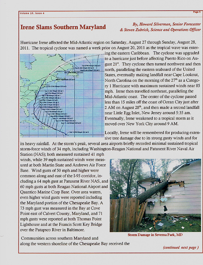
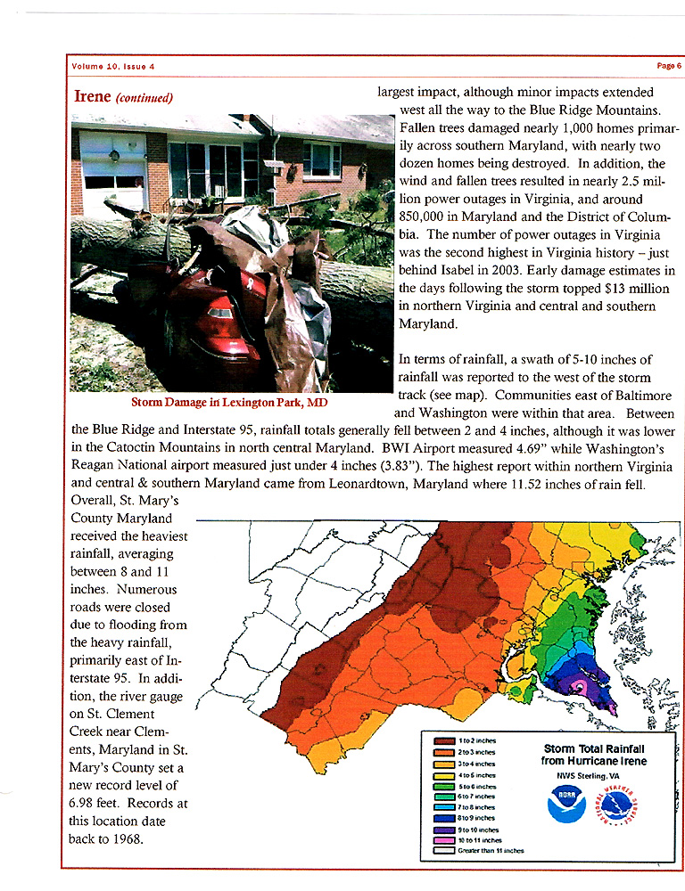
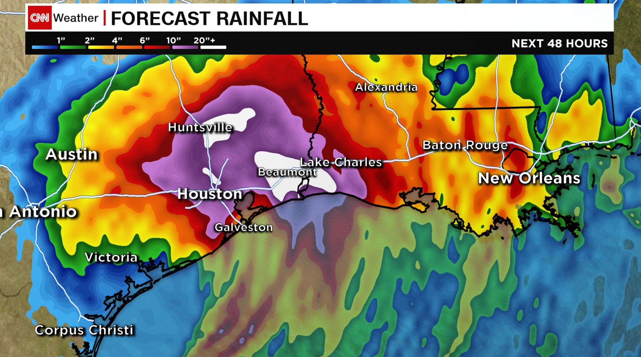
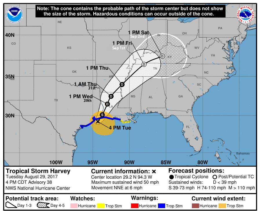
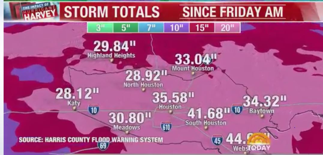
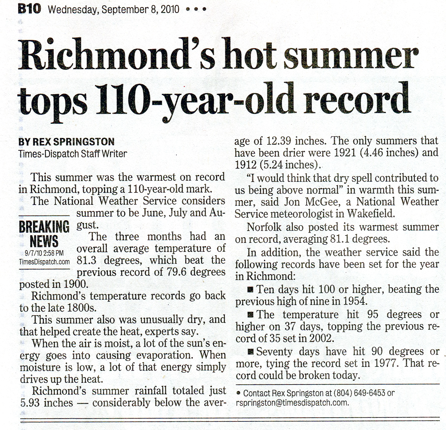