|
JANUARY Happy New Year  1ST 1864 Snow, gales and severe cold hit the Midwest. It was the most bitter cold New Year's day of record with afternoon highs of 16 below zero at Chicago, IL and 25 below at Minneapolis, MN. (David Ludlum, p 6) A farmer near Huntertown, IN reported the same high temperature as Chicago, with a low of -21°. In his weather diary he made the remark "rough day". Louisville, KY dropped 67 degrees to -20°. Lansing, MI set a record low with -23°. (Ref. Wilson Wx. History) 1881 Lowest minimum temperature ever recorded in January for Washington, DC -14°F. The temperature reading was made at the weather bureau office at 24th and M Street, NW. The Naval Observatory in Washington, DC recorded -16.5 degrees Fahrenheit on this date. This same air mass gave the lowest temperature ever recorded in December on December 31, 1880 when a low of 13 below zero F was recorded. Thus, one air mass set the all-time record low temperature for the two months of January and December. (Ref. Washington Weather Records - KDCA) 1885 The temperature plunged to -63° at Poplar River, MT. The residents of Regina, Saskatchewan Canada also rang in the New Year with a record cold temperature of -58°. Locations across the U.S. that reported record lows for the date included: Bismarck, ND: -36°, Fargo, ND: -35°, Huron, SD: -33°, Duluth, MN: -26°, North Platte, NE: -20 °F. (Ref. Wilson - Additional Temperatures Listed On This Link) 1886 Norway's coldest night on record occurred as the low temperature dropped to -60.5° at Karasjok. (Ref. Wilson Wx. History) 1916 Rainmaker Charles Hatfield offered to bring rain to a parched San Diego, California for $10,000. He began to burn strange chemicals on this date to summon rain. It did begin to rain on January 10th. The problem was that it didn't stop raining for days and damaging floods resulted. The city refused to pay him the money. (Ref. AccWeather Weather History) 1918 The coldest period of the winter of 1917 and 1918 occurred from December 29th to January 4th. New England suffered through its coldest New Years Day in modern history. The temperature plunged to -32° at Van Buren, ME., -24° at Northfield, VT, -20° at Bethlehem, NH and -7° at New Haven, CT. Locations reporting daily record lows included: Hartford, CT: -8°, Boston, MA: -3°, Lexington, KY: 3°, Lynchburg, VA: 3°, Richmond, VA: 6°, Roanoke, VA: 8°, Wilmington, NC: 11°, Charlotte, NC: 11°-Tied, Raleigh, NC: 12°, Norfolk, VA: 12°, Jacksonville, FL: 21°, Pensacola, FL: 25°-Tied, West Palm Beach, FL: 35°, Miami, FL: 36° and Key West, FL: 51°. (Ref. Wilson - Additional Temperatures Listed On This Link) 1934 Heavy rain, which began on December 30th, led to flooding in the Los Angeles basin area of California. Flooding claimed the lives of at least 45 persons. Walls of water and debris up to ten feet high were noted in some canyon areas. Rainfall totals ranged up to 16.29 inches at Azusa, with 8.26 inches reported in Downtown Los Angeles. (The Weather Channel) 1935 The Associated Press Wire Photo Service made its debut, delivering the famous weather maps, twice each day to newspapers across the country. (Ref. AccWeather Weather History) 1948 An ice storm glazed surfaces in Chicago, IL, with ˝-1” ice; it was followed by 4”+ snow. Winds to 50 mph common (approx. 100 mph estimate at Glenview Naval Air Station) 11 radio station towers destroyed/damaged. 6,000 Western Union poles down; 5,500 miles of wire broken/tangled. (Ref. Weather Guide Calendar with Phenomenal Weather Events 2011 Accord Pub. 2010, USA) 1949 A six-day blizzard began over the Northern Rockies and the Great Plains. The storm produced the most adverse weather conditions in the history of the west. (David Ludlum) 1965 The New Year began with a 5-day snowstorm that dumped a total of 71.7 inches at Cartwright, Newfoundland Canada. (Ref. Wilson Wx. History) 1966 The maximum temperature for the date is 68°F. at National Airport. (Ref. Washington Weather Records - KDCA) 1970 The biggest mid-winter snowfall accumulation in two decades paralyzed traffic across portions of the north Black Hills of South Dakota. Three to four feet of new snow accumulated over the New Year's Holiday. For the three day period ending this date, a few accumulations included 46 inches at Deadwood and 37 inches at Lead. Gusty winds of 25 to 40 mph produced additional problems by creating widespread drifting which blocked roads. Further west, Lewiston, ID set a record low with -6°. (Ref. Wilson Wx. History) 1971 Eighteen inches of snow at Big Meadows & Winchester, 17.3 Dale Enterprise and National Airport 4.4 inches after midnight. Major snowstorms swept to the Washington area and during the final hours of 1970 and continued into the first hours in 1971. Very heavy snowfall totals were reported across the Washington area, with 8-16 inches of snow common in the immediate metro area. The snowfall in the metro area began during the afternoon of December 31st, 1970. Snow continued to fall through out the evening and ended the morning on January the 1st. At National Airport, 4.9 inches fell during the waning hours of 1970 and then an additional 4.4 inches accumulated after midnight. The snow was driven by strong and northeast winds, which reached 30 to 40 mph at times. Rockville, Maryland and Reston, Virginia reported 14 inches, and Dulles Airport tallied 15.3 inches. For Dulles, the storm set the airport's snowfall record going back to 1963. The record stood until the President's Day snowstorm of February 1979. (p. 80-81 Washington Weather Book 2002 by Ambrose, Henry, Weiss) 1979 The temperature at Maybell, CO plunged to 60 degrees below zero to tie the state record set back in 1951 at Taylor Park. (Ref. The Weather Channel) The current record low for CO is -61 °F set Feb. 1, 1985 also in Mabell. (Extreme Weather p. 54, by Christopher C. Burt) 1984 A severe cold spell finally broke on New Year's Day at Topeka, KS when the mercury finally rose above 32° after 554 hours. An unprecedented cold spell set temperature records every morning from 12/18 to 12/25/1983. A deep snow cover kept temperatures at or below zero for a record-setting 95 consecutive hours from 12/21 – 12/25/1983. The lowest temperature of -17° occurred on 12/22/1983. (Ref. Wilson Wx. History) 1985 A severe ice storm struck southern Lower Michigan as a layer of ice up to one inch thick downed tree limbs and power lines. There were three deaths and eight injuries directly related to the ice storm. Over 430,000 electrical customers were without power, some for as long as 10 days. Total damage was estimated at nearly $50 million dollars. (Ref. Wilson Wx. History) 1987 A winter storm brought rain and snow and high winds to the Southern and Middle Atlantic Coast Region. The storm, which occurred in a period of unusually high astronomical tides, produced a tide of 9.4 feet at Myrtle Beach SC (their highest since Hurricane Hazel in 1954) which caused a total of 25 million dollars damage in South Carolina. (National Weather Summary) (Storm Data) 1988 Arctic cold gripped the north central U.S. The morning low of 31 degrees below zero at Alamosa CO was a record for the date. Squalls in the Great Lakes Region produced 17 inches of snow at Elmira, NY. (National Weather Summary) (Storm Data) 1989 Those who woke up New Year's morning unable to see much farther than the end of their nose had a good excuse, at least in the central U.S., as dense fog prevailed from Texas to Wisconsin. (National Weather Summary) 1990 The New Year and decade began on a rather peaceful note. Snow was primarily confined to the Great Lakes Region, the Upper Ohio Valley, and the Sierra Nevada Range of California. Subzero temperature readings were confined to Minnesota and North Dakota. (National Weather Summary) 1994 Strong winds along the eastern slopes of the Central Rockies gusted to 70 mph at Arlington WY, and gusted to 80 mph near Estes Park CO. Heavy snow in the northeast mountains of Oregon produced 14 inches at Tollgate. A series of storms the first three days of the year produced 20 inches of snow at Lowman, in the west central mountains of Idaho. (National Weather Summary) (Storm Data) 2002 Intense lake effect snow squalls buried sections of Lewis County in New York with tremendous snows. Snowfalls for the four day period ending on this day were 127 inches at Montague, 104 inches at Highmarket and 86 inches at North Osceola. The 127 inches at Montague is one of the greatest snowfalls ever recorded for a single lake effect snow event. (Ref. Wilson Wx. History) 2004 Sierra Mountains, California: Heavy snow derails a passenger car on the California Zephyr 40 miles west of Truckee. The westbound Amtrak train is detained for 14 hours by the weather and accident, stranding 300 people. (Ref. Wx.Doctor) 2006 Sydney, Australia records a high of 111.6°, the second hottest day on record here, their highest maximum temperature on record here is 113.5° recorded in 1939. Records date back to 1859. Meanwhile, Sydney Airport recorded its hottest day on record reaching 113.4°. (Ref. Wilson Wx. History) 2009 A strong blizzard which began on New Years Eve continues to hit the Canadian Maritimes. The storm was characterized by very low barometer readings including: Sable Island, Nova Scotia: 966 millibars or 28.54 inches of mercury and Sidney, Nova Scotia, 970 millibars or 28.65 inches of mercury with strong winds. One gust in Halifax Harbor reached 85 mph. Charlottetown, Prince Edward Island was buried under 19.3 inches of snow while Yarmouth Airport, Nova Scotia received 16 inches of snow and Cheticamp, Nova Scotia, recorded 14 inches. (Ref. Wilson Wx. History) 2014 TOP 10 U.S. Weather Events 2014 Midwest to Northeast Snowstorm and Extreme Cold: January 1-3. This long-track storm dropped snow from Montana to Maine, canceling thousands of flights from Chicago, Illinois, to Boston, Massachusetts. Up to 18 inches fell in the Chicago area, and temperatures dipped to -43°F at International Falls, Minnesota. Ref. (Weatherwise MAY- JUNE 2015, page 14) |
|
JANUARY 2ND 1777 George Washington retreated across the frozen mud to escape the British at Trenton and reach safe shelter in northern New Jersey. (Ref. AccWeather Weather History) 1876 The maximum temperature for the date is 71°F. in Washington, DC. (Ref. Washington Weather Records - KDCA) 1885 Duluth, MN recorded its coldest temperature ever, with a reading of -41°. The current record for MN is at Tower, MN on 2-2-1996 at -60 °F. (Ref. AccWeather Weather History) 1893 Thirteen inches of snow fell at Little Rock, AR to establish the city's record for greatest 24 hour snowfall. (Ref. AccWeather Weather History) 1897 Traveling “like an army of demons” an F3 tornado destroyed a number of homes in Mooringsport, LA; 5 deaths., 21 hurt. Some people believe a tornado myth which claims a hill will disrupt tornadoes. This tornado destroyed 3 large homes on a hill SW of town. (Ref. Weather Guide Calendar with Phenomenal Weather Events 2011 Accord Pub. 2010, USA) 1899 The minimum temperature for the date at Washington, DC is -1°F and at Dale Enterprise -11°, just West of Harrisonburg, VA (Ref. Washington Weather Records - KDCA and Dale Enterprise Weather Records) 1904 Nineteen inches of snow fell at the Blue Hill Observatory in Milton, MA as a major snowstorm struck New England. (Ref. AccWeather Weather History) 1910 A great flood in Utah and Nevada washed out 100 miles of railroad between Salt Lake City UT and Los Angeles CA causing seven million dollars damage. (David Ludlum) 1918 The coldest period of the winter of 1917 and 1918 occurred from December 29th to January 4th. The temperatures for this date were a high of 13 degrees Fahrenheit and a low of +10 degrees Fahrenheit. 1941 Grand Portage, MN gets over 4.5 inches of precipitation in 24 hours. That's roughly how much normally falls there during the winter months (Nov.-Feb). (Ref. AccWeather Weather History) 1948 An ice storm glazed surfaces in Chicago, IL, with ˝-1” ice; it was followed by 4”+ snow. Winds to 50 mph common (approx. 100 mph estimate at Glenview Naval Air Station) 11 radio station towers destroyed/damaged. 6,000 Western Union poles down; 5,500 miles of wire broken/tangled. (Ref. Weather Guide Calendar with Phenomenal Weather Events 2010 Accord Publishing, USA) 1949 For 7 weeks, blizzard after blizzard pounded the Great Plains. Temperatures plunged to -50° in some areas. Over 200 people perished. Livestock was hard hit, with over 150,000 head of sheep killed. On this date, the worst blizzard in many years struck northern Colorado. The storm produced blizzard conditions with wind gusts up to 50 mph all day on the 3rd when temperatures stayed in the single digits. That resulted in dangerous wind chill readings from -40° to -55°. The former Stapleton Airport in Denver received 13.3 inches while downtown Denver received 11.8 inches. Snow fell for 51 straight hours in downtown Denver. (Ref. Wilson Wx. History) (Ref. AccWeather Weather History) 1955 Hurricane Alice had actually formed on December 30, 1954. Hurricane Alice is the only known Atlantic hurricane to span two calendar years and one of only two named Atlantic tropical cyclones, along with Tropical Storm Zeta of 2005, to do so. It was officially recognized as a significant tropical cyclone on January 2, 1955. At the time, the National Weather Service used the same naming list each year, so the name given to this storm was "Alice" and it was designated as a part of the 1955 Atlantic hurricane season. However, it was found during post-storm analysis that the storm had actually formed on December 30, and was instead a part of the 1954 season. Therefore, the season had two storms named "Alice" — the first storm of the season, and the last. Had Alice been discovered before the end of the calendar year, it would have been named Irene, the next name on the 1954 list. Some reports named this storm Alice2 to avoid confusion with the earlier Alice from June 1954. (Ref. AccWeather Weather History) 1961 The coldest temperature of record for the state of Hawaii was established with a reading of 14 degrees atop Haleakela Summit. This record would be broken on 5/17/1979 when the summit atop Mauna Kea dropped to 12°. (David Ludlum) (Ref. Wilson Wx. History) 1987 A winter storm moving up the Atlantic coast brought heavy snow and high winds to the northeastern U.S. Wind gusts reached 82 mph at Trenton NJ and Southwest Harbor in Maine. Snowfall totals ranged up to two feet at Salem NH and Waterboro, ME. (National Weather Summary) (Storm Data) 1988 "Old Man Winter" took a siesta, with snow a scarcity across the nation. For the second day in a row Alamosa CO reported a record low of 31 degrees below zero. (National Weather Summary) 1989 Strong and gusty winds prevailed along the eastern slopes of the northern and central Rockies. Winds gusted to 71 mph at Colorado Springs CO and Livingston MT. (National Weather Summary) (Storm Data) 1990 The first winter storm of the New Year and decade developed in the southwestern U.S., and blanketed the northern mountains of Utah with 12 to 23 inches of snow. Up to 22 inches of snow was reported in the Alta-Snowbird area. The storm brought Las Vegas NV their first measurable precipitation in four and a half months, since the 17th of August. (National Weather Summary) (Storm Data) 1992 Record blizzard hits Middle East, Jerusalem 16 inches, Amman Jordan 26 inches ---- heaviest snow in over 40 years (Bob Ryan'' 2000 Almanac) 1994 High winds buffeted the Northern Front Range of Colorado during the morning hours. Peak wind gusts included 105 mph atop Squaw Mountain near Idaho Springs and 89 mph at Fort Collins. A fast moving "Alberta Clipper" brought up to six inches of snow to Iowa. Up to a foot of snow blanketed the Snowy Range Mountains in southeastern Wyoming. (National Weather Summary) (Storm Data) 1999 Chicago had its greatest calendar day snowfall with a total of 18.6 inches of snow on this date. Greatest one day snow - Snow Trivia for Chicago - NWS Grand Rapids, MI recorded 22 inches for their greatest snowstorm ever. Detroit, MI reported a foot of snow and Milwaukee, WI was buried under 15.4 inches; the city's biggest snowstorm in 52 years. Heavy snow of 6 to 8 inches fell across part of northeast South Dakota from the late afternoon hours of the 1st to the early morning hours on this date. Strong north winds of 15 to 30 mph combined with temperatures in the single digits generated wind chills from -25° to -40° and visibilities below 1/4 of a mile at times. Thousands of holiday travelers were stranded on planes at Detroit’s Metro Airport. Many were stuck on planes for hours when snow plows were unable to clear paths to the gates. (Ref. Wilson Wx. History) (Ref. AccWeather Weather History) 2006 Montgomery, Christian and Shelby Counties, Illinois: A microburst from a severe thunderstorm likely killed more than 35 snow geese found in farm fields southeast of Springfield. The medical examiner reports lesions observed in the dead birds are consistent with injury to birds falling from the sky — causing ruptured internal organs and internal bleeding. (Ref. Wx.Doctor) 2007 The treacherous Rogers Pass, British Columbia Canada received more than 28 inches of snow fall in less than 24 hours. Several hundred motorists are stranded on the Trans-Canada Highway west of Banff, Alberta after heavy snowfall sets off avalanches rumbling through the mountain pass. (Ref. Wilson Wx. History) 2010 A blizzard dumped 32.9 inches of snow on Burlington, VT, the city's all-time biggest snowstorm in 120 years of record keeping. (Ref. Wilson Wx. History) Florida endured its 10th coldest January of record. Gainesville started its record of 13 days consecutively of freezing temperatures (the old record was nine) set December of 1960. Tallahassee had 14 consecutive days; the old record was set January 27 to February 8 of 1966. (Ref. Weather Guide Calendar with Phenomenal Weather Events 2012 Accord Pub. 2011, USA) 2013 Heavy snowfall over the Chicago area of more than 10 inches in many arears. (Ref. Tom Skilling's Weather Center WGN9) 2014 TOP 10 U.S. Weather Events 2014 Midwest to Northeast Snowstorm and Extreme Cold: January 1-3. This long-track storm dropped snow from Montana to Maine, canceling thousands of flights from Chicago, Illinois, to Boston, Massachusetts. Up to 18 inches fell in the Chicago area, and temperatures dipped to -43°F at International Falls, Minnesota. Ref. (Weatherwise MAY- JUNE 2015, page 14) |
|
JANUARY 3RD 1777 An overnight freeze enabled George Washington and his troops to flank the British at Trenton, cross their lines at Princeton, and seek security in the hills of northern New Jersey. (David Ludlum p. 6) 1877 The minimum temperature for the date is -3°F. in Washington, DC. (Ref. Washington Weather Records - KDCA) 1883 Residents of the Midwest and Ohio Valley observed a brilliant meteorite. Witnesses said that the trail left by the meteorite was visible for as long as 30 minutes. (Ref. Wilson Wx. History) 1911 Brutal record cold prevailed from the Plains to the West Coast. Locations reporting record lows for the date included: International Falls, MN: -35°, St. Cloud, MN: -31°, Grand Forks, ND: -31°, Aberdeen, SD: -30°, Duluth, MN: -30°, Huron, SD: -29°, Rochester, MN: -28°, Norfolk, NE: -27°, Valentine, NE: -24°, Sioux Falls, SD: -23°-Tied, North Platte, NE: -22°, Scottsbluff, NE: -22°, Sioux City, IA: -20°, La Crosse, WI: -20°-Tied °F. (Ref. Wilson - Additional Temperatures Listed On This Link) 1918 The coldest period of the winter of 1917 and 18 occurred from December 29th to January 4th. The temperatures for this date were a high of 15 degrees Fahrenheit and a low of +4 degrees Fahrenheit at KDCA. Extreme cold recorded in Western Maryland -30° at Oakland, -18° Hagerstown and -1°F in Frederick. Also a light snow falls in Frederick. (Bob Ryan's 2000 Almanac) (Ref. Wilson - Additional Temperatures Listed On This Link) 1921 The first radio broadcasts of weather forecasts began as the University of Wisconsin began using the new medium. Within two years, over 140 radio telephone stations would be broadcasting weather reports by radio. (Ref. AccWeather Weather History) 1949 The Great Blizzard of 1949 continued and grew in intensity with heavy snow, strong winds and bitter cold temperatures. On this day Cheyenne, WY recorded their highest daily precipitation total ever in January with 1.32 inches. Many areas recorded all-time daily record snowfalls including 26.7 inches at Chadron, NE with snowfall estimated at 25 to 30 inches burying Cheyenne and much of southeast Wyoming. This combined with temperatures at or below zero all day and wind gusts over 50 mph paralyzed the region. (Ref. Wilson Wx. History) An F4 tornado killed 57 and injured 435 at Warren, AR. Damage was $1.3 million. An alert school bus driver stopped to allow an F3 tornado to pass in front of his bus south of Haynesville, LA. (Ref. AccWeather Weather History) 1961 A three day-long ice storm was in progress over northern Idaho, which produced an accumulation of ice eight inches thick, a U.S. record. Heavy fog, which blanketed much of northern Idaho from Grangeville to the Canadian border, deposited the ice on power and phone lines causing widespread power outages. (David Ludlum) (The Weather Channel) 1970 The barometer at Barrow, AK soared to a reading of 31.43 inches of mercury. (Ref. AccWeather Weather History) 1971 The temperature reached a scorching 96° at Cotulla, TX, just two degrees shy of the U.S. record for January. Other locations in Texas that reported record highs for the date included: Corpus Christi: 88°, San Antonio: 86°, Austin (Bergstrom): 84° and Austin (Camp Mabry): 83°. (Ref. AccWeather Weather History) (Ref. Wilson Wx. History) 1977 14.2 inches of snow falls on Mankato, MN. (Ref. AccWeather Weather History) 1981 Embarass, Wannaska, and Tower all hit 38 below zero. (Ref. AccWeather Weather History) 1987 A powerful Pacific coast storm blasted the western U.S. with high winds, heavy rain and heavy snow. Winds gusted to 96 mph at Cape Blanco OR, and snowfall totals reached 20 inches in the Sierra Nevada Range of California. (National Weather Summary) (Storm Data) 1988 After a day of rest, "Old Man Winter" came back as a triple threat, hitting both coasts with winter storms, and blasting the central U.S. with cold arctic air. Snow and ice in the eastern U.S. caused 4.5 million dollars damage to homes and vehicles in North Carolina. The storm in the western U.S. produced two feet of snow in the Lake Tahoe area of Nevada, and temperatures in North Dakota plunged to 30 degrees below zero, with wind chill readings as cold as 95 degrees below zero. (National Weather Summary) (Storm Data) (Ref. AccWeather Weather History) 1989 Thirteen cities in the southeastern U.S., and five more in Washington and Oregon, reported new record high temperatures for the date. Highs of 78 degrees at Galveston TX and 82 degrees at Lake Charles LA were records for the month of January. (National Weather Summary) 1990 A winter storm in the southwestern U.S. spread snow across Colorado and New Mexico. Heavy snow fell in southwestern Colorado, with 13 inches reported at Wolf Creek Pass. Snow spread into the Central Plains Region during the day, with six inches reported at Garden City KS. (National Weather Summary) 1993 The barometer at Canton, NY plummeted to 28.20 inches of mercury, the lowest ever recorded at a non-coastal station in the U.S. An intense area of low pressure moving along the Appalachian Mountains caused record low barometer readings across the East. (Ref. Wilson Wx. History) 1994 A heavy wet snow blanketed much of the state of Ohio, with 12 to 18 inches reported in counties along the Ohio River. Newport received 21 inches. Thunder and lightning accompanied the snow, with five inches reported in Washington County and Noble County between 7 AM and 8 AM Tuesday. Parts of Washington County were without electricity for eight days following the storm. (National Weather Summary) (Storm Data) 1996 The first in the series of snowstorms to strike the eastern U.S. over the next ten days was in progress over New England, New York, and Pennsylvania. Rochester, NY was buried under 23 inches of snow in 24 hours for the city's greatest 24 hour snowfall on record. 21 inches was recorded at Oswego, NY and 18 inches fell at Batavia, NY. Other snowfall totals included 16 inches at Milton, MA, 14 inches at Montpelier, VT, 13.3 inches at Montrose, PA and 13.1 inches at Boston, MA. (Ref. AccWeather Weather History) 1997 The greatest flood on record occurred at Yosemite Valley, CA. The Merced River crested at Pohono Bridge at 23.45 feet, an 80 year high. Extensive damage occurred to park trails, roads, sewer and water systems and housing totaling $178 million dollars in damage there alone. (Ref. AccWeather Weather History) 1999 A powerful area of low pressure and deep Arctic high pressure brought almost all winter elements to central and northeast South Dakota as well as west central Minnesota from the afternoon on this date to the morning of the 5th. Late during the evening on this date, the freezing rain changed to sleet and then snow, with substantial snowfall accumulations of 6 to as much as 27 inches by late on the 4th. As the deep Arctic high pressure pushed in through the morning and afternoon of the 4th, northwest winds increased to 25 to 45 mph gusting to 55 mph creating widespread blizzard conditions, drifts up to 20 feet, and wind chills from -40 °F to -70 °F. The heavy accumulation of ice and snow across parts of central and mainly across northeast South Dakota resulted in the ROOF COLLAPSE OF OVER 150, MAINLY RURAL, BUILDINGS. The collapse of so many buildings from snow and ice was believed to be the first in this area. On most other buildings, the snow had to be shoveled or blown off. One man was killed in west central Minnesota as he was trying to shovel snow off the roof of a building. A few homes during the storm were buried by the huge snow drifts near Lake Poinsett. Some people were without power for several days in the extreme cold conditions. At Aberdeen, SD heavy snow blocking a furnace exhaust vent, sent 3 family members to the hospital for carbon monoxide poisoning. Also, the snowmobile club, the drift busters were called upon for the first time in several years to deliver medicine, take patients to the hospital, and carry essential workers to work and home. Interstates 29 and 90 were both closed for a few days along with most state highways. Area airports were closed or flights were canceled or delayed. The heavy snowfall from this storm brought the widespread snowpack up to 2 to 5 feet. For the winter season so far, the area had record snowfall and record cold. Snowfall amounts of 1 to over 2 feet included, 27 inches at Wheaton, SD, 24 inches at Sisseton, SD, 22 inches at Britton, SD, 20 inches at Webster, SD, 18 inches at Faulkton, SD. (Ref. Wilson Wx. History) 2000 The maximum temperature for the date in Washington, DC is 68 °F. (Ref. Washington Weather Records - KDCA) 2002 You know the weather is bad when The Weather Channel closes their offices for the day. Parts of the Deep South ground to a standstill as a rare 2 day winter storm brought snow to the area, including Atlanta, where only essential personnel reported for work at the network. (Ref. AccWeather Weather History) 2014 TOP 10 U.S. Weather Events 2014 Midwest to Northeast Snowstorm and Extreme Cold: January 1-3. This long-track storm dropped snow from Montana to Maine, canceling thousands of flights from Chicago, Illinois, to Boston, Massachusetts. Up to 18 inches fell in the Chicago area, and temperatures dipped to -43°F at International Falls, Minnesota. Ref. (Weatherwise MAY- JUNE 2015, page 14) 2018 This was a light but cold snow for Glen Allen starting at 11:30 PM on the 3rd and lasting a little less than 10 hours until 08:15 AM of the 4th. This was a big snow for the east coast with 10 to 12 inches and also very high winds that caused coastal flooding in New England. Glen Allen was near the western edge of the storm and the storm lasted about 9 hours and 45 minutes giving 1.9 inches and the snowfall rate was very slow about 0.2 inches per hour. It was a very cold snow and from the time the precipitation showed up on radar over Glen Allen it took about 4 to 5 hours before the snow made it to the ground because of sublimation. At 1800 the dew point was only 8.3°F. Whiteout conditions temporarily suspended flights at JFK airport, where the wind gusted as high as 55 mph. It was blizzard conditions along the coast with many coastal areas getting 60 mph winds. Central Park reported 7.8 inches of snow at 1 p.m. January 3, it snowed in Tallahassee, Fla. for the first time in nearly three decades on Wednesday morning, the city said, while residents marveled at their frozen pools and snow-dusted lawns. Charleston, SC had 5 inches of snow for the City's third snowiest day. The 12-inch tripping bucket gave a total of 0.21 inches but the heater in the gauge evaporates some of the liquid. The eight-inch gauge gave 0.24 inches and the core sample gave 0.25 inches. With the surface temperature as low as it was it was hard to rationalize a liquid to snow radio of less than 10 to 1. But after all the observations 0.03 inches will be added to the total. One other observation made last night at 2300 was the broken and irregular particles had moderate amount of riming. Thus the snow to liquid equivalent ratio was 8 to 1 ! (Ref. NWS forecast map for snowfall on January 2nd) (Ref. NWS forecast map for snowfall on January 3rd) (Ref. LLK Snowfall Observations (Ref. NWS Map of Snowfall Totals (Ref. NWS SE Snowstorm |
|
JANUARY 4TH 1641 The Mount Parker volcano on the Philippine island of Mindanao erupted. Dust from the eruption circled the globe, blocked sunlight and dropped global temperatures through 1643. (Ref. AccWeather Weather History) 1780 A major snowstorm buried George Washington and his troops at their headquarters in Morristown, NJ. (Ref. AccWeather Weather History) 1859 A powerful winter storm across New England buried Hartford, CT under 36 inches of snow and 26 inches at Middletown, CT. 30 inches fell in 12 hours at Goffstown, NH. (Ref. AccWeather Weather History) 1877 The minimum temperature for the date is -3°F. in Washington, DC again today after -3°F yesterday. (Ref. Washington Weather Records - KDCA) 1888 Sacramento CA received 3.5 inches of snow, an all-time record for that location. The heaviest snow in recent history was two inches on February 5th in 1976. (4th-5th) (The Weather Channel) 1917 A tornado with F3 damage cut a 15-mile path and struck a school at Vireton in Pittsburg County, Oklahoma, killing 16 people. It ranks as the 4th worst school tornado disaster in U.S. history. (Ref. AccWeather Weather History) The deadliest U.S. tornado struck the Choctaw Indian Baptist School at Vireton, OK; 16 students killed (some carried 100 yards) and 10 injured. The building disintegrated as the teacher (whose jaw was broken) tried to keep the school’s door shut. (Ref. Weather Guide Calendar with Phenomenal Weather Events 2011 Accord Pub. 2010, USA) 1918 The coldest period of the winter of 1917 and 1918 occurred from December 29th to January 4th. The temperatures for this date were a high of 20 degrees Fahrenheit and a low of +4 degrees Fahrenheit. (Ref. Washington Weather Records - KDCA) 1946 A series of tornadoes struck northeast Texas, killing 30 people. The deadliest tornadoes struck near Palestine and Nacogdoches. (Ref. AccWeather Weather History) 1949 A blizzard continued its onslaught across parts of the Rockies and northern Plains but finally began to wane late in the day. By the time it was over, 41 inches of snow had buried Chadron, NE while 30 to 40 inches of snow fell over in and around Cheyenne, WY. Cheyenne was hit hard by 60 hours of snow and near-hurricane force winds. Between 20 and 30 inches was recorded at Laramie, WY. 17 lives were lost in the storm while many were marooned for days due to impassable roads and huge drifts. (Ref. AccWeather Weather History) (Ref. Wilson Wx. History) 1971 A blizzard raged from Kansas to Wisconsin, claiming 27 lives in Iowa. Winds reached 50 mph, and the storm produced up to 20 inches of snow. Winona, MN gets over 14 inches of snow. (David Ludlum p. 6) (Ref. AccWeather Weather History) (Ref. Wilson Wx. Additional Information) 1980 On January 4 and 5, 1980 a heavy wet snow fell over eastern Virginia with as much as 18 inches reported at Williamsburg. Richmond had 1.6 inches of snow on the 4th and 13.3 inches on the 5th for a total of 14.9 inches which was the third largest January snow for Richmond. (Ref. Virginia Weather History) 1981 A strong upper level trough across the Great Lakes and East Coast combined with arctic high pressure across the northern Plains brought record cold. Toronto, Ontario Canada fell to their all-time record low of -24.3° and Lansing, MI set a new January record low with -29°. Locations that reported daily record low temperatures for the date included: Tower, MN: -45 °F, Old Forge, NY: -42°, East Haven, VT: -42°, Houlton, ME: -41°, Enosburg Falls, VT: -41°, International Falls, MN: -39 °F. (Ref. Wilson Wx. History) 1982 Milwaukee WI was shut down completely as a storm buried the city under 16 inches of snow in 24 hours. It was the worst storm in thirty-five years. (David Ludlum) A major Pacific storm dumped 6 to 8 feet of snow at Squaw Valley, CA in just 26 hours. Up to 25 inches of rain fell in the San Francisco Bay area, causing severe mudslides. Echo Summit set the state's 24-hour snowfall record with 67 inches. 6 to 8 feet of snow fell in 26 hours at Squaw Valley, CA. (Ref. Wilson Wx. History) 1987 A storm moving off the Pacific Ocean spread wintry weather across the southwestern U.S., with heavy snow extending from southern California to western Wyoming. Up to 15 inches of snow blanketed the mountains of southern California, and rainfall totals in California ranged up to 2.20 inches in the Chino area. (National Weather Summary) (Storm Data) (Ref. Wilson Wx. Additional Information) 1988 Frigid arctic air invading the central and eastern U.S. left Florida about the only safe refuge from the cold and snow. A storm in the western U.S. soaked Bodega Bay in central California with 3.12 inches of rain. (National Weather Summary) 1989 Up to a foot of snow blanketed the mountains of West Virginia, and strong winds in the northeastern U.S. produced wind chill readings as cold as 60 degrees below zero in Maine. Mount Washington, NH reported wind gusts to 136 mph along with a temperature of 30 below zero! (National Weather Summary) 1990 A winter storm moving out of the southwestern U.S. spread heavy snow across Nebraska and Iowa into Wisconsin. Snowfall totals in Nebraska ranged up to 7 inches at Auburn and Tecumseh. Totals in Iowa ranged up to 11 inches at Carlisle. In Iowa, most of the snow fell between midnight and 4 AM. (National Weather Summary) (Storm Data) 1992 A low pressure area with sub-tropical characteristics developed explosively over the Gulf Stream waters east of Cape Hatteras, NC and apparently deepened 18 millibars in just 3 hours. The central pressure dropped from 994 (29.35 inches of mercury) to 976 millibars (28.82 inches of mercury) and bottomed out at 968 millibars (28.68 inches of mercury) 3 hours later. An offshore buoy recorded a pressure drop of 9.2 millibars in just one hour. Major coastal flooding and beach erosion occurred along the New Jersey, Maryland, Delaware, and Virginia coasts as the storm made landfall. A wind gust to 89 mph occurred at Chincoteague, VA and 83 mph was recorded at Indian River, DE. Ocean city, MD was hit very hard with winds sustained at 50 mph and gusts to 70 mph. At the Ocean City airport, the runways were flooded at their worst ever. Substantial beach erosion was reported at Rehoboth Beach, DE which rivaled damage one by the great March 1962 storm. Total damage reached $45 million in New Jersey alone. Rainfall at inland locations over the Mid-Atlantic was very heavy in some places with Witts Orchard, VA checking in with a 24 hour total of 7.56 inches. (Ref. Wilson Wx. History) 1994 A major winter storm blanketed much of the northeastern U.S. with heavy snow. More than two feet was reported in northwestern Pennsylvania, with 33 inches at Waynesburg. There were ten heart attacks, and 185 injuries, related to the heavy snow in northwest Pennsylvania. Whiteout conditions were reported in Vermont and northeastern New York State. A wind gusts to 75 mph was clocked at Shaftsbury, VT. In the Adirondacks of eastern New York State, the town of Tupper reported five inches of snow between 1 PM and 2 PM. (National Weather Summary) (Storm Data) Six inches of snow fell in one hour at Elkins, WV. (Ref. Wilson Wx. Additional Information) (Ref. AccWeather Weather History) 1997 Barcroft Hills Annandale VA maximum 71° a new record maximum for January old record was 70° Over one hundred and eighty record highs were tied or broken between the 2nd and 4th. The maximum temperature for the date in Washington, DC is 73°F (Ref. Washington Weather Records - KDCA) (Ref. Wilson Wx. Many Additional Temperatures) 2003 Des Moines, Iowa: A record dry spell –53-days long – ends in Des Moines. (Ref. Wx. Doctor) - Heavy snows fell over the Northeast just one week after a Christmas Day storm brought heavy snowfall amounts to parts of the same region. Some areas picked up an additional one to two feet of snow. 17.4 inches fell in Burlington, VT making it the second snowiest day since records have been kept there. (Ref. Wilson Wx. Additional Information) 2008 One of the most powerful Pacific storms in years brought high winds, locally heavy rains and significant high elevation snow to interior Central California through the 5th. The heaviest rain fell in the foothills and in the southern Sierra Nevada up through about 7,000 feet in elevation where rainfall amounts reached as much as 9.41 inches at Wawona. In the High Sierra above 8,000 feet, the storm produced significant snowfall amounts in the Sierra with Aspendell reporting a total of 3 feet in 48 hours. Strong winds of 50 to 70 mph also destroyed the roof of a school and flipped over two glider planes in Avenal. Other wind gusts clocked included 75 mph at Crane Flat, 67 mph at Inyokern and 66 mph at Kettleman Hills. Bishop, CA reported 4 inches of rain, setting their all-time greatest one day rain total. (Ref. Wilson Wx. History) 2018 This was a light but cold snow for Glen Allen starting at 11:30 PM on the 3rd and lasting a little less than 10 hours until 08:15 AM of the 4th. This was a big snow for the east coast with 10 to 12 inches and also very high winds that caused coastal flooding in New England. Glen Allen was near the western edge of the storm and the storm lasted about 9 hours and 45 minutes giving 1.9 inches and the snowfall rate was very slow about 0.2 inches per hour. It was a very cold snow and from the time the precipitation showed up on radar over Glen Allen it took about 4 to 5 hours before the snow made it to the ground because of sublimation. At 1800 the dew point was only 8.3°F. Whiteout conditions temporarily suspended flights at JFK airport, where the wind gusted as high as 55 mph. It was blizzard conditions along the coast with many coastal areas getting 60 mph winds. Central Park reported 7.8 inches of snow at 1 p.m. January 3, it snowed in Tallahassee, Fla. for the first time in nearly three decades on Wednesday morning, the city said, while residents marveled at their frozen pools and snow-dusted lawns. Charleston, SC had 5 inches of snow for the City's third snowiest day. The 12-inch tripping bucket gave a total of 0.21 inches but the heater in the gauge evaporates some of the liquid. The eight-inch gauge gave 0.24 inches and the core sample gave 0.25 inches. With the surface temperature as low as it was it was hard to rationalize a liquid to snow radio of less than 10 to 1. But after all the observations 0.03 inches will be added to the total. One other observation made last night at 2300 was the broken and irregular particles had moderate amount of riming. Thus the snow to liquid equivalent ratio was 8 to 1 ! (Ref. LLK Snowfall Observations (Ref. NWS forecast map for snowfall on January 2nd) (Ref. NWS forecast map for snowfall on January 3rd) (Ref. NWS Jan.4th Extreme Pressure drop in the NE - Called a Low Pressure Bomb) (Ref. NWS Map of Snowfall Totals |
|
JANUARY 5TH 1835 It was a record cold morning in the eastern U.S. The mercury at the Yale Campus in New Haven CT plunged to 23 degrees below zero, and reached 40 below in the Berkshire Hills of Connecticut. (David Ludlum) Jan. 5, 1835: Alexandria, VA recorded the temperature at -15°F. The Potomac River was frozen and the Chesapeake Bay froze down to the Virginia Capes for the first time in almost 50 years. (Ref. Virginia Weather History) 1877 The minimum temperature for the date is -3°F. in Washington, DC for the third day in a row. (Ref. Washington Weather Records - KDCA) 1884 Several all-time temperature records were observed as one of the most severe cold waves ever struck the Midwest: Several locations set all-time record lows including: All-time records included Omaha, NE: -32°, Des Moines, IA: -30°, Peoria, IL: -27° and -22° at St. Louis, MO. Locations that reported daily record lows included: Bismarck, ND: -35°, Huron, SD: -35°, La Crosse, WI: -29°, Minneapolis, MN: -28 °F. Many of these records are still on the books. (Ref. Wilson Wx. Many Additional Temperatures) (Ref. AccWeather Weather History) 1892 An F3 tornado killed 3, hurt 20 on its rampage from WSW of Fayetteville, Georgia to near McDonough. It was noted by some that its roar could be heard for miles. (Ref. Weather Guide Calendar with Phenomenal Weather Events 2012 Accord Pub. 2011, USA) 1904 Bitterly cold air gripped the northeastern U.S. Morning lows of -42 degrees at Smethport, PA and -34 at River Vale NJ established state records. (Ref. Wilson Wx. Many Additional Temperatures) (The Weather Channel) 1913 The temperature at the east portal to Strawberry Tunnel reached 50 degrees below zero to tie the record established at Woodruff on February 6, 1899. (David Ludlum) This record was broken on 2/1/1985. Locations that set daily record lows for the date included: Medford, OR: 13°, Yuma, AZ: 25° and San Diego, CA: 36°-Tied. (Ref. Wilson Wx. History) 1962 Twin tornadoes, 100 yards apart, destroyed 10 homes, 10 trailers and damaged 300 homes at Crestview, FL. One person was killed and 65 people were injured. (Ref. Wilson Wx. History) 1974 The warmest temperature ever recorded in Antarctica occurred as Vanda Station on the South Coast reported 59°. (Ref. Wilson Wx. History) 1980 On January 4 and 5, 1980 a heavy wet snow fell over eastern Virginia with as much as 18 inches reported at Williamsburg. Richmond had 1.6 inches of snow on the 4th and 13.3 inches on the 5th for a total of 14.9 inches which was the third largest January snow for Richmond. (Ref. Virginia Weather History) 1982 A three-day rainstorm in the San Francisco area finally came to an end. Marin County and Cruz County were drenched with up to 25 inches of rain, and the Sierra Nevada Range was buried under four to eight feet of snow. The storm claimed at least 36 lives, and caused more than 300 million dollars damage. (Storm Data & David M. Ludlum p. 7) 1987 A massive winter storm spread heavy snow from the southwestern U.S. into the Rockies. In Utah, the Alta ski resort reported a storm total of 42 inches of snow. Winds gusted to 64 mph at Albuquerque NM. (National Weather Summary) (Storm Data) 1988 Thunderstorms helped produce heavy snow in the Lower Great Lakes Region. Snow fell at the rate of four to five inches per hour, and snowfall totals ranged up to 69 inches at Highmarket NY. (National Weather Summary) (Storm Data) 1989 A strong Pacific cold front produced heavy snow and high winds in Nevada. Winds gusted to 80 mph north of Reno, while up to two feet of snow blanketed the Lake Tahoe ski area. (National Weather Summary) (Storm Data) 1990 Thunderstorms produced heavy rain in the Central Gulf Coast Region. New Orleans LA was drenched with 4.05 inches of rain in 24 hours. An overnight storm blanketed the mountains of northern Utah with up to eleven inches of snow. (National Weather Summary) (Storm Data) 1993 Maui, Hawaii: Winds reaching 100 mph down power lines on Maui's Mount Haleakala laden with up to 18 inches of ice that accumulated on the summit. (Ref. AccWeather Weather History) 1998 One of the greatest ice storms in the history of northern New England and Southern Quebec Canada brought coatings 1 to 3 inches thick across the area through the 10th. Through the 10th observations of freezing rain and drizzle in Quebec exceeded 80 hours, nearly double total average annual number of hours of freezing precipitation. The total accumulation of water equivalent of freezing precipitation, mixed at times with light snow and ice pellets, exceeded 4.3 inches at Cornwall, 3.9 inches at Montreal, 3.3 inches at Ottawa and 2.9 inches at Kingston, amounts of ice accumulation nearly twice the accumulation in notable ice storms that hit the Ottawa area in 1986 and Montreal in 1961. The thickness of ice accumulated reached 4.7 inches in places. Across northern New York and Vermont freezing rain accumulation reached 2 to 4 inches thick, and most of central Maine saw about 1 to 2 inches of freezing rain. The area of the storm receiving more 1.6 inches or more of ice held 18% of Canada's population: 56% of Quebec residents and 11% of residents from Ontario. It also accounted for 19% of all Canadian urban lands, 57% in Quebec and 19% in Ontario. At the height of the ice storm, 57 Ontario communities and 200 in Quebec declared a disaster situation. In the United States, President Clinton called the National Guard to duty in the affected areas and declared 16 counties in Maine, 9 in New Hampshire, 6 in New York and 6 in Vermont federal disaster areas. The greatest visible impact to those affected struck the power delivery systems throughout the region. The large electrical transmission towers that brought power to local communities fell as easily as the power poles that delivered the services to the residents. In Quebec alone, an estimated 1,000 transmission towers and 35,000 wooden utility poles fell or were twisted beyond recognition by the heavy ice and following winds. An additional 300 transmission towers were downed in Ontario. Over a million households in Canada lost power, some for over a month. In the U.S., the estimates from New York State, Vermont, New Hampshire and Maine were of the same order, in excess of a million household affected. The storm also downed millions of trees across the region; some of them took transmission lines with them, others blocked road and damaged vehicles, homes and other buildings. In the U.S., officials compared the level of tree damage sustained to the great 1938 hurricane that struck New England. The ice storm affected 17 million acres of forest across northern New York, Vermont, New Hampshire, and Maine, including parts of the Green Mountain and White Mountain National Forests. Another major aspect of this storm was the extremely heavy precipitation across the region, including over 5 inches of rain that caused major flooding in portions of western New York, especially the Black River Valley. Estimated damage was $3 billion dollars in Canada and $2 billion dollars in the U.S. The storm resulted in 56 deaths. (Ref. Wilson Wx. History) (Ref. AccWeather Weather History) 1999 Rare cold out-break in La Nina winter of 1998-1999. Records set from Iowa to Florida. Congersville, Illinois set all-time state record low temperature at -36°F (Bob Ryan's 2000 Almanac) 1997 The maximum temperature for the date in Washington, DC is 71°F. (Ref. Washington Weather Records - KDCA) 2003 A low pressure dropped 2 to 6 inches of snow across the region. Hundreds of traffic accidents were reported, including a 35 car pileup on Interstate 695 near Baltimore. (Ref. Wilson History) 2004 Meacham, Oregon: The coldest day in Meacham's 55-year climate records: -31° F. (Ref. Wx. Doctor) (Ref. Wilson - Additional Temperatures Listed On This Link) 2007 Due to weather so warm even snow making was inefficient, Ontario’s (Canada) largest ski resort, Blue Mountain, closed its ski business in mid-season for the first time in its 65-yr. history. 1,300 seasonal/part-time staff let go until weather “cooled.” (Ref. Weather Guide Calendar with Phenomenal Weather Events 2011 Accord Pub. 2010, USA) |
|
JANUARY Epiphany  6TH 1821 A major snowstorm finally came to a end across the Mid-Atlantic States into southern New England. 18 inches of snow fell at Philadelphia, PA, 14 inches at New York City, NY and 12 inches at Washington, DC. (Ref. AccWeather Weather History) 1856 Thoreau’s 'long and snowy winter' continued with the season’s deepest snowfall. 18 inches fell at Providence, RI and 12 inches of snow fell at Boston, MA. (Ref. AccWeather Weather History) 1880 Seattle WA was in the midst of their worst snowstorm of record. Hundreds of barns were destroyed, and transportation was brought to a standstill, as the storm left the city buried under four feet of snow. (David Ludlum) 1884 The minimum temperature for the date is +2°F. in Washington, DC. (Ref. Washington Weather Records - KDCA) The temperature dipped to one degree below zero at Atlanta GA. It marked the final day of a severe arctic outbreak in the South and Midwest. (Ref. Wilson - Additional Temperatures Listed On This Link) (David Ludlum) 1886 The “Great Blizzard of 1886” struck the Midwest without warning. High winds, subzero temperatures and heavy snowfall caused as many as 100 deaths and 80% of the cattle in the state of Kansas. (Ref. Wilson Wx. History) (Ref. AccWeather Weather History) 1892 A tornado destroyed five homes at Winter Garden, FL. A woman was killed when her home turned completely upside down and fell on her. Five people were injured. (Ref. Wilson Wx. History) 1918 A major snowstorm hit parts of the Midwest. Officially Chicago, IL recorded 14.4 inches of snow with 1.44 inches of liquid equivalent. This established a new daily precipitation record. This contributed to January 1918 as having the greatest monthly snowfall with a total of 42.5 inches, nearly four times their monthly average. This storm gave Rockford, IL one of their largest snow amounts ever recorded. A record 16.3 inches blanketed the town, their greatest single storm total. This contributed to their snowiest January on record with 36.1 inches just 0.2 inches shy of an entire normal winter season. (Ref. Wilson Wx. History) 1942 Not a good pothole day in Pipestone, MN. Temperature rose from 32 °F below zero to 41 °F above a 73 °F temperature rise in 24 hours. (Ref. AccWeather Weather History) 1950 The maximum temperature for the date in Washington, DC is 72°F. (Ref. Washington Weather Records - KDCA) 1959 Cold night in the Shenandoah Valley as Dale Enterprise had a low temperature of 5 °F and Naked Creek in Rockingham County, Virginia recorded a minimum of -2 °F. (Ref. Daily News Record Newspaper - Harrisonburg, Virginia) 1962 The greatest daily precipitation to occur in the month of January in Richmond, Virginia was 3.31 inches. (Ref. Richmond Weather Records) 1968 International Falls, Minnesota: The all-time record low is set in International Falls. Temperatures on this day drop to a bone-chilling minus 46° F. (Ref. Wx. Doctor) 1973 Ice, snow, and cold temperatures covered much of Oklahoma. A layer of ice was covered by as much as 9 inches of snow at Oklahoma City. Even walking became dangerous, as several hundred injuries throughout the area were attributed to traffic accidents and slips on the ice. Over central Oklahoma, temperatures stayed below freezing for as much as 10 consecutive days. Due to the extreme length of below freezing temperatures, some locations kept at least 1 inch of snow on the ground for 14 days. (Ref. Wilson Wx. History) 1983 All 50 states had at least one location that was below freezing on this date, an unusual occurrence. (Ref. Wilson Wx. History) (Bob Ryan's 2000 Almanac) (Ref. AccWeather Weather History) 1987 A storm moving across the western U.S. spread heavy snow into the Central Rockies. Casper WY received 14 inches of snow in 24 hours, a January record for that location. Big Piney WY reported 17 inches of snow. (National Weather Summary) (Storm Data) 1988 It was a bad day for chickens. Heavy snow in Arkansas, with totals ranging up to 16 inches at Heber Springs, claimed the lives of 3.5 million chickens. Snow and ice up to three inches thick claimed the lives of another 1.75 million chickens in north central Texas. Up to 18 inches of snow blanketed Oklahoma, with Oklahoma City reporting a record 12 inches of snow in 24 hours. (National Weather Summary) (Storm Data) (Ref. Wilson Wx. - More info. on this storm) 1989 A "bona fide blizzard" ripped through south central and southeastern Idaho. Strong winds, gusting to 60 mph at the Fort Hall Indian Reservation, whipped the snow into drifts five feet high, and produced wind chill readings as cold as 35 degrees below zero. The blizzard prompted an Idaho Falls air controller to say, "The snow is blowing so hard you can't see the fog". (National Weather Summary) (Storm Data) 1990 Rain and gale force winds prevailed along the Northern Pacific Coast. Winds at Astoria OR gusted to 65 mph. Unseasonably warm weather prevailed over Florida. Five cities reported record high temperatures for the date, including Miami with a reading of 86 degrees. The hot spot in the nation was West Palm Beach with a high of 87 degrees. (National Weather Summary) 1992 The sun peeks out in Milwaukee, WI, for the first time since December 21, 1991, setting a city record for consecutive cloudy days. (Ref. AccWeather Weather History) 1993 A nearly continuous 5-day snowstorm brought a record 23.3 inches of snow to Salt Lake City, UT, and left a record 26 inches of snow on the ground. A state of emergency was declared. (Ref. AccWeather Weather History) 1994 55.5 inches of snow fell in twenty-four hours at Alta UT, setting a new record for the location. A total of seventy inches fell between the 4th and the 6th. (Ref. AccWeather Weather History) 1996 THE BLIZZARD OF JANUARY 7-8, 1996 The storm began on Saturday the 6th and continued at an amazingly steady rate until mid-afternoon Sunday, January 7th. By that time, 13 to 17 inches of snow had accumulated in most areas with up to 20 inches in the distant western suburbs. The snow bands were accompanied by lightning, thunder and whiteout conditions at times. Monday morning January 8th, the snow squalls had tapered off leaving the Washington metro area buried in 15 to 25 inches of snow. The blizzard of 1996 was just the first of 3 snowstorms to hit the Washington area during the snowy week of January 7-12. On the 9th an Alberta clipper storm center passed directly over the region, dropping another quick shot of surprising heavy snowfall in the area. The western suburbs were dusted with only an inch of snow while up to 6 inches of snow fell in eastern areas such as Prince George's and Charles Counties. January 10th was a nice sunny day with high temperatures reaching a rather balmy 34 degrees at National Airport. The third and final snow took place on the 12th as a quick moving coastal storm dropping 5 to 12 inches of snow across the region. This storm was incredibly massive and truly historic in its scope as many all-time snow records were broken over a large area. Records included 24.9 inches in Roanoke, Virginia; 30.7 inches in Philadelphia, Pennsylvania; 27.8 inches Newark, New Jersey; and 14.4 inches as far away as Cincinnati, Ohio. The snowfall at National Airport measured 17.1 inches while the snowfall at Dulles accumulated to 24.6 inches. Other snowfall totals included 21 inches in Fredericksburg, Virginia; 22.5 inches in Baltimore, Maryland; and 25.7 inches in Rockville, Maryland. Generally snowfall amounts between Washington and Boston were between 17 to 30 inches. On January 18th there was an extremely rapid thaw brought on by temperatures to 62 degrees along with high dew point temperatures and heavy rain. (p. 96-101 Washington Weather Book 2002 by Ambrose, Henry, Weiss) Ref. (NWS Ranking for Storms between 1956 and 2011) This is the 2nd Worst Snowstorm I have never seen snow melt so rapidly in my life. We lost a foot of snow in about eight hours during the night. Many grassy areas appeared in the morning and snow piles that were left appeared to be “steaming” in high dew point temperatures. This sudden melt of snow sent the Potomac River surging out of its banks. The Potomac River approached levels not seen since flooding caused by tropical storm Agnes in 1972. Also many small streams and creeks caused flooding from the rain and the extremely quick snow melt. (Ref. Wilson Wx. More Info. on this storm) (Ref. Annandale Weather Records) 1999 Locations up and down the East Coast reported record low temperatures for the date including: Caribou, ME: -20°, Sterling (Dulles Airport), VA: 4°-Tied, Wallops Island, VA: 13°-Tied, Savannah, GA: 17°, Charleston, SC: 17°, Gainesville, FL: 19°, Daytona Beach, FL: 30°, Tampa, FL: 30°, Orlando, FL: 31° and Vero Beach, FL: 32°. (Ref. Wilson Wx. History) 2002 National Airport in Washington, DC recorded its first trace of snow for this winter season, their latest first snow on record for the location. (Ref. Wilson Wx. History) A father and son fishing on a sand bar along the English coast were drowned when a thick fogbank suddenly overspread their position, disorienting them. The father called frantically for help on his cell phone as the incoming tide began to engulf them. The pair drowned within earshot of rescuers. (Ref. AccWeather Weather History) 2003 A Continental Airlines Express Jet with 51 people onboard slid off the end of a runway at Hopkins International Airport in Cleveland, OH during a snowstorm, causing the nose gear to collapse. Fortunately, no one was injured. Five inches of snow fell at Cleveland during the quick storm. (Ref. AccWeather Weather History) 2007 Parts of Northeastern U.S. basked in all-time January warmth: New York City’s Central Park’s 72 °F tied the record (only the 3rd time since 1862 a January temperature hit 70 °F); 72 °F in Windsor Locks, CT broke record by 2 °F; 67 °F in Portland, ME broke record by 3 °F. (Ref. Weather Guide Calendar with Phenomenal Weather Events 2011 Accord Pub. 2010, USA) 2011 Absolutely astonishing -- The low temperature in Canada's Coral Harbor stayed above the long-term normal high from the 2nd to the 12th. Two days 25° low was 54° above the normal. A similar anomaly would mean today's low in central Park in New York City would have been 80 °F. (Ref. Weather Guide Calendar with Phenomenal Weather Events 2012 Accord Pub. 2011, USA) 2013 Monday is officially a day for the record books in Chicago. The temperature at O'Hare hit 15 degrees below zero at 7 a.m. on Monday, breaking the previous record low for the date of 14 below, the Chicago Weather Center blog reports. The temperature dropped another degree, to 16 below, by 8. a.m. To make matters worse, the wind chill at O'Hare dropped as low as 42 degrees below zero and a wind chill warning remains in effect for the Chicago area through noon Tuesday. The previous record low was set on both 1894 and 1988. The city also will beat the record of the lowest high temperature ever recorded on Jan. 6 (previously: -1 degree) as it is all but certain the temperature will not top that all day Monday, the Weather Center reports. That record dates back to 1912. As DNAinfo Chicago reports, the temperature of 16 below is colder than the 11 below temperature recorded at the Amundsen-Scott South Pole Station in Antarctica before 8.am. Temperatures at O'Hare first dipped below zero just after midnight Monday and are expected to remain sub-zero through Tuesday afternoon, according to the Chicago Tribune. The deep freeze comes following multiple days of snow, including 11.7 inches of snowfall at O'Hare and 9.6 inches at Midway through 6 p.m. Sunday, NBC Chicago reports, based on National Weather Service figures. The extreme cold and snow forced the closure of Chicago Public Schools and is also being blamed for delays on the CTA and Metra on Monday. Of course, the weather is also causing many flight cancelations at the city's airports. At O'Hare, 350 flights were canceled through 8:30 a.m. Monday on top of over 1,300 flights canceled Sunday, the Chicago Sun-Times reports. (Ref. Tom Skilling's Weather Center WGN9) Lake Michigan "Steaming" and adding to lake effect snows in the area.(Ref. NWS) Polar Vortex in the news(Ref. NWS) The Asso. Press states cold waves like this were much more commonin the past. (Ref. The Asso.Press) |
|
JANUARY 7TH 1821 On the 6th - 7th, A Nor'easter traveled from Charleston, SC to New England, leaving a band of deep snow stretching from Virginia to New Jersey. Winchester had eight inches of snow and Washington, DC , had 12 to 18 inches and Philadelphia had 18 inches. Temperatures fell to below zero in some areas after the storm. (Ref. Virginia Weather History) 1873 A blizzard raged across the Great Plains. Many pioneers, unprepared for the cold and snow, perished in southwest Minnesota and northwestern Iowa. Visibility was down to three feet. Cows suffocated in the deep drifts and trains were stuck for days. More than 70 people died, some bodies were not found until spring. Weather conditions before the storm were mild, just like the Armistice Day storm. (David Ludlum) (Ref. AccWeather Weather History) 1884 The minimum temperature for the date is +5°F. in Washington, DC (Ref. Washington Weather Records - KDCA) 1886 A great blizzard of the 6th & 7th strikes Kansas without warning, claiming 50 to 100 lives, and eighty percent of the cattle in the state. (Ref. Wx. Doctor) Florida suffered one of its worst freezes in history as a severe cold wave hit the South. (Ref. AccWeather Weather History) 1887 Many locations endured record cold across the upper Midwest and Plains. Rochester, MN plunged to -42°, their all-time coldest temperature on record. Locations that reported daily record lows included: Bismarck, ND: -40°, Fargo, ND: -39°, Minneapolis, MN: -34°, Huron, SD: -30°, La Crosse, WI: -29°, Madison, WI: -29°, Moline, IL: -26°, Des Moines, IA: -24° and Chicago, IL: -15°. (Ref. Wilson - Additional Temperatures Listed On This Link) 1907 The maximum temperature for the date in Washington, DC is 76°F. (Ref. Washington Weather Records - KDCA) 1912 Many locations endured record cold across the upper Midwest and Plains. Rochester, MN plunged to -42°, their all-time coldest temperature on record. Many locations from the Plains to the East Coast dealt with dangerous cold temperatures. Blair, WI plunged to -49°, their all-time coldest temperature on record. Medford, WI and Columbia, MO set January record lows with -40 °F and -20° respectively. Locations that reported daily record low temperatures included: Aberdeen, SD: -39°, Kennebec, SD: -37°, Duluth, MN: -36°, St. Cloud, MN: -35°, Huron, SD: -34°, La Crosse, WI: -34°, Mobridge, SD: -33°, Grand Forks, ND: -33°, Timber Lake, SD: -30°, Sioux Falls, SD: -30°, Norfolk, NE: -29°, Waterloo, IA: -27°, Sioux City, IA: -26°, Des Moines, IA: -25°, Rockford, IL: -20°, Springfield, IL: -19°, Burlington, VT: -19°, Dodge City, KS: -18°, Chicago, IL: -16°, Elkins, WV: -6°, Beckley, WV: -4°, Hartford, CT: 1°, Philadelphia, PA: 9°, Lynchburg, VA: 10°, Roanoke, VA: 10°, Austin, TX: 13°, Richmond, VA: 13 °F. Locations that reported daily record lows included: Bismarck, ND: -40 °F, Fargo, ND: -39 °F, Minneapolis, MN: -34°, Des Moines, IA: -24° and Chicago, IL: -15°. (Ref. Wilson - Additional Temperatures Listed On This Link) 1913 The temperature dropped to 6 °F at Tucson AZ, setting the all time record low temperature for that city. (Extreme Weather p. 272, by Christopher C. Burt) 1966 Tropical Cyclone Denise dropped 45 inches of rain on La Reunion Island in the Indian Ocean in 12 hours, and 71.80 inches of rain in 48 hours through the 8th. (Ref. Wilson Wx. History) 1971 The temperature at Hawley Lake, AZ located southeast of McNary, AZ, plunged to -40 °F below zero to establish a state record. (The Weather Channel) 1973 A major ice storm crippled Atlanta, Georgia with 4 inches of freezing rain. Between 7pm and 9pm, 2.27 inches of liquid equivalent precipitation fell in just two hours between 7 p.m. and 9 p.m. as the temperature hovered at 32 degrees. Schools and businesses were closed for several days. Up to 300,000 had no electricity for a week. (Ref. AccWeather Weather History) 1987 A storm in the southwestern U.S. produced 30 inches of snow north of Zion National Park in southern Utah, with 18 inches reported at Cedar Canyon UT. (National Weather Summary) (Storm Data) 1988 A winter storm in the southeastern U.S. produced 27 inches of snow in the Bad Creek area of South Carolina, and claimed the lives of two million chickens in Alabama. (National Weather Summary) (Storm Data) (Ref. Wilson - Additional Temperatures Listed On This Link) 1989 A rare F4 tornado in southern Illinois obliterated half the community of Allendale, injuring fifty persons and causing more than five million dollars damage, while thunderstorm winds gusting higher than 100 mph caused ten million dollars damage at Franklin KY. Twenty-five cities, from the Gulf coast to Michigan, reported record high temperatures for the date. (National Weather Summary) (Storm Data) 1990 A rapidly intensifying low-pressure system and a vigorous cold front brought heavy rain and high winds to the Pacific Northwest. Two to five inches rains soaked western Washington and western Oregon, and winds gusting above 70 mph caused extensive damage. Wind gusts on Rattlesnake Ridge in Washington State reached 130 mph. (National Weather Summary) (Storm Data) 1992 An intense winter storm buried parts of the Rockies into the central Plains with severe storms across eastern Nebraska. 14.8 inches of snow was recorded at Stapleton International Airport in Denver, CO. Snowfall totals ranged from a few inches in the Foothills west of Denver to two feet on the east side of metro Denver. 22 inches of snow fell in southeast Aurora, CO. At times the snow fell at rates of 2 to 3 inches per hour. North winds blowing at 25 to 45 mph piled the snow into 4 to 8 foot drifts closing I-70 and I-25. To the north and east Cheyenne, WY reported 12.7 inches and Scottsbluff in the Nebraska panhandle reported 6.7 inches. (Ref. Wilson Wx. History) 1994 A great ice storm began on this date extending into the next day. Low pressure formed east of Wyoming on the 5th, moved to the central Mississippi Valley on the 6th, reached eastern Kentucky during the morning on this date and redeveloped along the eastern Virginia coast on the morning of the 8th. A strong high pressure system remained nearly stationary over Ontario Province, Canada and continued to pump in cold air near the ground. This kept temperatures below freezing throughout this event resulting in one of the worst ice storms on record for southeastern Pennsylvania, northern Maryland and northern Delaware. The freezing rain started lightly during the morning glazing roadways. As the rain increased in intensity during the night, the accumulation of ice started to down tree limbs and power lines. Ice accumulations were a quarter to a half inch across most of southeastern Pennsylvania, but amounts reached up to an inch in the northwestern Philadelphia suburbs. While there were 5,000 customers without power in the Lehigh valley, the hardest hit area was around Philadelphia. Approximately 590,000 Philadelphia Electric Company (PECO) customers lost power. This represents about 40% of their customers and was the worst power outage in PECO's history, surpassing the 400,000 customers who lost power during the heavy wet snowstorm on 3/20/1958. Approximately 150,000 (of 232,000) customers lost power in Delaware County, 134,000 in Bucks County, 112,000 in Chester County, 105,000 in Montgomery County and 89,000 in Philadelphia County. As of the 9th, 123,000 customers still did not have power. Full power was not restored until the morning the 11th. There were literally thousands of ice-related vehicular accidents and described as "countless" number of personal injuries resulting from slipping on the ice. Miraculously no one was directly killed as a result of this ice storm. In addition to damage to electrical lines, the ice accumulation on fruit trees brought a significant amount of damage. (Ref. Wilson Wx. History) 1996 Annandale Barcroft hills had 14.4 snow today in 1996 and for the week 20.8 inches The maximum single storm snowfall total for the state of Virginia was set today at Big Meadows with a 48 inch snowfall on January 6th and 7th. (Annandale Weather Records) (Ref. Wilson Wx. More information on Storm) Ref. (NWS Ranking for Storms between 1956 and 2011) This is the 2nd Worst Snowstorm 1997 A severe thunderstorm downburst produced a 146 mph wind gust at Seymour-Johnson AFB in Goldsboro, NC. (Ref. AccWeather Weather History) 1998 One of the worst ice storms on record hits northern New England from Jan. 5th - 9th. 16 killed and 500,000 homes lose power as one to three inches of ice coats limbs and power lines. By the end of the storm, electrical service would be out across seventy percent of the state of Maine. (Ref. Wilson Wx. History) 2002 A trace of snow fell in Washington, DC on the 6th and this date, their latest first snowfall of the winter recorded here since Christmas Day 1894. (Ref. Wilson Wx. History) 2003 Record warmth over state. Many places reach the 50's including the Twin Cities. St. James hit 59 and the Twin Cities reached 51. Nine golf courses were open in the Twin Cities, MN and 100 golfers were already at the Sundance Golf Course in Maple Grove in the morning. (Ref. AccWeather Weather History) 2004 Portland, Oregon: From the 6th to the 8th the worst snow and ice storm in a decade blasts Portland. The airport remains closed for three days as thick ice coats runways, stranding thousands of passengers. Many roads and highways are closed because of ice, accidents and downed trees. (Ref. Wx. Doctor) 2008 Northeast Illinois/Southeast Wisconsin: Fast-moving thunderstorms sweep across portions of northeastern Illinois into southeast Wisconsin from north of the Rockford, IL area to near Kenosha, WI. The storms produced tornados that leave a trail of damage from Machesney Park, north of Rockford, east-northeastward through Poplar Grove, IL. An EF-3 twister passes north of Harvard, IL before moving into southeast Wisconsin to cause damage near New Munster, WI in Kenosha County. Near Harvard, a suspected tornado derails one locomotive and 12 freight cars. Two twisters are also sighted near the Kenosha County Airport. The twisters damage numerous homes and down trees, transformers and power lines. Hardest hit is a subdivision in Wheatland, WI, about 50 miles southwest of Milwaukee, where at least 55 homes are damaged. The tornadoes are the furthest north winter tornadoes in the US since 1967. (Ref. Wx. Doctor) 2009 Western Washington: From the 6th to the 8th a Pineapple Express brings mild temperatures and torrential rain to the Pacific Northwest, melting snowpack from the previous month's record snowstorms and causing massive flooding, mudslides, and avalanches across the state of Washington. A number of precipitation records are set. Seattle receives a record 2.29 inches (58.2 mm) of rain at Sea-Tac Airport, and in Olympia a record 4.82 inches of rain falls. More than 30,000 people are encouraged to evacuate their homes due to flooding. Roads and railway connections are cut as highway officials close a 20-mile stretch of I-5 and Amtrak passenger service out of Seattle is suspended. Several cities declare a civil emergency. The Snoqualmie River at Carnation reached its highest recorded levels: 61.5 feet, (7.5 feet above flood stage) on January 7. The National Weather Service estimated damages at $125 million. (Ref. Wx. Doctor) Damaging downslope winds were responsible for triggering two wildfires that threatened the city of Boulder. Peak wind gusts ranged from 75 to 107 mph in and around the foothills of Boulder and nearby counties. The fires quickly torched 3,000 acres and forced the evacuation of 1,400 families. (Ref. Wilson Wx. History) 2017 The 7.0 inches of snow recorded at Richmond International Airport on the 7th tied for the 25th largest single day storm in Richmond's weather history. But many larger multiple day storms keep this storm from being among the top 25 greatest snowstorms of Richmond. There was a weak impulse of moisture that came in ahead of the storm and gave Glen Allen its first snow of the winter season as only light snow flurries. The main part of the storm started just after midnight and had a slow start, by 0300 Glen Allen had only 0.8 inches. The air was dry and cold with low dew point temperatures added to the slow start to a significant snowfall. All of the snowfall rates were less than one inch per hour except from 0600 to 0700 when 1.2 inches fell in a one hour period. This was a rare storm in the fact it was very cold and was all snow with no sleet or freezing rain. The roads were cold with the cloudy day before the storm and the street was white after only 0.3 inches of snow. The night following this storm had a low temperature of +2.5 the second lowest temperature ever recorded at the Glen Allen Station. Around 6 inches of snow has fallen in New York City with the corridor from Salisbury, Maryland, to Atlantic City, New Jersey, to Providence, Rhode Island, and Boston facing 6 to 12 inches. Wakefield's Map of Snowfall Amounts Local Pictures of the Snowfall NWS Forecast Office Blacksburg, VA - Summary of the Storm & Amounts The Highest Snowfall Totals Were East of I-95 2018 STARTing 2018 (JAN 1ST- 7TH) Richmond had the COLDEST AVG TEMPERATURE ON RECORD from the NWS in Wakefield. Richmond average temperature has been 17.8 degrees if you average every hourly observation. This is colder than the 21.1 degrees average for the previous coldest Jan. 1-7, which was in 1918. Jan 8, 2018 Although it's historically cold, it is colder than the coldest week in Richmond's recorded history. The coldest week on record is Feb. 9-15, 1899, the average temperature in Richmond was 11.4 degrees or 6.4 degrees colder! January the 8th the warmup begins headed to 70°F on Friday January 12th 2018. The average temperature for the first seven days of 2018 were the coldest on record for Richmond, Virginia back to 1897. The -3°F that the Richmond International Airport had on the morning of the 7th was the coldest since January 1985 when a -6°F was recorded. The coldest start to a new year in records back to 1897. Extremely Cold Period for the East Coast A Movie of the Chesapeake Bay Frozen after this cold Period |
|
JANUARY 8TH 1780 One of the coldest times in Washington history that froze all the waterways of the Middle Atlantic region including the Potomac River and most of the Chesapeake Bay. The cold started in Dec. 1779 and lasted through the first week in Feb. The coldest periods were Jan. 6-8, Jan. 13-16 and Jan. 19-29. On the northern part of the Bay, sleighs crossed from Annapolis to the Eastern Shore. To the south Norfolk, Hampton, Newport News and Portsmouth were connected by thick ice that supported foot traffic between ports. (p. 30 Washington Weather Book 2002 by Ambrose, Henry, Weiss) 1836 "The Big Snow" dumped 4 to 5 feet of snow on parts of New York State. (Ref. Wilson Wx. History) 1859 This is the only day that New York City’s temperature remained continuously below zero. (Ref. AccWeather Weather History) 1878 The minimum temperature for the date is 0°F. in Washington, DC. (Ref. Washington Weather Records - KDCA) 1913 Record cold gripped the areas from the Rockies to the West Coast. Death Valley National Park in California recorded a low of 15°, the coldest reading ever recorded in Death Valley. (Ref. Wilson Wx. History) 1923 Los Angeles recorded its hottest January temperature ever with a reading of 90 degrees. (Ref. AccWeather Weather History) 1937 Locations from the Rockies to the West Coast endured record cold. Nevada recorded its coldest temperature ever as San Jacinto dropped to -50°. (Ref. Wilson - Additional Temperatures Listed On This Link) 1940 Heavy snowfalls occurred over interior sections of the Mid-Atlantic to New England. 24 inches fell at Grafton, NH. The 20 inches at Jay Peak, VT brought their snow cover total to 91 inches. 16.6 inches fell at Wilkes-Barre/Scranton, PA, bringing their total for the month to 36.9 inches, their snowiest January on record. (Ref. Wilson Wx. History) 1953 A severe ice storm in the northeastern U.S. produced up to four inches of ice in Pennsylvania, and two to three inches in southeastern New York State. In southern New England the ice coated a layer of snow up to 20 inches deep. The storm resulted in 31 deaths and 2.5 million dollars damage. (7th-8th) (David Ludlum) 1966 The world's wettest 24 hour period on record saw 71.91 inches of rain fall in 24 hours beginning the previous day through this date at Foc on the Indian Ocean island of La Reunion Island (Ref. Wilson Wx. History) 1973 A severe ice storm struck Atlanta GA. The storm paralyzed the city closing schools and businesses, and damage from the storm was estimated at 25 million dollars. One to four inches of ice coated northern Georgia leaving 300,000 persons without electricity for up to a week. Between 7 PM and 9 PM on the 7th, 2.27 inches (liquid content) of freezing rain, sleet and snow coated Atlanta, as the temperature hovered at 32 degrees. (7th-8th) (David Ludlum) (The Weather Channel) 1979 Halifax, Nova Scotia Canada recorded their warmest January day as the temperature soared to 56.3°. Moscow, Russia recorded its coldest day in nearly a century as the temperature plunged to -49°. (Ref. Wilson Wx. History) 1987 A winter storm moving out of the Southern Rockies into the Central Plains Region produced 14 inches of snow at Red River NM, and 17 inches in the Wolf Creek ski area of Colorado. Wichita KS was blanketed with seven inches of snow. (National Weather Summary) (Storm Data) 1988 A winter storm spread heavy snow across the northeastern U.S., with up to ten inches reported in southern New Jersey. (National Weather Summary) (Storm Data) 1989 Strong northwesterly winds and bitterly cold temperatures prevailed in the north central U.S. Winds in the Great Lakes Region gusted to 58 mph at Chicago IL, and reached 63 mph at Niagara Falls NY. Squalls in western New York State produced 20 inches of snow at Barnes Corners and Lowville. Snow squalls in Upper Michigan produced 26 inches around Keweenaw. (National Weather Summary) (Storm Data) 1990 High winds plagued the northwestern U.S., with the state of Oregon hardest hit. Two persons were killed in Oregon, and nine others were injured, and the high winds downed fifty-five million board feet of timber, valued at more than twenty million dollars. Winds gusted to 90 mph near Pinehurst, ID, and wind gusts reached 96 mph at Stevenson WA. Winds gusted to 108 near Fort Collins, CO and 104 mph at Winter Park CO as strong winds buffeted the West. The Chinook winds created havoc with traffic, causing many multiple car pileups. (Ref. AccWeather Weather History) (National Weather Summary) (Storm Data) During a 3-hour period in late morning, snow at Charleston, WV, fell at a rate of 2”/hour. 2-3” diameter flakes were common. National Weather Service personnel measured some flakes as large as 4” diameter. (Ref. Weather Guide Calendar with Phenomenal Weather Events 2011 Accord Pub. 2010, USA) 1996 Blizzard of 1996 sets all-time snow records in New Jersey 35 inches (in Huntingdon Co.) Philadelphia had 30.7 inches, Newark 27.8 inches, Scranton, PA 21 inches and Cincinnati 14.4 inches Dulles 24.6 inches, DCA had 17.1 inches and 20-40 inches to the North and West of DC and 12-28 inches South and East of Washington, DC. (Bob Ryan's 2000 Almanac) (Ref. Wilson Wx. Move About This Storm) Ref. (NWS Ranking for Storms between 1956 and 2011) This is the 2nd Worst Snowstorm 1998 Minimum temperature of 61°F the old record was 57° very warm Jan night AM low 64° but dropped to 61° by 2400 The maximum temperature for the date in Washington, DC is 69°F. (Ref. Washington Weather Records - KDCA) Record warmth continued from the Tennessee Valley to the East Coast. The morning low of 65° at Dulles Airport at Sterling, VA northwest of Washington, DC was actually warmer than the previous record high temperature for the date. Washington's famed cherry blossoms bloomed in the warmth. (Ref. Wilson Wx. History) Over three million Canadians were without power as the worst ice storm in the nation's history affected five provinces with a thick coating of freezing rain. The city of Montreal was especially hard hit. At least fifteen deaths were attributed to the storm, including people who died as huge chunks of ice fell from buildings when the melting process began. Nearly 600,000 people were without power in parts of New England, hard-hit by the same ice storm that was paralyzing parts of Canada. As much as 2 to 4 inches of ice coated areas from Northern New York to Maine. (Ref. AccWeather Weather History) 2000 Kirensk, Siberia north of Lake Baikal dropped to -72°. (Ref. Wilson Wx. History) 2002 At least 40 record high temperatures were set across the Central Plains and Upper Midwest as westerly down slope winds from the Rockies warmed the area. Temperatures were as much as forty degrees above normal from eastern Colorado to the Upper Peninsula of Michigan. (Ref. AccWeather Weather History) 2003 On the 8th-9th A rare down slope wind event similar to “Chinook” winds experienced east of the Rockies occurred just east of the Appalachian mountain ridges between 10 PM and 8 AM. Winds between 40 and 70 MPH downed numerous trees and power lines west of the Blue Ridge. The highest wind gust (72 MPH) was recorded in Harrisonburg. (Ref. Wilson Wx. History) 2014 Extreme Cold from January 5-8. Numerous cold waves and snowstorms affected the country in early 2014, but the arctic blast struck nearly the entire nation east of the Rockies in early January stood out from the rest, with widespread subzero temperatures and wind chills below -40°F across the Midwest. The wintry weather was blamed for 21 deaths and economic costs exceeding $3 billion. Ref. (Weatherwise MAY / JUNE 2015, page 14) |
|
JANUARY 9th 1875 The temperature at Cheyenne, WY dipped to an all-time record cold for the city with a reading of -38 °F degrees. (The Weather Channel) (Extreme Weather p. 278, by Christopher C. Burt) (Ref. Wilson - Additional Temperatures Listed On This Link) 1880 A rapidly deepening low pressure system produced extremely strong winds along the Pacific Northwest coast. Reports of wind damage were widespread. The roof of the Oregon capital was partially blown off. It was the second major storm in three days along the Pacific Northwest coast. (Ref. AccWeather Weather History) 1888 Severe cold gripped much of the western U.S. At Portland OR the Columbia River was frozen for two weeks, and in southern California temperatures dipped below freezing in some of the citrus growing areas. (David Ludlum) (Ref. Wilson - Additional Temperatures Listed On This Link) 1899 The temperature at Norway House, Manitoba Canada plummeted to -63° for their coldest day ever recorded in Manitoba. (Ref. Wilson Wx. History) 1932 Pink snow fell in Durango, CO as dust from the Painted Desert mixed with a snowstorm. (Ref. Wilson Wx. History) 1934 Sleet and ice storm over southwest Minnesota. Hardest hit was Slayton, Tracy and Pipestone. The thickest ice was just east of Pipestone with ice measuring 6 to 8 inches in diameter. At Holland in Pipestone County three strands of #6 wire measured 4.5 inches in diameter and weighed 33 ounces per foot. The ice was described as: "Very peculiar in formation being practically round on three sides, the lower side being ragged projectiles like icicles: in other words pointed. The frost and ice were wet, not flaky like frost usually is. In handling this, it could be squeezed into a ball and did not crumble." (Ref. AccWeather Weather History) 1937 The maximum temperature for the date in Washington, DC is 76°F. (Ref. Washington Weather Records - KDCA) 1949 The most significant snowstorm to hit lower elevations of southern California started on this day and ended on the 11th. 14 inches fell in Woodland Hills, 8 inches in La Cańada and Catalina Island, at 2,100 feet, 6 inches at Altadena, 5 inches at Burbank, 4 inches at Pasadena, one inch at Laguna Beach and Long Beach. A trace fell at San Diego, the only time since 1882. Three feet piled up at Mt. Laguna, 18 inches fell at Cuyamaca, and one foot at Julian, CA. (Ref. Wilson Wx. History) 1950 A series of three major snowstorms with almost no break paralyzed much of Oregon. The snows were generally the heaviest in Oregon history. 224 inches of snow fell during the month at Timberline Lodge, OR. (Ref. AccWeather Weather History) 1954 The coldest temperature ever recorded in Greenland of -87° was reported at Northice. (Ref. Wilson Wx. History) 1970 The minimum temperature for the date is -4°F. in Washington, DC. (Ref. Washington Weather Records - KDCA) 1973 Heavy ice storm in Atlanta Ga. for several days 25 million in damage. (Ref. Wilson Wx. History) 1976 Lake effect snow squalls buried the town of Adams NY under 68 inches of snow. (on the 7th-8th) The fifty-four inches that fell in twenty-four hours is still the state record. (David Ludlum) (Ref. AccWeather Weather History) 1977 St. Cloud, MN recorded their coldest temperature ever with a reading of -43F at 8 AM. Between January 3-19, the low temperatures there dropped to -15 °F or lower on fourteen of the seventeen days! (Ref. AccWeather Weather History) 1978 Richmond had a 51 °F daily temperature range on this date which was the greatest daily range on record for not only January but for all months. The maximum was 64 °F and the minimum was 13 °F on this date in 1978. (Ref. Richmond Weather Records) 1982 Both January 9th and 10th saw some of the coldest windchills ever seen in Minnesota. Temperatures of -30 and winds of 40mph were reported in Northern Minnesota. This would translate to windchills of -71 with the new windchill formula, -100 with the old formula. (Ref. AccWeather Weather History) 1987 A winter storm spread heavy snow from the Central Plains into the Great Lakes Region. Heavier totals included 9 inches at Sun City KS, 7 inches at Columbia MO, 11 inches at Terre Haute, IN, and up to 10 inches in the southern suburbs of Chicago IL. (National Weather Summary) (Storm Data) 1988 A storm in the northeastern U.S. produced ten inches of snow at Boston MA, and 14 inches at Worcester, MA. A winter storm in the northwestern U.S. produced a foot of snow in three hours at McCall, ID. (National Weather Summary) (Storm Data) 1989 Strong winds prevailed along the eastern slopes of the Rockies in Colorado. Winds gusted to 113 mph at the Air Force Academy near Colorado Springs, and reached 115 mph at Boulder. (National Weather Summary) (Storm Data) 1990 A third storm in four days hit the Pacific Northwest. Winds in Oregon gusted above 100 mph at Netarts and at Oceanside. Up to 8.16 inches of rain was reported around Seaside OR, and the total of 4.53 inches of rain at Astoria OR was a record for the date. Twelve cities in the western U.S. reported record high temperatures for the date. The high of 70 degrees at Cedar City UT was a record for January. (National Weather Summary) (Storm Data) 1992 Minneapolis, MN had its first view of the sun in 350 hours or equaling 14.5 days. (Ref. Wilson Wx. History) 1993 17.2 inches of snow fell in Topeka KS in twenty four hours. (Ref. AccWeather Weather History) 1996 Sub-freezing temperatures severely damaged vegetable crops with losses estimated over $2 million dollars in Hillsborough and Lee counties; with minor damage to the citrus crop in Pasco County, Florida. Several tropical fish farms lost over 50% of their harvest with the estimated loss at $5.5 million dollars. Locations across Florida and the East that reported record low temperatures for the date included: Elkins, WV: -8°, Islip, NY: 14°-Tied, Inverness, FL: 18°, Weekiwachee, FL: 24°, Avon Park, FL: 25°, Lakeland, FL: 26°, Mountain Lake, FL: 26° -Tied, Parrish, FL: 28°, Sarasota-Bradenton, FL: 28°, Tarpon Springs, FL: 28° -Tied, Venice, FL: 30° -Tied and Punta Gorda, FL: 31°. (Ref. Wilson Wx. History) 1997 A powerful Alberta Clipper and a deep Arctic High brought widespread and prolonged blizzard conditions, heavy drifting snow, and dangerous wind chills of -40 °F to -80 °F from the Missouri Valley to the upper Midwest. Across South Dakota, north winds were from 30 to 50 mph gusting to 60 mph. The clipper dropped from 2 to 7 inches of snowfall on top of an already solid 2 to 5 foot snowpack. As with previous storms, most roads again became blocked by huge snowdrifts stranding hundreds of motorists. Some people were trapped in their homes up to several days as snowdrifts buried their homes and blocked the roads with some people having to crawl out their windows. In Wilmot, SD a 12 foot drift covered the community home, where residents had to turn the lights on during the day. As a result of snow removal budget depletions and other storm damages, President Clinton declared all of South Dakota a disaster area. Snow plows from Iowa, Nebraska, and plows and manpower from the South Dakota National Guard helped to break through hundreds of roads. The snowdrifts in some places were packed so hard and were measured at 300 pounds per square inch. The total damage estimate for this January blizzard and for the previous January winter storm was $50 million dollars. (Ref. Wilson Wx. History) Comair Flight 3272 crashed into a field near Ida, OH during a major snowstorm. All twenty-nine people aboard died. The cause of the crash: ice built-up on the wings of the EMB-120 aircraft. (Ref. AccWeather Weather History) 1998 DCA had a maximum of 63°F, which was the 8th straight day of above 60°F. (Ref. Washington Weather Records - KDCA) One of the worst ice storms in U.S. history was coming to a close across upstate New York and northern New England. A 1 to 3 inch coating of ice left as many as 500,000 people without power and made road travel nearly impossible. In Maine, 80% of the residents were without power. Further south, many locations from Virginia to New York reported record high temperatures for the date including: Newark, NJ: 67°, Wallops Island, VA: 65°, Allentown, PA: 65°-Tied, Harrisburg, PA: 64°, Avoca, PA: 62°, Sterling (Dulles Airport), VA: 62 °F. (Ref. AccWeather Weather History) 2000 It did not snow on this date in Houghton, MI. Remarkable, because it snapped a record streak of fifty-three consecutive days with snow in the city. (Ref. AccWeather Weather History) 2003 At 0059 the barometer fell to 29.16 inches which is the lowest barometer reading recorded at Annandale - Weather Center since March 19, 1996 when 29.09 inches was recorded. (Ref. Annandale Weather Records) 2010 Probably not what visitors or residents wanted to see. Some sleet and occasionally mixed with a few wet snowflakes fell over parts of central Florida from Tampa to Palm Bay and points north in the A.M. Some minor accumulations were seen on vehicles and pool screens. (Ref. Weather Guide Calendar with Phenomenal Weather Events 2012 Accord Pub. 2011, USA) 2017 The Richmond International Airport had a low temperature of 0°F on January 9th which was the coldest since January 28, 2000. Springfield Park in Glen Allen had a minimum of 2.5°F on the 8th and the 9th and set a new 8 year record low for the station. Coldest in 17 years at the Richmond Airport (Ref.Westherwise May/Jun 2017 p60) |
|
JANUARY 10TH 1800 Savannah GA received a foot and a half of snow, and ten inches blanketed Charleston SC. It was the heaviest snowfall of record for the immediate Coastal Plain of the southeastern U.S. (David Ludlum) 1836 “The Big Snow” dumped as much as 40 inches of snow over northern and western Pennsylvania and interior New York State. As much as 2 feet fell across southern New Jersey. 18 inches was recorded at New York City, NY and 15 inches fell at Philadelphia, PA. (Ref. AccWeather Weather History) 1859 The coldest daytime ever experienced in NY City (and throughout New England for that matter) occurred on January 10, 1859. Accurate thermometers were commonplace and well distributed by this time although most of them were not self-registering, meaning that observations had to be made visually, usually three times daily at 7 a.m., 2 p.m., and 9 p.m. The day of January 10 was most likely the coldest ever, based on observations from Montreal, Canada, to New York City. Montreal reported a 7 a.m. reading of -43.6°F on this day, a reading some 15 degrees lower than its modern record minimum of -29°F recorded in 1933. Professor Petty of the University of Vermont in Burlington recorded -31.5°F at 7 a.m. and a bone-chilling 2 p.m. temperature of only -26°F. At Harvard in Cambridge, Massachusetts registered only -4.5°F at 2 p.m. In New York the official thermometer located at Erasmus Hall in Brooklyn registered the following temperature range that day: 7 a.m. -3.7°F, 11 a.m. -7.5°F, 2 p.m. -3.8°F, 9 p.m. -8.0°F. White Plains, just north of the city, reported readings of -13°F at 7 a.m., -10°F at 2 p.m. and -15°F at 9 p.m. This was probably the only day in New York City history when the temperature failed to rise above zero degrees. (Extreme Weather p. 61, by Christopher C. Burt) (Ref. Wilson Wx. History) 1873 A severe blizzard struck Minnesota, killing 70 settlers, injuring countless others and destroying thousands of livestock. (Ref. Wilson Wx. History) 1875 The minimum temperature for the date is -3°F. in Washington, DC. (Ref. Washington Weather Records - KDCA) 1911 The temperature at Rapid City SD plunged 47 degrees in just fifteen minutes. (The Weather Channel) Most dramatic of all was the 75 degree drop in temperature from 62°F to -13°F, at Rapid City, South Dakota, in just two hours on January 10, 1911 between 6:00 and 8:00 a.m. (Extreme Weather p. 68, by Christopher C. Burt) 1949 Snow was reported at San Diego CA for the first and only time since 1882. Snow was noted even on some of the beaches in parts of the Los Angeles metropolitan area. Burbank reported 4.7 inches, and Long Beach and Laguna Beach received one inch of snow. (David Ludlum) (The Weather Channel) 1950 The maximum temperature for the date in Washington, DC was 70°F (Ref. Washington Weather Records - KDCA) 1962 A massive landslide of ice, rock and mud crashed down the side of Peru's highest Mountain, Nevado de Huascaram. The mass of debris, nearly 50 feet deep, moved 11 miles in 15 minutes and was as wide as one mile. 3,500 people were killed. (Ref. AccWeather Weather History) 1970 Arctic high pressure over the Tennessee Valley combined with an upper level trough brought record cold from the Mid-Atlantic States to the Tennessee Valley into all of Florida. Locations that reported record low temperatures included: Elkins, WV: -11°, Bristol, TN: -9°, Lynchburg, VA: -4°, Knoxville, TN: -4°, Oak Ridge, TN: 0°, Asheville, NC: 1°, Raleigh, NC: 3°, Wilmington, DE: 4°, Chattanooga, TN: 4°, Charlotte, NC: 4°-Tied, Columbia, SC: 5°, Roanoke, VA: 6°, Augusta, GA: 7°, Greenville-Spartanburg, SC: 9°, Wallops Island, VA: 10°, Charleston, SC: 12°, Tallahassee, FL: 12°, Wilmington, NC: 13°, Cape Hatteras, NC: 15 °F (Ref. Wilson - Additional Temperatures Listed On This Link) 1975 The "Storm of the Century" hit Minnesota. A severe blizzard moved northward across the state producing up to two feet of snow. High winds drove wind chill readings to 80 degrees below zero, and at Duluth MN the barometric pressure dipped to 28.55 inches. The storm, which claimed 35 lives, occurred on the 102nd anniversary of the infamous "Pioneer Blizzard" in Minnesota. (David Ludlum) (Ref. Wilson - Additional Information Listed On This Link) In the warm sector, an F4 tornado struck McComb, MS just after 8 AM, hitting two schools as 325 students took shelter. Fortunately, only 5 people were injured. The twister destroyed 88 homes and 30 businesses across the city. Nine people were killed along the tornadoes 47 mile path. (Ref. AccWeather Weather History) 1981 An arctic blast covered the eastern two-thirds of the country. Wind chills went down to -50° with the coldest wind chill reading of -98° reported at Fargo, ND. Despite the blast only a few locations reported record lows for the date including: Ste. St. Marie, MI: -27°, Providence, RI: 3° and Jackson, KY: 11°. (Ref. AccWeather Weather History) 1982 The temperature at O'Hare Airport in Chicago IL plunged to an all-time record of 26 degrees below zero, and high winds drove the wind chill reading to 77 degrees below zero. The temperature in Downtown Chicago reached 23 degrees below zero. A week later a second arctic surge sent the temperature plunging back down to 25 degrees below zero. (Weather Channel) (National Weather Summary) (Ref. AccWeather Weather History) (Ref. Wilson - Additional Temperatures Listed On This Link) A "snow devil" developed at Edinboro, PA. A funnel shaped vortex about 100 feet tall 20 to 25 feet wide formed, ripping small trees out of the ground. (Ref. AccWeather Weather History) Miserable conditions at Riverfront Stadium in Cincinnati where the Chargers played the Bengals in an NFL playoff game with a kickoff temperature of -9 degrees. (Ref. AccWeather Weather History) 1987 Bitter cold air invaded the Rocky Mountain Region, with subzero readings reported as far south as Gallop NM. Pocatello, ID reported a record low reading of 14 degrees below zero. (National Weather Summary) 1988 A storm in the northwestern U.S. produced wind gusts to 97 mph at Netarts OR, and up to two feet of snow in the mountains of Oregon. (National Weather Summary) (Storm Data) 1989 The first documented January tornado of record in Utah struck the south part of Sandy. Asphalt shingles were driven one half inch into a fence. (The Weather Channel) Clear skies, light winds, and up to 24 inches of snow cover, allowed the temperature to plunge to 45 degrees below zero at Roseau MN, and to -43 degrees at Warroad, MN. The afternoon high at Grand Forks ND was 16 degrees below zero. (National Weather Summary) 1990 Strong southerly winds ahead of a Pacific cold front helped temperatures in the central U.S. soar as much as 50 degrees during the day. A total of fifty cities in the central U.S. reported record high temperatures for the date, with afternoon highs in the 70s reported as far north as Nebraska and eastern Colorado. Highs of 53 at devils Lake ND, 76 at Grand Island NE, 73 at Lincoln NE, and 73 at North Platte NE, established records for the month of January. (National Weather Summary) (Ref. Wilson - Additional Temperatures Listed On This Link) 1993 Salt Lake City, UT recorded their greatest snowstorm in history with 23.3 inches of snow over 4 days breaking the previous record of 21.6 inches set from 3/12 -15/1944. (26.93 & 27.05 inches of mercury) setting a new record low sea-level pressure for North Atlantic temperate latitudes. (Ref. Wilson Wx. History for Both 1993 Events) (Ref. AccWeather Weather History) 1995 Record rains end 4-year drought in CA and caused extensive flooding. All-time 24-hour rainfall records at Santa Barbara 7.10 inches and Sacramento 3.74 inches. Totals exceeded 8.00 inches in most areas for the first half of the month. Nearly 30.00 inches of precipitation fell in the mountains. (Ref. Wilson Wx. History) 1996 January 6-13, 1996: The "Blizzard of '96" or the "Great Furlough Storm" began late on Saturday, January 6. Just one day earlier, an impasse between a republican congress and a democratic president over the 1996 Federal Budget had finally come to an end. Many federal employees had been on furlough with government offices shut down for almost a month. Employees would finally return to work on Monday, January 8. However, Mother Nature did not cooperate. By Monday morning, much of Virginia and the Washington area were buried under 2 feet of snow. As much as 30 to 36 inches of snow fell over the western mountains and the Shenandoah Valley. Roanoke set a new 24-hour snow record with 22.2 inches and Lynchburg set a new record with 20 inches. High winds on the 8th swept the snow into 10-foot drifts in the mountains. Around Richmond and throughout central Virginia 1 to 2 feet of snow fell with 11 to 14 inches in the immediate metro area. Even the Tidewater area saw 5 to 8 inches of snow. The entire I-95 corridor from near the North Carolina border into New England was paralyzed. Many rural and some residential areas did not see a snow plow for 5 days. The Federal Government remained shut down for another 4 days. Many local governments and businesses were also closed. Schools announced their closure for the entire week and some were closed longer. A second storm struck on Friday, January 12 dumping another 2 to 6 inches. A maximum of 10 inches of snow fell over Highland and western Loudoun Counties. By the week's end, most of Virginia, west of Richmond, had seen 2 to 4 feet of snow! Most areas to the east had received at least a foot. (Ref. Virginia Weather History) (Ref. AccWeather Weather History) Ref. (NWS Ranking for Storms between 1956 and 2011) This is the 2nd Worst Snowstorm 1997 On the ninth and 10th an Alberta clipper brought 2-7 inches of snow on top of an already 2-5 inch deep snowpack covering Central North and South Dakota. Schools in Faulkton closed for a state record of 13 days. The only entrance/exit to some homes partially buried by snowdrifts was by crawling in/out of windows. (Weather Guide Calendar with Phenomenal Weather Events 2007 Accord Publishing, USA) On this date through the 14th, a 5-day lake effect snowfall event dumped a record 95 inches at Montague, NY, 40 inches of which fell in 12 hours. Over the 24-hour period, the Lewis County site recorded 77 inches, a new U.S. record. (Ref. Wilson Wx. History) 2002 An international snowmobile race at Eagle River, WI was nearly canceled for lack of snow. A snowless winter was forcing winter festival organizers all over the upper Midwest to truck in their snow. The world’s largest ice fishing contest at Brainerd, MN had to be canceled because the ice was not thick enough for vehicles to drive on the frozen lakes. (Ref. AccWeather Weather History) |
|
JANUARY 11TH 1882 The minimum temperature for the date is +2°F. in Washington, DC. (Ref. Washington Weather Records - KDCA) 1898 A late night F4 tornado hit Fort Smith, AR killing 55 people and injuring 113 others. This made it one of the deadliest twisters in Arkansas’ history. A street sign was found 22 miles away. (Ref. AccWeather Weather History) 1911 Rapid City, South Dakota: The temperature at Rapid City plunges 47 F degrees in just fifteen minutes. (Ref. Wx.Doctor) The coldest day in Alberta Canada occurred as the temperature dropped to -78° at Fort Vermillion. (Ref. Wilson Wx. History) 1918 A tremendous blizzard completely immobilized the Midwest, stopping mail service for two weeks. The vast storm then moved through the Great Lakes Region and the Ohio Valley. Winds reached 60 mph at Toledo OH, and the temperature plunged from 28 above to 15 below zero during passage of the cold front. (David Ludlum) An afternoon F3 tornado destroyed a small rural school near Dothan, AL. The teacher and seven of the forty students were killed. Nearly every building in the town of Webb, AL was damaged by the twister. Ten people died along the twister's path along with 120 injuries, 70 of them in Webb. (Ref. AccWeather Weather History) Many locations mainly from the Rockies to the Mississippi River Basin reported record low temperatures for the date including: Sioux Falls, SD: -32°, Valentine, NE: -32°, Kennebec, SD: -29°, Mobridge, SD: -27°, Watertown, SD: -27°, Norfolk, NE: -26°, Sioux City, IA: -26°, Lincoln, NE: -23°, Omaha, NE: -22°, Concordia, KS: -20°, Grand Island, NE: -20°, Dodge City, KS: -19°, Peoria, IL: -19°, Springfield, IL: -18°, Springfield, MO: -18 °F. (Ref. Wilson - Additional Temperatures Listed On This Link) 1922 Severe coastal storm gave one to three inches of rain in Washington and 20 inches of snow in the mountains. (Bob Ryan's 2000 Almanac) 1942 Rhode Island's record low temperature of 23 degrees below zero was set at Kingston. This record was broken on 2/5/1996. Locations across the east that reported daily record low temperatures for the date included: Concord, NH: -24°, Allentown, PA: -11°, Hartford, CT: -10°, Worcester, MA: -8°, Williamsport, PA: -8°, Richmond, VA: -8°, Greensboro, NC: -5 °F, Charleston, WV: -4°, Asheville, NC: -2°, Newark, NJ: 2°, Wilmington, DE: 3°, Raleigh, NC: 6°, Greensville-Spartanburg, SC: 12°, Charleston, SC: 14°, Macon, GA: 15°, Baton Rouge, LA: 19°, Tallahassee, FL: 19°, Gainesville, FL: 24°-Tied and Fort Myers, FL: 37°-Tied. Out west, Palomar Mountain, CA set their January record high with 82°. (Ref. Wilson Wx. History) 1951 An unusually strong California tornado (F2) struck Los Gatos and Sunnyvale, causing $1.5 million in damage. San Jose, CA also was hit by an F2 tornado. (Ref. AccWeather Weather History) 1952 A major January snowstorm between the 11th and 16th set several California snowfall records. Marlette Lake received 44 inches with an amazing 149 inches at Tahoe. (Ref. Wilson Wx. History) 1969 Heavy snow fell across northern Oregon on the 11th and 12th. There was heavy damage to trees, which knocked out ninety percent of the power in the area. Blizzard conditions brought traffic to a standstill, particularly over Mt. Hood, where traffic was backed up for eighteen miles. (Ref. AccWeather Weather History) 1970 This was the last day of record lows across parts of the East as the arctic high pressure moved off the southeast coast and the upper level over Eastern Canada and refused to move out. Locations that reported record lows included: Elkins, WV: -15°, Sterling (Dulles Airport), VA: 0°, Myakka River, FL: 24°, Mountain Lake, FL: 25°, Weekiwachee, FL: 25 °F - Tied, Vero Beach, FL: 28°, Winter Haven, FL: 28°, Bartow, FL: 28°-Tied, Tampa, FL: 30° - Tied, Fort Myers, FL: 33° and Key West, FL: 48°. (Ref. Wilson Wx. History) 1972 A deep and very strong upper level trough dug in west of the Mississippi River. Idaho hit hard by wind and snowfall that was said to be the worst in memory. 2,000 travelers were stuck on the road and had to spend the night in the National Reactor Test Facility near Idaho Falls. (Ref. AccWeather Weather History) Down slope winds hit the eastern slopes of the Rockies in northern Colorado and southeastern Wyoming. Boulder CO reported wind gusts to 143 mph and twenty-five million dollars property damage. (David Ludlum) 1975 The maximum temperature for the date in Washington, DC is 75°F. (Ref. Washington Weather Records - KDCA) "The Blizzard of the Century" continues-- An intense low pressure system moved nearly straight northward from south central Iowa to southeast Minnesota producing a severe blizzard in the tri-state area. This storm turned out to be one of the worst winter events of all time and is often referred to as "The Blizzard of the Century". Snow amounts of 8 to 15 inches were accompanied by wind gusts to 75 mph. Snow drifted to 20 feet paralyzing the entire area. Thousands of motorists were stranded. In northwest Iowa, 15 deaths were attributed to the storm. In addition, livestock losses were substantial. Estimates included 15,000 cattle; 15,000 hogs; 1,500 sheep; and 70,000 chickens totaling to about $20 million dollars in losses. The governor of Iowa requested that 40 northwest counties be declared as Federal Disaster areas. Behind the storm, Alamosa, CO set a record low with -28 °F. (Ref. Wilson Wx. History) 1980 The temperature at the Great Falls, MT International Airport rose from -32F to 17F in just seven minutes as a Chinook wind warmed the arctic air. This temperature rise stands as the most rapid temperature change ever registered in the United States. (Ref. AccWeather Weather History) 1982 Snow squalls buried Buffalo, NY under 25.3 inches of snow to set a new 24-hour record up until that time. 800 fans were stranded at the Buffalo Municipal Auditorium after a hockey game snowed them in the previous night. Buffalo, NY was buried under 28 inches of snow from snow squalls with 25.3 inches falling in 24 hours to set a new 24 hour record until 1995. A huge arctic outbreak invaded the Deep South as high pressure was centered over eastern Texas. The zero degree isotherm was all the way to central Alabama and Georgia. The freezing line was all the way into central Florida. Locations that reported record low temperatures for the date included: Rapid City, SD: -21°, Akron, OH: -9°-Tied, Jackson, KY: -8°, Erie, PA: -8°, Youngstown, OH: -8°, Pittsburgh, PA: -8°, Oak Ridge, TN: -8°, Asheville, NC: -6°, Huntington, WV: -6°, Atlanta, GA: -5°, Lynchburg, VA: -3°, Huntsville, AL: -2°, Atlantic City, NJ: -2°, Newark, NJ: -2°, Birmingham, AL: -1°, Wilmington, DE: -1°, Athens, GA: 0°, Harrisburg, PA: 0°, Roanoke, VA: 0°, Augusta, GA: 1°, Baltimore, MD: 1°, Philadelphia, PA: 1°, Chattanooga, TN: 1°, Washington, DC: 2 °F. (Ref. Wilson - Additional Temperatures Listed On This Link) At National Airport today, before the snowstorm of the 13th the Mercury dropped to two degrees Fahrenheit was followed by a second even colder outbreak on January 17, 1982. National Airport dropped to - 5 degrees below zero which was the coldest and Washington since 1934. (p. 87 Washington Weather Book 2002 by Ambrose, Henry, Weiss) 1987 A storm in the northeastern U.S. buried the mountains of central Vermont with up to 26 inches of snow, and snowfall totals in Maine ranged up to 27 inches at Telos Lake. Winds gusted to 45 mph at Newark NJ and Albany NY. (National Weather Summary) (Storm Data) 1988 Snow and high winds in Utah resulted in a fifty-car pile-up along Interstate 15. Winds in Wyoming gusted to 115 mph at Rendezvous Peak. (National Weather Summary) (Storm Data) 1989 A cold front which the previous day produced 21 inches of snow at Stampede Pass WA and wind gusts to 75 mph at Mammoth Lakes CA, spread snow across Colorado. Totals in Colorado ranged up to 17 inches at Steamboat Springs. (National Weather Summary) (Storm Data) 1990 Strong northwesterly winds associated with a deep low pressure system crossing the Upper Great Lakes Region ushered cold air into the central U.S. Winds gusted to 72 mph at Fort Dodge IA, and wind gusts reached 75 mph at Yankton, SD. Snow and high winds created blizzard conditions in northwestern Minnesota. Squalls produced heavy snow in parts of Upper Michigan and northern Lower Michigan, with 16 inches reported at Wakefield. (National Weather Summary) (Storm Data) 1997 Arctic cold air gripped much of the central United States, with temperatures averaging 30 degrees below normal across the region, and wind chills as low as -81° in parts of North Dakota. 16 foot snowdrifts were reported in South Dakota. At least 31 people died. A few locations reported record lows for the date including: Havre, MT: -41°, Sheridan, WY: -31° and Billings, MT: -23°. An emergency was declared in Buffalo, NY as the city experienced its 4th heaviest blizzard. Two feet of snow fell in some areas. Driving was banned for a time so that snowplows could do their jobs without running into stalled cars. (Ref. Wilson Wx. History) (Ref. AccWeather Weather History) 2002 The Russian research site Vostok Station, at an elevation of 11,444 feet on the Antarctic ice sheet claims the world all-time record low temperature of -129° recorded on July 21, 1983. Today's high of 10 °F at this station was an all-time record high temperature. (Ref. Weather Guide Calendar with Phenomenal Weather Events 2012 Accord Pub. 2011, USA) 2004 North Myrtle Beach, South Carolina: The temperature plunges to 18 °F breaking the old record for the date by 7 F degrees. (Ref. Wx.Doctor) 2005 A big storm produced heavy rain and mountain snows across the Sierra Nevada area in California. Farewell Gap, CA recorded 152.5 inches of snow over a 5-day period beginning on the 7th. 123 inches of snow fell at Wet Meadow and 108” at Ostrander Lake, West Woodchuck Meadow and Pascoes, CA. For the 15 day period beginning 12/28/2004 through this date, Reno, NV picked up 81 inches of snow. The storm produced unprecedented rainfall across the lower elevations. Opid's Camp, CA measured 31.25 inches of rain in a 108 hour period. From 12/26/2004 through this date, the site picked up an amazing 51.77 inches of rain. (Ref. Wilson Wx. History) 2010 As tropical FL was setting daily record cold lows (41 °F in Key West missed its all-time cold low by 1 °F), tropical Melbourne, Australia, bakes in 110 °F. Its 87 °F low the night of the 11th-12th tied its record highest low first set the night of Jan. 31-Feb. 1, 1902. (Ref. Weather Guide Calendar with Phenomenal Weather Events 2011 Accord Pub. 2010, USA) |
|
JANUARY 12TH 1881 A bitter cold arctic air mass was in place across the East. Chester recorded Massachusetts’ coldest temperature ever as the temperature dropped to -35°. Locations that reported daily record lows included: Concord, NH: -21°, Syracuse, NY: -18°, Rochester, NY: -15°, Hartford, CT: -14°, Williamsport, PA: -12°, Avoca, PA: -10°-Tied, Worcester, MA: -8°, Providence, RI: -8°, Youngstown, OH: -7°, Milton, MA: -6°, Atlantic City, NJ: -5°, Pittsburgh, PA: -5°-Tied, Harrisburg, PA: -4°, Bridgeport, CT: -3°, Wilmington, DE: -3°, Newark, NJ: -1°, Baltimore, MD: 1°, New York (LaGuardia), NY: 1°, Philadelphia, PA: 1°, Jackson, KY: 2°, Greensboro, NC: 2°, New York (Central Park), NY: 2°-Tied, Oak Ridge, TN: 3°, Lynchburg, VA: 4°, Roanoke, VA: 5°, Raleigh, NC: 6 °F. (Ref. Wilson - Additional Temperatures Listed On This Link) 1886 Record cold prevailed from the upper Midwest to the East Coast. Key West, FL tied their all-time record low with 41°. Locations that reported daily record lows for the date included: Burlington, VT: -20°, Milwaukee, WI: -12°, Cincinnati, OH: -10°, Boston, MA: -10°, Cleveland, OH: -9°, Nashville, TN: -8°, Pittsburgh, PA: -5°, Knoxville, TN: -5°, Charlotte, NC: -1°, Atlanta, GA: 2°, Washington, DC: 3°, Baltimore, MD: 4°, Philadelphia, PA: 4°, Athens, GA: 5°, Augusta, GA: 6°, Norfolk, VA: 11°, Savannah, GA: 12°, Wilmington, NC: 12°, Montgomery, AL: 13° and Galveston, TX: 21°. (Ref. Wilson Wx. History) 1888 A sharp cold front swept southward from the Dakotas to Texas in just 24 hours spawning a severe blizzard over the Great Plains. More than 200 pioneers perished in the storm. Subzero temperatures and mountainous snowdrifts killed tens of thousands of cattle. (David Ludlum) Second Ref.-- Minnesota, Nebraska and the Dakotas: The Children's Blizzard strikes suddenly across the upper Plains States bringing rapid temperature drops, strong winds and blowing snow. The storm leaves between 250 and 500 dead, many school children caught on the way home from school. Book The Children's Blizzard by David Laskin Hardcover: Nov 2004,320 pages.Paperback: October 2005, 336 pages. ISBN-10: 0060520752 ISBN-13: 9780060520755 (Ref. Wx.Doctor) (More information on the Blizzard of January 12-13, 1888) (Weatherwise Jan. & Feb. 2012 Vol. 65/number 1 page 10) (Weatherwise Jan. & Feb. 2012 Vol. 65/number 1 page 11) (Ref. Wilson Wx. History) (War Dept. Weather Map at 0700) (War Dept. Weather Map at 2200) 1890 A tornado touched down at St. Louis, MO and crossed the Mississippi River, ending just south of Venice. The worst damage from this tornado occurred in St. Louis. Further east and northeast, one tornado in McLean County passed through downtown Cooksville, damaging at least a dozen buildings, while a tornado in Richland County destroyed four homes northeast of Olney. In all, over 100 homes and other buildings were unroofed or damaged. The tornado caused 4 deaths and 15 injuries. (Ref. Wilson Wx. History) The maximum temperature for the date in Washington, DC is 76 °F. (Ref. Washington Weather Records - KDCA) 1911 The thermometer at Rapid City, SD read 49° at 6 AM. Two hours later, the temperature had plunged to -13°, setting a record for a 2-hour temperature drop in the United States. (Ref. Wilson Wx. History) 1912 A strong area of arctic high pressure brought extreme cold to the plains & Upper Midwest. The morning low of -47° at Washta, IA established a state record. The record would be tied on 2/3/1996 at Elkrader. Other locations that reported all-time record lows included: Aberdeen, SD: -46°-Tied, Timber Lake, SD: -46°, Huron, SD: -43°, Norfolk, NE: -39°, Sioux City, IA: -35°, and Winona, MN: -35°. Locations that reported January record lows: Williston, ND: -42°-Tied, Sioux Falls, SD: -38°, Grand Meadow, MN: - 38°, Mauston, WI: -37°, Charles City, IA: -34°, New Hampton, IA: -34°, Grand Island, NE: -29° and Muskegon, MI: -21°. (Ref. Wilson - Additional Temperatures Listed On This Link) The morning low of 47 degrees below zero at Washta, Iowa established a state record. (Ref. The Weather Channel) Click for Map of Minimum Temperatures in Virginia 1916 The coldest MAXIMUM temperature ever recorded in the lower 48 was -44°F in Glasgow, Montana. This followed their all-time record low of -56. (Extreme Weather p. 63, by Christopher C. Burt) (Ref. Wilson - Additional Temperatures Listed On This Link) 1918 Many locations from the Plains to the Ohio Valley and Southeast reported record arctic cold. Fort Wayne, IN set their all-time record low with -24° and Bloomington, IL reported their all-time record low of -23°, which was tied 1/20/1985. Memphis, TN tied their January record low with -8°. (Ref. Wilson - Additional Temperatures Listed On This Link) 1968 La Crosse, WI received 3.5 inches of snow. This was the latest in a winter that La Crosse had gone without having a one inch or greater snowfall. Many locations across the East reported record low temperatures for the date including: Albany, NY: -26°, Burlington, VT: -23°, Portland, ME: -18°, Concord, NH: -16°, Syracuse, NY: -16°, Binghamton, NY: -13°, Buffalo, NY: -11°, Hartford, CT: -11°, Rochester, NY: -11°, Williamsport, PA: -11°, Avoca, PA: -10°, Allentown, PA: -6°, Providence, RI: -3°, Sterling (Dulles Airport), VA: -2°, Worcester, MA: -2°-Tied, Atlantic City, NJ: 0°, Wilmington, DE: 2°, New York (Central Park), NY: 2°, Bridgeport, CT: 3°, New York (Kennedy Airport), NY: 3°, Baltimore, MD: 3 °F. (Ref. Wilson Wx. History) 1975 Beginning on the 10th through this date, one of the worst blizzards on record had a strangle hold on the central and Northern Plains. The blizzard affected all of eastern South Dakota, North Dakota, Eastern Nebraska, northwest Iowa, and Minnesota and is often referred to as the "Blizzard of the Century" because of the duration, sustained high winds, and extreme cold. Snow amounts of 6 inches to well over a foot accumulated and was blown into huge drifts. Sustained winds approached 45 mph with gusts over 60 mph. The temperatures were near 30° at the start of the storm, but had fallen to -5° to -10° by the morning of the 11th. Wind chill temperatures were from -50° to -70°. In some areas visibilities were reduced to under a quarter of a mile for over 24 hours, creating white-out conditions. A broadcast tower nearly 2,000 thousand feet tall collapsed during the storm with an estimated damage at $1.5 million dollars. 10,000 to 15,000 head of cattle were lost in South Dakota alone. (Ref. Wilson Wx. History) 1981 A bitter cold arctic air mass was in place across the East. Chester recorded Massachusetts’ coldest temperature ever as the temperature dropped to -35°. Locations that reported daily record lows included: Concord, NH: -21°, Syracuse, NY: -18°, Rochester, NY: -15°, Hartford, CT: -14°, Williamsport, PA: -12°, Avoca, PA: -10°-Tied, Worcester, MA: -8°, Providence, RI: -8°, Youngstown, OH: -7°, Milton, MA: -6°, Atlantic City, NJ: -5°, Pittsburgh, PA: -5°-Tied, Harrisburg, PA: -4°, Bridgeport, CT: -3°, Wilmington, DE: -3°, Newark, NJ: -1°, Baltimore, MD: 1°, New York (LaGuardia), NY: 1°, Philadelphia, PA: 1°, Jackson, KY: 2°, Greensboro, NC: 2°, New York (Central Park), NY: 2°-Tied, Oak Ridge, TN: 3°, Lynchburg, VA: 4°, Roanoke, VA: 5°, Raleigh, NC: 6 °F. (Ref. Wilson - Additional Temperatures Listed On This Link) 1982 Birmingham, AL experienced one of its worst ice storms of the twentieth century as snow swept into Central Alabama around midday. The snow and ice arrived about eight hours earlier than anticipated in the Birmingham area turning roads in skating rinks. Thousands of motorists had to abandon their vehicles on roads and hike home or spend the night in shelters. Atlanta, GA was also hard-hit by the ice storm. An Arctic air mass continued its invasion across the East bringing many record lows for the date including: Syracuse, NY: -25°, Rochester, NY: -15°-Tied, Worcester, MA: -8°-Tied, Lynchburg, VA: 3°, Tallahassee, FL: 14°, Columbus, GA: 16°-Tied, Macon, GA: 17°-Tied, Daytona Beach, FL: 22°, Orlando, FL: 23°, Tampa, FL: 24°, Vero Beach, FL: 25°, Fort Myers, FL: 29°, West Palm Beach, FL: 29° and Miami, FL: 33°. ATLANTA, Georgia had a minimum temperature of -5° F (South FLA. had CITRUS DAMAGE) Temperature fell to -2F at Birmingham, AL. Pensacola, FL fell to 8 °F. Thirty-four record lows were established across the country. (Ref. Wilson Wx. History) (Ref. AccWeather Weather History) 1985 A record snowstorm struck portions of western and south central Texas. The palm trees of San Antonio were blanketed with up to thirteen and a half inches of snow, more snow than was ever previously received in an entire winter season. (Weather Channel) (Storm Data) (Ref. Wilson Wx. More Information) 1987 Twenty-seven cities in the Upper Midwest reported new record high temperatures for the date. High temperature of 72 degrees at Valentine NE and 76 degrees at Rapid City South Dakota set records for the month of January. (National Weather Summary) 1988 Parts of North Dakota finally got their first snow of the winter season, and it came with a fury as a blizzard raged across the north central U.S. Snowfall totals ranged up to 14 inches at Fargo ND, winds gusted to 65 mph at Windom MN, and wind chill readings in North Dakota reached 60 degrees below zero. (National Weather Summary) (Storm Data) 1989 A dozen cities in the southeastern U.S. reported record high temperatures for the date as readings warmed into the 70s and 80s. Fort Myers FL reported a record high of 86 degrees. (National Weather Summary) 1990 Gale force winds produce squalls with heavy snow in the Great Lakes Region. Totals in northwest Pennsylvania ranged up to eleven inches at Conneautville and Meadville. Barnes Corners, in western New York State, was buried under 27 inches of snow in two days. (National Weather Summary) (Storm Data) 1996 The fourth and final in a series of snowstorms to strike the East Coast in only 10 days dumped 30 to 36 inches of snow at Oakland, PA, 26 inches at Franklin, NY, and 25 inches at Montrose, PA. Another 4 to 6 inches fell in the Baltimore-Washington area. The 10.8 inches at Harrisburg, PA raised their monthly snowfall to 38.8 inches, the city's snowiest month ever. After this snowfall, many places had over 40 inches of snow on the ground, including Grafton, NH with 50 inches, Danville, PA with 49 inches, Jaffery, NH with 46 inches, and West Granville, MA with 43 inches. Oddly enough, this deep snow cover would be completely eradicated in most areas over the next two weeks from warm temperatures and heavy rains, setting the stage for major flooding. (Ref. Wilson Wx. History) 1997 Montague, New York: Five-day (10th - 14th) snowfall event dumps record 95 inches, 40 inches of which fell in 12 hours from Saturday night through Sunday morning (11th - 12th). Over the 24-hour period, the Lewis County site recorded 77 inches, a new US national record. (Ref. Wx.Doctor) 2002 Down slope winds often to 70 mph howled across central Montana. A 12 vehicle accident from near zero visibility and blowing dust killed two and hurt four Southeast of Great Falls. Near East Glacier 20 cars / 24 box containers of a train were blown off Midvale trestle by winds equaling 80 mph. (Weather Guide Calendar with Phenomenal Weather Events 2007 Accord Publishing, USA) 2007 A major ice storm which lasted through the 14th left over 200,000 residents across southwestern Missouri without power and a landscape resembling a war zone. While the region was still coping with the damage from the November 30 - December 1, 2006 ice storm. This was the worst ice storm since the December 1987 Ice Storm, in terms of power outages. Officially at the National Weather Service office in Springfield reported one and a half inches of ice accumulation. 14 other counties along the I-44 corridor also reported at least an inch of ice. Communities across southeast Kansas into western Missouri also received 1 to 5 inches of a snow and sleet mixture. (Ref. Wilson Wx. History) 2010 Not your typical flood story! Flood waters allowed a hippopotamus to swim out of its confinement in a zoo near Podgorica, Montenegro. Needless to say, some nearby residents were quite startled to find it in their neighborhood. (Ref. Weather Guide Calendar with Phenomenal Weather Events 2011 Accord Pub. 2010, USA) |
|
JANUARY 13TH 1862 Flooding in California, known as the "Nochian Flood", produced a vast sea in the Sacramento Valley. San Francisco, CA had a total rainfall for the month of 24.36 inches. (Ref. AccWeather Weather History) 1871 Key West, Florida: The mercury plunges to 41 Fahrenheit the coldest reading ever at this farthest south location in the contiguous US. The mark was tied on 12 January 1993. (Ref. Wx.Doctor) 1886 A great blizzard struck the state of Kansas without warning. The storm claimed 50 to 100 lives, and eighty percent of the cattle in the state. (David Ludlum) 1888 The mercury plunged to 65 degrees below zero at Fort Keough, located near Miles City MT. The reading stood as a record for the continental U.S. for sixty-six years. (David Ludlum) 1912 The minimum temperature for the date is -8 °F. and the maximum was only +8 degrees F in Washington, DC. The temperature at Oakland MD plunged to -40 degrees below zero to establish a state record. (Sandra and Richard Sanders - 1987) Click for Map of Minimum Temperatures in Virginia January 13,1912 Cold Wave The Great Cold Wave of January 1912 a record cold wave settled in over the region. Records set in Maryland during this period remain to the present day. It was close, but not quite cold enough to break the records in Virginia set during the February 1899 "Great Arctic Outbreak". The cold wave of 1912 hit on January 5 and continued until February 16. It was one of the most severe and longest in duration on record. Ice formed on the rivers and the Chesapeake Bay. On January 13, Oakland in far western Maryland recorded the state's all time record low temperature of -40°F. In Washington, DC, it reached -8°F. On the 14th, College Park reported -26°F, Hagerstown -27°F, Frederick -21°F, Laurel -19°F, Baltimore -2°F and Washington, DC -13°F. The coldest temperatures in Virginia were -25° at Lincoln (Loudoun County) and Dale Enterprises near Harrisonburg. Fredericksburg was -11°F and Culpeper fell to -20°F. In the Eastern West Virginia Panhandle, temperature ranges were from -14° at Lost City in Hardy County to -30° at Bayard in Grant County. That makes this day one of only five days in the official climate history of Washington (11-1-1870- present) to have a maximum temperature less than 10 degrees F. The first time was on 12-30-1880 when the high was also 9 degrees F. A high temperature of 8 degrees has occurred twice - the first time was this date (1-13-1912) and the second time was 1-19-1994. The coldest maximum ever recorded in Washington, DC occurred on 2-10-1899: 4 °F (Stanley Rossen) (Ref. Wilson - Additional Temperatures Listed On This Link) Jan. 13, 1912: An arctic cold wave struck the region with subzero temperatures. Washington, DC fell to -13°F, Quantico fell to -16°F, Fredericksburg to -11°F, Culpeper to -20°F, Loudoun County to -25°F, Woodstock to -22°F, Harrisonburg to -25°F, Staunton to -12°F and Lexington to -16°. In Rockingham and Loudoun Counties these were the coldest temperatures ever recorded. Click this link to see Map - NWS 1913 The temperature at Rapid City, SD rose 64° in 14 hours. (Ref. AccWeather Weather History) 1916 Extreme cold affected the Plains and Midwest. Bismarck, ND tied their all-time record low with -45°. Locations that reported daily record lows included: Williston, ND: -41°, International Falls, MN: -41°, Watertown, SD: -40°, Grand Rapids, ND: -40°, Huron, SD: -40°, Kennebec, SD: -39°, Wheaton, SD: -38°, Timber Lake, SD: -37°, Fargo, ND: -37°, Sioux Falls, SD: -36°, St. Cloud, MN: -35°, Duluth, MN: -33°, Valentine, NE: -30°, Minneapolis, MN: -30 °F. (Ref. Wilson - Additional Temperatures Listed On This Link) 1932 The maximum temperature for the date in Washington, DC is 75°F. (Ref. Washington Weather Records - KDCA) 1937 The Ohio River floods covered most of the town of Jeffersonville, sending 13,000 people fleeing. 90,000 people were forced to evacuate Evansville, IN. 70% of Louisville, KY was inundated. Paducah, KY was deserted in the face of the rising water. (Ref. AccWeather Weather History) 1950 The Seattle-Tacoma area was hit by a major blizzard that dumped up to fifty inches of snow in some areas and dropped temperatures to below zero. Thirteen people died in the storm that paralyzed parts of eastern Washington, northern Idaho and Oregon. 21.4 inches of snow fell at the SEA-TAC airport. (Ref. AccWeather Weather History) 1952 During the first days of this year, the Southern Pacific Railroad found itself battling a series of fierce winter snow storms that threatened all train operations. Their flagship passenger train, the Streamliner City of San Francisco finally set out over the Sierras on this date. The train became trapped in an avalanche. It would take 3 days to free the 226 passengers. Unfortunately, two rescuers perished. (Ref. AccWeather Weather History) 1964 A large, slow moving snowstorm hit the Mid Atlantic but most of VA got little snow from the storm but PA was hit the hardest. Williamsport, PA was buried under 24 inches of snow. Scranton, PA checked in with 19 inches and Nantucket, MA recorded 19 inches. (Ref. Wilson Wx. History) Ref. (NWS Ranking for Storms between 1956 and 2011) This is the 6th Worst Snowstorm 1972 An elementary school in suburban Atlanta was struck by lightning, sparking a fire. The students had to evacuate the building into the raging storm. (Ref. AccWeather Weather History) 1975 The temperature of -60° and wind speed of 35 mph produced a wind-chill temperature of -110° at Pelly Bay, Northwest Territories Canada. (Ref. Wilson Wx. History) 1979 A massive blizzard dumps heavy snow across southern Lower Michigan. Temperatures in the teens and strong winds lead to heavy drifting of the powdery snow, causing travel to come to a halt. The snow, at times falling at more than an inch an hour, caused power outages due to broken tree limbs. Snow accumulations were up to 3 feet, causing some roofs to collapse. South Haven, MI had 21 inches of new snow added to 24 inches already on the ground. Chicago, IL reported 16.5 inches with up to two feet around town. Grand Rapids, MI saw 13.5 inches of snow and 2 to 4 foot drifts with wind gusts between 25 and 35 mph. Peoria, IL reported 12.2 inches and Rockford, IL checked in with 9.5 inches. (Ref. Wilson Wx. History) 1981 The mercury plunged to 41° at Key West, FL; tying their coldest reading ever at this farthest south location across the lower 48. This reading first occurred on 1/12/1886. Locations across the East that reported record lows for the date included: Concord, NH: -21°, Avoca, PA: -13°, Hartford, CT: -9°, Binghamton, NY: -7°, Atlantic City, NJ: -6°, Sterling (Dulles Airport), VA: -3°, Allentown, PA: -3°, Wilmington, DE: -2°, Newark, NJ: 0°, Philadelphia, PA: 0°-Tied, Baltimore, MD: 0°-Tied, Bridgeport, CT: 3°, Raleigh, NC: 4°, New York (LaGuardia ), NY: 4°, Wallops Island, VA: 6°, Wilmington, NC: 7°, New York (Kennedy Airport), NY: 8°, Tallahassee, FL: 8°, Macon, GA: 12°, Norfolk, VA: 12°, Jackson, KY: 13°, Jacksonville, FL: 13°, Charleston, SC: 13°, Savannah, GA: 14°, Columbus, GA: 14°, Pensacola, FL: 15°, Montgomery, AL: 15°-Tied, Cape Hatteras, FL: 18°, Tampa, FL: 22°, Daytona Beach, FL: 23°, Orlando, FL: 23°, Vero Beach, FL: 27°, Fort Myers, FL: 28° and Miami, FL: 32°. (Ref. Wilson Wx. History) 1982 Air Fla. plane crash- National Airport 6.4 inches, Dulles 5.7 inches The snowstorm of January 13th will always be remembered for the terrible crash of the Air Florida Plane Crash of Flight 90. The storm was not very large and only 4 to 8 inches of snow accumulated in the Washington, DC area. The snow started lightly during the morning hours of the 13th, but then intensified around noon. There were also problems that day with a fire in the metro train tunnel and with the government and schools closing at approximately the same time. It became one of the worst traffic nightmares ever seen in the Washington area up to that time. (p. 87 Washington Weather Book 2002 by Ambrose, Henry, Weiss) Air Florida Flight 90 crashed shortly after takeoff from National Airport in Washington, DC as a snowstorm gripped the nation's capital. The 737 lost power due to ice build up on the wings and slammed into the 14th Street Bridge crushed 7 occupied vehicles, destroyed 97 feet of guard rail before it plunged into the icy Potomac River. 74 passengers perished along with 4 people on the ground. . Only five of the seventy-nine people aboard survived. (Ref. Wilson Wx. History) (Ref. AccWeather Weather History) 1987 Dry and mild weather prevailed across the country. Nineteen cities in the Upper Midwest reported record high temperatures for the date, including Grand Island NE with a reading of 67 degrees. (National Weather Summary) 1988 A fast moving cold front ushered arctic cold into the north central and northeastern U.S. Mason City IA reported a wind chill reading of 51 degrees below zero, and Greenville ME reported a wind chill of 63 degrees below zero. Winds along the cold front gusted to 63 mph at Rochester NY, and a thunderstorm along the cold front produced wind gusts to 62 mph at Buffalo NY, along with snow and sleet. (National Weather Summary) 1989 Friday the 13th was bad luck primarily for the south central U.S. as an upper level weather disturbance spread a mixture of snow and sleet and freezing rain across Texas and Oklahoma. Snowfall totals in central Oklahoma ranged up to 8.5 inches at Norman. (National Weather Summary) (Storm Data) 1990 A winter storm in the southwestern U.S. produced more than a twelve inches of snow in the mountains of California and Nevada. In northern California, Huntington Lake was buried under 40 inches of snow, and up to 20 inches was reported in northeastern Nevada. Heavy rain soaked some of the lower elevations of California. Gibraltar Dam CA was drenched with 5.33 inches of rain in two days. (National Weather Summary) (Storm Data) 1996 The eastern half of Pennsylvania was reeling under its heaviest snow cover in memory. The area around the state capital had nearly 4 feet of snow on the ground. Parts of the northern Susquehanna Valley had nearly 5 feet of snow cover. Six days later, most of the snow would melt and combine with an unseasonably warm rainstorm to produce the worst flooding since Hurricane Eloise in 1975. (Ref. Wilson Wx. History) (On the 12th - 13th) 6 - 12 inch snow accumulated atop previous snowfalls across the southern 2/3 of NH; a number of roof collapses occurred because of the snow’s weight. At Durham (12th), a skating rink’s roof caved in 45 minutes before 40 skaters were to enter the rink. (Ref. Weather Guide Calendar with Phenomenal Weather Events 2011 Accord Pub. 2010, USA) 1997 In Utah, an estimated four thousand skiers and snowboarders were home after being stranded for much of the weekend. Two feet of fresh snow and several avalanches had blocked the highway to the Snowbird and Alta ski resorts for two days. (Ref. AccWeather Weather History) A winter storm spread freezing rain over much of southeast Texas and southwest Louisiana., knocking out power to over 100,000 people. One unexpected side effect of the ice storm was a pronounced baby boom nine months later in area hospitals. (Ref. AccWeather Weather History) 2000 This memo concerns the maximum wind gust of January 13th 2000. The Annandale Barcroft Hills Weather Center has two anemometers and both recorded their highest wind gust at 1:56 PM. The strong gust that arrived at 1:56 PM was the highest wind gust as recorded by both instruments. The Davis anemometer reported a 52 mile per hour gust and the Nimbus anemometer recorded a 64 mile per hour gust. The Nimbus anemometer is approximately 32-33 feet above ground level while the Davis instrument was approximately 30 feet above ground level with 3 to 4 feet difference in horizontal distance. Because of the large difference in their reading (12-mph) in the small difference in location of the two instruments and little observed damage at the occurrence of the maximum gust I used the lower value for the observation. But after seeing the damage done in the neighborhood I believe I made a mistake in using the conservative value. We had a new home not more than about 350 yards from my station that lost a yard square of roofing shingles. The fact that the wind occurred without rain and at a time when trees were without their leaves also reduces the destruction. But many limbs were downed in the area. Thus, accepting the 64 mph gust makes this the strongest wind ever recorded at this station in its twenty year history. I still find it fascinating yet troublesome that there could be so much variation in wind speed in such a small area. (Lowell Koontz the Annandale, VA Barcroft Hills Weather Observer) Snow finally fell in Boston MA, ending the longest snow less streak in the city's history at 304 days. It was also the latest start to a snow season in Beantown, MA. (Ref. AccWeather Weather History) 2006 An F1 tornado hit Belleville, Alabama; the fire station and three homes were destroyed. A lady who was killed when the chimney of her house fell on top of her. She had just entered her brick home and was putting her purse down when the chimney collapsed on her. (Weather Guide Calendar with Phenomenal Weather Events 2007 Accord Publishing, USA) 2009 After a clipper system dropped from 1 to 4 inches of snow on the 13th, Arctic air and blustery north winds pushed into much of central and northeast South Dakota. Wind chills fell to -35° to -50° late in the evening of the 13th and remained through the 14th and into the mid morning hours of the 15th. Across northeast South Dakota and west central Minnesota, wind chills were as low as -60° by the morning of the 15th. Many vehicles did not start because of the extreme cold and several schools had delayed starts. The Arctic high pressure area settled in on the morning of the 15th bringing the coldest temperatures to the region in many years. The combination of a fresh and deep snow pack, clear skies, and light winds allowed temperatures to fall to record levels at many locations on the 15th. Daytime highs remained well below zero across the area. This was one of the coldest days that most areas experienced since the early 1970s. The records were broken by 1 to as much as 7 degrees. Some of the record lows included: Pollock, SD: -47°, Aberdeen, SD: -42° (their 3rd coldest reading ever), Castlewood, SD: -39°, Eureka, SD: -38°, Andover & Summit, SD: -35°, Mobridge, SD: -33°, Milbank, SD: -32°, Sisseton, SD: -31° and Kennebec, SD: -30°. Further north, record low temperatures were also reported across the southern Canadian Prairies with wind chills in the -40s across much of Manitoba. The coldest spot in Manitoba was Sprague, about 106 miles southeast of Winnipeg with a frigid low of -45.4 °F. (Ref. Wilson Wx. History) 2010 West Palm Beach recorded its coldest 12-day period ever from January 2-13, averaging 49.9°F. It was not your typical beach weather. (Ref. U.S. Weather Highlights of 2010 page 1) 2011 The 25 inches of snow recorded at Bradley International Airport on the 12th and 13th set a new record for accumulation within a 24 hour period for the Hqartford, CT area. CT has already seen more than 43 inches of snow this month, may get slammed with another 4 to 10 inches of snow Wednesday evening Jan 26th. (Ref. Hartford, CT Snowstorm) Ref. (NWS Ranking for Storms between 1956 and 2011) This is the 18th Worst Snowstorm 2019 The forecast was 3 to 5 inches with the problem of a sharp cut off between all snow and mixed precip. which is common for Richmond. The snow started at 1610 as very small flakes and a temp of 35.8°F by 1915 0.2 inches had fallen and it was 31.4°F and then a lull and only flurries. The snow started again at 2330 but was light to occasional moderate to 0300 of the 13th. Some sleet mixed with snow between 0200 and 0300. After 0300 it was freezing rain and drizzle with a high temp of only 32.5°F for the day. Then between 1815 and 1920 an upper level trough gave heavy snow with 1.1 inches of additional snow. Total snow 3.0 inches and the liquid equivalent was 1.24 inches. Springfield Park's total precipitation yesterday was 1.06 inches. Springfield Park's total precipitation for Jan. is now 1.43 inches. The maximum temperature on the 13th was 32.5°F, a new 10-year cold daily maximum temperature record for the date - the old record was 37.4°F in 2016. The daily temperature range on the 13th was 3.3°F, a new 10-year LOW daily temperature range record for the date - the old record was 10°F in 2009. The daily precipitation on the 13th was 1.17 inches, a new 10-year HIGH daily precipitation record for the date - the old record was 0.02 inches in 2018. The daily greatest snow on the 13th was 2 inches, and is a new 10-year daily greatest snow record for the date - the old record was 0 inches. A 1 Min. Video During the Storm (Ref. Springfield Park Station)See hourly observations for this snowstorm (Ref. Springfield Park Station)See video taken around 3 PM of the 9th during the snowstorm. |
|
JANUARY 14TH 1831 The greatest snowstorm recorded in American history until this time occurred from Georgia to the northeast and west to the Ohio Valley. Gettysburg, PA reported 30 inches and Pittsburgh, PA recorded 22 inches. (Ref. Wilson Wx. History) 1863 The greatest snowstorm of record for Cincinnati OH commenced, and a day later twenty inches of snow covered the ground. That total has remained far above the modern day record for Cincinnati of eleven inches of snow in one storm. (David Ludlum) 1882 Southern California's greatest snow occurred on this date. Fifteen inches blanketed San Bernardino, and even San Diego reported a trace of snow. (David Ludlum) 1888 The temperature in Eureka, CA fell to 20F as a cold spell affected the Golden State. The temperature at San Francisco dropped to 29F. (Ref. AccWeather Weather History) 1910 The luxury liner Lusitania was struck by an 80 foot wave that heavily damaged the ship as it made its way from Liverpool to New York City. The storm that caused the high wave also produced blizzard conditions on the East Coast, including New York City, where 15 inches of snow fell. (Ref. AccWeather Weather History) 1912 This was the last month that double digit sub-zero temperatures were recorded in Washington, DC. The minimum temperature for the date is -13°F. in Washington, DC and at College Park, Md. The temperature fell to an incredible low reading of 26 degrees below zero. Click this link to see Map - NWS The Great Cold Wave of January 1912 a record cold wave settled across the South to the Mid-Atlantic region. Some of the extremely cold temperatures across the Mid-Atlantic included: Bayard, WV: -30°, Hagerstown, MD: -27°, College Park, MD: -26°, Lincoln, VA: -25°, Dale Enterprises near Harrisonburg, VA: -25°, Frederick, MD: -21°, Culpeper, VA: -20°, Laurel, MD: -19°, Lost City, WV: -14°, Washington, DC: -13°, Fredericksburg, VA: -11°, Baltimore, MD: -2°. Other locations that reported record low temperatures for the date included: Williamsport, PA: -17°, Harrisburg, PA: -14°, Hartford, CT: -12°, Elkins, WV: -12°, Huntington, WV: -12°, Avoca, PA: -10°, Roanoke, VA: -8°, Lynchburg, VA: -7°, Providence, RI: -6°, Dayton, OH: -4°, Tulsa, OK: -3°, Baltimore, MD: -2°, Charleston, WV: -2°, Richmond, VA: -1°, New York (Central Park), NY: 2°, Philadelphia, PA: 2°, Greensboro, NC: 3°, Raleigh, NC: 6°, Charlotte, NC: 7°, Columbia, SC: 10°, Greenville-Spartanburg, SC: 10°, Athens, GA: 15°, Waco, TX: 16° and Austin, TX: 18 °F. (Ref. Wilson Wx. History) 1916 Locations from the northern Plains to the deep south reported record low temperatures for the date including: Watertown, SD: -38°, Aberdeen, SD: -36°, Grand Forks, ND: -35°, Mobridge, SD: -35°, Timber Lake, SD: -31°, Sioux Falls, SD: -31°, Wheaton, SD: -28°, Waterloo, IA: -26°, Kennebec, SD: -24 °F. (Ref. Wilson Wx. History) 1932 The home of a 13 member family in Lexington, TN was destroyed by a tornado. 10 fatalities resulted. (Ref. AccWeather Weather History) The maximum temperature for the date in Washington, DC is 76°F. (Ref. Washington Weather Records - KDCA) 1952 Glaze, Sleet and Ice storm across Minnesota from St Cloud south into Iowa. 1,100 Northwestern Bell telephone wires down. The Buffalo Ridge in the Pipestone area the hardest hit with ľ inches of solid ice on Northern State Power wires with icicles to 3 inches. Northwestern Bell reported ice to 1 ˝ inches of ice on their wires in the same area. Thunder and a shower of ice pellets accompanied the storm in New Ulm and Mankato. Minneapolis General Hospital treated 81 people, victims of falls on icy streets. (Ref. Wilson Wx. History) 1972 In Loma, Montana, the temperature rose from -54°F to 49°F on January 14-15, 1972, the 103°F change being the greatest ever recorded in the world for a 24 hour period. (Extreme Weather p. 68, by Christopher C. Burt) The record was not acknowledged until 9/13/2002, based upon a recommendation by the National Climate Extremes Committee. (Ref. Weather Guide Calendar with Phenomenal Weather Events 2011 Accord Pub. 2010, USA) 1974 Severe flooding in Idaho was the result of unseasonably warm temperatures, Chinook winds and heavy rains. The flooding is regarded to be the worst weather disaster in the history of the state. Damage totaled $50 million. (Ref. AccWeather Weather History) 1979 Chicago IL was in the midst of their second heaviest snow of record as, in thirty hours, the city was buried under 20.7 inches of snow. The twenty-nine inch snow cover following the storm was an all-time record for Chicago. (David Ludlum) Also see Snow Trivia for Chicago - NWS 1987 Arctic cold invaded the north central U.S. By evening blustery northwest winds and temperatures near zero at Grand Forks ND were producing wind chill readings of 50 degrees below zero. (National Weather Summary) 1988 A powerful Pacific storm produced rain and high winds in the western U.S. In Nevada, a wind gust to 90 mph at Reno was an all-time record for that location, and wind gusts reached 106 mph southwest of Reno. A wind gust to 94 mph was recorded at nearby Windy Hill. Rainfall totals in Oregon ranged up to six inches at Wilson River. (National Weather Summary) (Storm Data) 1989 A winter storm spread snow and sleet and freezing rain from the Middle Mississippi Valley to the northeastern U.S. Freezing rain in West Virginia caused fifteen traffic accidents in just a few minutes west of Charleston. Tennessee was deluged with up to 7.5 inches of rain. Two inches of rain near Clarksville, TN left water in the streets as high as car doors. (Ref. Wilson Wx. History) 1990 A winter storm in the southwestern U.S. blanketed the mountains of southwest Utah with 18 to 24 inches of snow, while sunshine and strong southerly winds helped temperatures warm into the 60s in the Central Plains Region. Five cities reported record high temperatures for the date, including North Platte NE with a reading of 63 degrees. (National Weather Summary) (Storm Data) 1992 A low pressure area deepened 18 millibars (0.71 inches of mercury) in only 12 hours and bottomed out at 969 millibars (28.62 inches of mercury) as it tracked from the Tennessee Valley to northern New York state. It produced quite a range of nasty weather. Heavy snow with blizzard conditions prevailed in Ohio and eastern Michigan. Detroit, MI reported thunder and lightning with heavy snow and received a total of 11 inches, their biggest single storm snowfall in nearly 10 years. An unusual severe weather outbreak for the time of the year so far north occurred in Pennsylvania, New Jersey, and southeastern New York. Tornadoes touched down at Moosic and Lumberville, PA. Dime size hail fell at Orange, NJ and thunderstorm winds gusted to 87 mph at Gettysburg, PA. Small hail fell at Weather Service Office in Newark, NJ, the first time hail had ever fallen at this location in January. Emmitsburg, MD reported a wind gust of 88 mph. Rare January thunderstorm outbreak in DC area 40-50mph. (Ref. Wilson Wx. History) 1999 THE ICE STORM OF JANUARY 14-15, 1999 This ice storm hit Montgomery County and western Fairfax County the hardest. To the east of Washington, in Prince George's and Anne Arundel counties, the ice damage was not nearly as severe as the eastern counties had warmer temperatures. In Montgomery counties alone 1223 wires were counted down and 11 substations were knocked out of commission. On January 15, about 435,000 local customers throughout the area were without power! A massive arctic high pressure area, with a central pressure around 31 inches of mercury, was located north of New York State early on January 14th. Temperatures in the Washington, DC area ranged from the upper 20s at Reagan National Airport to the upper teens in the far northern western suburbs. An inch of glaze from freezing rain caused numerous tree limbs and power lines to fall particularly through the Northwest suburbs. (p. 101-102 Washington Weather Book 2002 by Ambrose, Henry, Weiss) (Ref. Wilson Wx. More Information) 2009 Alaska: Temperatures in areas of Alaska see an astounding jump compared with the early days of the month when temperatures registered below -50°F. By the 14th, however, temperatures reached loftier heights. The high in Birch Lake reached 54 °F, a rise of 106 °F from its cold during the 3-5 Jan period of -52 °F; Central rose from -56 °F to 45 °F ; and Anchorage saw a "moderate" rise from -19 °F to 42 °F. (Ref. Wx.Doctor) |
|
JANUARY 15TH 1780 One of the coldest times in Washington, DC history that froze all the waterways of the Middle Atlantic region including the Potomac River and most of the Chesapeake Bay. The cold started in Dec. 1779 and lasted through the first week in Feb. The coldest periods were Jan. 6-8, Jan. 13-16 and Jan. 19-29. On the northern part of the Bay, sleighs crossed from Annapolis to the Eastern Shore. To the south Norfolk, Hampton, Newport News and Portsmouth were connected by thick ice that supported foot traffic between ports. (p. 30 Washington Weather Book 2002 by Ambrose, Henry, Weiss) The New York Harbor froze over completely during the famous Hard Winter of 1779-80. It would stay frozen for five weeks. Heavy cannons were transported across the ice. (Ref. AccWeather Weather History) 1831 The Great Snowstorm, Jan. 14-16, Deep snow measuring 13 inches in Washington, DC and the Shenandoah Valley prompted an Alexandria, VA observer to state that nothing since 1809 even approached the fury of this storm. Petersburg suffered a 50-hour blizzard and eight inches of snow. The Winchester Republican reported, "Never was such a storm known here, nor does any person whom we have seen, remember to have witnessed one more severe elsewhere. The storm stretched from Georgia to Maine and west into Ohio. (Ref. The Great Snowstorm of 1831) 1852 Between January 15th and February 24th a total of 1378 horses drew railroad cars across the frozen Susquehanna River to engines waiting at Havre De Grace MD. (The Weather Channel) 1886 The minimum temperature for the date is -4°F. in Washington, DC. (Ref. Washington Weather Records - KDCA) 1917 A heavy sleet storm visted the Richmond, Virginia area today and tomorrow giving 0.9 inches of sleet. (Ref. NCDC Richmond Weather Records) (Ref. NCDC Virginia Weather Records) 1932 Up to two inches of snow whitened the Los Angeles basin of California. The Los Angeles Civic Center reported an inch of snow, and even the beaches of Santa Monica were whitened with snow, in what proved to be a record snowstorm for Los Angeles. (David Ludlum) (The Weather Channel) (Bob Ryan's 2000 Almanac) The maximum temperature for the date in Washington, DC is 77°F. (Ref. Washington Weather Records - KDCA) Los Angeles, California: Up to two inches of snow blanket the Los Angeles basin of California. The Los Angeles Civic Center reports an inch of snow. Beaches of Santa Monica whitened. (Ref. Wx.Doctor) 1952 A six-day snowstorm was in progress in the western U.S. The storm produced 44 inches of snow at Marlette Lake NV, 52 inches at Sun Valley ID, and 149 inches at Tahoe CA, establishing single storm records for each of those three states. In addition, 24-hour snowfall totals of 22 inches at the University of Nevada, and 26 inches at Arco, ID established records for those two states. The streamliner, 'City of San Francisco' was snowbound in the Sierra Nevada Range, near Donner Summit. (David Ludlum) 1957 A deep upper level trough brought brutally cold temperatures from the Mid-Atlantic to the Northeast. Burlington, VT and Binghamton, NY set their all-time record lows with -30° and -20° respectively. Montreal, Quebec Canada recorded their lowest temperature on record as they dropped to -36°. Worcester, MA set their all-time January record low with -19°. Locations reporting daily record lows included: Caribou, ME: -28°, Syracuse, NY: -24°, Albany, NY: -20°, Casper, WY: -20°, Portland, ME: -18°, Rochester, NY: -16°, Hartford, CT: -15°, Boston, MA: -12°, Buffalo, NY: -12°, Avoca, PA: -10°, Providence, RI: -9°, Bridgeport, CT: -5°, Newark, NJ: 0°, New York (Central Park), NY: 0°, New York (LaGuardia), NY: 0° and Philadelphia, PA: 5°. (Ref. Wilson Wx. History) 1958 Four hurricane reconnaissance planes have been lost since the program began in the mid 1940s, three in the Pacific and one in the Atlantic. On this date, a WB-50 from the 54th Weather Reconnaissance Squadron on Guam was lost during Super-Typhoon Orphelia southwest of Guam. (Ref. AccWeather Weather History) 1961 A nor'easter battered the Mid Atlantic region. 78 miles E of Barnegat, NJ, waves exceeding 35 feet and winds of 85 mph destroyed the Air Force radar Texas Tower 4, killing all of the 14 airmen and 14 civilian workers. The 3-legged tower was nicknamed Texas tower because it resembled the oil rigs in the Gulf of Mexico. Tower 4 had previously been damaged by hurricanes Donna in 1960 and Daisy in 1958. (Ref. Wilson Wx. History) 1967 On this date through the 16th, a major windstorm struck parts of the Colorado Rockies. The storm was described, at the time, as the worst single windstorm in the history of Boulder in terms of damage. Winds at the National Center for Atmospheric Research and at Boulder reached 125 mph. Downtown Boulder reported a top wind gust of 84 mph. Damage totaled a half million dollars in Boulder where some minor injuries were reported. At the Boulder Municipal Airport, 14 light airplanes were severely damaged. Widespread structural and automobile damage was reported. (Ref. Wilson Wx. History) 1972 Intense Arctic high pressure dominated across the Midwest. Peoria, IL reported a barometric pressure of 30.98 inches of mercury on this date, setting a record for the month of January. Muskegon, MI fell to a record low of -12°. The temperature only rises to -4°, their coldest high temperature on record for the month of January. It is also the coldest high temperature for January at Grand Rapids, MI where the high was just -3°. Other locations that reported daily record lows included: International Falls, MN: -45°, Duluth, MN: -39°, Aberdeen, SD: -35°, Watertown, SD: -35°, Sioux Falls, SD: -32°, Timber Lake, SD: -32°, St. Cloud, MN: -31°, Mobridge, SD: -30°, Sisseton, SD: -29°, Green Bay, WI: -28°, Pierre, SD: -27°, Dubuque, IA: -22°, Marquette, MI: -19°, Dayton, OH: -12°, Toledo, OH: -12°, Akron, OH: -11°, Beckley, WV: -8°, Cleveland, OH: -7°, Pittsburgh, PA: -7°, Charleston, WV: -1°, Roanoke, VA: 4°, Lynchburg, VA: 6 °F. (Ref. Wilson - Additional Temperatures Listed On This Link) 1987 A powerful storm over the Southern Plateau and the Southern Rockies produced 24 inches of snow at Colorado Springs CO, including 22 inches in 24 hours, a January record. High winds in the southwestern U.S. gusted to 65 mph in the Yosemite Valley of California. (National Weather Summary) (Storm Data) 1988 A small storm over the Atlantic Ocean produced heavy snow along the coast of North Carolina. The five inch total at Wilmington NC was their third highest for any storm in January in 117 years of records. (National Weather Summary) 1989 A storm in the northwestern U.S. produced up to 14 inches of snow in the Cascade Mountain Range. Light snow in the north central U.S. was just enough to push the snowfall total for January at Fargo ND past their previous all-time monthly record of 30.7 inches. (Ref. Wilson Wx. History) 1990 While one Pacific storm crossed the Central Rockies, another approached the west coast. The northern mountains of Utah were buried under 17 to 35 inches of snow while the mountains of southern Utah received another 12 to 16 inches. Eighteen cities in the central U.S. reported record high temperatures for the date as readings warmed into the 50s and 60s. Wichita KS reported a record high of 68 degrees. (National Weather Summary) (Storm Data) Valdez, Alaska: (10th-15th) snowstorm covers Valdez with 60.7 inches (154 cm) of snow. (Ref. Wx.Doctor) 1992 January 15, 1992 A miserable day in central Illinois. An Alberta Clipper left up to 4 inches of snow in parts of Illinois; 40 -- 50 mph winds caused whiteout conditions in central Illinois in the storm's wake. Hundreds of vehicles ended up in ditches; parts of I-39, I-55, I-57, I-74 were closed. Wind chills as low as 50 °F below zero were recorded. (Weather Guide Calendar with Phenomenal Weather Events 2007 Accord Publishing, USA) 1993 Fairbanks, AK measured 47 inches of snow on the ground, their deepest snow cover ever recorded. (Ref. AccWeather Weather History) 1994 Temperatures in the teens and 20s across N/C GA. Water pipes burst in 2 labs at the University of Georgia in Athens. A $150,000 spectrometer was damaged in one lab. Water sprinklers in a Dalton elementary school burst, causing $40,000 damage to ceilings/walls/books. (Ref. Weather Guide Calendar with Phenomenal Weather Events 2011 Accord Pub. 2010, USA) 1995 A strong southerly flow ahead of a storm across the Southeast brought record highs from the Mid-Atlantic while a few locations across the Rockies set record highs ahead of a cold front. Caribou, ME established their all-time January high temperature of 53°. Just 4 days earlier they set a record low with -33°. Locations that reported record highs for the date included: Roswell, NM: 78°, Cape Hatteras, NC: 71°, Rochester, NY: 68°, Syracuse, NY: 68°, Allentown, PA: 68°, Buffalo, NY: 67°, Providence, RI: 67°, Burlington, VT: 66° (broke previous record by 10 degrees), Boston, MA: 66°, Islip, NY: 66° (broke previous record by 10 degrees), Atlantic City, NJ: 66°, Albany, NY: 65°, Sterling (Dulles Airport), VA: 65°, Milton, MA: 64°, Hartford, CT: 63°, New York (LaGuardia), NY: 62°, Wallops Island, VA: 62°, Bridgeport, CT: 61°, Binghamton, NY: 59°, New York (Kennedy Airport), NY: 58° and Casper, WY: 52°. (Ref. Wilson Wx. History) Williston, ND recorded its greatest twenty-four hour snowfall when 12.6 inches of snow fell. (Ref. AccWeather Weather History) 2006 The high wind gust of 45 mph from the WNW on the 15th at 0401 was the strongest wind gust recorded in January since 2000 and the strongest for the year 2006. (Annandale Weather Records) 2007 An upper level high pressure off the Southeast Coast brought record highs to parts of the East. Locations across the South and East that reported record high temperatures for the date included: Charleston, SC: 79°, Atlanta, GA: 73°, Wallops Island, VA: 70°, Sterling (Dulles Airport), VA: 68°, Atlantic City, NJ: 66°-Tied and Jackson, KY: 64°. (Ref. Wilson Wx. History) 2009 Northern Maine: Depot Mountain records a low temperature of -38 °F, and Fort Kent shivers at -32 °F. (Ref. Wx.Doctor) |
|
JANUARY 16TH 1831 A great snowstorm raged from Georgia to Maine. Snowfall totals greater than 30 inches were reported from Pennsylvania across southern New England. Washington DC had thirteen inches. (David Ludlum) (Ref. AccWeather Weather History) 1892 The minimum temperature for the date is +2°F. in Washington, DC. (Ref. Washington Weather Records - KDCA) 1889 The hottest temperature ever reported in Australia occurred as Cloncurry in Queensland hit 128°. (Ref. Wilson Wx. History) 1921 Winds gusting up to 59 mph created a sand blizzard across southwest Minnesota and a snowstorm across the north. (Ref. AccWeather Weather History) 1935 A rare snow event featuring thunder and lightning raged with 10 inches of snow at Vancouver, British Columbia Canada. (Ref. Wilson Wx. History) 1953 The maximum temperature for the date in Washington, DC is 73°F. (Ref. Washington Weather Records - KDCA) 1959 Bennet’s Bridge, NY received 51 inches of snow in just 16 hours from a lake effect snowstorm generated as cold air swept across the relatively warm waters of Lake Ontario. (Ref. AccWeather Weather History) Cold night in the Shenandoah Valley as Dale Enterprise had a low temperature of 14 °F and Naked Creek in Rockingham County, Virginia recorded a minimum of -5 °F. (Ref. Daily News Record Newspaper - Harrisonburg, Virginia) 1964 Fort Worth TX received 7.5 inches of snow, and Dallas reported a foot of snow. (David Ludlum) 1967 In Minnesota, a fast moving blizzard brought winds in excess of 75 mph. The snowfall was light to moderate with extensive blowing and drifting snow. Visibility was near zero for an extended period of time. Temperatures fell rapidly during the storm and by the morning of the 18th, many record lows were set. Many vehicles went into the ditch. Thousands of motorists and school children found shelter wherever they could as travel came to a standstill. In South Dakota, rain followed by a sudden drop in temperatures of nearly 30 degrees in two hours resulted in widespread freezing rain and significant icing on roads and trees. Strong winds of 35 to 45 mph with gusts to 75 mph along with the ice halted most travel. The wind and icing also caused the toppling of a 270 foot radio tower near Aberdeen. (Ref. Wilson Wx. History) 1977 Arctic air settled into the Plains with wind chills down below -45° in places and many record low temperatures set including: Fargo, ND: -35°, Wheaton, SD: -30°, Sisseton, SD: -27°, Kennebec, SD: -26°, Watertown, SD: -26°, Pierre, SD: -23°, Omaha, NE: -21°, Chicago, IL: -19°, St. Louis, MO: -14°, Kansas City, MO: -13° and Springfield, MO: -11°. (Ref. Wilson Wx. History) 1982 The second severe arctic outbreak of the season infiltrates the Central U.S. Zero degree temperatures were recorded into Texas. The mercury dropped from 55F to -1F at Amarillo and from 62F to 10F at Oklahoma City. (Ref. AccWeather Weather History) 1987 A winter storm produced a total of 61 inches of snow at Rye CO, and wind gusts to 100 mph in Utah. The storm then spread heavy snow from the Texas panhandle to Indiana. Tulia, TX received 16 inches of snow, and up to 14 inches was reported in western Oklahoma. (National Weather Summary) (Storm Data) 1988 A storm in the western U.S. produced a foot of snow and wind gusts to 70 mph in the Lake Tahoe Basin of Nevada. Showers and thunderstorms produced 2.28 inches of rain at Brownsville TX, their third highest total for any day in January. (National Weather Summary) (Storm Data) 1989 Strong chinook winds plagued much of the state of Wyoming. Winds gusted to 80 mph at Cody, and wind gusts to 100 mph were reported in eastern and northwestern Wyoming. (National Weather Summary) (Storm Data) 1990 Heavy snow fell across the Prince Williams Sound area and the Susitna Valley of southern Alaska. Valdez was buried under 64.9 inches of snow in less than two days, including a record 47.5 inches in 24 hours. Up to 44 inches of snow was reported in the Susitna Valley. The heavy snow blocked roads, closed schools, and sank half a dozen vessels in the harbor. (Storm Data) Until 1990, no tornado had ever been recorded in the United States on January 16th. Once the "jinx" was broken on this date, tornadoes occurred on January 16th in 1993 and 1997 in Florida. (Ref. AccWeather Weather History) 1994 Minimum 1° the lowest temperature since January 1985 then -7 degrees January 16, saw an unusual assault of ice storms on the Commonwealth. It began in mid January with an arctic blast that sent temperatures below zero over northern and western Virginia for a couple mornings. Winchester recorded -18°F on the 16th, Harrisonburg reached -13°F, Woodstock was -17°F and western Loudoun County reached -15°F. Between then and mid February, about a dozen storms hit dropping snow, sleet, and freezing rain over all but the southeast. (Ref. Virginia Weather History) Bitter cold gripped areas across the Great Lakes and Northeast: Alpena, MI tied its record low for January with -28 °F. Boston, MA suffered through its coldest day in 26 years with an average temp for the day of only 2°. Watertown, NY was the nation’s cold spot with a reading of -43°. Blackouts were reported over a large area of Virginia as the power drain overwhelmed utilities. A layer of ice up to two inches thick formed over sections of southeast Missouri, followed by 6 to 10 inches of snow. Numerous trees and power lines fell down due to ice accumulation. Structural damage to older barns and collapsed roofs were also reported due to the heavy weight of the snow and ice. A large number of car accidents were also reported on area highways. Some areas were without power in excess of 24 hours. (Ref. Wilson Wx. History) 2004 Mount Washington Observatory, New Hampshire: The observatory, boasting of having "the world's worst weather," records a morning temperatures of 43 degrees below zero Fahrenheit. The previous evening, the observatory reported a wind chill of 97 below zero Fahrenheit based on a combination of wind speed gusting at 92 mph and an air temperature of minus 39 Fahrenheit. (Ref. Wx.Doctor) 2009 As New England was under the grip of an arctic blast, an all-time low temperature of -50° Fahrenheit was recorded for Maine. It was recorded at 7:30 a.m. EST at a U.S. Geological Survey (USGS) stream gauge on the Big Black River near Depot Mountain in northwestern Aroostook County. The previous record, -48° Fahrenheit, was set in Van Buren, Maine almost 84 years earlier, on January 19, 1925. Ref. Click this link to see more about the new record. 2022 This wasn’t much of a storm for the Richmond area as it was too warm and the track of the low put Richmond in the warm sector of the low pressure. Areas to the west had the greatest totals as the map shows. One place in SE Ohio reported 27 inches which was the highest total in the news. Springfield Park’s total frozen precipitation was only 0.9 inches. Ref. CNN Storm News Map of Snowfall Amounts Ref. NWS A time-lapse video of the 0.9 inch snow and sleet Ref. Springfield Park |
|
JANUARY 17TH 1817 A luminous snowstorm occurred in Vermont and New Hampshire. Saint Elmo's fire appeared as static discharges on roof peaks, fence posts, and the hats and fingers of people. Thunderstorms prevailed over central New England. (David Ludlum) 1837 The green flash was apparently first documented by Captain Back of the H. M. S. Terror while in the arctic during its expedition of 1836-1837. He wrote: 'In the morning however, at a quarter before ten o'clock while standing on an ice hummock about 17 feet high, and looking toward the east, I had observed the upper limb of the sun, as it filled a triangular cleft on the ridge of the headland, of the most brilliant emerald color, a phenomenon which I had not witnessed before in these regions.' (Ref. AccWeather Weather History) 1857 The Famous “Cold Storm” paralyzed areas from North Carolina to Maine. One to two foot snowfalls were the norm rather than the exception. 20 foot drifts were reported in Norfolk, VA. Temperatures were below zero from Virginia northward. At Cape Henry, NJ, one could walk out 100 yards on the frozen ocean. The Chesapeake Bay was frozen out to a mile and one-half from shore. (Ref. AccWeather Weather History) 1867 A severe wind and snowstorm paralyzed the Northeast with 12 inches of snow and hurricane force winds. The old colony railroad was snow bound for 10 days. (Ref. Wilson Wx. History) 1893 The mercury dipped to 17 degrees below zero at Millsboro DE to establish a state record. (Extreme Weather by Christopher C. Burt p.54) 1899 Chicago had its LATEST one inch or more snow in its winter season on this date. Snow Trivia for Chicago - NWS 1936 The temperature reached 98°F at Laredo, TX for the hottest temperature on record in the U.S. for the month of January. (Ref. Wilson Wx. History) 1943 The maximum temperature for the date in Washington, DC is 72°F (Ref. Washington Weather Records - KDCA) 1972 A single storm unloaded 77.5 inches of snow at Summit, MT to establish a state record. (Ref. The Weather Channel) 1979 Portland, ME recorded their greatest single snowstorm on record and most the snow in 24 hours. 27.1 inches of snow fell over a two day period. (Ref. AccWeather Weather History) Parts of Hawaii received a year's worth of rain in six days as five feet fall in some areas. (Ref. AccWeather Weather History) 1982 Strong chinook winds caused severe wind damage in Boulder CO. Wind gusts to 118 mph was recorded on the roof of the Environmental Research Laboratories (ERL), and a wind gust to 137 mph was measured atop the roof of the NCAR building (in the southwest part of the city, 600 feet above ground level). The high winds uprooted trees and damage roofs. (Storm Data) The "Cold Sunday" in the United States occurred as high pressure covered the U.S. east of the Rockies, and was centered over Kentucky to Arkansas at 1032 millibars or 30.47 inches of mercury. Tower, MN was the cold spot in the nation with -52° and International Falls, MN following closely behind with a record low of -45°. Danville, IL set their all-time record low with -26°. New January records were set at Milwaukee, WI at -26° their coldest in 111 years and Buffalo, NY with -16°. Philadelphia, PA tied their January record low with -7°. Chicago, IL and Pittsburgh, PA set daily record lows with -23° and -18° respectively. The record low of -5° at Washington, DC was their coldest reading since 1934. (Ref. Wilson Wx. History) (Ref. AccWeather Weather History) (Extreme Weather by Christopher C. Burt p.54) 1987 A winter storm spread snow from the Southern Rockies into the Middle Mississippi Valley and southwestern sections of the Great Lakes Region, and freezing rain across Texas and Oklahoma. Snowfall totals ranged up to 16 inches at Tulia, TX, with 12 inches at Wellington KS. (National Weather Summary) (Storm Data) 1988 A Pacific storm battered the southern coast of California. Winds gusting to 65 mph uprooted trees in San Diego. Los Angeles reported an all-time record low barometric pressure reading of 29.25 inches. (National Weather Summary) (Storm Data) 1989 Strong chinook winds along the eastern slopes of the Rockies gusted to 90 mph near Rollinsville CO, and reached 94 mph near Big Timber MT. Heavy snow blanketed parts of the Upper Mississippi Valley, with eight inches reported in Douglas County WI. (National Weather Summary) (Storm Data) 1990 Twenty cities across the southeastern half of the country reported record high temperatures for the date. Record highs included 61 degrees at Williamstown, PA and 85 degrees at Brownsville TX. Evening thunderstorms produced large hail and damaging winds from eastern Texas to Mississippi. (National Weather Summary) (Storm Data) 1994 Louisville, KY recorded 15.9 inches of snow in 24 hours for not only its greatest 24 hour snowfall ever, but also its greatest snowstorm ever up to that time, as a massive overrunning pattern developed over the frigid arctic air that was entrenched across the eastern U.S. Lucasville, OH was buried under 30 inches and up to 23 inches was reported in Robertson County, Kentucky. Freezing rain created half an inch of ice in central and southern Indiana the previous day. It then changed over to snow on this date and dropped over a foot of snow in some places. Harrison, Clark, and Floyd Counties reported 16 inches of snow. (Ref. Wilson Wx. History) Serious drifts! High NW winds caused whiteout conditions in Northeast SD. A snowplow train with 3 locomotives became trapped in drifts east of Lake Preston; the crew was rescued by snowmobile on the 18th. Also, 3 train engines were stuck in a drift E of McIntosh. (Ref. Weather Guide Calendar with Phenomenal Weather Events 2011 Accord Pub. 2010, USA) 1996 Snowfall accumulations of 2 to 15 inches, high winds from 40 to 60 mph, and cold arctic air resulted in blizzard conditions and extreme wind chills from -40° to -70° across central, north central, and northeast South Dakota as well as west central Minnesota from the middle morning through the early evening of the 18th. Most schools, federal, state, and county offices were closed. Also, various activities were canceled. Travel was extremely difficult due to the near zero visibility with some vehicles stranded. Highway 12 from Webster to the Minnesota border and Interstate 29 was closed on the 18th. Hundreds of people were stranded with some people stranded in their vehicles. Some snowfall amounts included: 15 inches occurred at Wheaton, Clinton, and Graceville, 12 inches at Wilmot, Rosholt, and Ortonville, Minnesota, 10 inches at Eureka and Britton, 9 inches at Mellette, Aberdeen, and Redfield, 8 inches at Doland. The extreme wind chills along with some blowing snow continued across central and north central South Dakota into the early evening of the 18th. High winds behind the powerful low pressure system battered west Texas and parts of eastern New Mexico. Sustained winds hit 105 mph with gusts to 128 mph at Guadeloupe Pass, TX. Wind gusts reached 89 mph at White Sands, NM and 75 mph at El Paso, TX. One person was killed and 3 others were injured when the high winds collapsed a Supermarket roof in Anthony, TX. El Paso, TX recorded its lowest barometric pressure ever with 29.22 inches of mercury. (Ref. Wilson Wx. History) (Ref. AccWeather Weather History) 2005 The high temperature at Toronto, Ontario Canada soared to 64°, their highest January temperature recorded since records began in 1840. (Ref. Wilson Wx. History) 2018 Extreme cold over the mid-west even for January. January temperatures where the coldest since 1989 or 1996. (Ref. NWS - Extreme cold in the Mid-West |
|
JANUARY 18TH 1857 A great cold storm swept across the Atlantic Seaboard. Snowfall totals of 12 inches were common, whole gales caused shipwrecks and damage property on islands, and temperatures near zero prevailed from Virginia northward. Great drifts of snow blocked transportation. Richmond, VA was cut off from Washington, DC for a week. (David Ludlum) Both Washington and Baltimore received 24 inches of snow from this storm and by the 19th with drifts up to 10 feet. Norfolk, VA reported snowdrifts as high as 20 feet. At Williamsburg, VA the temperature was only 3°F at the height of the snowstorm. The cold air behind the storm penetrated into Florida where the site of present day Miami had a temperature of 30°F. Boston reported a barometer of 28.91 inches during this storm. (p.34-35 Washington Weather Book 2002 by Ambrose, Henry, Weiss) 1893 The minimum temperature for the date is -6°F. in Washington, DC. (Ref. Washington Weather Records - KDCA) 1930 Oklahoma's coldest night on record occurred as the town of Watts dropped to -27 °F. (Ref. AccWeather Weather History) 1943 Idaho's coldest night on record occurred as the low temperature dropped to -60° at Island Park Dam. (Ref. AccWeather Weather History) 1950 Oregon continued in the grips of one of its worst winter months ever. A major winter storm brought a thick glaze of ice to Columbia River Gorge, stopping automobile traffic in its tracks. Hundreds of motorists were stranded and had to be rescued by train. Even that was difficult with the coating of ice. The storm caused widespread power outages. (Ref. AccWeather Weather History) 1957 The record low temperature for the state of Massachusetts was set at Birch Hill Dam when the mercury fell to -35°. This was broken on 1/22/1984 at Chester, MA with a minimum temperature of -40 °F. (Ref. Wilson Wx. History) 1959 Cold night in the Shenandoah Valley as Dale Enterprise had a low temperature of -4 °F and Naked Creek in Rockingham County, Virginia recorded a minimum of -14.5 °F. (Ref. Daily News Record Newspaper - Harrisonburg, Virginia) 1969 The maximum temperature for the date in Washington, DC is 69°F. (Ref. Washington Weather Records - KDCA) Heavy rains of tropical origin began on this day and ended on the 28th. As much as 50 inches of rain fell at 7,700 feet. 31 inches of rain fell on the south slopes of Mt. San Gorgonio, 15.5 inches at San Jacinto Peak, around 10 inches at Banning, less than one inch from Indio southeast. 87 people were reported dead from flooding and mudslides all over California. Scores died in traffic accidents. Hundreds of homes and buildings were destroyed in slides, including 14 destroyed and 11 damaged homes in Mt. Baldy Village. 50 homes near Forest Home (Forest Falls) were damaged by flooding. Highways and railroads washed out. Power outages occurred. Cucamonga Creek itself caused $10 million in damage. The Mojave River took out numerous bridges and flooded farmlands in the upper desert. (Ref. Wilson Wx. History) 1971 A remarkable record at Los Angeles California. Today's high of 95°F set the city's all time record January high shattering the old record by 5°. This is only 3° less than the United States January record high of 98°F set in Fort McIntosh, Texas on January 18, 1914 and Laredo Texas on January 17, 1936. (Weather Guide Calendar with Phenomenal Weather Events 2007 Accord Publishing, USA) 1973 A baby was carried 300 to 400 yards by the strong winds of a tornado at Corey LA, yet received only minor injuries. (Ref. Wx.Doctor) (Ref. The Weather Channel) 1977 The minimum temperature was 2 degrees Fahrenheit and the maximum temperature was 18 degrees setting records for the date in Washington, DC. In January 1977 the minimum temperature was below freezing every day of the month. This is only the second month on record that this happen in Washington, DC. South Carolina recorded its coldest temperature ever with a reading of -20° near Long Creek. This record however was broken on 1/21/1985 at Hogshead Mountain with a minimum temperature of -22°F. (Ref. Wilson Wx. History) (Extreme Weather p. 51, by Christopher C. Burt) 1980 On this date through the 27th, Tropical Cyclone Hyacinthe produced 223.5 inches of rainfall at Commerson, La Reunion Island in the Indian Ocean. This set the global mark for rainfall from a tropical cyclone during a 10 day period. The same storm dumped 127.6 inches of rain in just 72 hours at Grand-Ilet, La Reunion Island. (Ref. AccWeather Weather History) 1982 Extreme cold in the Northeast: Princeton, NJ recorded -9F and Bridgehampton, NY, on Long Island, dropped to -10F. (Ref. AccWeather Weather History) 1986 Heavy rains in Washington state dumped six to nine on the Seattle area, causing many mudslides. An AMTRAK train was derailed when the soil under the track gave way. Twenty-eight people were injured as a result. (Ref. AccWeather Weather History) 1987 A storm in the south central U.S. blanketed Oklahoma City with eight inches of snow, their highest total since 1948. Snowfall totals in Oklahoma ranged up to 13 inches at Gage, with drifts five feet high. Roof collapses across the state resulted in seven million dollars damage. (National Weather Summary) (Storm Data) 1988 A storm in the southwestern U.S. produced 15 to 20 foot surf along the southern coast of California resulting in more than fifty million dollars damage. A small tornado in Orange County CA lifted a baseball dugout fifteen feet into the air and deposited it in the street, 150 yards away. The same storm also produced 26 inches of snow at Duck Creek UT. (National Weather Summary) (Storm Data) 1989 While fair and mild weather prevailed across the forty-eight states, bitter cold gripped Alaska. The high temperature for the day at Fairbanks was 30 degrees below zero. Thunderstorms along the western Gulf coast drenched parts of southwest Houston with more than four inches of rain. (National Weather Summary) 1990 A winter storm produced heavy snow and high winds across the southwestern U.S. Snowfall totals ranged up to 18 inches at Lake Arrowhead CA and Ashford AZ. High winds in New Mexico gusted to 100 mph east of Albuquerque. Unseasonably warm weather continued from Texas to the Atlantic coast. Twenty cities reported record high temperatures for the date including Roanoke VA with a reading of 71 degrees. (National Weather Summary) (Storm Data) 1992 Up to seven inches of snow fell across North Alabama in an unusual snowstorm. (Ref. AccWeather Weather History) 1993 A cold blast of air over the Great Lakes and Ohio Valley: Chicago's high temperature only reached -11F degrees, tying the record for the coldest high temperature that the Windy City has ever recorded. Tower, MN fell to -44F. Thirty-six inches of snow fell in just nine hours at Adams, NY. (Ref. AccWeather Weather History) Salt Lake City broke its seasonal snowfall when the total reached severity-six inches. (Ref. AccWeather Weather History) 1994 Great Arctic outbreak of 1994 begins on 17th and 18th. The massive overrunning snowstorm that had buried the Tennessee and Ohio Valleys the day before moved northeastward and clobbered interior sections of New England and the Mid Atlantic. The Washington, DC area received up to 2 inches of ice. 10 to 20 inches of snow fell from West Virginia to parts of New England. Two day snowfall totals included 24 inches at Grafton, NH, 23 inches at Long Pond, PA, 22 inches at Patten, ME & Hanover, NH, 20 inches at Eustis, ME, and 19 inches at Caribou, ME. 20 inches of new snow at Jay Peak, VT raised their snow cover to 91 inches. Wilkes-Barre Scranton, PA checked in with 16.6 inches, which brought their monthly snowfall to 36.9 inches, their snowiest January on record. Chicago 21°F below zero was near the all time record low which is -27 °F set on January 20, 1985 and Tower, MN dropped to -44 °F. (Ref. Wx.Doctor) Behind the storm, the next blast of arctic air spread over the Great Lakes and Ohio Valley. Chicago, IL’s high temperature only reached -11°, tying the record for the coldest high temperature that the Windy City has ever recorded (12/24/1983). (Ref. Wiki.Answers.Com) VERY COLD at Annandale Weather Center maximum 32° F at 0001 minimum -1°F at 2400 (Ref. Annandale Weather Records) Governor Arne Carlson ordered all Minnesota public schools closed due to the extreme cold and severe winter weather. Morning readings were in the 30-below-zero range. The biggest problem was from high winds that came with the cold and very low windchills. (Ref. AccWeather Weather History) 1995 An area of low pressure developed over eastern Texas and intensified as it moved northeast to southern Illinois. This storm produced a band of heavy snow from portions of northeast Oklahoma to northwest Illinois bringing transportation to a halt for two days. Columbia, MO reported their greatest 24-hour snowfall on record with 19.7 inches. At Springfield, MO 14.4 inches fell through the next day, making it the heaviest 24 hour snowfall since 1980. Total damage was estimated at $2.5 million dollars. What made this storm unusual was the occurrence of thundersnow in many locations across southwest Missouri at height of the storm (Ref. Wilson Wx. History) 1996 Heavy rain and snowmelt from deep snow packs over New England resulted in massive flooding and caused the evacuation of 125,000 people. 80 people died and damage totaled $1 billion dollars. (Ref. AccWeather Weather History) 1999 A microburst in a thunderstorm gave winds to 86 mph that imploded a greenhouse in Bridgehampton New York. Fortunately there were no injuries. (Ref. Weather Guide Calendar with Phenomenal Weather Events 2012 Accord Pub. 2011, USA) 2003 The minimum temperature was 7°F the COLDEST since January 19, 1997 when it was 6°F at the Annandale Weather Center. (Ref. Annandale Weather Records) 2006 A severe cold wave pushed the temperature at Moscow, Russia down to -22°, the coldest readings since the winter of 1978-1979. (Ref. Wilson Wx. History) 2018 Glen Allen was near the northeast edge of this storm. The storms greatest snow production was in NC. See the snow map link- Snowmap The maximum snow rate was only 0.6 inches per hour between 0820 and 0920. The temperature was 33.2 when the snow started at 0520 but the temperature dropped all day and was around 25°F when it ended. The melting snow early turned to ice on the streets by the end of the day. Because of the low temperatures overnight a two hour late opening for Henrico wasn't enough time for the sun to melt the ice they changed the late opening to a closure. However, by noon of the 18th most of the ice was melted with very clear day and a high temperature of 43.5°F. The total moisture in the storm was only 0.19 inches and the snow to liquid equivalent ratio was 12 to 1 and with a high of 56.2°F on the 19th most of the snow was gone by the end of the day. In the video the 10 to 20 mph wind removing snow from the camera snowboard only occurred during the afternoon of the 17th. The text should have been removed earlier on the video. (Ref.Snow map1) (Ref.Snow map2) (Ref.Snow Observations) |
|
JANUARY 19TH 1786 The reading of -24° at Hartford, CT was the coldest temperature ever seen on a thermometer up to that time. (Ref. AccWeather Weather History) 1810 Famous "Cold Friday" in New England a sudden overnight temperature drop of 50°F; gales wrecked homes; tragedy struck at Sanbornton, New Hampshire, where three children froze to death. (David Ludlum, p. 9) 1857 The Great Blizzard and Freeze, Jan. 18-19, 1857: More than a foot of snow fell with temperatures below 20°F across the state. Strong winds caused structural damage on land, wrecked ships at sea and great drifts that blocked transportation through the state. One report states that Norfolk was buried under 20 foot drifts of snow. Washington, DC got 14 to 24 inches, with drifts four feet deep; Portsmouth reported 16 inches; Halifax, about 16 inches with drifts to five feet; Brunswick County reported 18 inches; Prince George County 15 inches; Christiansburg measured 14 inches; and Winchester 8 inches. Richmond was cut off from Washington, DC for seven days. The Richmond Enquirer's editor remarked, "Sunday last we had one of the severest snowstorms which has occurred in this area for many years. Snow commenced falling about 7 pm Saturday night and by Sunday morning the wind had increased to a perfect gale - all day Sunday and Sunday night the snow fell rapidly accompanied by high winds which banked up the snow in some places as high as seven or eight feet. On average we would think the snow about two feet deep." Temperatures fell below zero after the storm: Christiansburg reported -8°F; a Petersburg newspaper reported the temperature in the city dropped from -15°F to -22°F; temperatures fell to between -10° to -17° in Halifax; at Portsmouth, it was -5°F. The cold was so extreme that all Virginia rivers were frozen over. The Chesapeake Bay was solid ice a 1 ˝ miles out from its coast. At Cape Henry, one could walk out 100 yards from the lighthouse on the frozen ocean. (Ref. Virginia Weather History) (Ref. Early American Winters Vol. II 1821-1870 by David M. Ludlum pp. 113 - 114) 1893 Even more dramatic was the 42 degree increase in temperature in just 15 minutes that occurred at Fort Assinboine, Montana, on January 19, 1893. (Extreme Weather p. 68, by Christopher C. Burt) 1925 Maine recorded a minimum temperature of (-48F) at Van Buren a record until january 16, 2009 when a -50 °F was recorded at Big Black River, ME. (Ref. AccWeather Weather History) 1933 Giant Forest CA received 60 inches of snow in just 24 hours, a state record, and the second highest 24-hour total of record for the U.S. (David Ludlum) 1951 The maximum temperature for the date in Washington, DC is 71°F. (Ref. Washington Weather Records - KDCA) 1961 The Kennedy inaugural snowstorm began as low pressure centered in northern Tennessee on the morning of the 19th. It was starved for moisture and only produce light snows to the north of the track but by the afternoon of the 19th the storm center moved to Virginia and then "exploded" near the coast. and snowfall quickly developed over the Washington, DC area. By evening the rate of snowfall intensified and winds increased from the Northeast to 25 mph National Airport reported visibility of zero and a total white out. The snow tapered off by midnight leaving 7.7 inches it National Airport to liquid equivalent was 1.14 inches which was more than typical of 11 inches storm. General and about 8 inches fell throughout the metropolitan area. Snowfall amounts were less to the south with Richmond receiving only 1 inch and areas in the northern Maryland region had as much as 16 inches of snow. The temperature did not rise above freezing for 11 days is not until January 31st when the high temperature reached 33 degrees Fahrenheit. (p. 71-73 Washington Weather Book 2002 by Ambrose, Henry, Weiss) January 19-20 1961 from North Carolina to New York. Virginia saw up to 12 inches. It caused a great traffic jam in northern and central Virginia and D.C.. Two deaths were blamed on the storm in Virginia, due to overexertion and accidents. (Ref. Virginia Weather History) Ref. (NWS Ranking for Storms between 1956 and 2011) This is the 28th Worst Snowstorm 1971 High pressure across the Great Basin brought record heat to parts of the Southwest. It was 90° at Borrego Springs, CA their highest temperature on record for January. Other daily record highs for the date included: Downtown Los Angeles, CA: 92°, Palm Springs, CA: 91°, Riverside, CA: 88°, Phoenix, AZ: 88°, Yuma, AZ 88°, Tucson, AZ: 85°, Victorville, CA: 77°, Palomar Mountain, CA: 75°, Las Vegas, NV: 74°, Idyllwild, CA: 74°, Bishop, CA: 72°, Big Bear Lake, CA: 68°, Winnemucca, NV: 67° and Flagstaff, AZ: 59°. (Ref. Wilson Wx. History) 1977 Snowflakes were observed at Homestead and Miami Beach in extreme southern Florida. (David Ludlum, p. 9) (Ref. Wilson Wx. Much Additional Information at This Link) 1978 January 19th - 20th : A strong Nor'easter developed off the Southeast Coast. It was the third snow in a week for Virginia. Charlottesville got a foot of snow, with up to 30 inches in the west central mountains of Virginia. East of the mountains saw 4 to 8 inches until you reached Richmond. Richmond received a devastating ice storm causing major power disruptions and tree damage. Many small buildings and roofs collapsed from the weight of the snow in the west. One man was injured when a roof fell. One person died while shoveling snow. (Ref. Virginia Weather History) Ref. (NWS Ranking for Storms between 1956 and 2011) This is the 8th Worst Snowstorm 1987 A storm tracking toward the northeastern U.S. produced up to 14 inches of snow in northern Indiana. Peru IN reported a foot of snow. Six cities in Florida reported new record high temperatures for the date. The afternoon high of 88 degrees at Miami equaled their record for the month of January. (National Weather Summary) (Storm Data) 1988 A powerful storm hit the central U.S. producing blizzard conditions in the Central High Plains, and severe thunderstorms in the Lower Mississippi Valley. Snowfall totals ranged up to 36 inches at Wolf Creek Pass CO, with 31 inches at Elsmere NE. A swarm of fourteen tornadoes affected parts of Mississippi, Tennessee, Alabama and Arkansas. The most violent tornado was an F4 that occurred near Kosciusko MS, but an F3 tornado in Fayette County Tennessee was the most deadly, causing 3 fatalities. (National Weather Summary) (Storm Data) (Ref. AccWeather Weather History) 1989 The high temperature for the day at Fairbanks AK was a frigid 41 degrees below zero, and the morning low of 24 degrees below zero at Anchorage AK was their coldest reading in fourteen years. (National Weather Summary) 1990 Thunderstorms produced large hail and damaging winds in eastern Texas and Louisiana. Tornadoes at Garland TX and Apple Springs TX each injured one person. Heavy snow spread from the Southern and Central Rockies into the Great Plains. Storm totals in New Mexico reached 36 inches at Gascon. Totals in the Central Plains ranged up to 15 inches near McCook NE and Garden City KS. (National Weather Summary) (Storm Data) 1994 Very cold at Annandale, VA Maximum only +6°F at 1450 hrs. Minimum -7° at 0838 hrs. (Annandale Weather Records) National Airport Maximum 8° one degree from the lowest maximum this century. The minimum temperature was -4°F That makes this day one of only five days in the official climate history of Washington (11-1-1870- present) to have a maximum temperature less than 10 degrees F. The first time was on 12-30-1880 when the high was 9 °F and the second was 12-30-1917 when the high was 9 degrees F. A high temperature of 8 °F has occurred twice also - the first time was this date (1-13-1912) and the second time was 1-19-1994. The coldest maximum ever recorded in Washington, DC occurred on 2-10-1899: 4 °F (Washington Weather Records - Stanley Rossen) The cold temperatures led to a rolling power brownouts and closed schools and businesses. This was a year of repetitive ice storms and cold weather, ice cover on the ground was that enough to support ice-skating on lawns. At the Penderbrook Golf in Fairfax, Va. down hill ice-skating occurred for several days on the long, slopping fair way. Further north, heavy snow fell in New England, and Lake Superior froze over for the first time in 16 years. Richmond, VA had a high temperature for the day of only 12 °F making it the coldest January day on record (records since 1897). (Ref. Richmond Weather Records) (Ref. Wilson Wx. Much Additional Information at This Link) KY blanketed by heavy snow on 16th-17th (26” S Mason City; 16” Louisville); highways (state/federal/interstate closed by State of Emergency). -37 °F all-time KY record cold toady at Shelbyville, Louisville set its all-time record of -22 °F. Some school closed 9 days. (Ref. Weather Guide Calendar with Phenomenal Weather Events 2011 Accord Pub. 2010, USA) Arctic outbreak settles in with nearly 100 records, 14 cities coldest ever. Parish, NY picked up several hours of snow accompanied by thunder and lightning with forty-two inches of new snow falling as lake effect snows continued off of Lake Ontario. New Whitehead, IN -36 °F sets all time state record low temperature Greenbank, WV -35 °F, Bethel, OH -40 °F, St. Cloud, MN -50 °F and Shelbyville, KY set a new record low for the state of KY at - 37 °F. (Bob Ryan's 2000 Almanac) This a.m. was the coldest in many years across parts of the eastern Corn Belt of Ohio and the Great Lakes. -37°F at New Whiteland, Indiana, set Indiana's all-time cold record by 1°. All time record lows included -27° at Indianapolis Indiana and -22° at Pittsburgh Pennsylvania. (Weather Guide Calendar with Phenomenal Weather Events 2007 Accord Publishing, USA) 1995 19.7 inches of snow fell on Columbia, MO. The storm would break records for the greatest twenty-four hour snowfall and greatest single snowstorm total. Blizzard conditions resulted as winds gusted to 45 mph. (Ref. AccWeather Weather History) 1996 Rapid snow melt (~12 inches) and rains cause flooding-fog off of snow piles steaming. there was an extremely rapid thaw brought on by temperatures to 60 °F degrees along with high dew point temperatures and heavy rain. I have never seen snow melt so rapidly in my life. We lost a foot of snow in about eight hours during the night. Many grassy areas appeared in the morning and snow piles that were left appeared to be “steaming” in high dew point temperatures. This sudden melt of snow sent the Potomac River surging out of its banks. The Potomac River approached levels not seen since flooding caused by tropical storm Agnes in 1972. Also many small streams and creeks caused flooding from the rain and the extremely quick snow melt. (LLK - Annandale Weather Records) Moderate to heavy rains and an incredible snowmelt triggered by a rapid warm-up caused serious flooding along the Delaware, Susquehanna, upper Ohio, Potomac and James River basins in Pennsylvania, with crests as much as twenty feet above flood stage. The flooding killed thirty-three people, forced over 200,000 from their homes, and destroyed or damaged hundreds of roads and bridges. January 19-22, 1996: Just one week after 2 to 4 feet of snow fell over western Virginia, temperatures warmed into the 60°s ahead of a front which brought thunderstorms and heavy rain. The sudden warm-up caused a rapid snow melt. The melted snow was the equivalent of 2 to 4 inches of rain. Some areas saw another 2 to 5 inches of rainfall on top of the melted snow. The saturated ground meant that all the rain and snow became run off into the streams and rivers, which could not handle it. Major flooding resulted. This sort of event had not happened since March 1936. (Ref. Virginia Weather History) (Ref. Wilson Wx. Additional Information at This Link) (Ref. AccWeather Weather History) |
|
JANUARY 20TH 1606 2,000 people died around the Severn Estuary as the result of severe flooding along the Severn River in England. (Ref. Wilson Wx. History) 1852 The temperature fell to 20 °F in Jacksonville, Florida and 22 °F in St. Augustine, Florida. (Ref. Early American Winters Vol. II 1821-1870 by David M. Ludlum pp. 109 - 110) 1917 16 inches of snow falls in the Twin Cities, MN. (Ref. AccWeather Weather History) 1933 The greatest snowfall officially fell at Phoenix, AZ reaching one inch. Four years to the day later, another snowfall of one inch fell. (Ref. Wilson Wx. History) 1937 The wettest Inaugural Day of record with 1.77 inches of rain in 24 hours. Temperatures were only in the 30s as Franklin D. Roosevelt was sworn in for his second term. (David Ludlum, p. 9) California recorded its coldest temperature ever (-45F) at Boca in the CA mountains. (Ref. AccWeather Weather History) 1943 Strange vertical temperature antics took place in the Black Hills of South Dakota. While the temperature at Deadwood was a frigid 16 degrees below zero, the town of Lead, just a mile and a half away, but 600 feet higher in elevation, reported a balmy 52 degree reading. (David Ludlum) 1951 The maximum temperature for the date in Washington, DC is 70°F. (Ref. Washington Weather Records - KDCA) 1954 LOWEST TEMPERATURE IN 48 STATES -69.7 ROGERS PASS MONT. The temperature at Rogers Pass MT plunged to 70 degrees below zero to establish a new record for the continental U.S. (David Ludlum) (Ref. Wilson Wx. Additional Information) 1961 The "Kennedy Inaugural snowstorm" belted the mid-Atlantic and New England states. Up to 29 inches of snow fell in northern New Jersey and southeastern New York. Areas north and west of Boston, MA received over two feet. This was the 2nd of three major snowstorms during the 1960-61 winter season across the northeastern U.S. (Ref. Wilson Wx. History) 1977 By By this date Smith and Tangier Island in the lower Chesapeake Bay could no longer be reached by barge, and food and other key supplies had to be airlifted to residents. Ice covered on the Potomac River by this time was up to 11 inches thick. The barometer at St. Anthony in Newfoundland Canada dropped to 940.2 millibars or 27.76 inches of mercury, the lowest sea level pressure ever recorded in Canada. (Ref. Wilson Wx. History) 1978 A paralyzing "Nor'easter" produced a record 21 inches of snow at Boston, 15 to 20 inches in Rhode Island, and one to two feet of snow in Pennsylvania. Winds along the coast of Connecticut gusted to 70 mph. (David Ludlum) Ref. (NWS Ranking for Storms between 1956 and 2011) This is the 8th Worst Snowstorm (Ref. Wilson Wx. History) 1982 Just over 17 inches of snow fell in the Twin Cities, MN. Amazingly, this record was to be outdone within two days. (Ref. AccWeather Weather History) 1984 An Arctic cold wave in the east through the 22nd claimed 42 lives across 14 states. One of the coldest readings was -40° at Minong, WI. Subzero readings were measured from the Rockies to New England. (Ref. AccWeather Weather History) 1985 The minimum temperature for the date is -2 °F. in Washington, DC. (Ref. Washington Weather Records - KDCA) A major Arctic outbreak brought extreme cold to much of the central and eastern U.S. Many all time record lows were set, including: Chicago, IL -27° (daytime high of -4 with a wind chill as low as -77°), Nashville, TN -16° (broken the next day), Asheville, NC -13° (broken the next day) and Raleigh/Durham, NC -3° (broken the next day). Even New Orleans was in the deep freeze with a low of 15°. Fort Wayne, INrecorded their coldest overall day, with a high of -11° and a low of -22°. South Bend, IN set their coldest January high temperature, at -6°. Quincy, IL set their January record low with -21°. St. Louis & Columbia, MO recorded their all-time coldest wind chill readings of -48°& -44°. Residents in Birmingham, AL woke up to an inch of snow on the ground and temperatures in the deep freeze. Readings remained in the single digits all day. The high temperature at Muscle Shoals in the northern part of Alabama never got above 0° that day. The extreme cold actually caused television cable wires to shrink, resulting in service disruptions across the state of Virginia. (Ref. Wilson Wx. History) (Ref. AccWeather Weather History) 1987 Gale force winds lingered along the northern Atlantic coast in the wake of a holiday weekend storm. High winds along the eastern slopes of the Northern Rockies gusted to 67 mph at Livingston MT, and high winds in southern California gusted to 70 mph near San Bernardino. (National Weather Summary) (Storm Data) 1988 A storm in the Upper Midwest produced heavy snow and gale force winds. Up to 27.5 inches of snow was reported along the Lake Superior shoreline of Michigan, with 22 inches at Marquette. (National Weather Summary) (Storm Data) 1989 The temperature in the Washington, DC area warmed into the lower 50s for the Presidential Inauguration during the late morning hours, before gusty northwest winds ushered in colder air that afternoon. (National Weather Summary) 1990 While heavy thunderstorm rains drenched the Central Gulf Coast States, with 4.23 inches reported at Centreville AL in 24 hours, unseasonably warm weather continued across Florida. Five cities in Florida reported record high temperatures for the date. Tampa FL equaled their record high for January of 85 degrees. (National Weather Summary) 1993 A fast moving 980-millibar storm (28.94 inches of mercury) produced high winds across the Pacific Northwest. A wind gust to 64 mph occurred at the Sea-tac airport in Seattle, WA; their 2nd highest wind gust ever recorded at that location. Winds gusted to near 100 mph at the mouth of the Columbia River. Over 750,000 people in the vicinity of Puget Sound lost power. Damage was severe, with 79 homes destroyed and 581 suffering major damage. In Oregon, wind gusts hit 89 mph at Netarts and 86 mph at Cape Blanco. The storm caused $130 million dollars in damage. (Ref. Wilson Wx. History) Heavy rains across Louisiana caused flooding. Nearly eleven inches fell in Lafayette, LA along with nine inches in Baton Rouge. (Ref. AccWeather Weather History) 1994 Relentless lake effect snow squalls dumped nearly 60 inches of snow at Adams, NY in only 17 hours The three day snowfall total in the town exceeded 100 inches, one of the greatest lake effect snowfall totals ever recorded. Frigid conditions persisted over the northeastern U.S. Rangeley, ME was the cold spot in the nation with a temperature of -45°. First Connecticut Lake, NH dropped to -44°. South Bend, IN completed its longest stretch of sub-zero weather at 64 hours. Both Pittsburgh, PA and Cleveland, OH also completed their longest stretch of subzero readings on record, with 52 and 56 consecutive hours, respectively. (Ref. Wilson Wx. History) Very cold conditions over the Northeast: Cleveland, OH and Pittsburgh, PA ended their longest continuous subzero periods with fifty-two and fifty-six hours respectively. Temperature bottomed out at -45 °F at Rangeley, ME. (Ref. AccWeather Weather History) 2006 A winter storm moved across northern Illinois during the afternoon and evening hours, continuing into early the next morning. A band of very heavy snow fell across northeast Illinois across Kane County, southeast McHenry County, northwest Cook County, and most of Lake County. Snowfall amounts in this band ranged from 10 to 12 inches. Outside of this heavy band, snow amounts ranged from 6 to 9 inches, but snowfall amounts tapered off quickly across south central DuPage and south central Cook Counties, with those areas receiving 3 to 5 inches. Some of the largest snowfall amounts included 12 inches at Elgin, 11.7 inches at Grayslake, 11.5 inches at Shabbona, 11 inches at Barrington, and 9 inches at Paw Paw. Northwest parts of the state saw ice accumulations around a quarter inch, enhanced by thunderstorms. (Ref. Wilson Wx. History) 2008 You know it's cold when you have to deal with frozen beer during a tailgate party. The temperature at the start of the NFL championship at Green Bay, Wisconsin (Lambeau Field) was -1° and a wind chill of -23, despite the cold the New York Giants beat the Packers 23 to 20. (Ref. Weather Guide Calendar with Phenomenal Weather Events 2012 Accord Pub. 2011, USA) 2016 Model start to give signs of a Major East Coast Snowstorm on January 16th or about 7 days before the storm. By the 20th it was considered likely and below are the first forecast of amounts A Winter Storm Next Week? Created by Meteorologist Ros Runner (6:30 PM, 1/16/2016) Behind this system, arctic air is slated to arrive Sunday night into the day Monday. Highs both Monday and Tuesday are not expected to get above the freezing mark. Lows Monday night into Tuesday morning should range from the low to mid-teens. Get ready to shiver! Temperatures will start to warm up slightly by the end of next week. However, the cold air should linger just long enough to bring us the threat of a more significant winter storm by Friday. Below you'll note the European Model 12z run for next Friday it shows a cold center of high pressure to the north and moisture moving into the area from a storm to the south. Should this verify, a period of some snow or a wintry mix would be likely. That said, timing is critical. If the cold air should move out more quickly than expected or the storm slows down in any way, we may end up seeing more rain versus snow or ice. National Weather Service Forecast forecast made on the 20th (Ref.NWS forecast made on the 20th) Channel 12 Forecast forecast made on the 20th (Ref. Channel 12 forecast made on the 20th in Richmond, VA ) Weather Risk Forecast forecast made on the 20th (Ref.Weather Risk forecast made on the 20th ) |
|
JANUARY 21ST 1854 This was the coldest day of the famous California cold winter when Sacramento, CA dropped to 19°. (Ref. Wilson Wx. History) 1863 A severe coastal storm dropped heavy rain on the Fredericksburg area of Virginia. It disrupted a Union Army offensive in an ill famed "mud march". (David Ludlum) The total rainfall in Washington on the 20th-22nd was 3.20 inches (p.39 Washington Weather Book 2002 by Ambrose, Henry, Weiss) (David Ludlum, p. 9) A severe coastal storm dropped heavy rains on the Fredericksburg area. It rained for 30 hours, dropping more than two inches, making mud so deep that mules and horses died attempting to move equipment. The rivers became too high and swift to cross, disrupting the Union Army offensive operation in the ill-famed "Mud March". (Ref. Virginia Wx. History) 1893 Record snows fell across west Texas. Lubbock broke their single storm snowfall record with 16.8 inches. Plainview, TX recorded 18 inches. Dalhart, TX picked up 15 inches of the white stuff. (Ref. Wilson Wx. History) 1918 Temperature rose 83 degrees at Granville, ND over several hours, from a morning reading of -33° to 50° by the afternoon. (Ref. Wilson Wx. History) 1922 High pressure areas that move across this region in the depths of winter are stronger than at any other times of the year. The barometer at Collegeville, MN hit 31.11 inches of mercury. A new record high pressure for MN. (Ref. AccWeather Weather History) 1936 Warroad, MN fell to a bone-chilling 55 °F below zero today. (Ref. AccWeather Weather History) 1959 The maximum temperature for the date in Washington, DC is 70°F. (Washington Weather Records - KDCA) A winter storm produced 8 to 12 inches of snow across the northern third of Illinois. Further south, a 70 mile wide area, from Jerseyville to Danville, received a half to one inch of ice accumulation. Thousands of homes were without power for several days. This was described as the worst ice storm in Springfield, IL since 1942, and the worst in Champaign, IL in at least 50 years. (Ref. Wilson Wx. History) 1979 January 20-21, Up to an inch of solid ice was reported over sections of Southwest Virginia. Numerous trees and power lines came down causing extended power outages. Some localities were still without power a week after the storm. Pittsylvania County reported $1 million in damage to trees. Utility damages were in the millions. Damage also occurred to homes and vehicles from trees falling on them. (Ref. Virginia Wx. History) 1982 Subzero temperatures have occurred 28 times from 1870 to 1933. For 47 years between the year 1935 and 1982 Washington have had no subzero temperatures. In January 1982 some of the coldest nights were: Jan. 11 and 12 both were +2 degrees F Jan. 17th was the coldest at -5 degrees F. the first subzero temperature in 47 years in Washington. Jan. 21st was -4 degrees F. (Washington Weather Records - KDCA) The second of two major snowstorms to hit southern Minnesota came to an end. Minneapolis received 20 inches of snow in 24 hours to break the previous record of 17 inches in 24 hours established just a few days earlier. A record 38 inches of snow covered the ground following the two storms, with drifts ten feet high. (David Ludlum) (Ref. Wilson Wx. History) 1985 The minimum temperature for the date is -4°F. in Washington, DC. (Washington Weather Records - KDCA) Three days of snow squalls at Buffalo NY finally came to an end. The squalls, induced by relatively warm water in Lake Erie, produced 34 inches of snow at the International Airport, with up to 47 inches reported in the suburbs of Buffalo. The New York "blizzard of 85" left many counties disaster areas. (19th - 21st) (Weather Channel) (Storm Data) NC record low temperature was recorded today on Mt. Mitchell, NC with a reading of -34 °F. SC also set a new state record for the lowest minimum temperature of -19 °F at Caesars Head, SC an unofficial reading of -20 °F was recorded at Long Creek, SC. Maximum 17° minimum -4° wind chill -30 °F President Reagan was sworn in for a second term in the coldest Inauguration Ceremony of record. Cold and wind resulted in wind chill readings as much as 30 degrees below zero. More eastern cold: Jacksonville, FL recorded its all-time record low (7F). Macon, GA had its coldest day ever with 6F. Many counties in New York were declared disaster areas, because of heavy snow. (Sandra and TI Richard Sanders - 1987) (Ref. AccWeather Weather History) 1987 Low pressure over Minnesota produced high winds in the Northern Plains Region. Winds gusted to 66 mph at Rapid City SD, and reached 70 mph at Belle Fourche, SD. (National Weather Summary) (Storm Data) 1988 High pressure over northern Nevada and low pressure off the coast of southern California combined to produce high winds in the southwestern U.S. Wind gusts in the San Francisco area reached 70 mph at Fremont. (National Weather Summary) (Storm Data) 1989 Cold and snow prevailed in the northeastern U.S. Up to 13 inches of snow was reported between Woodford and Searsburg in Vermont. Montpelier VT reported a wind chill reading of 42 degrees below zero. (National Weather Summary) (Storm Data) 1990 Unseasonably warm weather prevailed across the state of Florida. Eight cities reported record high temperatures for the date, including West Palm Beach with a reading of 86 degrees. Rain in southern New England changed to freezing rain, then to sleet, and then to heavy snow during the late morning. Most of Massachusetts was blanketed with 6 to 10 inches of snow. (National Weather Summary) (Storm Data) 1993 Another strong low pressure system moved inland on the west coast of the U.S. Along the Sierra crest near Lake Tahoe, CA winds were measured sustained at 122 mph with a peak gust to 176 mph. Wind gusts reached 80 mph in the Reno, NV area. Further east, Cheyenne, WY reported a gust to 73 mph. Thunderstorms with frequent lightning were reported at Blue Canyon, CA and the Sierra Ski Ranch was buried under 21 inches of new snow in 24 hours to raise its snow cover to 163 inches. (Ref. AccWeather Weather History) 1994 Frigid conditions persisted over the Northeast. All-time record lows were established at Harrisburg, PA: -22°, Wilkes-Barre/Scranton, PA: -21°, Williamsport, PA: -20°, Erie, PA: -18° and Allentown, PA: -15°. Livermore Falls, ME and Grafton, NH recorded morning lows of -40°. The morning low in Worcester, MA was below 0° for the 7th day in a row to establish a new record. (Ref. AccWeather Weather History) 1996 Heavy rains and melting snow due to record warmth results in some of worst flooding ever in PA, MD and VA C&O canal wiped out by flooding. (Bob Ryan's 2000 Almanac) 1999 87 tornadoes were reported across the South, establishing a one day January record for the country. Eight people were killed and 150 others injured in Arkansas and Tennessee as twisters ripped through parts of both states. 30 tornadoes tracked across 15 counties in Arkansas. Homes and businesses were damaged or destroyed in areas like Little Rock, Beebe, McRae, and in areas farther north and east. Hardest hit were Beebe, AR, Little Rock, AR and Clarksville, TN. 163 tornadoes were reported in January shattering the old mark of 52 set in 1975. (Ref. AccWeather Weather History) Further north, large hail, up to golf ball size, fell just south of Mattoon, IL. The hail covered the road, causing several vehicles to skid off the highway. (Ref. Wilson Wx. History) 2000 A powerful ocean storm off the coast of New England developed an "eye" as the central pressure fell to 954 millibars or 28.16 Inches of mercury. This was the equivalent of a Category 3 hurricane. (Ref. AccWeather Weather History) 2008 Northern Maine: Temperatures drop well below zero Fahrenheit in extreme northern sections of Maine: Van Buren registers -34° F; Presque Isle bottoms at -27° F and Allagash, falls to -26° F. (Ref. Wx.Doctor) 2011 The lowest temperatures recorded in the NWS Duluth county warning area were -46 degrees at both International Falls, MN (ASOS) and Babbitt, MN (CO-OP). The -46 degree low was tied for the 5th lowest on record at International Falls. Temperature records date back to 1897. The record is -55 degrees which was recorded on January 6, 1909. What's the coldest city in the lower 48 states? That dubious distinction belongs to our friends in International Falls, MN which has a yearly average temperature of 36.4°. Minnesota and North Dakota each had three cities in the top 10, while South Dakota had none. Some cities on the list include: #2: Duluth, MN at 38.2°, #3: Caribou, ME at 38.9°, #6: Fargo, ND at 40.5° and #9: Bismarck, ND at 41.3°. (Ref. International Falls, MN) 2016 The computer models are battling it out for how much snow could tally up from the Friday-Saturday winter storm. The European model has been showing a very cold solution, with much more snow for central Virginia, although the GFS model is no slouch, also predicting significant snowfall. The big difference is track and strength, which ultimately leads to differences in upper-level warming that will likely induce some changeover from snow to sleet and freezing rain for the Richmond area. The Euro shows less of this than the GFS, which is a tad warmer overall. The day before this Major Storm was totally clear with a high of 37.1°F and a low of 22.8°F. Regardless, the reality will probably end up falling somewhere in between, but this "battle-royale" will be interesting to trend-track over the next couple of days! January 21-23. A historic storm dumped heavy snow from the Ohio Valley to New England, including two feet or more from West Virginia to New York City, crippling transportation. The storm was blamed for 58 deaths and economic costs exceeding $1 billion. This was the most severe snowstorm to affect the Northeast since 1996 based on snowfall amounts and area covered. National Weather Service - final forecast (Ref.NWS made on the 21st) Channel 12 - final forecast (Ref. Channel 12 made on the 21st) Weather Risk - final forecast (Ref.Weather Risk made on the 21st) |
|
JANUARY 22ND 1781 Great coastal storm sweeps New York/New England coasts. Several men-of-war sunk, causing problems for the British war effort. (Ref. AccWeather Weather History) 1893 The minimum temperature for the date is +1°F. in Washington, D.C. (Washington Weather Records - KDCA) 1904 An unusual F4 tornado leveled the northern part of Moundville, AL just after midnight, killing 37 people. The tornado reportedly had a phosphorescent glow. An engineer on a northbound Great Southern train saw the destruction right after it occurred, and backed his train 12 miles in reverse to the town of Akron, where he sent a telegram for help. (Ref. AccWeather Weather History) 1927 The maximum temperature for the date in Washington, DC is 76°F. (Washington Weather Records - KDCA) 1930 Illinois recorded its coldest temperature ever at Mt. Carroll (-35F). The reading would be tied during the winter of 1995-96, when the temperature plummeted to -35F at Elizabeth, IL. (Ref. AccWeather Weather History) 1936 One of the coldest windchill the Twin Cities has ever seen was -67 on this day with the new windchill formula (-87 with the old formula). The temperature was -34 with a wind speed of 20mph. All traffic in the Twin Cities was severely hampered and a number of fatalities were caused by the cold. (Ref. AccWeather Weather History) 1940 Four days of lake effect snow squalls came to an end at Watertown, NY where 69 inches fell. (Ref. Wilson Wx. History) 1943 Chinook winds during the early morning hours caused the temperature at Spearfish, SD to rise from 4 below zero to 45 above in just two minutes, the most dramatic temperature rise in world weather records. An hour and a half later the mercury plunged from 54 above to 4 below zero in twenty-seven minutes. (David Ludlum, p. 9) Spearfish saw its temperature warm from -4°F at 7:30 a.m. to 45°F at 7:32 a.m., a 45 degree rise in just two minutes during the morning of January 22, 1943. By 9 a.m. the temperature had risen gradually to 54°F when it suddenly dropped again to -4°F over the next 27 minutes. The town of Lead, up in the hills, experienced such a shocking change in temperature that plate-glass windows cracked. At one point, the town of Deadwood, in a canyon 600 feet lower than Lead but only one and a half miles away, had a temperature of -16°F at the same time that it was 52°F in Lead. Wind gust of 40-50 mph were whipping through the region. Motorists found it difficult to drive as their windshields would instantly frost over as they drove from a warm pocket to a cold one. (Extreme Weather p. 69, by Christopher C. Burt) 1948 On this date through the 26th, the longest period of snowfall on record occurred in downtown Denver, CO at 92 hours and 3 minutes as 13.6 inches fell. At the former Stapleton Airport, 19 inches of snow fell making it the heaviest snow in January. (Ref. Wilson Wx. History) (Ref. AccWeather Weather History) 1961 Coventry, CT had a minimum temperature of -32 °F today and the record for CT is -37 °F on 2-16-1943 (Ref. Lowest and Highest Temperatures for the 50 States) (Extreme Weather p. 54, by Christopher C. Burt) 1982 Minneapolis had two great snow storms in succession: 17.1 inches of snow fell on the 20th and 19.9 inches on the 22nd and 23rd; these produce new 24 hours single storm records. Also 38 inches of snow depth on the ground and 44 inches total depth for the month, set all-time records. (David Ludlum, p.9) Boulder, CO recorded a wind gust to an incredible 150 mph! (Ref. AccWeather Weather History) Very cold maximum 29° Minimum was -2° at Bren Mar Weather Station near west Alexandria, VA (Annandale Weather Records) 1984 Arctic high pressure over the Mid-Atlantic brought extreme cold. All-Time record lows were tied or set at: Sterling (Dulles Airport), VA: -18°, Baltimore, MD: -7°-Tied (2/9/1924 & 2/10/1899), Islip, NY: -7°-Tied and Bridgeport, CT: -7°-Tied. Locations that reported January record lows included: Concord, NH: -33°, Wilmington, DE: -14°-Tied and Philadelphia, PA: -7°-Tied. Locations that reported daily record lows included: Caribou, ME: -27°, Elkins, WV: -23°, Charleston, WV: -10°, Harrisburg, PA: -9°, Roanoke, VA: 2°, Wallops Island, VA: 9 °F. (Ref. Wilson Wx. History) 1985 The Virginia Minimum Temperature Record was -30°F at Mt. Lake Biology Station near Blacksburg, VA (Ref.Extreme Weather p. 54, by Christopher C. Burt) Jan 20-22, An arctic cold front swept across the state ushering in extreme cold and high winds. Wind chill temperatures plunged well below zero. Winds knocked out power compounding the effects of the cold. Pipes froze and burst. Fresh snow of 4 inches with the front helped temperatures across the entire state fall below zero. New records were set at several locations in the south including Roanoke with -11°F and Norfolk with -3°F. Cable television lines were damaged by shrinkage caused by the extreme cold. Click this link to see a Map of the lowest minimum temperatures for each state. On January 22, Mountain Lake recorded the coldest temperature ever in Virginia ( -30 °F). (Ref. Virginia Wx. History) (Ref. Wilson - Additional Temperatures Listed On This Link) 1987 "The Double Whammy"-- A winter storm spread snow from central Mississippi through northern Georgia to New England. Up to 15 inches of snow fell across the heavily populated areas of Virginia, Maryland and Delaware. Traffic tie-ups nearly paralyzed the Washington, DC area. Winds gusted to 76 mph at Chatham MA, and in Pennsylvania, snowfall totals ranged up to 21 inches at Dushore. Williamsport PA received five inches of snow in just one hour. (National Weather Summary) (Storm Data) "The Double Whammy"-- In late January 1987 two back-to-back snowstorms dropped 20 to 28 inches of snow across the D.C. area. On the morning of January 22, a low-pressure system was located along the South Carolina coast. It quickly moves to north-northeast while developing into a major winter storm. During the afternoon of January 22nd, the storms central pressure dropped to 29.00 inches as past to the Virginia coast. Snow became heavy in the Washington area during the morning and continued at a relentless rate of 1 to 3 inches per hour until mid-afternoon. Between 10 to 15 inches of snow fell through the entire metro area. National Airport received 10.8 inches and BWI received 12.3 inches and Dulles received 11.1 inches. The snow had an unusually high water content of 1.49 inches of water equivalent at National Airport, which made the snow removal difficult. On January 25th a new storm center took shape over Mississippi as an arctic high-pressure system ridged from south central Canada to Pennsylvania. The frigid air mass kept Washington temperatures from climbing above a high at 17 degrees F. Light snow broke out in the morning of the 25th and continued throughout the day, making the area roads hazardous. The snowfall became heavy during the overnight hours, and then tapered off during the morning of the 26th. The storm took a more easterly track, and passed further offshore than its predecessor did, the heaviest amounts occurred to the south of DC, National Airport receive 9.2 inches, Dulles received 10.1 inches and Baltimore, Md. receive 9.6 inches. The Patuxent and Quantico topped the list with a whopping 16 inches. The combined snow cover across the Washington area after both storms was between 16 and 24 inches. National airport had 16 inches; Baltimore, Maryland had 17 inches; Dulles Airport had 18 inches; and Charlottesville, Virginia had 24 inches. (p. 90-91 Washington Weather Book 2002 by Ambrose, Henry, Weiss) North Carolina experienced their worst snowstorm in 50 years as up to 20 inches of snow fell across the state. Dushmore, PA received 21 inches. Traffic tie-ups nearly paralyzed the Washington, DC and Boston, MA areas. Williamsport, PA recorded 5 inches of snow in just one hour and winds gusted to 76 mph at Chatham, MA. (Ref. Wilson Wx. History) Ref. (NWS Ranking for Storms between 1956 and 2011) This is the 16th Worst Snowstorm 1988 The nation was free of winter storms for a day, however, winds in southern California gusted to 80 mph in the Grapevine area of the Tehachapi Mountains, and winds along the eastern slopes of the Rockies reached 100 mph in the Upper Yellowstone Valley of Montana. (National Weather Summary) (Storm Data) 1989 Low pressure brought heavy rain and gale force winds to Florida. Daytona Beach was drenched with 5.48 inches of rain in 24 hours to establish a January record for that location, and winds at Titusville, FL gusted to 63 mph. (National Weather Summary) (Storm Data) A frigid Siberian Air Mass engulfed most of Alaska. A few locations reported record low temperatures for the date including: Bettles, AK: -65°, McGrath, AK: -61°, Kotzebue, AK: -48°, Nome, AK: -44° and Anchorage, AK: -25°. Chandalar Lake recorded an afternoon high of -66°. Other record low maximums for date included: Bettles, AK: -55°, McGrath, AK: -43°-Tied, Kotzebue, AK: -42°, Nome, AK: -36 °F. (Ref. Wilson Wx. History) 1990 It was a very tame and peaceful mid winter day. Mild weather prevailed across the nation, with rain and snow primarily confined to the northeastern U.S. and the Pacific Northwest. Warm weather continued in Florida. Highs of 83 degrees at Hollywood and 85 degrees at Miami were records for the date. (National Weather Summary) 1994 Arctic outbreak continues as DC records a record 4 consecutive days with lows below 10° January 18-21 (2 °F, -4 °F, 8 °F, 3 °F) (Bob Ryan's 2000 Almanac) 1997 A major snowstorm hit northern California, dumping snow at the rate of two inches per hour on the Sierra Mountains. A six foot snowdrift trapped Amtrak's California Zephyr in Donner Pass, much like a similar storm had done in January 1952. Fortunately, the AMTRAK train was freed after just a few hours, not three days like the 1952 event. (Ref. AccWeather Weather History) 1999 Amazingly only 5 hurt when an 880-yd-wide F3 tornado caused severe damage to a 5 block area of downtown Clarksville, TN. (The FEMA Director noted, " It’s like someone dropped a bomb on it. "). $72 million damage to commercial/residential structures by 4:15 a.m. storm. (Ref. Weather Guide Calendar with Phenomenal Weather Events 2011 Accord Pub. 2010, USA) 2002 A woman in Mount Prospect, Illinois was walking her dog when lightning hit a tree. The tree exploded into thousands of pieces some as big as 3 feet to 5 feet long. She was hit by one of the larger pieces and critically injured but did ultimately recover from her injuries. (Weather Guide Calendar with Phenomenal Weather Events 2007 Accord Publishing, USA) 2004 Rochester, New York: Residents of Rochester watch measurable snow fall on 19 consecutive days beginning January 4th. String ties the previous mark set in 1985. (Ref. Wx.Doctor) 2005 A major winter snowstorm, referred to as the Blizzard of 2005, affected the Northeastern United States. More than one foot of snow covered much of southern New England in the storm's aftermath, with well over two feet in some areas of Massachusetts. Strong winds created blizzard conditions with low visibilities and considerable blowing and drifting of snow. Snow accumulated at a rate of at least two inches an hour leaving more than 20 inches at Logan International Airport at Boston, MA by noon. The snowstorm became the 6th worst to hit Boston in the past 100 years. Just north of Boston, the town of Peabody reported 29 inches. (Ref. AccWeather Weather History) (Ref. Wilson Wx. History) Ref. (NWS Ranking for Storms between 1956 and 2011) This is the 7th Worst Snowstorm 2014 The third snowest winter on record in Chicago to date. (Januaru 22, 2014) (Ref.Frank Wachowski, NWS Archivesand WGN-TV Chicago, IL) 2016 January 21-23. A historic storm dumped heavy snow from the Ohio Valley to New England, including two feet or more from West Virginia to New York City, crippling transportation. The storm was blamed for 58 deaths and economic costs exceeding $1 billion. This was the most severe snowstorm to affect the Northeast since 1996 based on snowfall amounts and area covered. The last GFS Model run before the storm had 59.5 inches of snow in the forecast some of the highest number I have seen in forecast models. Also the Canadian model and the RGEM models showed tremendous snowfalls of the East Coast before the storm. The snow started at 1005 hours at Glen Allen as extremely small flakes but with in one hour the yard was getting white. At 1800 with 5.7 inches of snow at Glen Allen the snow started to change over into sleet which would continue for 9.5 hours. The last GFS Model run before the storm (Ref.NWS) The last Canadian Model run before the storm (Ref.Canadian Model) The last RGEM Model run before the storm (Ref.NWS) This is a time line to the end of the storm from the Glen Allen Station(Ref.L. Koontz) |
|
JANUARY 23RD 1780 The coldest day of the coldest month was record in the northeastern United States. A British Army thermometer in New York City registered a reading of 16 degrees below zero. During that infamous hard winter the harbor was frozen solid for five weeks, and the port was cut off from sea supply. (David Ludlum, p. 9) 1812 A second major series of tremors was felt as part of the New Madrid, Missouri Shocks of the winter of 1811-1812. Many observers reported the January 23rd shocks to be as strong as the main earthquake on December 16th of the preceding year. (Ref. AccWeather Weather History) 1862 Epic floods resulted when it rained 30 days in a row, beginning 12/24/1861 to this day. 35 inches of rain fell at Los Angeles, CA. In San Diego, CA over 7 inches fell in January alone. The Santa Ana River in Anaheim ran four feet deep and spread in an unbroken sheet of water to the Coyote Hills, three miles beyond the banks (in present-day Fullerton). 20 people died in Orange County alone. The worst flooding to date in San Diego County occurred after six weeks of rain. All of Mission Valley was underwater and Old Town was evacuated. The tide backed its waters into the San Diego River and cut a new channel into the bay. (Ref. Wilson Wx. History) 1908 This was Richmond's worst December Snowstorm with 15 inches on the 22 and another 2.2 inches on the 23rd. It was a snow that stuck to the trees and the weight brought many trees down and caused much damage. Read the Newspaper article of December 23, 1908. Newspaper article of December 23, 1908 1916 Browning, Montana, saw the thermometer plummet 100 degrees in 24 hours on January 23-24, from a relatively mild 44°F to a bone-chilling -56°F. This is generally credited as being the greatest temperature drop ever reported in the world for a 24 hour period. (Extreme Weather p. 68, by Christopher C. Burt) (Ref. AccWeather Weather History) 1935 This snowstorm came at the end of a long, mild spell. The temperature reached 50 degrees before a cold front moves slowly through the area with rain. A low pressure wave formed along the south end of the cold front near Alabama. As the low moved into western North Carolina, a second low pressure system developed near Nags Head. A high-pressure over northern New England gave a strong pressure gradient and a very moist easterly fetched developed off the Atlantic. Rain continued into the evening of the 22nd, but temperatures began to fall. The precipitation changed to all snow in the morning of the 23rd. Snow fell moderately to heavily all day on the 23rd approaching 2 inches per hour. The snow accumulation was 11.3 inches with a liquid total of 1.57 inches of rain, and snow. The heaviest snow totals were over northern Maryland, with 14 to 18 inches of snow recorded there. (p. 59-60 Washington Weather Book 2002 by Ambrose, Henry, Weiss) The Blizzard of 1935 dumped a wide swath of snow from Florida to New England through the 24th. Actually it was two storms that struck back to back. The second storm followed directly on the heels of the first. New York City, NY was blanketed with 17.5 inches of snow. Thousands of jobless men were hired by the Home Relief Program and the Federal Relief Administration to shovel snow at 25 cents an hour. (Ref. Wilson Wx. History) The temperature at Iroquois Falls fell to -72.9°, Ontario, Canada's coldest day on record. (Ref. Wilson Wx. History) (Ref. AccWeather Weather History) 1936 The minimum temperature for the date is 0°F. in Washington, DC. (Washington Weather Records - KDCA) 1940 Snow began during the evening of January 23rd and was over by mid morning of January 24th. Most of the snow fell between 2:00 a.m. and 5:00 a.m. when snow came down a rate of 2 inches per hour. The storm tracked up the East Coast to near Cape Hatteras and then swerved out sea. Washington was on the northern fringe of one of the greatest of storms to ever to hit the southern states. Snowfall totals included 21.3 inches in Richmond, 22 inches in Danville Virginia and 8.3 inches in Atlanta all of which set 24 hour records in the cities. Officially, 9.5 inches of snow fell at Washington's weather recording station (at the time located near 24th and M Street); however, over a foot of snow fell in southeastern Washington. In Frederick and Upper Montgomery County only a few inches of snow fell. However, just east of Andrews Air Force Base, 24 inches of snow was measured. Generally 20 to 25 inches of snow fell in the Southern Maryland area as well as Central and Eastern Virginia. (p. 61 Washington Weather Book 2002 by Ambrose, Henry, Weiss) Farmville and New Canton recorded 24 inches in 24 hours setting a new record in the state. The storm also set a number of records for Richmond. Official records in Richmond began in 1897. The storm dropped almost two feet of snow (21.6 inches) in 24 hours and helped set a record for the month of 28.5 inches. Lighter amounts fell to the north. Alexandria, VA received close to 10 inches of snow. Richmond was shut down with drifts as deep as four feet. Businesses were closed for a couple of days and some schools for a week. There were 12 deaths attributed to the storm in Virginia with damages estimated at $500,000. With fresh snow on the ground, temperatures fell. On the six days following the storm, low temperatures dropped below zero with the coldest day setting a new all time record of -12°F. This was also the coldest month of February on record for Richmond. Richmond Winter Records Current 30 year average Snowfall = 10.3 inches, Greatest Snow = 21.6 inches in Jan. 1940, Snowiest Month = 28.5 inches in Jan. 1940, Coldest Temperature = -12°F in Jan. 1940 (Ref. Virginia Wx. History) (Ref. Wilson Wx. History) 1943 The song says that it never rains in Southern California. Don't tell that to the folks at Hoegees Camp in the San Gabriel Mountains where 26.12 inches fell in twenty-four hours to set the state precipitation record. (Ref. AccWeather Weather History) 1955 Mobile Alabama recorded its largest snowfall in 55 years as 3.5 inches fell. (Ref. AccWeather Weather History) 1963 Today’s high of 51 °F in Bradfordsville, KY dropped 82 °F (to a frigid -30 °F) in 24 hours, to set the KY record for such an event. The U.S. 24-hour record temperature fall is 100 °F from a high of 44 °F to a low of -56 °F (same dates, but in 1916) in Browning, MT. (Ref. Weather Guide Calendar with Phenomenal Weather Events 2011 Accord Pub. 2010, USA) 1963 Major nor'easter dumped 21.1 inches of snow on Rochester, NY. (Ref. AccWeather Weather History) 1969 A massive F4 tornado carved a 105 mile path across six counties in Mississippi, killing thirty-two people. The twister affected many rural areas and small towns, except for the town of Hazelhurst, MS where eleven people died. (Ref. AccWeather Weather History) 1971 The temperature at Prospect Creek AK plunged to 79.8 degrees below zero, the coldest reading of record for the United States. (David Ludlum) An unofficial reading of -82°F was reported at the aptly named hamlet of Coldfoot, Alaska. (Ref.Extreme Weather p. 50, by Christopher C. Burt) A thermometer left at an elevation of 15,000 feet on Mt. McKinley for 19 years recorded a low temperature of -100°F at some time during its exposure, according to the US Army Natick Laboratories in 1969. (Extreme Weatherp. 50, by Christopher C. Burt) What's It Like at -80°F? Two of the weather observers, Wilf Blezard and Gordon Toole, made the following observation: We threw a dish of water high into the air, just to see what would happen. Before it hit the ground, it made a hissing noise, froze, and fell as tiny round pellets of ice the size of wheat kernels. Spit also froze before hitting the ground. Ice became so hard the ax rebounded from it. At such temperatures, metal snapped like ice; wood became petrified; and rubber was just like cement. The dogs' leather harness couldn't bend or it would break...It was unique to see a vapor trail several yards long pursuing one as he moved about outside. Becoming lost was of no concern. As an observer walked along the runway each breath remained as a tiny motionless mist behind him at head level. These patches of human breath fog remained in the still air for three or four minutes before fading away. One observer even found such a trail still marking his path when he returned along the same path 15 minutes later. David Phillips writes in his book Blame it on the Weather, an account of the event: There were other cold-weather experiences mentioned by the observers at Snag. For days, a small fog or steam patch would appear over the sled dogs at a height of about 20 feet. It would disappear only in the warm part of the day when the temperature warmed up to -60°F. A chunk of ice was so cold that when brought into a warm room, it took five full minutes before there was a trace of moisture, even when held in the hand. (Extreme Weather p. 59, by Christopher C. Burt) 1955 Mobile, AL recorded their largest snowfall in 55 years as 3.5 inches fell. (Ref. Wilson Wx. History) 1966 A major nor'easter clobbered the East Coast into the Northeast dumping heavy snow from several inches to two feet. 21.1 inches was recorded at Rochester, NY. (Ref. Wilson Wx. History) 1969 Severe thunderstorms produced strong tornadoes and large hail across central Mississippi Six F4 tornadoes struck the counties of Jefferson, Copiah, Simpson, Rankin, Smith, and Scott. Paths ranged from 6 to 35 miles. One tornado tracked a total of 95 miles. Golf ball top baseball size hail was reported across parts of Franklin and Jefferson Counties. These storms were responsible for 32 deaths, 241 injuries and $1.5 million dollars in property damage. (Ref. Wilson Wx. History) 1971 Prospect Creek Camp in the Endicott Mountains of northern Alaska recorded the coldest temperature ever recorded in the U.S. with a reading of -79.8°. An unofficial reading of -82° was reported at Coldfoot, AK. (Ref. Wilson Wx. History) 1974 The maximum temperature for the date in Washington, DC is 72 °F. (Washington Weather Records - KDCA) 1982 Blizzard in the upper Midwest dumped tremendous snows across Minnesota and Iowa. 18.5 inches fell at Minneapolis, MN. Eighteen inches fell at Sioux City, IA. Winds of up to sixty mph piled up drifts to twenty feet tall! (Ref. AccWeather Weather History) 1987 Strong winds ushered bitterly cold air into the north central U.S., and produced snow squalls in the Great Lakes Region. Snowfall totals in northwest Lower Michigan ranged up to 17 inches in Leelanau County. Wind chill temperatures reached 70 degrees below zero at Sault Ste Marie MI and Hibbing MN. (National Weather Summary) (Storm Data) 1988 Northeastern Colorado experienced its most severe windstorm in years. A wind gust to 92 mph was recorded at Boulder CO before the anemometer blew away, and in the mountains, a wind gust to 120 mph was reported at Mines Peak. The high winds blew down a partially constructed viaduct east of Boulder, as nine unanchored concrete girders, each weighing forty-five tons, were blown off their supports. (National Weather Summary) (Storm Data) 1989 Low pressure brought heavy snow to Wyoming, with 18 inches reported at the Shoshone National Forest, and 17 inches in the Yellowstone Park area. Gunnison CO, with a low of 19 degrees below zero, was the cold spot in the nation for the twelfth day in a row. (National Weather Summary) (Storm Data) 1990 A Pacific cold front brought strong and gusty winds to the northwestern U.S. Winds in southeastern Idaho gusted to 62 mph at Burley. Strong winds also prevailed along the eastern slopes of the northern and central Rockies. Winds in Wyoming gusted to 74 mph in Goshen County. (National Weather Summary) (Storm Data) 1994 Duluth, MN temperature fell below zero for a record 186 consecutive hours. (Bob Ryan's 2000 Almanac) 2003 The word of the day COLD! The high temperature for today was 19°F. with wind gust to 33 mph at Annandale Weather Center. The average daily mean temperature was 15.0°F the lowest for any day since 1-18-1997 when the mean temp. was 13.0 The 23 year LOW maximum temperature record for the date was 31°F in 2000 before today. The 19 °F maximum temperature today was 12°F lower than the 23 year record LOW maximum for the date! (Ref. Annandale Weather Records) Snow fell across much of the Carolinas with 7 inches reported at Charlotte, NC. The snowfall closed schools and snarled traffic. Frisco recorded a foot of snow, with 10 inches at Buxton and Ocracoke. Snow drifts reached 3 to 4 feet. A dusting fell at Myrtle Beach, SC, where a record low of 16° caused pipes to freeze. (Ref. Wilson Wx. History) 2005 On the 22 and 23 a blizzard blustered its way across New England. On the 23 alone, 13.4 inches of snow fell on Boston, the most snow the city had received in a single day since the National Weather Service began keeping records in 1892. Ref. (NWS Ranking for Storms between 1956 and 2011) This is the 7th Worst Snowstorm (Farmer's Almanac) Annandale Weather Center recorded only 3.2 inches during this period 22nd - 24th. (Ref. Annandale Weather Records) 2008 Wrightwood, CA received 24 to 38 inches of new snow from this day through the 25th. Interstate 15 and Highway 138 were closed. Three people were killed in avalanches at the Mountain High Ski Resort. (Ref. Wilson Wx. History) 2010 January Pacific Storm- A series of Pacific storms hammered the West on January, 17-23. A foot of rain flooded low-lying areas in California, up to 100 inches of snow buried the Sierra Nevada, 54 inches of snow blanketed Flagstaff, Arizona, and locations from Oregon to New Mexico recorded their lowest sea level pressure in history. A Santa Barbara location measured an incredible 18.60 inches. Crestline, in the San Bernardino Mountains reported 26.16 inches. Mammoth Mountain measured 108 to 162 inches of snow as well as 165-mph winds. Estimated snow totals in the southern Sierra Nevada ranged at 17 feet. Over six feet of snow covered slop Nevada, Colorado, and Utah. (Ref. Weatherwise U.S. Weather Highlights of 2010 page 4 and 11 ) 2015 The earliest history of a Low Pressure that would become one of the worst storm to hit the NE US coastal areas like Boston,MA New England Snowstorm(Ref. Wikipedia) 2016 A summary of snowstorm of January 22-23 which was the 11th largest on record for Richmond , VA. The total snow for the 22nd-23rd was 15.1 inches with 6.0 inches of snow falling on the 22nd and 9.1 inches of snow on the 23rd. The total water content was 2.26 inches. Of this total approximately 0.80 inches fell as sleet from 1730 on the 22nd to 0300 on the 23rd during a 9.5 hour period. The snow during the storm equaled approximately 1.46 inches of the liquid. The maximum wind gust during the storm was 33 mph at 0821 on the 23rd but several afternoon gusts were 30 mph. The maximum drift measured in and around the yard was about 30 inches. Glen Allen had about 9 hours of sleet yesterday and a total of 6.0 inches of snow by midnight of the 22nd. The sleet stopped between 0230 & 0300 of the 23rd then the snow started again by 0630. By 2:45pm of the 23rd Glen Allen had 10.4 inches of snow and 1.80 inches of liquid precipitation. Glen Allen and western Henrico got more snow because of snow bands moving around the low just off the coast so the total snowfall 15.1 inches by 2200 on the 23rd. Some may think the models were off the mark but it was the sleet that gave this illusion. This is interesting how much more snow Glen Allen would have had if so much of the precipitation wasn’t sleet. The snow to water ratio at 4PM on the 22nd before any sleet was 11.4 inches to one inch. The current liquid precipitation total at 1400 was 1.81 inches. Multiplying the snow to water ratio times the current liquid precipitation gives 20.6 inches. If all of the precipitation had been snow the current snow depth would have been 20.6 inches even more than the forecasted amount. So shoveling these 10.5 inches is going to be like shoveling 20.6 inches of snow. This is a time line to the end of the storm from the Glen Allen Station (Ref.L. Koontz) This is a time lapse movie of the storm from the Glen Allen Station (Ref.L. Koontz) This is a time lapse movie of the radar during the storm(Ref. NWS) The storm almost reached Blizzard Classification(Ref. Channel 12 Richmond, VA) (Ref.Weatherwise pp12-17 by Jeffery B. Halverson) |
|
JANUARY 24TH 1857 The coldest weather in pre-U.S. Weather Bureau history occurred with temperatures of -50° reported in Maine, New Hampshire, and Vermont. The temperature was -30° at Boston, MA and -11° on Nantucket Island. (Ref. Wilson Wx. History) 1916 The temperature at Browning MT plunged 100 degrees in just 24 hours, from 44 degrees above zero on the 23rd to 56 degrees below zero on the 24th. It was a record 24-hour temperature drop for the U.S. from the 23rd to the 24th. (Weather Channel) (National Severe Storms Forecast Center) (Bob Ryan's 2000 Almanac) (Ref. Wilson Wx. History) 1922 Danbury, Wisconsin: The coldest recorded temperature east of the Mississippi River: minus 54° F. (Ref. Wx.Doctor) 1935 Snowstorms hit the northeastern U.S. and the Pacific Northwest producing record 24-hour snowfall totals of 23 inches at Portland ME and 52 inches at Winthrop MA. (David Ludlum) 1940 On this date 19.9 inches of snow fell on Richmond, Virginia which is the largest snow on record for the city and the 24 hour record is 21.6 inches. (Ref. Richmond Weather Records) Jan. 23-24, 1940: Farmville and New Canton recorded 24 inches in 24 hours setting a new record in the state. The storm also set a number of records for Richmond. Official records in Richmond began in 1897. The storm dropped almost two feet of snow (21.6 inches) in 24 hours and helped set a record for the month of 28.5 inches. Lighter amounts fell to the north. Alexandria received close to 10 inches of snow. Richmond was shut down with drifts as deep as four feet. Businesses were closed for a couple of days and some schools for a week. There were 12 deaths attributed to the storm in Virginia with damages estimated at $500,000. With fresh snow on the ground, temperatures fell. On the six days following the storm, low temperatures dropped below zero with the coldest day setting a new all time record of -12°F. (Ref. Virginia Wx. History) This was also the coldest month on record for Richmond, Virginia and the greatest snow depth of 22.0 inches ever recorded in Richmond on January 24, 1940. (Ref. Richmond Weather Records) 1943 High pressure centered in the Gulf of Mexico brought record high temperatures from the southern Plains to the Ohio Valley. Locations that either tied or broke January records included: Wichita Falls, TX: 89°-Tied, Lexington, KY: 80°, Cincinnati, OH: 77°, Louisville, KY: 77°-Tied and Evansville, IN: 76°. Locations that reported daily record highs included: Del Rio, TX: 89°, Dallas, TX: 84°, Waco, TX: 83°, Dallas (DFW), TX: 82°, Shreveport, LA: 82°, Jackson, MS: 80°-Tied, Meridian, MS: 79°, Tupelo, MS: 78°, Fort Smith, AR: 78°, Tulsa, OK: 78°, Memphis, TN: 78°, Charleston, WV: 77°, Huntington, WV: 77°, Springfield, MO: 75° ,Knoxville, TN: 73°, St. Louis, MO: 71°, Dayton, OH: 70°, and Elkins, WV: 66 °F. As the cold front blasted through Springfield, MO, the temperature dropped from 75° to 13°. (Ref. Wilson Wx. History) 1950 The maximum temperature for the date in Washington, DC is 73°F. (Washington Weather Records - KDCA) Ice storm over southwest Minnesota. Ice on telephone wires from 1/3 to 1.5 inches. Bismarck, North Dakota had 17 inches of snow. A Northern Pacific passenger train derailed at Detroit Lakes with no injuries. (Ref. AccWeather Weather History) 1956 Thirty-eight inches of rain deluged the Kilauea Sugar Plantation of Hawaii in 24 hours, including twelve inches in just one hour. (David Ludlum) 1963 The minimum temperature for the date is +3°F. in Washington, DC. (Washington Weather Records - KDCA) A great arctic outbreak reached the southern U.S. The cold wave broke many records for duration of cold weather along the Gulf Coast. A reading of 15° degrees below zero at Nashville TN was an all-time record low for that location. (David Ludlum, p. 10) (Ref. Wilson - Many Additional Temperatures Listed On This Link) 1967 A tornado outbreak across the Central U.S. was the furthest north ever recorded in the winter up to that time. Severe weather occurred across a good portion of southeast and east central Iowa. Two inch hail fell at Armstrong and over two dozen tornadoes were reported. Five miles north of Fort Madison, one fatality occurred from a tornado along with six injuries. A tornado causing F4 damage killed 3 people and injured 216 in St. Louis County, Missouri. Tornadoes also affected parts of northern and central Illinois. One strong tornado in Mason County killed one person and injured three others. Another tornado moved across the Champaign-Urbana metropolitan area, injuring five people. Other strong tornadoes were reported across Carroll County in Mt. Carroll, where 12 people were injured, and near Gladstone in Henderson County. Funnel clouds were reported across the southwest section of Chicago, IL. High winds gusting to 48 mph caused a wall of a building under construction to collapse killing one and injuring four others. Iowa had never recorded a tornado in January before this outbreak. 32 total tornadoes occurred, 14 of them in Iowa. Nine twisters occurred in Missouri, 8 in Illinois and 1 in Wisconsin. (Ref. Wilson Wx. History) 1968 1968 A rare severe thunderstorm hits the Twin Cities and left a coating of ice an inch thick. 10 thousand homes were without power. (Ref. AccWeather Weather History) 1969 (23-24th) A blizzard raked most of MN. Huge drifts resulted as winds to 45 mph badly drifted new snowfall (up to 12”) along with old snow on the ground (up to 30”). A Jeffers man died of carbon monoxide poisoning when a snowdrift blocked his home’s chimney. (Ref. Weather Guide Calendar with Phenomenal Weather Events 2011 Accord Pub. 2010, USA) 1970 On this date through the 26th, high winds blasted across the Colorado Rockies. The National Center for Atmospheric Research at Boulder, CO reported a gust of 122 mph. This locations also reported a gust of 109 mph on the 26th. Generally wind gusts at Boulder ranged from 60 to 70 mph. The wind was responsible for broken windows, downed tree limbs and power lines. A roof was blown off in Eldorado Springs south of Boulder. (Ref. Wilson Wx. History) 1982 Chinook winds plagued the foothills of southeastern Wyoming and northern and central Colorado for the second straight Sunday. The winds gusted to 140 mph at Wondervu, CO, located northeast of Denver. Chinook winds a week earlier produced wind gusts to 137 mph. (Storm Data) 1985 Blizzard conditions associated with an Arctic front moved into western Minnesota and northeast South Dakota during the afternoon and continued into the evening. The blizzard brought travel to a standstill. Winds increased to 40 to 60 mph. Many roads were closed due to drifts of snow. Temperatures fell rapidly behind the front with wind chills of -30° to -50° during the overnight. There were a number of accidents and stranded motorists. The National Guard was called upon to search for stranded motorists. Portions of northeast South Dakota experienced near blizzard conditions as wind speeds gusted to near 60 mph with dangerous travel conditions. (Ref. Wilson Wx. History) 1987 Temperatures in Minnesota plunged far below the zero mark. International Falls MN reported a morning low of 35 degrees below zero, and Warroad MN was the cold spot in the nation with a low of 45 below zero. A storm developing in northeastern Texas produced severe thunderstorms with large hail in Texas, Louisiana and Arkansas. Camden AR reported golf ball size hail. (National Weather Summary) (Storm Data) Arctic high pressure brought record lows to a few locations from the Great Lakes to Florida including: Marquette, MI: -17°, Sterling (Dulles Airport), VA: -2°, Orlando, FL: 32°, Vero Beach, FL: 33°, Immokalee, FL: 35° and Canal Point, FL: 36°. Warroad, MN was the cold spot in the nation with a low of -45°. (Ref. Wilson Wx. History) 1988 A blizzard rapidly developed in the north central U.S. In just one hour weather conditions in eastern North Dakota switched from sunny skies, light winds and temperature readings in the 20s, to rapidly falling temperatures and near zero visibility in snow and blowing snow. High winds in Wyoming, gusting to 72 mph at Gillette, produced snowdrifts sixteen feet high. Northwestern Iowa experienced its second blizzard in just 24 hours. High winds in Iowa produced wind chill readings as cold as 65 degrees below zero. (National Weather Summary) (Storm Data) 1989 Heavy snow blanketed the Rockies and the Northern High Plains Region. Hettinger, ND received 12 inches of snow. Wolf Creek Pass CO was blanketed with 16 inches of snow in just 24 hours. Severe cold prevailed across Alaska. Between the 24th and the 29th of January, a total of thirty stations in the state report all-time record low temperatures. (National Weather Summary) (Storm Data) Severe cold prevailed across Alaska. Locations that reported record lows included: McGrath, AK: -60°, Barrow, AK: -50° and Nome, AK: -45°. (Ref. Wilson Wx. History) 1990 A deep low-pressure system brought high winds and heavy snow to the western Aleutian Islands of Alaska. Winds gusting to 82 mph at Shemya reduced the visibility to near zero in blowing snow. Rain and gale force winds lashed the northern Pacific coast. Thunderstorms produced locally heavy rains over the central Gulf coast states. (National Weather Summary) (Storm Data) 1997 A strong storm brought snow to the upper Midwest and severe weather to parts of the South. A slow moving band of snow brought 6 to 9 inches across parts of Iowa, Minnesota and Wisconsin. Severe storms produced hail across a large portion of Mississippi. There were 24 reports of golf ball to baseball size hail. Rare mid-winter tornadoes struck parts of Alabama and Tennessee. One twister struck the eastern part of Tuscaloosa, AL, killing one person and injuring 8 others. The tornado struck a strip shopping center, crushing the roof of a crowded grocery store and tossing cars in the parking lot like toys. (Ref. Wilson Wx. History) 2003 Florida's $53 billion dollar agriculture industry dodged a bullet as a blast of cold air brought record cold to the Sunshine State. Growers turned the sprinklers on their strawberry fields to encase them in an insulating blanket of ice. The record low of 45° at Key West was just 4 degrees away from their all-time record low. Ocean effect snow showers were reported as far north as Flagler Beach to as far south as Fort Pierce. Locations from New York to Florida that reported record lows for the date included: Jackson, KY: 4°, Islip, NY: 8°, New York (Kennedy Airport), NY: 8°, Wallops Island, VA: 13°, Columbia, SC: 13°-Tied, Augusta, GA: 14°-Tied, Wilmington, NC: 16°, Savannah, GA: 17°, Charleston, SC: 17°, Cape Hatteras, NC: 18°, Jacksonville, FL: 19°, Daytona Beach, FL: 25°, Orlando, FL: 27°, Tampa, FL: 27°, Lakeland, FL: 27°, St. Petersburg, FL: 29°, Sarasota-Bradenton, FL: 29°, Vero Beach, FL: 30°, West Palm Beach, FL: 33°, Naples, FL: 33° and Miami Beach, FL: 38°. (Ref. Wilson Wx. History) 2006 An ivu (a surge of ice from the ocean onto the shore, the first since 1978) came ashore at Barrow, Alaska on the 22nd. By today, the collision of the off shore ice into shore- fast ice had caused onshore ice piles 25 feet high thus blocking roads. Front end loaders were used to clear blocked roads. (Weather Guide Calendar with Phenomenal Weather Events 2007 Accord Publishing, USA) 2016 Digging out after the storm that ended at 2200 yesterday. The measurements make the storm the biggest snow event in the region since 2000 and the 11th-largest overall snowfall total recorded in the Richmond area by the National Weather Service. The most snow accumulated in Chesterfield County, where National Weather Service spotters measured 16.7 inches. Richmond International Airport in Henrico received 11.4 inches. In the city proper, snow totals of 12.5 inches were measured. Wayne Albright, a meteorologist at the weather service's Wakefield office, said snow Saturday added 3 to 5 inches to the roughly 6 inches that accumulated Friday. Snow tapered off between 5 p.m. and 8 p.m., with the final flurries falling between 10 p.m. and 11 p.m., he said. The 11.4 inch total measured there leaves the storm just more than an inch shy of being the 10th-largest snowfall in the region. That distinction is held by a storm that brought 12.6 inches over two days in February 1936. The most snow ever recorded in Richmond is 21.6 inches that fell in 1940. The storm almost reached Blizzard Classification (Ref. Channel 12 Richmond, VA) The Richmond Newspaper Story on the Storm (Ref. The Richmond Times Dispatch) A Table Showing the Richmond area Record Snowfalls (Ref. NWS) A map of snow depths over the Richmond area (Ref. NWS) A list of snow depths over the Virginia area (Ref. NWS) A list of snow depths over all of the Eastern US (Ref. NWS) Published much later giving a evaluation of snow measurements.(Ref. NWS) |
|
JANUARY 25TH 1821 THE COLDEST WINTER SINCE 1780 - The Hudson River was frozen solid during the midst of the coldest winter in forty-one years. Thousands of persons crossed the ice from New York City to New Jersey, and refreshment taverns were set up in the middle of the river to warm pedestrians. (David Ludlum, p. 10) 1837 At 7 PM a display of the Northern Lights danced above Burlington VT. Its light was equal to the full moon. Snow and other objects reflecting the light were deeply tinged with a blood red hue. Blue, yellow and white streamers were also noted. (The Weather Channel) 1916 Severe ice storm hits Mower County, MN. Hundreds of birds killed. (Ref. AccWeather Weather History) 1935 The minimum temperature for the date is +3°F. in Washington, DC. (Washington Weather Records - KDCA) 1940 Richmond, Virginia had the greatest number of consecutive days of zero or below temperatures. Richmond had 6 days in succession of 0 °F or colder temperatures that occurred from January 25th to the 30th. The cold followed on the heels of the city's biggest snowstorm ever, as 21.6 inches of snow fell over a three-day period. (Ref. Richmond Weather Records) (Ref. AccWeather Weather History) (Ref. Wilson Wx. History) 1949 Las Vegas, NV recorded 4.7 inches of snow. This brought the monthly snowfall total to 16.7 inches which still ranks as their snowiest month on record. (Ref. Wilson Wx. History) 1950 The maximum temperature for the date in Washington, DC is 75 °F. (Washington Weather Records - KDCA) Parts of the Ohio Valley, lower Great Lakes and southern Canada enjoyed a preview to spring with sunshine and record high temperatures. Fort Wayne, IN soared to a January record high of 69 °F following a record January morning high minimum temperature of 52 °F. Other January record included: South Bend, IN: 68 °F, Grand Rapids, MI: 66 °F, Muskegon, MI: 63 °F and Toronto, Ontario Canada: 62.1 °F. In contrast, Billings, MT managed an afternoon high of just -10 °F during their coldest January on record where the average temperature was just 5.1°. (Ref. Wilson Wx. History) 1965 Alta UT was in the midst of a storm that left the town buried under 105 inches of snow establishing a record for the state. (David Ludlum) 1967 The night before the forecast, the prediction was for a 50 percent chance of rain or snow. There was NO word a storm was on its way. The Blizzard of 1967 caught Chicagoans completely by surprise. The temperature had hit 65-degrees only two days earlier. (Ref. The 1967 Chicago Blizzard Was NOT Forecast) 1971 The highest wind gust was recorded in the state of Colorado of 147 mph at the National Center for Atmospheric Research on the Mesa in southwest Boulder. Other wind gusts included: At the National Bureau of Standards in Boulder: 91 mph, downtown Boulder: 87 mph and 75 mph at the Jefferson County Airport in Broomfield. The winds caused widespread minor damage in Boulder. (Ref. Wilson Wx. History) 1977 This was the 29th consecutive day where the high temperature at Chicago, IL was below freezing. The 43-day long cold snap lasted from 12/28/1976 through 2/8/1977 setting the all-time record for the longest period below freezing. This was also the same time period of below freezing temperatures at Rockford, IL also setting their all-time record. This was the last day of a 28 day period where Springfield, IL had high temperatures of 32 degrees or below. (Ref. Wilson Wx. History) 1978 Meteorologist Bert Reeves was concerned as he studied the weather charts for the day from the National Weather Service in Indianapolis, IN. He issued a blizzard warning for the entire state of Indiana. It turned out to be a good move, as the Great Blizzard of '78 began. The worst of the storm occurred from eastern Illinois, Indiana, Ohio, Kentucky and Michigan where snowfall totals of one to two feet were common with South Bend, IN picking up three feet thanks to lake effect. At times, winds gusted to 80 mph creating whiteout conditions, drifts to rooftops of one story buildings and wind chill readings down to -60°. Beginning on this date through February 23rd, there was a record 30 days with temperatures below freezing at St. Louis, MO. (Ref. AccWeather Weather History) 1983 The barometric pressure in a massive storm in Gulf of Alaska dropped to 940 millibars or 27.76 inches of mercury, the equivalent of a strong category 4 hurricane. (Ref. Wilson Wx. History) 1987 The second major storm in three days hit the Eastern Seaboard producing up to 15 inches of snow in Virginia, Maryland and Delaware. Up to 30 inches of snow covered the ground in Virginia following the two storms. (National Weather Summary) (Storm Data) Oklahoma reeled from one of its worst winter storms ever as up to two inches of ice accumulated from Duncan to Norman to Tulsa. Many areas were without power for up to two weeks. (Ref. Wilson Wx. History) Ref. (NWS Ranking for Storms between 1956 and 2011) This is the 43rd Worst Snowstorm 1988 High winds created blizzard conditions in the mountains of Colorado. Winds gusted to 109 mph at Echo Lake, and a wind gust to 193 mph was reported atop Mount Evans. A "nor'easter" moving up the Atlantic Coast spread heavy snow from the Carolinas to New England, with as much as 16 inches reported in the Poconos of eastern Pennsylvania. (National Weather Summary) (Storm Data) (Ref. Wilson Wx. History) 1989 Bitter cold air, coming down from Alaska, settled over the Northern Rockies. Wilson WY reported a morning low of 48 degrees below zero. Thunderstorms produced severe weather in the south central U.S. One thunderstorm in north central Texas spawned a tornado, which injured three persons at Troy. (National Weather Summary) (Storm Data) 1990 Low pressure developed explosively over east central Missouri and moved into Lower Michigan producing high winds and heavy snow across parts of Iowa, Illinois and Wisconsin. Wind gusts to 60 mph and up to a foot of snow created near blizzard conditions in southeastern Wisconsin and northern Illinois. Wind gusts in Indiana reached 76 mph at Wabash. Thunderstorms associated with the storm produced wind gusts to 54 mph at Fort Madison IA. (National Weather Summary) (Storm Data) 1991 It was a cold morning at Saranack Lake, NY, as the temperature plummeted to -25 °F. (Ref. AccWeather Weather History) 1999 All time record snowfall occurs in Bakersfield, CA as 3 inches falls. (Bob Ryan's 2000 Almanac) Residents of the San Joaquin Valley in California were treated to a rare occurrence: snow! Snow had only fallen in the area fifteen times since 1937, when three inches fell at Bakersfield, CA during the early morning hours on this date. The snowfall easily surpassed the old record of 1.5 inches. (Ref. AccWeather Weather History) (Ref. Wilson Wx. Much Additional Information) 2000 THE "NOR'EASTER" OF JANUARY 25, 2000 An unexpected "nor'easter" hit North Carolina and Virginia on the 24-25 with between 8 to 18 inches of snow. The heaviest totals were towards the east and south of Washington. The storm was a record breaker in North Carolina, where Raleigh tallied over 20 inches of snow. It appeared that the developing storm system in the southeast would track out to sea, south of Washington, sparing the area of significant accumulation. Late in the evening of the 24th it became quickly apparent that the storm was going to take a track up the East Coast and not out to sea. It was 9:07 p.m. when the weather service issued a winter storm warning for Washington area and minute later the television networks interrupted programs with the emergency weather bulletin. The late news programs focused on the impending storm; however, many people had missed the warnings. On the morning of 25th snow began in the early morning hours and within an hour became moderate to heavy. Snow bands set up across the area from north to south. The snow was accompanied by high winds that gusted pass 40 mph, which caused considerable drifting. Reagan National Airport received 9.3 in snow Dulles Airport 10 inches, BWI had 14.9 inches and Annapolis Maryland received 18 inches of snow. Annandale-Barcroft Hills Weather Center received 10.8 inches of snow. (p. 103-106 Washington Weather Book 2002 by Ambrose, Henry, Weiss) January 24-25, 2000: A storm that was expected to move away from the coast, instead rapidly intensified off Georgia and headed almost due north. The "Nor'easter" spread heavy snow into Virginia during the night of the 24th and through the 25th. Storm warnings were posted for the late news on the 24th, but those who went to bed early without catching the news were startled to see the heavy white stuff falling in the morning. Several inches of snow was on the ground at daybreak, with winds gusting at 25 to 45 mph creating blizzard conditions in some areas. The region was at a stand still. Airports and transit systems were shut down. Schools were closed. Federal, state and county government offices were closed or quickly closed once the full impact of the storm was realized. Some federal employees in Northern Virginia who begin their commutes well before the government shutdown at 7 am were left battling the storm to attempt to return home. The heaviest band of snow fell from south central Virginia through Petersburg and the Northern Neck with a foot to a foot and a half of snow. Drifts of four to five feet were common. Snow mixed with sleet and freezing rain in some of the eastern counties. For those who did venture out on the 25th, numerous traffic accidents occurred. Virginia Beach alone recorded 84 during the storm. Strong winds pushed the tide in causing flooding of some roads. The most significant flooding was reported in the Grandview area of Hampton. Some beach erosion occurred along the shore and the U.S. Coast Guard rescued four crew members of a vessel caught in the rough seas off Cape Charles. Cold weather followed with the fresh snow pack and temperatures fell into the single digits in the western valleys and piedmont. One woman died of hypothermia. The poorly forecast snowstorm of 2000. (Ref. Wilson Wx. Much Additional Information) Ref. (NWS Ranking for Storms between 1956 and 2011) This is the 36th Worst Snowstorm 2015 The European model indicated that NY would be hit very hard and the mayor shut down the subway for the first time but they only got 8 inches. The US GFS-Updated model predicted only eight inches but forecasters didn't belive it. European model indicated that NY would be hardest hit.(Ref. Europen model) Radar and low pressure Track on January 25-26, 2015 (Ref.NWS) 2016 The Snowzilla storm of January 22 and 23 goes down as one of the all-time greats in the D.C. region. One to three feet of snow fell across the entire region. Amounts over 20 inches were common in the immediate D.C. area, while amounts of 12-20 inches focused south and southeast of the city. Paralyzing depths of 24-36 inches were reached to the west and northwest. A few isolated locations at higher elevations in Loudoun and Frederick counties (and to the west) tallied 36-40 inches. Reagan National Airport received 17.8 inches, which ties as the 4th greatest total on record with 2010’s Snowmageddon (Feb. 5-6) in Washington, D.C. weather records which date back to 1888. However, Capital Weather Gang learned the airport observers did not follow National Weather Service observing guidelines so that number may require post-analysis and adjustment. [Washington, D.C., snowfall total called into question after improper measurement] Mark Richards, senior weather observer at National, stood by the accuracy of the reading Sunday, saying his team did the best it could under tough conditions. But he acknowledged that the team had to abandon the standard measuring process when they lost the tool typically used to tally totals, called a snow board. Even as the last flakes were flying on Saturday night, a number of sites with century-plus weather histories had already notched the most snowfall ever recorded for a single storm, and/or the most ever measured in a 24-hour period. Here’s a sample of preliminary data through Sunday morning. (Thanks to Alex Lamers, NWS/Tallahassee, for digging up some hard-to-find data on previous record storm totals in the NYC area). Note that the readings below generally pertain to snowfall measurements taken during the storm and added together, with a snow measuring board (snowboard) cleared off between each reading. The final snow depth, or the amount you’d measure by sticking a ruler (or yardstick) in the snow at the end of the storm, would normally be a bit less than the amounts shown below, because of the more recent snow on top compressing the lower, earlier layers. Decades ago, snowboards were used less frequently or were cleared less often when used, which means that some past storms would yield higher snow totals if measured with today’s standard techniques With 5 more inches added by early Sunday, Mount Mitchell State Park has seen 66 inches of snowfall. That is a record surpassing the 50 inches that fell in the Blizzard of 1993, according to the State Climate Office of North Carolina. This storm ties as the 4th greatest total on record with 2010’s Snowmageddon (Feb. 5-6) in Washington, D.C. (Ref. Washington Post) Washington, D.C., snowfall total called into question after improper measurement (Ref. Washington Post) Colossal Nor’easter Dumps Record Snow from Maryland to New York (Ref. The Weather Channel) Satellite view of this very large Nor’easter on the Mad-Atlantic Coast(Ref. NOAA) Mount Mitchell State Park has seen 66 inches of snowfall (Ref. Dale Neal, dneal@citizen-times.com) A time lapse movie of the radar images during the storm (Ref. NWS) |
|
JANUARY 26TH 1698 The Charlestown to Boston, MA ferry was frozen for six weeks in the most severe winter of the 17th century. Heavy February snows followed. (Ref. Wilson Wx. History) 1772 The greatest snowfall ever recorded in Washington started on Jan. 26th. When the storm began , Thomas Jefferson was returning home from his honeymoon with his new bride, Martha Wayles Skelton. The newlyweds made it to within eight miles of Monticello before having to abandon their carriage in the deep snow. Both finished the ride on horseback in the blinding snow. The newlyweds arrived home late on the night of January 26th. (p. 25 Washington Weather Book 2002 by Ambrose, Henry, Weiss) (Ref. Wilson Wx. History) Martha probably met Jefferson in Williamsburg about 1770. Following their January 1, 1772 wedding, the Jefferson's honeymooned for about two weeks at The Forest (her father's plantation on what became Route 5 SE of Richmond) before setting out in a two-horse carriage for Monticello (Jefferson's home). They made the 100-mile trip in one of the worst snowstorms ever to hit Virginia. Some miles from their destination, their carriage bogged down in 2-3 feet of snow; they had to complete the journey on horseback. Arriving at Monticello late at night after the slaves had banked the fires and retired for the night, the couple settled in the freezing one-room brick building that was to be their home until completion of the famous main house at Monticello. Ref. The Snowstorm and Thomas Jefferson - Wikipedia.org 1839 A storm brought rains, thaw, and floods to the area from eastern Pennsylvania to Maine and heavy snows from western Pennsylvania to northern Kentucky. (Ref. Wilson Wx. History) 1843 A destructive tornado hit a factory in Pottsville, PA, killing many people. (Ref. Wilson Wx. History) 1937 The Ohio River and flood from Pittsburgh to Cairo; River 80 feet above flood level at Cincinnati; Louisville suffered its worst inundation. (David Ludlum, p. 10) 1938 Perhaps the worst ice jam of record in the Niagara River gorge occurred at Niagara Falls, NY. Ice flows pouring over the falls, piled up to a height of more than 30 feet, 60 to 70 feet in spots. The tremendous pressure of the ice against the steel supports of the Falls View Bridge caused them to bend or break off. The abutments of the bridge were so weakened after more than 24 hours of battering that the great structure fell into the gorge at 4:13pm of the 27th. (Ref. Wilson Wx. Additional Information is Listed On This Link) 1940 Alabama and the Deep South were in the grips of a deep freeze. The official reading at the Birmingham City weather office in Alabama was 1°. The airport reading, the official location now, was -10°. Skaters were able to skate on the frozen surface of the Black Warrior River west of Birmingham, where ice was 6 inches thick near the banks. The cold followed on the heels of a 10-inch snowfall on the 23rd. The low temperature at Cheyenne, WY was -6°. This was the last of 10 consecutive days with a daily low temperature below zero which still stands as their longest streak ever recorded. (Ref. AccWeather Weather History) 1948 The minimum temperature for the date is +5°F. in Washington, DC. (Washington Weather Records - KDCA) 1950 Maximum was 79° the all time record high maximum for January in Washington, DC. (Washington Weather Records - KDCA) High pressure off the Carolina coast brought a second day of record high temperatures from Texas to New England. Many locations set record high temperatures for January including: Meridian, MS: 83°-Tied, Washington, DC: 79 °F, Baltimore, MD: 79°-Tied, Wilmington, DE: 75°, Philadelphia, PA: 74°, Newark, NJ: 74°, Harrisburg, PA: 73°-Tied, Allentown, PA: 72°, New York (Central Park), NY: 72°-Tied, New York (LaGuardia), NY: 72°-Tied, Boston, MA: 72° (the only time on record Boston has been above 70° in January), Milton, MA: 68° and Worcester, MA: 67°-Tied. (Ref. Wilson - Additional Temperatures Listed On This Link) 1961 A six inch snowfall took place today in Washington, DC which further enhances the snowy winter conditions of 1961. (p. 73 Washington Weather Book 2002 by Ambrose, Henry, Weiss) 1966 The second storm in a series occurred today and produced heavy snows south and east of Washington. Richmond received 15 inches of snow and much of the southern and eastern Maryland received 10 to 17 inches. National Airport reported 7.5 inches and Dulles reported 6 inches of snow. (p. 76 Washington Weather Book 2002 by Ambrose, Henry, Weiss) (Ref. Wilson Wx. History) 1967 On the 26th and 27th Chicago Illinois was blanketed by 23 inches of snow, it's single heaviest snow of record. Its three major airports were closed; an estimated 20,000 cars and 500 buses were stranded on city streets. Some of the plowed snow was sent to Florida in railroad cars. (Weather Guide Calendar with Phenomenal Weather Events 2007 Accord Publishing, USA) Twenty-nine hours after it started, the unprepared city of Chicago was buried under twenty-three inches of snow. Winds gusted to fifty mph, creating whiteout conditions and drifts up to twelve feet high. Thousands of cars and buses were abandoned by their drivers all over the city, making the job of plowing the streets nearly impossible. It still stands as Chicago's greatest snowstorm. (Ref. AccWeather Weather History) 1977 Four days of very strong winds occurred from the 26th through the 29th across the northern Plains with a strong low pressure area over western Ontario Canada. Strong northwest winds of 30 to 45 mph with gusts over 60 mph caused widespread blowing and drifting snow with most roads closed with many traffic accidents in parts of South Dakota. The winds combined with subzero temperatures to create wind chills of -60° to -80°. Many schools were closed for several days. (Ref. Wilson Wx. History) (Ref. AccWeather Weather History) 1978 A deep cyclonic storm moving North set low barometer records from Atlanta to Ontario; Sarnia, Ontario fell to 28.21 inches. Hurricane force winds, blizzard conditions in the Ohio Valley and the lower Great Lakes. A paralyzing blizzard struck the Midwest. One to three feet of snow fell in Michigan, and 20 to 40 inches was reported across Indiana. Winds reached 70 mph in Michigan, and gusted above 100 mph in Ohio. The high winds produced snowdrifts twenty feet high in Michigan and Indiana stranding thousands on the interstate highways. Temperatures in Ohio dropped from the 40s to near zero during the storm. (David Ludlum, p. 10) (Ref. Wilson Wx.- More Information) 1982 Residents across the Northern Plains were still cleaning up from the third consecutive weekend of severe winter weather. On January 22nd through the 24th, a record breaking snowstorm struck much of South Dakota, Minnesota, and Iowa. Amounts across South Dakota ranged from 6 to 20 inches. The heaviest snow, at Elk Point, was accompanied by a rare January thunderstorm. Sub-zero temperatures across the area combined with 30 to 50 mph winds to produce wind chill values of -50° to -80°. Travel became impossible in the height of the storm as over 90% of roads in central and eastern South Dakota were blocked. Snow plows couldn't make any headway until the storm had passed. Drifts up to 15 to 20 feet buried the area. Sioux City, IA piled up 18 inches of snow as all roads in northwest Iowa were closed on the 22nd. Conditions were no better in Minnesota. Minneapolis set, what up to that point was, a single storm snowfall record with 18.5 inches. Incredibly, the record that this storm broke had just been set two days earlier when 17.4 inches buried the Twin Cities. That's nearly 36 inches of new snow in just over three days. (Ref. Wilson Wx. History) 1983 The California coast was battered by a storm, which produced record high tides, thirty-two foot waves, and mudslides, causing millions of dollars damage. The storm then moved east and dumped four feet of snow on Lake Tahoe. (22nd-29th) (The Weather Channel) 1987 A winter storm spread heavy snow across the Middle and Northern Atlantic Coast States, with 18 inches reported at Vineland, NJ, and wind gusts to 65 mph at Chatham MA. Snow cover in Virginia ranged up to thirty inches following this second major storm in just one week. (National Weather Summary) (Storm Data) 1987 DC metro area receives its 2nd snowstorm in 5 days. The "Double whammy" leaves a snow cover ranging from 18 inches-27 inches in Northern VA. Area (Bob Ryan's 2000 Almanac) Ref. (NWS Ranking for Storms between 1956 and 2011) This is the 43rd Worst Snowstorm 1988 A snowstorm in the northeastern U.S. produced 19 inches at Austerlitz, NY and Stillwater, NY. A storm in the Great Lakes Region left 16.5 inches at Marquette MI, for a total of 43 inches in six days. (National Weather Summary) (Storm Data) 1989 Snow and high winds created blizzard-like conditions in northwestern Vermont. Winds at Saint Albins gusted to 88 mph. In Alaska, the town of Cold Foot (located north of Fairbanks) reported a morning low of 75 degrees below zero. (National Weather Summary) (Storm Data) 1990 A winter storm spread high winds from the northwestern U.S. to Wyoming and Colorado, with heavy snow in some of the high elevations. Stevens Pass WA received 17 inches of snow, half of which fell in four hours. In extreme northwest Wyoming, Togwotee Mountain Lodge received 24 inches of snow. Winds in Colorado gusted to 90 mph at Rollinsville. (National Weather Summary) (Storm Data) 1994 More snow at Wilkes-Barre-Scranton, PA brought their total for the month to 42 inches, making it the city’s snowiest month ever. (Ref. AccWeather Weather History) 1996 A strong winter storm moved northeast from Iowa and blanketed much of the southwest and central Wisconsin with 10 to 18 inches of snow. The heaviest snow occurred along a 100 mile axis centered from La Crosse northeast toward Fort McCoy and further into northeast Wisconsin. An isolated report of 18 inches was reported 6 miles east of La Crosse and the La Crosse Regional Airport received 12 inches. Blizzard conditions existed during the height of the storm that left drifts 4 to 8 feet high. Travel was nearly impossible. The snow lingered into the early morning hours of the 27th. Green Bay, WI reported 15.3 inches. The 13.7 inches at Des Moines, IA was the city's biggest snowstorm in nearly 23 years. 13 inches of snow fell in 24 hours at La Crosse, WI, the city's greatest 24 hour snowfall total ever in January. Madison, WI record 8 inches of snow in just two hours. Thunderstorms spawned by the same storm system deluged Birmingham, AL with 4.71 inches of rain, their greatest daily January rainfall on record. (Ref. Wilson Wx. History) 2003 The temperature finally went above freezing at New York City, NY for the first time in 12 days as the temperature rose to a high of 34° in Central Park. The streak of sub-freezing temperatures tied for 3rd longest in New York City history. Despite the very cold temperatures during the streak, no daily records were broken. (Ref. Wilson Wx. History) 2011 New York continues to have a brutal winter. The Big Apple was walloped with 19 inches. Philly had 17 inches. Parts of Northern Connecticut had 16-19 inches. Here’s how severe this winter has been: Before yesterday’s storm, Hartford had already recorded its snowiest January on record and those records go back over 100 years. Hartford's old record was 43 inches for January. (Ref. More on the Record Breaking Snows In New England and Hartford CT) 2014 This was released by the NWS on January 26, 2014 - Does it fell like it has been snowing ever other day ? IT HAS !!! (Ref. NWS, Chicago, ILL) 2015 Combined day-night band and high resolution infrared imagery from NASA satellite taken when Nor'easter was near peak intensity on Januaru 26, 2015. NASA Satellite Image January 25, 2015(Ref.NASA-NOAA Satellite) |
|
JANUARY 27TH 1772 The "Washington and Jefferson Snowstorm" occurred. George Washington reported three feet of snow at Mount Vernon, and Thomas Jefferson recorded about three feet at Monticello when the storm ended on the 30th. (Sandra and Richard Sanders - 1987) 1805 Southeastern New York and New England were in the middle of a 3-day snowstorm. Snow fell continuously for 48 hours in New York City where two feet accumulated. (Ref. AccWeather Weather History) 1922 On this date through the 29th, a great snowstorm struck the East Coast from South Carolina to southeastern, Massachusetts. Washington, DC reported 28 inches of snow; 25 of which fell in 24 hours setting a record and causing the collapse of the Knickerbocker Theater killing 98 people and injuring 130 others. (Ref. Wilson Wx. History) 1935 The minimum temperature for the date is +6°F. in Washington, DC. (Washington Weather Records - KDCA) 1937 The Ohio River crested at 74.1 feet at Portsmouth in southern Ohio well above flood wall of 60 feet. (Ref. AccWeather Weather History) 1940 Florida endured a 3 day long freeze with the lowest temperatures ever in January at Mason, FL as they dropped to 8°. 11 million boxes of citrus were damaged, resulting in a $10 million dollar loss. Georgia’s lowest temperature ever occurred on this date at a CCC camp F16 (Lafeyette,GA) with a reading of -17°. (Ref. AccWeather Weather History) (Extreme Weather p. 54, by Christopher C. Burt) 1943 Jan. 27-28, Three years after Richmond's big snowfall, Richmond was hit with its worst ice storm of record up to that time. The ice accumulated to a glaze an inch thick. The weight of the ice was too much for utility poles and wires bringing them down and cutting off electricity and telephone service. Thousands of trees were damaged or destroyed by the weight of the ice. (Ref. Virginia Wx. History) 1966 Oswego NY was in the midst of a five day lake effect storm which left the town buried under 102 inches of snow. (David Ludlum) 1967 Residents of Chicago IL began to dig out from the storm of the 26 and 27th which produced 23 inches of snow in 29 hours their worse snowstorm. The snow paralyzed the city and suburbs for days, and business losses were enormous. The Chicago area had practically no warning of what would be the largest two day snowfall in its history. After predicting flurries but little accumulation the night before, the National Weather Service issued a bulletin at 3:45 a.m. on Jan. 26 predicting "up to four inches." (Ref. Chicago's Worse Snowstorm) (David Ludlum, p. 10) (Ref. Wilson Wx. - More Information) 1974 The maximum temperature for the date in Washington, DC is 75°F. (Washington Weather Records - KDCA) 1978 Beginning the previous day through this date, across northern and eastern Iowa, winds gusting to 50 mph whipped powder dry snow already on the ground into huge drifts to 13 feet high. Extreme cold pushed wind chill factors to -70°. The drifts closed most roads including I-35. Thousands of cars and trucks were stranded along roadsides or in ditches. (Ref. Wilson Wx. History) 1984 This was the last day of 63 consecutive days with snow cover of one inch or more at Denver, CO. This longest period of snow cover on record began with the Thanksgiving weekend blizzard when 21.5 inches fell. Additional snowfall during December and January prolonged the event. (Ref. Wilson Wx. History) 1987 A powerful storm moving into the western U.S. produced 13 inches of snow at Daggett Pass NV, and 16 inches in the Cascade Mountains of Oregon. Winds gusted to 63 mph at Reno NV, and wind gusts in Oregon exceeded 80 mph. (National Weather Summary) (Storm Data) 1988 The nation got a breather from winter storms, however, cold arctic air settled into the southeastern U.S. Hollywood FL reported a record low reading of 39 degrees. (National Weather Summary) 1989 The last half of January was bitterly cold over most of Alaska. Nearly thirty stations established all-time record low temperatures. On this date Tanana reported a low of -76 degrees. Daily highs of -66 degrees were reported at Chandalar Lake on the 22nd, and at Ambler on the 26th. (The Weather Channel) WORLD RECORD TYPE COLD IN ALASKA TANANA -76°, MC GARTH -74° The entire state well below zero for 2 weeks and many all time records broken. (Bob Ryan's 2000 Almanac) Low pressure in north central Alaska continued to direct air across northern Siberia and the edges of the Arctic Circle into the state. The temperature at Fairbanks remained colder than 40 degrees below zero for the eighth day in a row. Lows of 68 below at Galena, 74 below at McGrath, and 76 below at Tanana, were new records for the date. Wind chill readings were colder than 100 degrees below zero. (National Weather Summary) The maximum daily temperature in the town of Amber, Alaska was -66°F but the wind chill made it feel like -120°F. During this cold wave the barometric pressure rose to 31.85 inches at Northway. This was the highest air pressure ever measured in the US, and because most aircraft altimeters are unable to calibrate for such pressure, many flights had to be canceled. (Extreme Weather p. 50, by Christopher C. Burt) 1990 Another in a series of cold fronts brought high winds to the northwestern U.S., and more heavy snow to some of the higher elevations. The series of vigorous cold fronts crossing the area between the 23rd and the 27th of the month produced up to 60 inches of snow in the Cascade Mountains of Washington. State. (National Weather Summary) (Storm Data) 1994 TA frigid arctic air was in place over New England and New York as a massive 1052 millibar high pressure (31.07 Inches of mercury) provided ideal radiational cooling. Temperatures plunged to -48° at Crown Point, NY and -46° at Shoreham, VT. The -29° reading at Burlington, VT broke the old record by 9 degrees. Caribou, ME dropped to -23°; their 3rd consecutive morning record low temperature. (Ref. AccWeather Weather History) 1998 Flat Top, WV, at an elevation of 3,300 feet set a new January 24-hour snowfall record for the state of West Virginia as 35 inches fell through the 28th. Surrounding areas at lower elevations had nearly all rain. Bluefield and Beckley, WV established new 24-hour snowfall records. (Ref. AccWeather Weather History) 2000 A major winter storm struck Arkansas with heavy snow. Up to 20 inches fell across southern portions of the state with the largest official total 16 inches at Hope, AR. Little Rock picked up 7 inches. It was the worst winter storm in Arkansas since 1988. (Ref. AccWeather Weather History) 2005 Month-to-date snowfall at Boston Logan International Airport totaled 43.1 inches, making January the snowiest month on record. (Ref. AccWeather Weather History) 2008 Rapid temperature drops occur across Montana and the Dakotas as a cold front raced through. The greatest drop is experienced at Cut Bank, MT, approximately 50 miles east of Glacier National Park, where the temperature fell from 40° at 2 PM MST on Sunday to -14° in just 12 hours. By sunrise, the temperature had fallen to -20° representing a drop of 60 degrees in 17 hours. Great Falls, MT had a similar temperature fall of 59 degrees from 42° to -17°. Williston, ND fell 54 degrees from 44° to -10° and Rapid City, SD fell 51 degrees from 55° to 5°, in just two hours. (Ref. Wilson Wx. History) 2009 (26th-28th) Epic ice storm across northern AR; accumulations to 2”+; approx. $1 billion damage. 450,000 customer w/o power; 1 co-op had only 12 of 12,000 clients with power. Replaced were 40,000+ power poles; 13,000+ transformers; 2,000+ mi. of wire. Some power out for more than month. (Ref. Weather Guide Calendar with Phenomenal Weather Events 2011 Accord Pub. 2010, USA) 2015 Pictures taken in New England after the Snowstorm (See the January 26th and 28th for more information) Storm summary and facts - January 27, 2015(Ref.Wikipedia) Storm totals - January 27, 2015 showing Worcester, MA with 34.5 inches and a maximum report of 36 inches in four MA locations including Milford, MA.(Ref.Wikipedia) Over 30 inches of snow in New England. (Ref. Washington Weather Gang) Radar image of storm in New England. (Ref. Weather Underground) More storm totals for MA - - - Storm totals from the National Weather Service |
|
JANUARY 28TH 1772 Jan. 28, 1772 Washington and Jefferson Snow Storm, Jan. 28, 1772: Recorded in both George Washington's and Thomas Jefferson's diaries, the storm left 30 to 36 inches of snow from Charlottesville to Winchester to Washington, DC, and remains the unofficial record. The deep snow pack prevented travel for up to two weeks, and postal service was stopped for five weeks. Ref. on George Washington's and Thomas Jefferson's snowstorm (David Ludlum, p. 10) 1868 The Columbia River froze in Oregon. Pedestrian traffic and sleighs were able to cross from Vancouver to Portland on the frozen river. (Ref. AccWeather Weather History) 1887 Fort Keough, Montana: Snowflakes "as large as milk pans" fell across areas of Montana. The biggest snowflake, reportedly measured 38 cm (15 inches) by 20 cm (8 inches). (Ref. Wx.Doctor) (Ref. Wilson Wx. History) (Ref. AccWeather Weather History) Ref. More Information on the Possibility of Snowflakes Being This Large 1922 WASHINGTON'S GREATEST SNOW STORM 28 INCHES The "Knickerbocker" storm immobilized the city of Washington, DC. The storm produced 28 inches of snow in 32 hours, and the heavy snow caused the roof of the Knickerbocker movie theater to collapse killing 96 persons. (David Ludlum) January 27-28th 1922 Snowstorm - The "Knickerbocker Storm" Exactly 150 years after the "Washington and Jefferson Storm" which dropped 3 feet of snow on the region came, the deepest snow of this century to the greater Washington and Baltimore region. The snow came on the heels of a cold spell. High temperatures did not climb above freezing from the 24 through the 28th and the low temperature dipped to 11°F on the 26th. Snow began at 4:30 p.m. on the 27th and continued until just past midnight on the morning of the 29th. A record 21 inches fell in a 24-hour period on the 28th. The heavy band of snow stretched across Richmond (19 inches), Washington, DC (28 inches), and Baltimore (25 inches) immobilizing the region. Strong north to northeast winds accompanied the storm drifting snow into deep banks. Roads were blocked. Main highways were the first to open in 2 to 4 days. On the evening of the 28th, the weight of the snow became too much for the Knickerbocker Theater on 18th Street and Columbia in Northwest Washington, DC. The horrible scene was described in the Washington Post on January 29th and 30th and was reprinted in the Post on January 19, 1996 following another big snow. They described it as "the greatest disaster in Washington's History". The theater was cramped with an estimated 900 moviegoers. The roof of the theater collapsed taking the balcony down with it and crushing 98 people below to death and injuring another 158. People were pulled from the rubble for hours and bodies were pulled out for days. A small boy squeezed into small holes and between crumbled cement slabs to give those injured and trapped pain pills. From this disaster, the storm is known historically as the "Knickerbocker Storm" (David Ludlum, p. 10) 1925 New Hampshire's coldest temperature ever was recorded as Pittsburg dropped to -46°. This record was broken on 1/31/1934. (Ref. Wilson Wx. History) 1927 The barometer reading on this date at DCA was 31.01 inches and was the record high pressure for Washington until Feb. 13,1981. (Washington Weather Records - KDCA) 1935 January 28, 1935 after the snowstorm of the 23rd a long period of cold set in and the temperature plunged to a low of two below zero in Washington. Washington would not experience another subzero temperature reading for another 48 years that is not until January 1982. (p. 60 Washington Weather Book 2002 by Ambrose, Henry, Weiss) 1940 Amazing photographs showed thick ice on the Mississippi River at the unlikeliest of locations; Vicksburg, MS as the Deep South was in the throes of an intense cold wave. (Ref. AccWeather Weather History) 1948 An ice Storm from Arkansas to South Carolina caused $20 million dollars damage and resulted in 30 fatalities. (Ref. AccWeather Weather History) 1951 The worst ice storm in U.S. History struck from Texas to West Virginia through February 1st, causing $100 million in damage and 25 fatalities. Tennessee was one of the hardest-hit states, with roads remaining impassable up to 10 days after the event. (Ref. AccWeather Weather History) 1963 The low of -34 degrees at Cynthiana, KY equaled the state record established just four days earlier at Bonnieville. (The Weather Channel) 1977 At Minneapolis the wind-chill temperature dropped to -78°F on the morning of January 28, perhaps the lowest on record in that city. The blizzard of January 1977, in and around Buffalo, New York, was so severe that winds up to 73 mph broke windows in homes, which were then quickly filled with blowing and drifting snow. (Extreme Weather p. 66, by Christopher C. Burt) The twelve inches of snow that fell in three days at Buffalo, NY would not have been big news in a city used to big snows. The Great Buffalo Blizzard started like many other snow squalls from Lake Erie, but during this storm, strong northwest winds lifted up the snow piled on frozen Lake Erie and blasted the city with it. People were trapped wherever they were, in their cars, homes, or offices. 9 people froze to death in their stranded automobiles. (Ref. AccWeather Weather History) (Ref. Wilson Wx. Additional Information) 1986 The Space Shuttle Challenger exploded at 11:39am EST; 73 seconds after liftoff from the Kennedy Space Center at Cape Canaveral, FL on an extremely cold morning. Starting in the 20’s, the ground temperature at liftoff was 36°. Morton Thiokol recommended not launching if the liftoff temperature was below 53°. The cold was blamed for causing the O-rings on the Shuttle's external booster to fail, leading to the explosion. (Ref. Wilson Wx. History) 1987 A storm moving out of the Central Rockies into the Northern Plains Region produced up to a foot of snow in the Colorado Rockies, and wind gusts to 99 mph at Boulder CO. High winds in Colorado caused 5.6 million dollars damage. (National Weather Summary) (Storm Data) 1988 Barometric pressure readings of 30.55 inches at Miami FL, 30.66 inches at Tampa FL, and 30.72 inches at Apalachicola FL were all-time record high readings for those locations. (National Weather Summary) 1989 Nome, AK reported an all-time record low reading of 54 degrees below zero, and the temperature at Fairwell, AK dipped to 69 degrees below zero. Deadhorse, AK reported a morning low of 49 degrees below zero, and with a wind chill reading of 114 degrees below zero (old scale). In the Lower Forty-eight States, a winter storm over Colorado produced up to 15 inches of snow around Denver. (National Weather Summary) (Storm Data) (Ref. Wilson Wx. Additional Information) 1990 Strong and gusty winds prevailed across the northwestern U.S., and heavy snow continued over the mountains of Washington State and Oregon. In Idaho, Mullan received seven inches of snow, and winds gusted to 65 mph southeast of Burley. Heavy rain soaked coastal sections of western Oregon. Rainfall totals of 1.20 inches at Portland and 1.57 inches at Eugene were records for the date. Winds in Oregon gusting to 60 mph downed power lines in Umatilla County knocking out power to more than 13,000 homes, just prior to the kick-off of the "Super Bowl" game. (National Weather Summary) (Storm Data) 1998 Annandale Barcroft Hills Weather Station recorded 2.20 inches rain in 24 hrs. from 27th to 28th. (Annandale Weather Records) January 27th - 28th - - - Back-to-Back "Nor'easters" pounded the Tidewater area and produced coastal flooding. ides remained higher than normal from astronomical high tides and the January 27-28 "Nor'easter". Most areas that saw 2 to 4 inches with the January 27-28 storm again saw it with the February storm. Some locations received as much as 7.5 inches of rain. The rain resulted in flooding on small streams and creeks closing numerous roads. The floodwaters eventually flowed into the main stem of the rivers, which reached bank full or minor flood levels. A woman died in Culpeper after driving her car into floodwaters. (Ref. Virginia Wx. History) Then came the February "Nor'easter". Its slow movement and gale force winds pushed the tide to 7.0 feet above Mean Lower Low Water at Norfolk, which resulted in moderate to severe flooding. The entire town of Chincoteague on the Eastern Shore was under water. Willoughby Spit was the hardest hit area in Norfolk and homes in Sandbridge and Chick's Beach were severely damaged in Virginia Beach. Inland, heavy rains fell. In the western part of the state, some high elevation counties saw one to two feet of snow in the January 27-28 storm. Thundersnow fell in Dickerson and Buchanan Counties were some people described the huge size of the snowflakes as being more like snowballs falling. Some trees and power lines came down. Power was out to 99% of Dickerson County residents. When the next storm on February 3rd began snowing, over 1000 customers were still without power. A charter bus on Interstate-81 overturned injuring 20 people. One man in Tazewell County died as a result of rescue services not being able to reach him fast enough with the heavy snow and downed trees and power lines. With the February storm came more snow and then ice. In the Allegheny Highlands, a foot or more of snow fell and winds drifted it in some areas up to 6 feet closing roads. Areas east of the highlands saw 4 to 8 inches before the snow changed to freezing rain. A man died of a heart attack shoveling g snow in Harrisonburg. Some areas got significant ice on top of the snow, causing trees to come down and, in one case, a roof to collapse. Heavy ice accumulated in the mountains with as much as 5 inches in some spots. This did incredible damage to trees. Shenandoah National Park was closed for a week while trees where removed from Skyline Drive. Thousands of trees fell and work continued into April. Damage in the park alone was $607,000. Ref. - Virginia Weather History (Ref. Wilson Wx. Additional Information) 2004 On this date through the 31st, a 3-day snowstorm dumped 86 inches of snow at Parish, NY located about 25 miles north of Syracuse. The temperature plummeted to -49° at Saskatoon, Saskatchewan Canada, their coldest reading in 33 years. (Ref. Wilson Wx. History) 2008 Montana: Rapid temperature drops occur across Montana as a cold front races through. The greatest drop is experienced at Cut Bank, MT, approximately 50 miles east of Glacier National Park, where the temperature falls from 40° F at 2 PM MST on Sunday to -14° F in the following 12 hours. By sunrise, the temperature had fallen to -20° F, representing a drop of 60 Fahrenheit degrees in 17 hours. (Ref. Wx.Doctor) 2010 Dreadful ice storm in SW OK coated exposed surfaces with ice to 1.5” thick. In Greer County, 'miles' of power lines down; almost every tree (in a county with not many trees) has “some kind of damage” with many “snapped or downed.” 180,000+ OK customers lost power (Ref. Weather Guide Calendar with Phenomenal Weather Events 2011 Accord Pub. 2010, USA) 2014 TOP 10 U.S. Weather Events 2014 Cold, Snow, and Ice: January 28—February 3. A southern low pressure system spread snow and ice across the South on January 28, leading to massive traffic gridlock in Atlanta, Georgia, and Birmingham, Alabama. A separate system to the north then spread snow from the Central states to the Northeast, dumping six inches or more where 33 million people live. Ref. (Weatherwise MAY- JUNE 2015, page 14) 2015 Pictures after the New England Snowstorm- (See the January 26th and 27th for more information) Cars covered by snow in Boston, MA Snow picture after the New England Storm Snow picture after the New England Storm Snow picture after the New England Storm Boston's 2015 Snow Blitz-How Did it Compare? (Ref.Weatherwise-Sep/Oct2015-Vol 68/ number 5 |
|
JANUARY 29TH 1780 One of the coldest times in Washington history that froze all the waterways of the Middle Atlantic region including the Potomac River and most of the Chesapeake Bay. The cold started in Dec. 1779 and lasted through the first week in Feb. The coldest periods were Jan. 6-8, Jan. 13-16 and Jan. 19-29. On the northern part of the Bay, sleighs crossed from Annapolis to the Eastern Shore. To the south Norfolk, Hampton, Newport News and Portsmouth were connected by thick ice that supported foot traffic between ports. (p. 30 Washington Weather Book 2002 by Ambrose, Henry, Weiss) On the coldest morning of a severe winter the mercury dipped to 16 degrees below zero at New York City, and reached 20 degrees below zero at Hartford CT. New York Harbor was frozen for five weeks, allowing a heavy cannon to be taken across the ice to fortify the British on Staten Island. (The Weather Channel) 1873 The minimum temperature for the date is +2°F. in Washington, DC. (Washington Weather Records - KDCA) 1921 A small but intense windstorm resulted in the "Great Olympic Blowdown" in the Pacific Northwest. Hurricane force winds, funneled along the mountains, downed vast expanses of Douglas fir trees, and the storm destroyed eight billion board feet of timber. Winds at North Head WA gusted to 113 mph. (David Ludlum, p. 10) 1922 WASHINGTON'S GREATEST SNOW STORM ENDED ON THE 29th WITH 28 INCHES OF SNOW WITH A LIQUID TOTAL OF 3.02 INCHES. A snow depth of 33 inches was measured at Rock Creek Park the main area of snow for this storm was a swath from Fredericksburg to Baltimore. (p.55 Washington Weather Book 2002 by Ambrose, Henry, Weiss) 1940 The low temperature of -12 °F is the lowest ever recorded in Richmond, Virginia for the month of January or for any month. (Ref. Richmond Weather Records) 1947 On this date through the 30th, a fierce winter storm buried southern Wisconsin under two feet of snow. Strong northeasterly winds piled drifts up to 10 feet high in the Milwaukee area, shutting down the city for two days. (Ref. Wilson Wx. History) 1966 Washington, DC's eighth greatest snow; a fierce blizzard struck Washington on Jan. 29-30TH with 13.8 inches of snow. During the early afternoon of January 29, the storm center was over eastern Georgia and light snow had started to fall and Washington area by evening. The storm then and move to South Carolina coast and snowfall in D.C. became heavy falling at times at 2 inches per hour. During the night the storm curved to the north and intensified dramatically deepening the pressure from 29.40 inches to 28.80 inches in just 12 hours. Storm's winds were clocked up to 54 mph and blew out plate glass windows and whipped snowdrifts up to 10 ft. high. By morning, bona fide blizzard conditions were occurring across the metro area, with temperatures in the low teens and wind gust over 50 mph. The blizzard of 1966 produced a swath of 12 to 16 inches of snow across, falling on top of 3 to 6 inches of snow that was already on the ground. National Airport reported 13.8 inches of new snow and a snow cover range from 16 inches at National Airport to 22 inches at Warrenton, Virginia. South and east of DC snowfall depths range from 16 to 19 inches of along the central Eastern Shore of Maryland. After the blizzard, up to 30 inches of snow was measured on the ground and the Delmarva area. (p. 76-79 Washington Weather Book 2002 by Ambrose, Henry, Weiss) (Ref. AccWeather Weather History) (Ref. Wilson Wx. More Information) Ref. (NWS Ranking for Storms between 1956 and 2011) This is the 12th Worst Snowstorm Ref. (Virginia Tech Magazine) The Two Saturday Storms of January 22 and 29 Closed the Campus Classes 1975 The maximum temperature for the date in Washington, DC is 76 °F. (Washington Weather Records - KDCA) (Ref. Wilson - Many Additional Temperatures Listed On This Link) 1983 A series of Pacific coast storms finally came to an end. The storms attributed in part to the ocean current, "El Nino", produced ocean swells 15 to 20 feet high, which ravaged the beaches of southern California. Much of the damage was to homes of movies stars in the exclusive Malibu Colony. (The Weather Channel) 1987 A strong storm moving out of the Central Rockies spread snow across the north central states, with up to eight inches of snow in Wisconsin, and produced wind gusts to 64 mph at Goodland, KS. A thunderstorm produced three inches of snow in forty-five minutes at Owing Mills MD. (National Weather Summary) (Storm Data) A thunderstorm produced 3 inches of snow in just 45 minutes at Owing Mills, MD just north of Baltimore. (Ref. Wilson Wx. History) 1988 Rain and snow were primarily confined to the northwestern U.S. An afternoon reading of 34 degrees at International Falls MN was a record high for the date. (National Weather Summary) (Storm Data) 1989 Bitter cold air continued to pour into Alaska. At McGrath, temperature dipped to 63 degrees below zero. Strong winds blowing through the Alaska Range between Fairbanks and Anchorage produced a wind chill reading of 120 degrees below zero (Old Scale) at Cantwell. (National Weather Summary) 1989 Record high-pressure system sets all time record highs for barometric pressure in both US (Alaska) and Canada (Yukon) pressure reached 1079 mb or 31.85 inches of mercury. (Bob Ryan's 2000 Almanac) 1990 Severe thunderstorms in the southeastern U.S. spawned a tornado, which destroyed three mobile homes near Blythe, GA injuring six persons. A fast moving cold front produced high winds in the western U.S. Winds along the coast of Oregon gusted to 65 mph at Portland, and high winds generated 22 to 26 foot seas, which battered the coast. Winds near Reno NV gusted to 78 mph. High winds also buffeted the Central High Plains, with gusts to 94 mph reported at La Mesa CO. (National Weather Summary) (Storm Data) 2001 The low temperature at Oimyakon, Siberia dropped to -78 °F as bitter cold descended on northern Russia. The afternoon high only reached -65 °F. (Ref. Wilson Wx. History) 2002 A major 3-day winter storm blasted parts of Kansas and Missouri. A catastrophic ice storm occurred south of the snow area, with two inches of ice and snow accumulating in the Kansas City, MO area. Thousands of trees were downed by the storm, blocking roads, downing utility lines and causing fires. 325,000 people were without power in Kansas City alone. (Ref. AccWeather Weather History) 2004 Minnesota: All Minnesota weather stations record a low temperature below zero F this morning. The coldest is Park Rapids where the low was minus 45° F. (Ref. Wx.Doctor) A strong trough crossed the lower Great Lakes region. The well-aligned northwest flow kicked off an intense band of lake effect snow over Oswego County in New York. The band remained nearly stationary for 36 to 42 hours. Four to five feet of snow fell in a narrow section of central Oswego County by the afternoon of the 30th. The band drifted north into southern Lewis and extreme southern Jefferson Counties for awhile on the 30th, before drifting back south across Monroe, Wayne and northern Cayuga Counties on the 31st. Specific snowfall totals included: 86 inches at Parish, 58 inches at Constantia, 56 inches at West Monroe, 51 inches at North Osceola, 48 inches at Oswego and 40 inches at Fulton. The weight of this snow, as well as previous lake effect storms during the month, caused several buildings to collapse. (Ref. Wilson Wx. History) 2008 24-hour temperature changes were about 40 to 50 degrees across much of Minnesota on Tuesday, January 29. Some of the largest calendar day changes occurred in southeast Minnesota where the warm air was still in place just after midnight on the 29th. At La Crosse, the temperature dropped 53 degrees from a high temperature from 43 degrees at 2:03am to -10 at 11:43pm. This tied the all time record of the largest temperature change in a calendar day. Rochester had a drop of 52 degrees and this was good enough for a three way tie for the 6th largest calendar day temperature change. (NWS - PUBLIC INFORMATION STATEMENT) (See maps of the Quick Temperature Range) Uranium City in northern Saskatchewan was the coldest place in North America at -74.2 °F. (Ref. Wilson Wx. History) 2014 TOP 10 U.S. Weather Events 2014 Cold, Snow, and Ice: January 28—February 3. A southern low pressure system spread snow and ice across the South on January 28, leading to massive traffic gridlock in Atlanta, Georgia, and Birmingham, Alabama. A separate system to the north then spread snow from the Central states to the Northeast, dumping six inches or more where 33 million people live. Ref. (Weatherwise MAY- JUNE 2015, page 14) |
|
JANUARY 30TH 1772 The "Washington and Jefferson Snowstorm" occurred. George Washington reported three feet of snow at Mount Vernon, and Thomas Jefferson recorded three feet at Monticello when the storm ended on the 30th. Jefferson wrote, "The deepest snow we have ever seen" The storm started on the 26th and continued to fall on the 27th with a stiff, northerly wind. The snow fell without abating until the 29th when there was a break, only to began again that evening and then finally ended on the 30th. (p. 25 Washington Weather Book 2002 by Ambrose, Henry, Weiss) (Ref. Wilson Wx. History) 1873 The minimum temperature for the date is -6°F. in Washington, DC. (Washington Weather Records - KDCA) 1893 Blizzard hits MN with temperatures falling 40 degrees in five hours at Park Rapids. (Ref. AccWeather Weather History) 1921 Washington State: A compact, intense windstorm known as the Great Olympic Blowdown funneled along the mountains of Washington's Olympic Peninsula brings hurricane-force winds into the region. The winds, gusting to 113 mph (180 km/h) at North Head, fells vast expanses of Douglas fir, destroyed eight billion board feet of timber. (Ref. Wx.Doctor) 1927 A great snowstorm hit central New York, setting modern records. Syracuse received 27 inches of snow. (Ref. AccWeather Weather History) 1936 Birmingham AL established a single storm record and 24 hour record with 11 inches of snow. (29th-30th) (David Ludlum) (The Weather Channel) 1940 Richmond, Virginia had the greatest number of consecutive days of zero or below temperatures. Richmond had 6 days in succession of 0 °F or colder temperatures that occurred from January 25th to the 30th. (Ref. Richmond Weather Records) 1947 The maximum temperature in Washington, DC was 73 °F. (Washington Weather Records - KDCA) Southern Wisconsin: A fierce winter storm on the 29th & 30th buries southern Wisconsin under two feet (60 cm) of snow. Strong NE winds pile drifts to 10 feet (3.1 m) in the Milwaukee area, shutting down the city for two days. (Ref. Wx.Doctor) 1951 A large arctic high pressure center moved south from Canada all the way to the Gulf of Mexico and brought snow to parts of north Florida. Locations that reported all-time record lows included: Medford, WI: -48°, Sparta, WI: -48°, Richland Center, WI: -46°, Mondovi, WI: -45°, Trempealeau, WI: -44°, Genoa, WI: -43°, Lynxville, WI: -43°, Mather, WI: -43°, Wisconsin Dells, WI: -43 °F. (Ref. Wilson Wx.- Additional Temperatures Listed On This Link) 1954 January tornadoes in Canada are extremely rare, but one occurred on this date near Liverpool, Nova Scotia. (Ref. AccWeather Weather History) 1966 Blizzard of 1966 ends with 13.8 inches of snow at DCA with drifts in suburbs of 4 to 6 feet. (Bob Ryan's 2000 Almanac) New all time record cold for the following states: Alabama (-27F) at New Market; Mississippi (-19F) at Corinth. (Ref. AccWeather Weather History) Jan. 30-31 A blizzard struck Virginia and the Northeast U.S. This was the second snowstorm to hit Virginia in a week. The first storm dumped 15 inches in Richmond and 9 inches in Norfolk. With fresh snow on the ground, arctic air settled in and temperatures dropped into the teens. The second storm dumped one to two feet of snow over a large part of the state: Lynchburg - 11 inches; Farmville - 23 inches; Partlow - 20 inches; Fredericksburg - 15.5 inches; Manassas - 13 inches; and Arlington - 14 inches (added to a previous snow, the depth on the ground came to 20 inches). Lynchburg set a monthly record with almost 32 inches (31.8). Intense blowing and drifting snow continued and kept roads closed for several more days after the storm. Temperatures dropped into the single digits with some falling below zero. Wind chill temperatures were dangerously low. The Richmond area went on to set a record for the calendar year with 41.6 inches. Roanoke had a record month with 41.2 inches. (Ref. Virginia Wx. History) The Blizzard of 1966 temporarily isolated Buffalo, NY and paralyzed the region. Train service was disrupted. Numerous highways, the New York State Thruway from Albany to the Pennsylvania state line, and the Buffalo Airport as well as other airports throughout western and central New York were closed. Hardest hit was the Syracuse-Oswego area. 100 inches of snow was reported at Oswego, NY. Some schools in Orleans County were closed for the entire week following the blizzard. Economic loss from the storm was estimated at $35 million dollars. Winds gusting to 60 mph and temperatures in the teens along with heavy and blowing snow created severe blizzard conditions. Behind the blizzard, three states set all-time record low temperature records: In Alabama; New Market with -27°, in Mississippi: Corinth with -19° and in North Carolina: Mt. Mitchell with -29° (later broken on 1/21/1985). (Ref. Wilson Wx. History) 1969 Thirty-four inches of snow was on the ground at Eugene OR as the state dug out from five days of record snows. Twelve foot drifts blocked some roads. (Ref. AccWeather Weather History) 1977 The great "Buffalo Blizzard" finally abated after three days. The storm added a foot of new snow to 33 inches already on the ground. Winds gusting to 75 mph reduced visibilities to near zero, produced snowdrifts twenty-five feet high, and kept white out wind chill readings 50 degrees below zero (old scale). The blizzard paralyzed the city, and caused 250 million dollars damage. (David Ludlum, p. 10) (Ref. Wilson Wx. History) 1987 A winter storm brought more heavy snow to the North Atlantic Coast Region, with 13.6 inches reported at Hiram, ME. January proved to be the snowiest of record for much of Massachusetts. Worcester MA reported an all-time monthly record of 46.8 inches of snow. (National Weather Summary) 1988 Strong southerly winds, gusting to 53 mph at Kansas City MO, spread warm air into the central U.S. Nineteen cities reported record high temperatures for the date. Snow and strong northwest winds ushered cold arctic air into the north central states. The temperature at Cutbank plunged from 54 degrees to a morning low of 7 degrees below zero. (National Weather Summary) 1989 The temperature at McGrath AK dipped to 62 degrees below zero, and Fairbanks reported a reading of 51 degrees below zero, with unofficial readings in the area as cold as 75 degrees below zero. The massive dome of bitterly cold air began to slide down western Canada toward the north central U.S. Strong southwest winds ahead of the arctic front pushed the temperature at Great Falls MT to 62 degrees, and gusted to 124 mph at Choteau, MT, overturning trucks and mobile homes, and a dozen empty railroad cars. (National Weather Summary) (Storm Data) 1990 A major winter storm produced heavy snow from Indiana to New England. It was the biggest storm in two and a half years for eastern New York State. Snowfall totals in the mountains of Maine ranged up to 20 inches at Guilford and Lovell. Other heavy snowfall totals included 17 inches at Utica NY, and 19 inches at Bethel VT, Ludlow, VT, and New London, NH. The storm claimed three lives in eastern New York State, and four lives in Vermont. (National Weather Summary) (Storm Data) 1994 Duluth, MN has a record low of -35. (Ref. AccWeather Weather History) 1996 Sault Ste. Marie, MI broke their seasonal snowfall record on this date as 6.4 inches fell, bringing the total for the year to 180 inches. This easily broke the old record of 178.6 inches set in 1976-77. (Ref. AccWeather Weather History) 2002 The maximum temperature in Washington, DC was 77 °F at 1345 hrs. a new record for the date and only two degrees shy of the all time record high for the month of January set on January 26, 1950. The 77°F was a whopping 34 degrees above the average of 43°F for the date. (Washington Weather Records - KDCA) The maximum temperature at Richmond International Airport was 81°F the highest ever recorded in Richmond in January. (Richmond Weather Records - KRIC) Further north, a very cold, but unofficial reading of -62° was recorded at Middle, UT. The official all-time record low temperature for the state of Utah is -69° set at Peter’s Sink on 2/1/1985. (Ref. AccWeather Weather History) A widespread area of freezing rain and snow affected the southern Plains and Midwest. Kansas City, MO and Oklahoma City, OK were especially hard hit. In Oklahoma, the hardest hit areas extended from near Ponca City, Perry, and Stillwater, south and west through Enid, Kingfisher, Guthrie, Binger, and Weatherford. Some of the smaller towns and rural residents were without power for weeks. Damage totaled over $300 million dollars. It was reported to be the worst ice storm in 120 years at Kansas City. A foot of snow fell at Chicago, IL. Ice accumulations of 1/4 to 1/2 inch were common across Fulton, southern Peoria, Mason, Tazewell, Woodford, and McLean Counties across central Illinois. Around a 1/2 inch of ice accumulated across Woodford County, with local one inch amounts of ice near Eureka. J Just to the north, 6 to 9 inches of snow accumulated across Knox, Stark, Marshall, and northern Peoria Counties along with 1/4 to 1/2 inch of ice. Several trees and power lines were downed from ice accumulations across Peoria and surrounding counties, with power outages lasting from several hours to a couple of days. (Ref. Wilson Wx. History) 2004 Grand Forks, North Dakota: The temperature plunges to an all-time record low of 44°F below zero (Ref. Wx.Doctor) 2005 A significant ice storm struck parts of northern Georgia on the 30th-31st. Ice accretion was as great as 2 inches in Monroe county, located southeast of Atlanta. Power outages in the area at the height of the storm affected nearly 320,000 homes and businesses. (Ref. AccWeather Weather History) 2008 Rain changed to snow as an arctic cold front brought a flash freeze to lower Michigan during the previous, leaving a sheet of ice on the roads. Temperatures fall from the upper 40s to the single digits, with occasional blinding white-out conditions in falling and blowing snow. There were numerous traffic accidents and some roads were closed. School and event cancellations were widespread along with sporadic power outages. (Ref. Wilson Wx. History) A powerful cold front crossed western New York and was followed by very strong west to southwest winds. Sustained winds increased to 30 to 45 mph with gusts measured to 80 mph at the peak of the storm. Trees and power lines were downed by the strong winds. Utility companies reported close to 100,000 customers without power. Several homes and automobiles were damaged by falling trees and limbs. On Grand Island, the roof a manufacturing company sustained significant damage. The Buffalo Airport was closed between 8:30 am and noon with over half of its scheduled flights canceled for the day. In downtown Buffalo, a building from the 1850s that had been damaged in an earlier January windstorm, sustained further damage and was deemed unsafe and had to be demolished. The New York State Thruway was closed from Henrietta to Depew because of blowing snow and whiteout conditions. Two tractor trailers were blown over on the Thruway. In Irondequoit, the steeple of a church was blown down. (Ref. Wilson Wx. History) 2010 This was one of the coldest snows Richmond, VA has seen in the past 30 years that lasted for 22 hours. The storm was all snow for the whole storm except some snow pellets and some light freezing drizzle at the end of the storm in western Henrico Co. The Richmond International Airport had a high of 27 °F and a low of 18 °F on the 30th or a daily mean of 22.5 °F. This was thought to be the coldest significant snow storm in Richmond since a 13 inch snow of March 1st and 2nd in 1980. The daily mean temperature for March 1st 1980 was 17 °F at the Richmond International Airport. This storm started between 0410 and 0415 AM and lasted until 0200 AM of the 31st. The heaviest snowfall rate was 2.0 inches per hour between 1100 and noon and visibility to about 0.2 miles. The wind hit 21 mph at 1608 and there was more drifting in this storm than the Dec 18th-19th of 2009. (West Henrico Co. - Glen Allen VA. Station ) Significant cold continued on Saturday, aided considerably by clouds and SNOW!!! Beautiful powdery snow fell from about 9 AM for about 12-13 hours till 9 or 10 PM Sat evening. Kevin Shaw’s morning report for the 30th Major snowstorm on 30th with over 15" in portions of Southern Maryland, nearly a foot in portions of Albemarle County, VA, and 5"- 8" across the Baltimore/Washington area. It was the first occurrence of above normal snowfall in both December and January since 1963-64 at DCA, since 1995-96 at IAD and since 2003-04 at BWI. Ref. PRESTO Page 1 December-January was the first occurrence with consecutive months recording above normal snow at the three major airports since 1963-64 at DCA, 1995-96 at IAD and 2003-04 at BWI. Snowfall amounts were greatest south and east of Washington and included 15.2" in Ridge, MD (St. Mary’s County) and 11.8" near Scottsville, VA (Albemarle County). Locally, DCA measured 6.4", BWI, 5.5", and IAD, 4.5". Ref. PRESTO Page 2 Other links -- Radar Composite for 29th and 31st Hour by hour description of the 22 hour storm Click here to see a time lapse movie of the storm. Ref. Maps showing snow depth in Central VA Ref. Maps showing snow depth in Northern VA and MD Weatherwise article on the Snowstorms of the Mid-Atlantic 2009-10 2014 NATIONAL WEATHER SERVICE WAKEFIELD VA 1208 PM EST THU JAN 30 2014...LOWEST TEMPERATURES IN SEVERAL YEARS ACROSS THE AREA... EXCELLENT RADIATIONAL COOLING COMBINED WITH A SIGNIFICANT SNOW COVER WHICH ALLOWED TEMPERATURES TO DROP TO THEIR LOWEST LEVELS IN MANY YEARS. SEVERAL AREAS ACROSS EASTERN VIRGINIA...NORTHEAST NORTH CAROLINA AND THE MARYLAND LOWER EASTERN SHORE EXPERIENCED BELOW ZERO TEMPERATURE READINGS THIS MORNING. THE FOLLOWING IS A PRELIMINARY LIST OF LOW TEMPERATURES AS COMPARED TO PREVIOUS RECORDS: STATION TEMPERATURE PREVIOUS RECORD COLDEST SINCE SALISBURY -6 (RECORD) -4 IN 1940 -6 ON JAN 28 1987 NORFOLK 6 (RECORD) 10 IN 1934 5 ON JAN 19 1994 ELIZABETH CITY 7 (RECORD) 9 IN 1934 7 ON JAN 11 1982 *WALLOPS ISLAND 3 (RECORD) 13 IN 1986 3 ON JAN 18 2003 RICHMOND 4 (NO RECORD) -3 IN 1940 4 ON JAN 17 2009 THE FOLLOWING HAVE A PERIOD OF RECORDS THAT ARE TOO SHORT FOR MEANINGFUL DAILY RECORDS...SO COMPARISON IS MADE TO ALL TIME RECORDS STATION TEMPERATURE RECORDS BEGAN PREVIOUS ALL TIME LOW NEWPORT NEWS 1 (RECORD) 2000 9 ON JAN 28 2003 WAKEFIELD NWS -5 (TIED) 1994 -5 ON JAN 28 2000 WAKEFIELD -7 (NO RECORD) 1983 -8 ON JAN 21 1985 *OCEAN CITY -9 (RECORD) 1999 2 ON JAN 19 2003 *VIRGINIA BEACH -1 (NO RECORD) 1945 -3 ON JAN 21 1985 * NOTE THAT VIRGINIA BEACH (OCEANA NAVAL BASE)...WALLOPS ISLAND AND OCEAN CITY SITES ARE LOCATED ABOUT ONE MILE INLAND. TOP 10 U.S. Weather Events 2014 Cold, Snow, and Ice: January 28—February 3. A southern low pressure system spread snow and ice across the South on January 28, leading to massive traffic gridlock in Atlanta, Georgia, and Birmingham, Alabama. A separate system to the north then spread snow from the Central states to the Northeast, dumping six inches or more where 33 million people live. Ref. (Weatherwise MAY- JUNE 2015, page 14) 2019 Chicago reports a -23°F reading. The coldest temperature ever recorded in Chicago city limits is -27 °F (-33 °C) at O'Hare on January 20, 1985, though unofficial temperatures as low as -33 °F (-36 °C) have been recorded at Chicago Aurora Airport in far western suburbs and in the rural areas to the west of Chicago. Life-threatening weather with extreme windchill and subzero temperatures had the weather service on high alert for record-breaking, historic numbers at the end of January. On Thursday night-Jan31st , Chicago had a sub-zero-temperatures for 52 straight hours. The frigid marathon beat out the last subzero streak in 2014 by 14 hours—the National Weather Service Chicago estimates 2019 is the fourth longest streak ever. No all-time records were broken for Chicago but the low temperature of minus 23 was close to clipping the record of minus 27 degrees on January 20, 1985. However, daily records for the city were shattered, according to the National Weather Service Chicago. On Wednesday-Jan 30th, the record for lowest maximum temperature was broken with minus 10, previously it was 3 degrees in 2004. The day’s record for lowest minimum temperature was also broken at 23 degrees below zero, before it had been minus 15 in 1966. Summary of the Cold Shows the main area of COLD air (Ref. NWS an All time record maybe broken) |
|
JANUARY 31ST 1888 A snowy January left 54 inches of snow on the ground in the lower elevations of Northfield, VT. (Ref. Wilson Wx. History) 1893 The temperature dropped 40 degrees in five hours during a blizzard at Park Rapids, MN. (Ref. AccWeather Weather History) 1905 The minimum temperature for the date is -2°F. in Washington, DC. (Washington Weather Records - KDCA) 1911 Tamarack CA was without snow the first eight days of the month, but by the end of January had been buried under 390 inches of snow, a record monthly total for the U.S. (The Weather Channel) The warmest temperature ever felt in the month of January in Oklahoma occurred as temperatures soared into the 80s at many locations. Oklahoma City set their all time January high with a reading of 83°. Temperatures were even warmer in western Oklahoma, where Weatherford and Cloud Chief topped out at 89°. Other locations that reported record highs for January included: Dallas (DFW), TX: 93°, Del Rio, TX: 92°, Abilene, TX: 90° and Albuquerque, NM: 72°-Tied. Locations that reported daily record highs included: Waco, TX: 89°, Victoria, TX: 86°, San Antonio, TX: 85°, Lubbock, TX: 84°, Tucson, AZ: 83°, Austin, TX: 83°, Amarillo, TX: 82°, Houston, TX: 82°, Jackson, MS: 82°, Beaumont-Port Arthur, TX: 81 °F. (Ref. Wilson - Additional Temperatures Listed On This Link) 1916 The maximum temperature for the date in Washington, DC is 71 °F. (Washington Weather Records - KDCA) 1918 January 1918 is the all time coldest month on record in Washington with an average temperature of 23.6 degrees Fahrenheit. January 1940 the average temperature was 24.9 degrees Fahrenheit not far behind the coldest January, which was 1918. January 1977 the average temperature was 25.4 degrees Fahrenheit, which made it Washington's coldest month since 1940. (Ref. Washington Weather Records) The maximum snowfall total for any month in Richmond is January 1940 with a total of 28.5 inches. (Ref. Richmond Weather Records) 1920 Northfield, Vermont: The highest barometric pressure observed in the contiguous forty-eight states: 31.14 inches mercury. The cold high pressure would be followed by a major winter storm just three days later that paralyzed the region. (Ref. Wx.Doctor) (Ref. Wilson Wx. History) (Ref. US Barometer Records by State) 1934 New Hampshire lowest temperature was set on Mt. Washington, NH at -47 °F today. (Extreme Weather p. 54, by Christopher C. Burt) 1936 The village of Amenia, also in North Dakota, registered a maximum temperature of only 10°F for the entire month of January, perhaps the lowest MONTHLY maximum temperature ever measured in the lower 48 states. (Extreme Weather p. 64, by Christopher C. Burt) 1937 A major Oregon snowstorm dumped 25 inches of snow at Salem, OR and 16 inches at Portland, OR. (Ref. AccWeather Weather History) 1947 The temperature fell to a frigid -74 °F at Smith Falls, British Columbia, Canada, an all-time low for the Province. (Ref. Wilson Wx. History) 1949 The temperature at San Antonio TX plunged to a record low of one degree below zero. Helena MT reached 42 degrees below zero. (David Ludlum) (Ref. Wilson - Additional Temperatures Listed On This Link) 1957 A freight train was trapped by near record snow in Colorado's Cumbres Pass. Subsequent work and rescue trains were trapped by avalanches approximately 60 crew were involved. Heavy snows, high winds, ground blizzards hurt rescue efforts by Army snow weasels and helicopters. (Ref. Weather Guide Calendar with Phenomenal Weather Events 2012 Accord Pub. 2011, USA) 1966 A blizzard struck the northeastern U.S. When the storm came to an end, twenty inches of snow covered the ground at Washington, DC. (David Ludlum, p. 10) Behind the storm and cold front, arctic high pressure brought extreme record cold from the Tennessee Valley, Mid-Atlantic to Florida. Chattanooga, TN tied their all-time record low with -10°. Locations that reported daily record lows included: Bristol, TN: -15°, Knoxville, TN: -7°, Oak Ridge, TN: -7°, Nashville, TN: -2°, Asheville, NC: 1°, Greensboro, NC: 3°, Raleigh, NC: 3°, Charlotte, NC: 4°, Roanoke, VA: 4°, Baltimore, MD: 4°-Tied , Lynchburg, VA: 5°-Tied, Columbia, SC: 10°, Norfolk, VA: 10°, Charleston, SC: 15°, Savannah, GA: 16°, Wilmington, NC: 17°-Tied, Jacksonville, FL: 20°, West Palm Beach, FL: 32°, Miami, FL: 35° and Key West, FL: 47 °F. (Ref. Wilson - Additional Temperatures Listed On This Link) Virginia Winter Weather Summary • Roanoke Winter Statistics Snowiest Month = 41.2 inches in Jan. 1966 Average Snowfall = 22.9 inches. (Ref. Virginia Wx. History) 1977 Very cold Jan mean temperature of 25.4° a -10.2° departure coldest since 1940- Two very strong cold fronts during the month. January 1977: The Bicentennial Winter was the coldest seen on the East Coast since before the founding of the republic. In Northern Virginia, the snow began on January 4, just as the Carter Administration was moving into town. New storms dropped a few more inches every few days to put a fresh coating on the streets that were just clearing from the previous storm and give a clean look to the piles of dirty snow that were accumulating along roadways and in parking lots. The Tidal Potomac (salt water) froze solid enough that people could skate across it near the Memorial Bridge. The average temperature for the month of January in Washington was 25.4°F, which was the coldest since 1856 when the temperature averaged 21.4 °F. The normal January average temperature for Washington is 34.6°F (about 9° warmer). Roanoke averaged only 23.6°F, Richmond 25.3°F, and Norfolk 29.2°F (all 12° below normal). The prolonged cold wave caused oil and natural gas shortages. President Carter asked people to turn thermostats down to conserve energy. Washington did not see heavy snow like the Great Lake region did that winter. The cold winds blowing across the warm lakes brought 68 inches of snow to Buffalo, NY. Washington recorded 10 inches of snow in January, Richmond 11 inches, and Roanoke only 9 inches. Little to none fell the rest of the winter ending it well below normal. The cold wave penetrated into the South and on January 19, snowflakes were seen in Miami, Florida! (Ref. Virginia Wx. History) (Ref. Wilson Wx. History) 1978 South Bend, IN was buried under 86.1 inches of snow for the month, by far the city's snowiest month ever. (Ref. Wilson Wx. History) 1979 A winter storm that started on the previous day and ended on this day spread 2 to 4 inches of rainfall in 24 hours over much of coastal Southern California, and two inches of snow in Palm Springs. Snow fell heavily in Palm Springs and 8 inches fell at Lancaster. All major interstates into Los Angeles were closed. Snow drifts shut down Interstate 10 on both sides of Palm Springs, isolating the city. Schools were closed and hundreds of cars were abandoned. A snow and rain mix was reported in Borrego Springs. Mt. Laguna received two feet of snow and Julian one foot. Winds up to 60 mph blew in the San Diego Mountains. A tornado touched down in Santa Ana, and possibly occurred elsewhere. Golf ball size hail and widespread snow were also reported during the storm. 4.82 inches of rain fell in National City, 4.25 inches in La Mesa, 3.30 inches at San Diego State University, and 3.78 inches in El Cajon. Flooding occurred along Silver Strand highway, in Fashion Valley, also in Spring Valley, Lemon Grove, Lakeside and Carlsbad. Lake Hodges overflowed. Numerous power outages resulted. 2.57 inches of rain fell in San Diego, the seventh wettest calendar day on record and the wettest January day. 56 inches of snow fell in Big Bear Lake from this day through 2/2, the greatest storm snowfall on record. (Ref. Wilson Wx. History) 1982 A snowstorm struck Missouri, Illinois and Indiana. Twenty-five inches of snow at Greenville IL, located east of Saint Louis, paralyzed the community. The storm left 4000 motorists stranded for two days. (Ref. AccWeather Weather History) 1987 A storm in the Pacific Northwest produced wind gusts to 85 mph in Oregon, and nearly two inches of rain in twelve hours in the Puget Sound area of Washington State. Ten inches of snow at Stampede Pass WA brought their total snow cover to 84 inches. (National Weather Summary) (Storm Data) 1988 Thirty-one cities in the central and northeastern U.S. reported new record high temperatures for the date, with many occurring during the early morning hours. Temperatures in western New York State reached the 60s early in the day. (Ref. Wilson - Additional Temperatures Listed On This Link) Strong northerly winds in the north central U.S. produced wind chill readings as cold as 60 degrees below zero in North Dakota. (National Weather Summary) 1989 The barometric pressure at Norway AK reached 31.85 inches (1078.4 mb) establishing an all-time record for the North American Continent. The temperature at the time of the record was about 46 degrees below zero (The Weather Channel). Severe arctic cold began to invade the north central U.S. The temperature at Great Falls MT plunged 85 degrees in 36 hours. Valentine NE plummeted from a record high of 70 degrees to zero in just nine hours. Northwest winds gusted to 86 mph at Lander WY, and wind chill readings of 80 degrees below zero were reported in Montana. Sixty-four cities in the central U.S. reported record highs for the date as readings reached the 60s in Michigan and the 80s in Kansas. (National Weather Summary) (Storm Data) 1990 High winds in Montana on the 28th, gusting to 77 mph at Judith Gap, were followed by three days of snow. Heavy snow fell over northwest Montana, with up to 24 inches reported in the mountains. An avalanche covered the road near Essex with six feet of snow. Snow and high winds also plagued parts of the southwestern U.S. Winds gusted to 54 mph at Show Low AZ, and Flagstaff AZ was blanketed with eight inches of snow. (National Weather Summary) (Storm Data) Atlantic City, NJ finished its warmest January ever, which followed directly after its coldest December ever! (Ref. AccWeather Weather History) 1991 The month wrapped up as the wettest ever at Apalachicola, FL and Lake Charles LA with 20.80 and 14.29 inches of rain respectively. (Ref. AccWeather Weather History) 1994 It was the coldest month ever in Caribou, ME with an average temperature of -0.7°, breaking the old record of 1.3° set in January 1857. (Ref. AccWeather Weather History) 1995 All time monthly rain records in CA in January 1995. Gibraltar res. 34.80 inches, Santa Barbara 21.9 inches, Santa Maria 11.8 inches and Red Bluff 20.9 inches. (Bob Ryan's 2000 Almanac) 1996 Virginia Winter Weather Summary • Roanoke Winter Statistics - Greatest Snow = 22.2 inches in Jan. 1996 (Ref. Virginia Wx. History) 1997 Marquette, MI measured 91.7 inches of snow for the month, the city's greatest monthly snowfall on record. (Ref. Wilson Wx. History) 2004 Parish, New York: A three-day snowstorm (28th - 31st) dumps 86 inches of snow on Parish, located about 25 miles north of Syracuse. (Ref. Wx.Doctor) 2006 Annandale,Virginia: January was the warmest January on record in the last 27 years with a mean temperature of 42.48 °F and a +8.6 °F departure for the month. (Annandale Weather Center) Bismarck, North Dakota: Temperatures in Bismarck, remain above 0°F for the entire month, a balmy period not seen since 1875. (Ref. Wx.Doctor) 2010 Today was the end of a major two day storm and the total snowfall in the 30th and 31st at West Henrico Co. - Glen Allen VA. area was 12.1 inches and Richmond International Airport reported 10.0 inches. Note in the snow depth maps below the maximum snowfall totals were located over central Virginia not northern Virginia. (Ref. Richmond Weather Records & West Henrico Co. - Glen Allen Records) Radar Composite for 29th and 31st Ref. Maps showing snow depth in Central VA Ref. Maps showing snow depth in Northern VA and MD Weatherwise article on the Snowstorms of the Mid-Atlantic 2009-10 2014 TOP 10 U.S. Weather Events 2014 Cold, Snow, and Ice: January 28—February 3. A southern low pressure system spread snow and ice across the South on January 28, leading to massive traffic gridlock in Atlanta, Georgia, and Birmingham, Alabama. A separate system to the north then spread snow from the Central states to the Northeast, dumping six inches or more where 33 million people live. Ref. (Weatherwise MAY- JUNE 2015, page 14) 2019 Chicago reports a -23°F reading. The coldest temperature ever recorded in Chicago city limits is -27 °F (-33 °C) at O'Hare on January 20, 1985, though unofficial temperatures as low as -33 °F (-36 °C) have been recorded at Chicago Aurora Airport in far western suburbs and in the rural areas to the west of Chicago. Life-threatening weather with extreme windchill and subzero temperatures had the weather service on high alert for record-breaking, historic numbers at the end of January. On Thursday night-Jan31st , Chicago had a sub-zero-temperatures for 52 straight hours. The frigid marathon beat out the last subzero streak in 2014 by 14 hours—the National Weather Service Chicago estimates 2019 is the fourth longest streak ever. No all-time records were broken for Chicago but the low temperature of minus 23 was close to clipping the record of minus 27 degrees on January 20, 1985. However, daily records for the city were shattered, according to the National Weather Service Chicago. On Wednesday-Jan 30th, the record for lowest maximum temperature was broken with minus 10, previously it was 3 degrees in 2004. The day’s record for lowest minimum temperature was also broken at 23 degrees below zero, before it had been minus 15 in 1966. Summary of the Cold Shows the main area of COLD air (Ref. NWS an All time record maybe broken) |
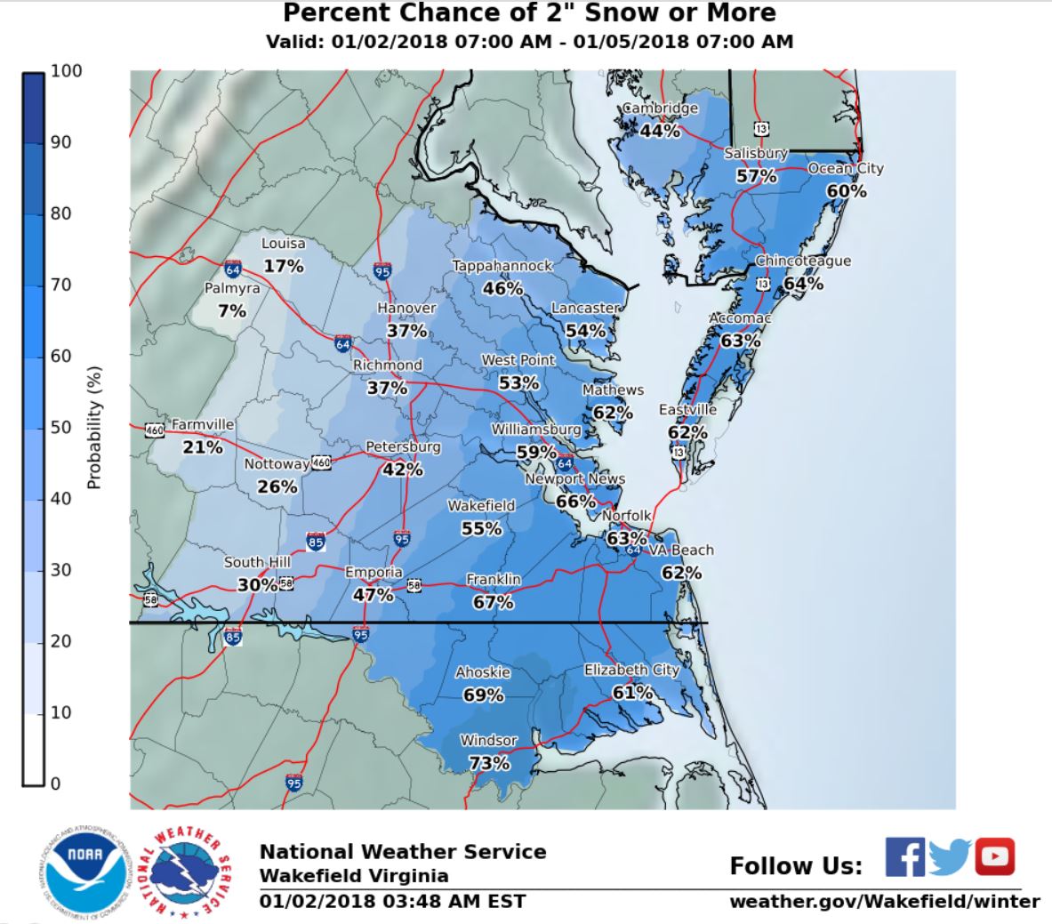
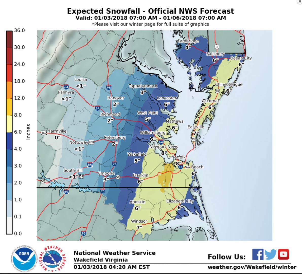
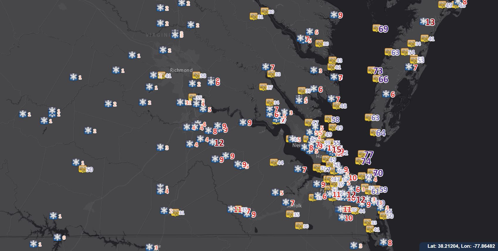
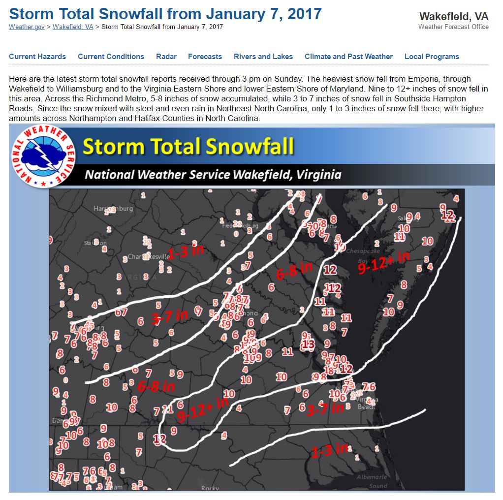
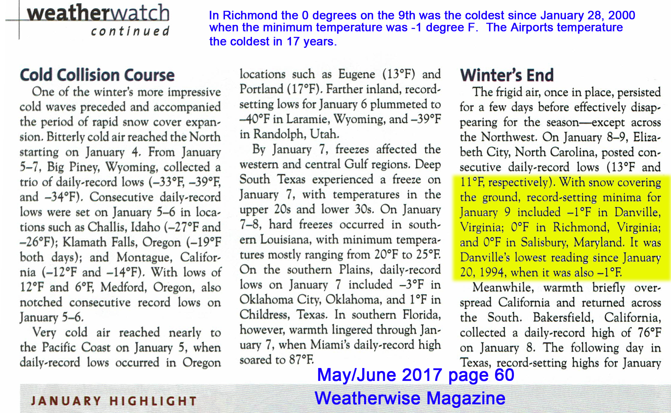
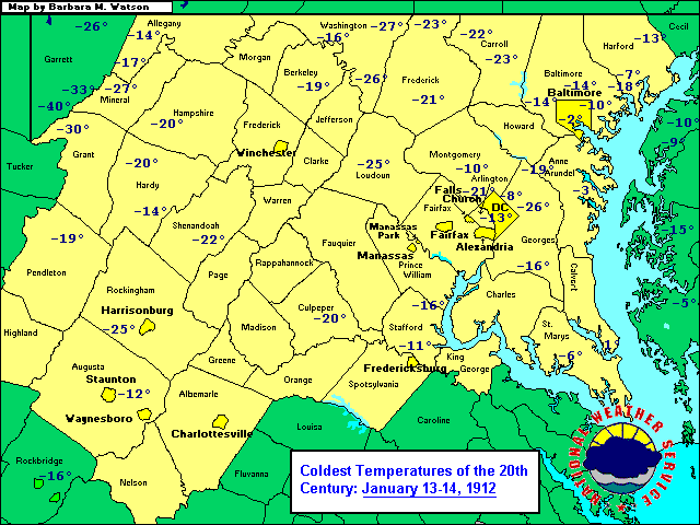
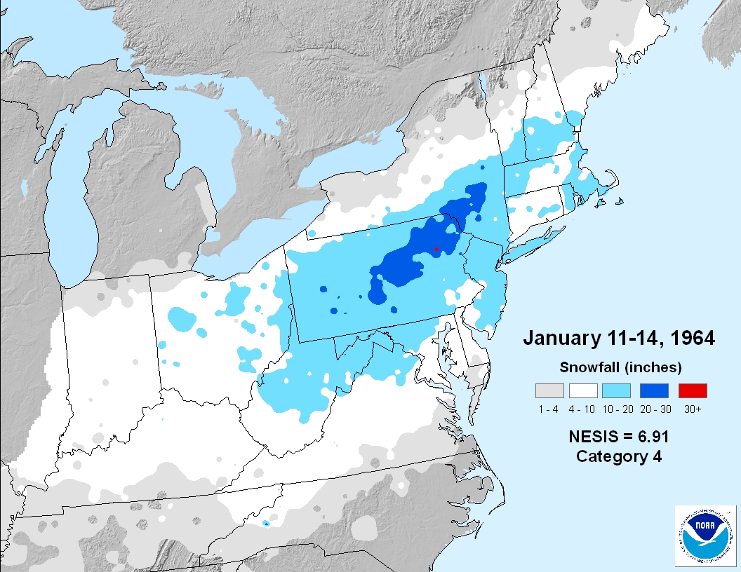
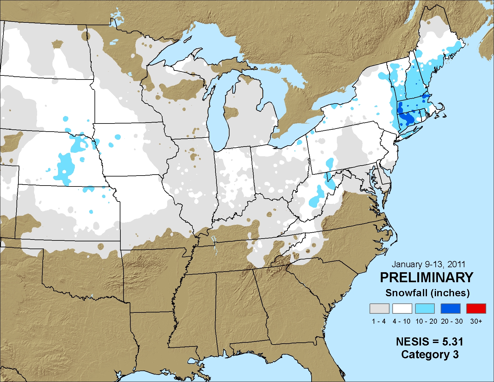
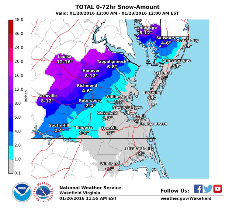
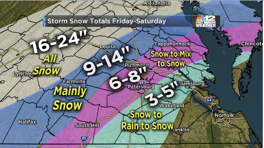
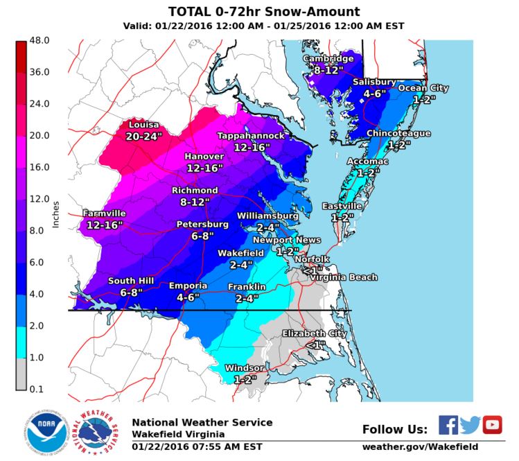
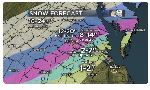
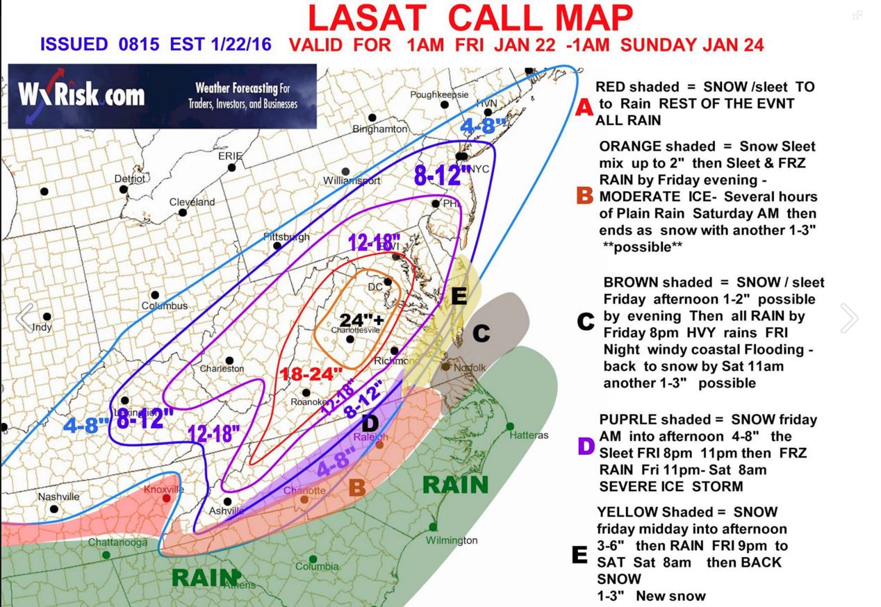
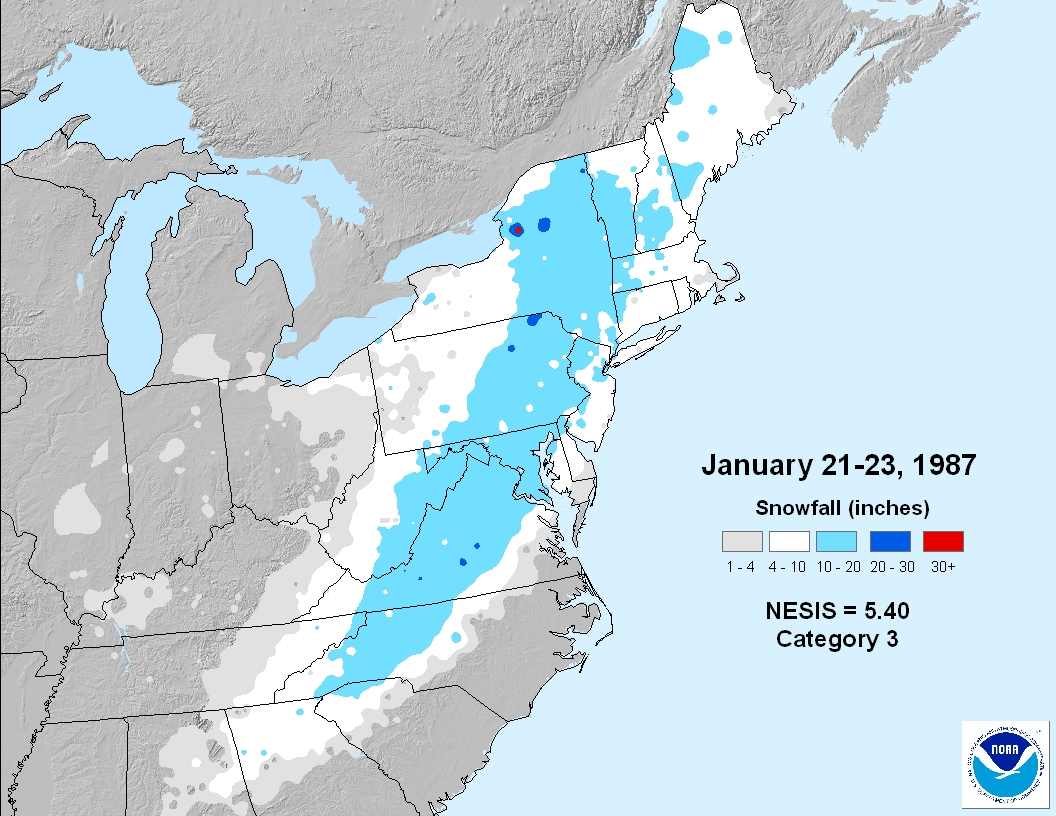
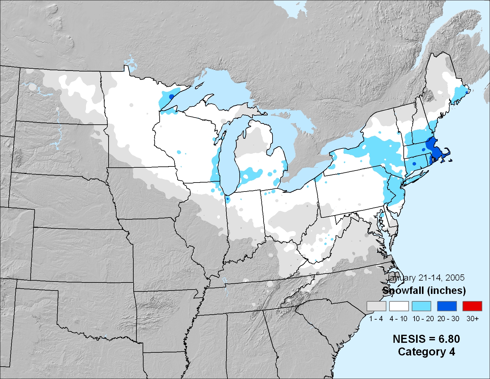
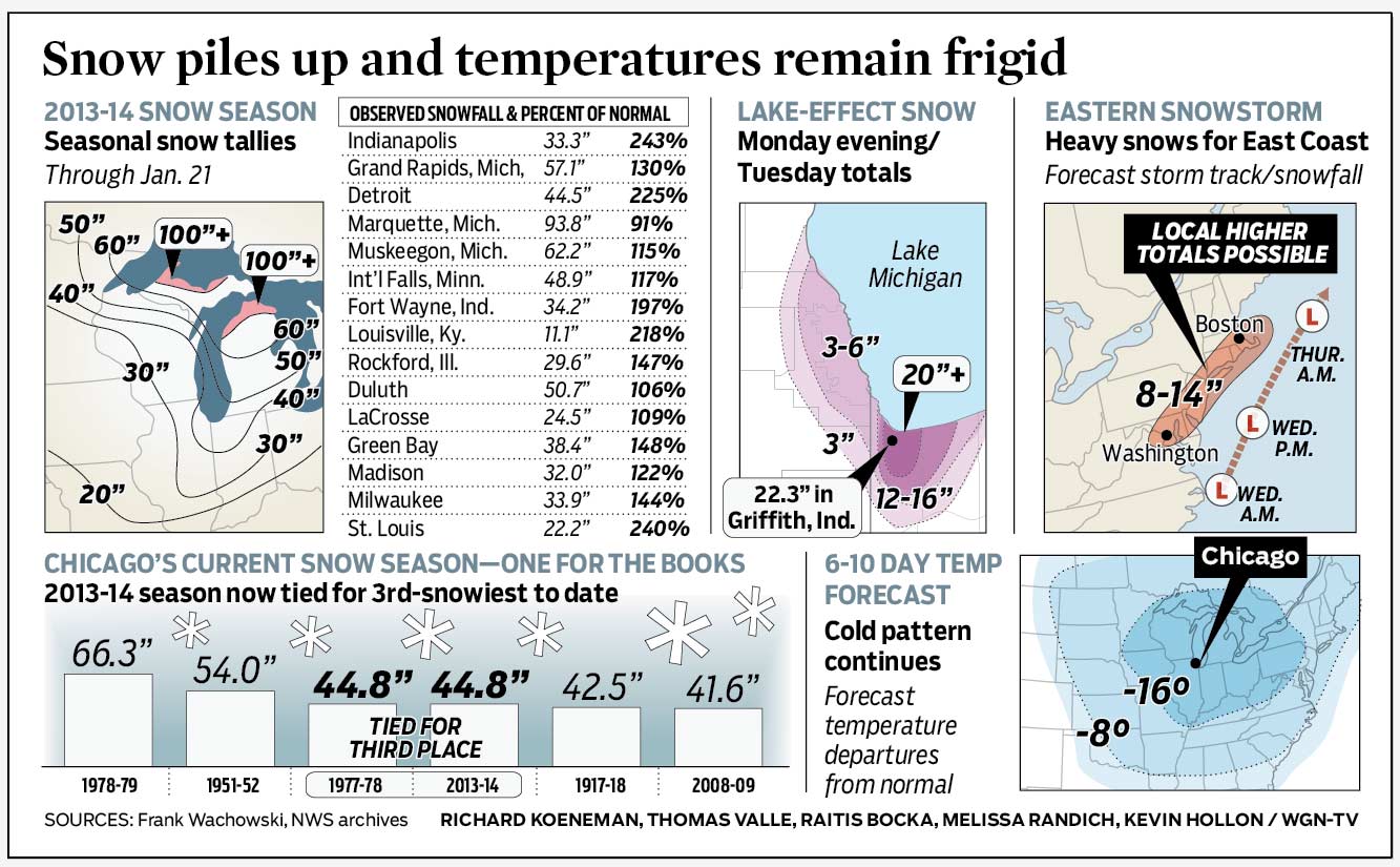
.JPG)
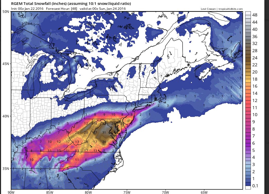
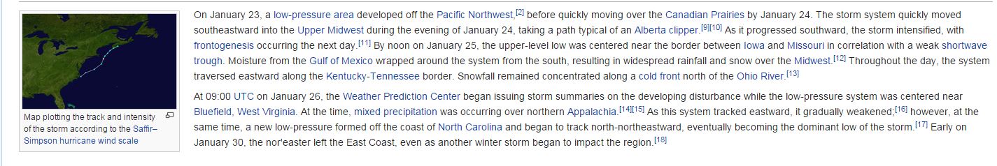
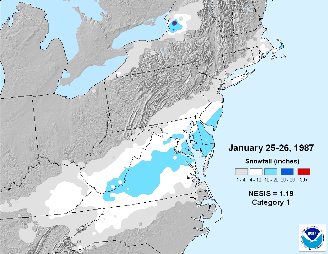
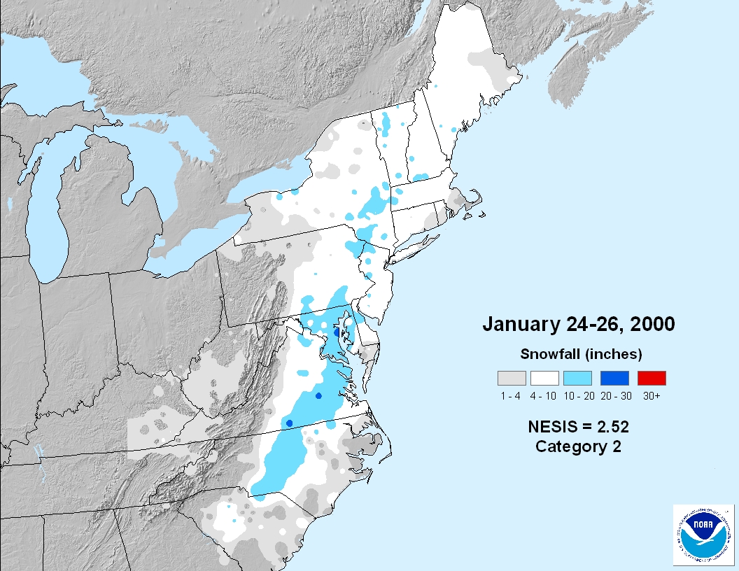
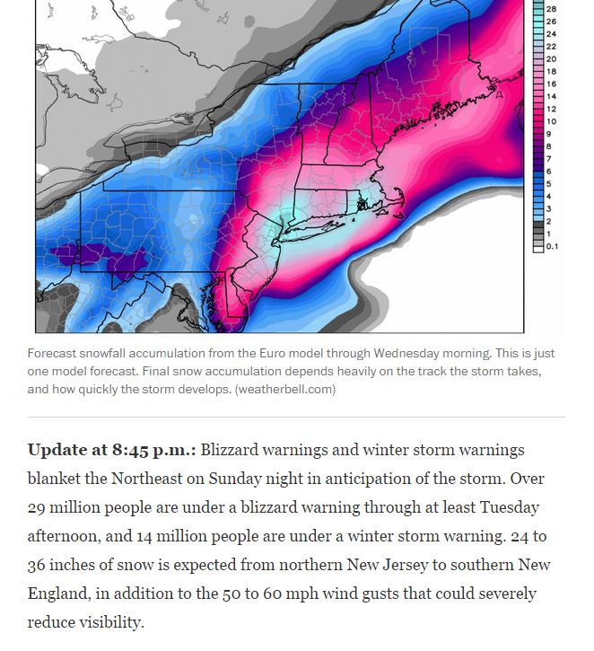
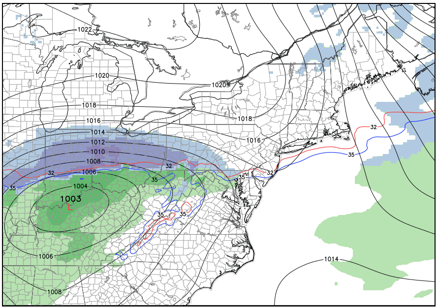
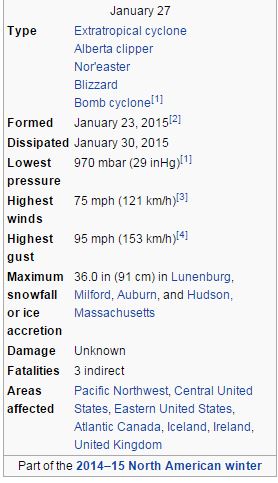
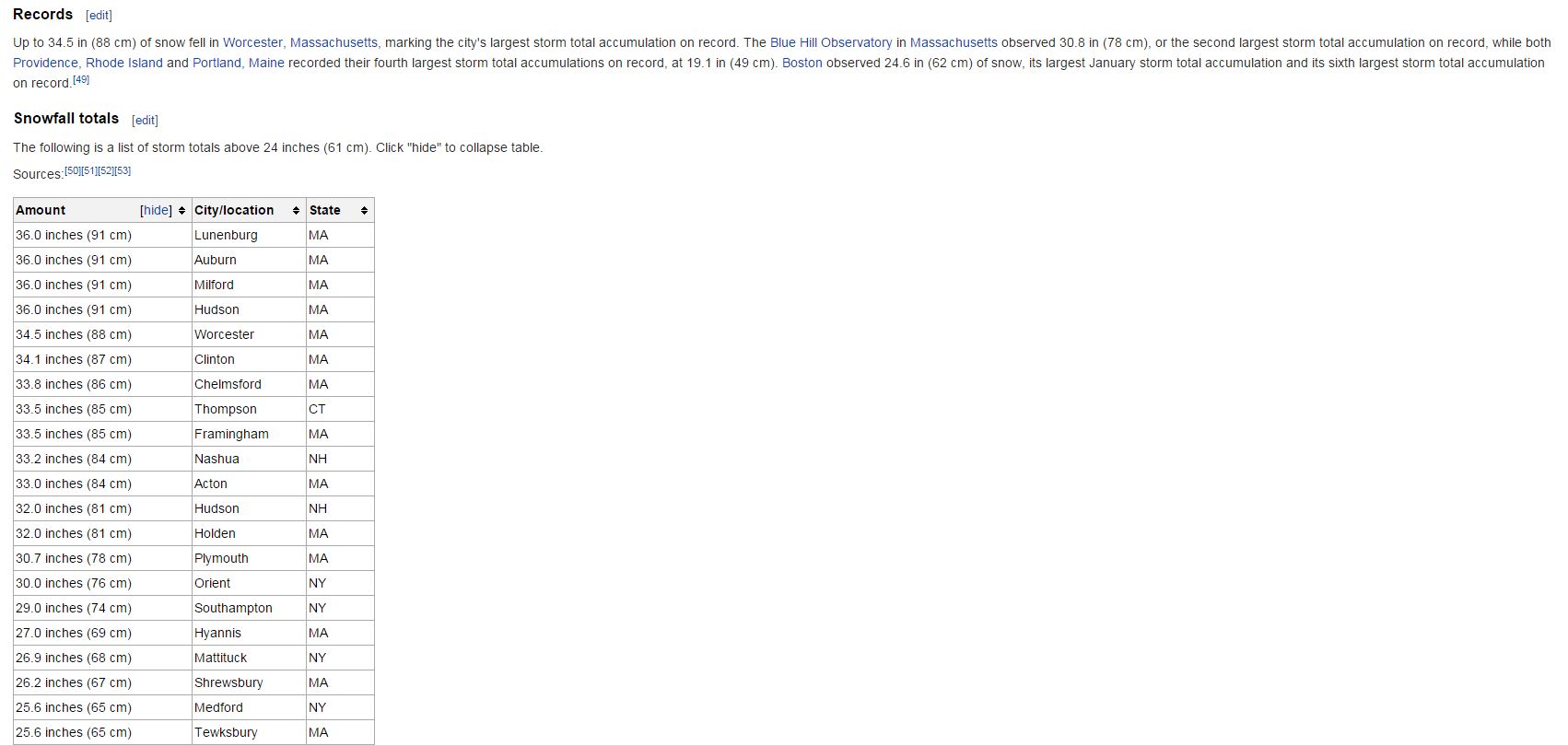
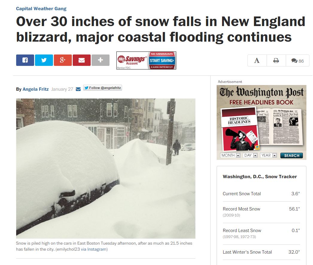
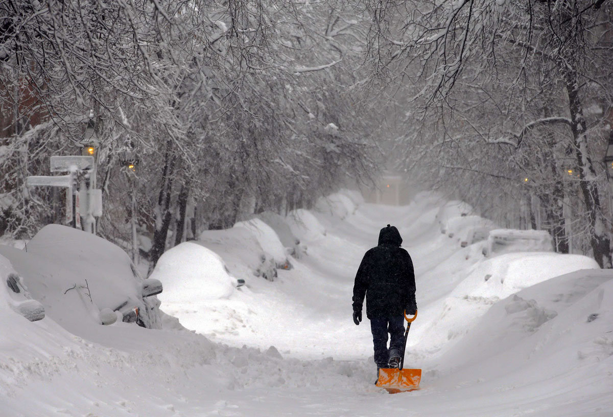
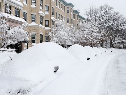
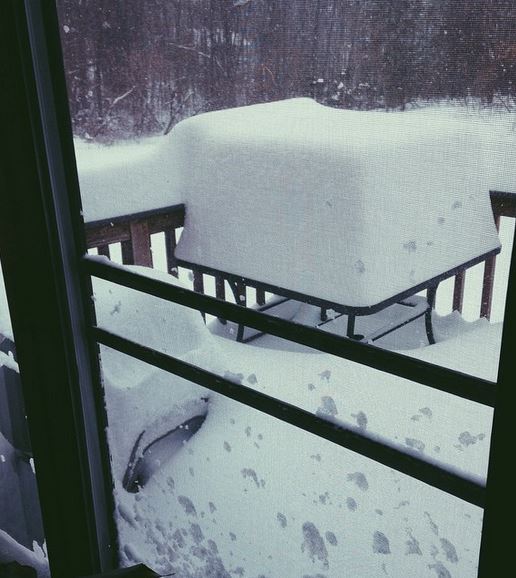
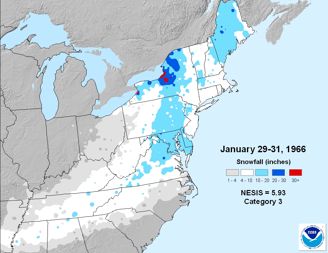
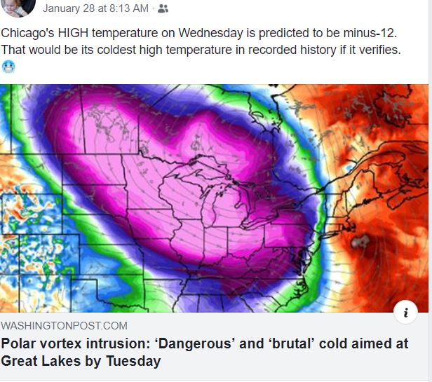